The Photogrammetry Education
for Multidisciplinary Geomatics in China

ZHU Qing: Member of the Scientific Program Committee, ISPRS 2008 BeiJing,
LIESMARS, Wuhan University, 129 LuoYu Road, Wuhan, P .R. China;
CHEN Jun: ISPRS Congress Director,
Chair, National Geomatics Center of China

ABSTRACT

After briefly review on the history of photogrammetry education in P.R.China, the development of undergraduate and graduate program, the corresponding curricula design are analyzed by using the data from Wuhan University in which the photogrammetry is awarded as the state-level key discipline. The academic educational program of photogrammetry in universities has trained students to perform tasks in all fields of the photogrammetric profession. In recent years, the nature of photogrammetry is changing and multidisciplinary geomatics are developing very rapidly, the educational program of photogrammetry has also been changed in new concepts and structures to adapt such new technologies and the extension of the field. Finally, the prospect of photogrammetry education for the requirements of multidisciplinary geomatics is proposed. The growing interest in fast and accurate 3D spatial data collection (such as city modeling and digital earth) results in the increasing need of photogrammetry as principal tool, photogrammetric courses are therefore requested to be up to date and to become one kind of the fundamental professional courses for university geomatics and remote sensing degree programs.

KEY WORDS: Photogrammetry, Education, Remote Sensing, Geomatics, China

1. INTRODUCTION

The word photogrammetry comes from Greek words photos (meaning "light"), gramma (meaning that which is drawn or written) and metron (meaning "to measure"). It originally signified measuring graphically by means of light (Whitmore and Thompson, 1966).

The development of photogrammetry can be traced back to the middle of the 19th century. Since the invention of the camera in the mid-1800s, photography has played a large role in surveying. With the conventional use of the airplane, an area called photogrammetry became a huge specialty of surveying. Photogrammetry is the tongue-twisting term for the science and technology of obtaining reliable measurements, maps, digital elevation models, and other GIS data primarily from aerial and space photography (http://www.asprs.org/career/). In summary, photogrammetry has undergone three well-known stages of development, i.e., analogue, analytical, and digital photogrammetry. The characteristics of these three stages are listed in Table 1. The academic education of photogrammetry has to adapt such development for qualified photogrammetric professionals.

Components and Parameters Stages of Development in Photogrammetry
Analogue Analytical Digital
Input Component Analogue Analogue Digit
Model Component Analogue Analytical Analytical
Output Component Analogue Digit Digit
Degree of Hardness 3 1 0
Degree of Flexibility 0 2 3

Table 1. The characteristics of the three stages of photogrammetry


In China, the aerial photographs and space images are the most significant data source of national basic geographic information, the photogrammetry are employed as the most effective official way to produce and update the national basic scale of topographic maps (1:10000 and 1:50000 ). In most cases, large scale of topographic maps (1:500, 1:1000, 1:2000) are also produced by photogrammetric methods for urban planning, highway and railway design, and so on. At the stages of analogue and analytical, photogrammetric instruments such as the stereoplotters were so expensive and complicated that the operator training was very difficult, and the operations then largely rely on the professional photogrammetrists with college education. Compared to the manual analytical stereoplotter, however, softcopy systems are easier in terms of operator training. Just need fairly good knowledge of the mapping business generally, as well as some basic computer skills, but don't have to be photogrmmetrists or have skills of stereoplotter operator, this opens up the number of people able to use it. Since 1996, the digital photogrammetric workstations (DPWs) on Windows NT became practical tools, two kinds of DPWs, i.e. the VirtuoZo by Wuhan University and the JX-4 by Chinese Academy of Surveying and Mapping Science, have been widely used in multidisciplinary applications. At present more than 2000 DPWs are employed by photogrammetrists and other geomatics professionals to collect different kinds of geographic information, for example, the digital elevation models (DEM), digital orthoimage maps (DOM), digital line graphs (DLG), photorealistic 3D city models, and so on. This type of multidisciplinary applications is sought by employers and usually translates into good jobs.

As we move into the 21st century, geomatics, composed of the disciplines of geodesy, cartography, photogrammetry and remote sensing, has evolved as a new discipline from the integration of surveying, mapping and GIS curricula. Related to the advanced information and communication technology (ICT), present photogrammetrist must be well versed in ortho image and 3D data acquisition from a variety of source data types: conventional and digital aerial photography, satellite imagery, laser scanning (LIDAR) and radar to name a few. As a provider of data to a wide variety of users, the photogrammetrist will make professional assessments of the spatial accuracy and integrity of these widely varied data types and will make recommendations for the application of these data in engineering and GIS analysis.

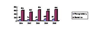
2. PHOTOGRAMMETRY DEGREE EDUCATION

2.1 Undergraduate and graduate program

Traditionally, most of the photogrammetric professionals are trained through the university degree education in China. After more than 70 years' development, multi-level photogrammetric programs have been changed greatly. As illustrated in Figure 1, the Chinese photogrammetry education is changed from only a few courses, then a well-developed independent specialty , and to a direction of integrated specialty at present.

imageIn 1932, the photogrammetry was firstly included as one of the major courses in the department of Surveying and Mapping, Tongji University, Shanghai, China. In 1952, the specialty of aerophotogrammetry was established in Tongji University. In 1956, the then Wuhan Technical University of Surveying and Mapping (now merged into the Wuhan University) was founded based on the collection of related specialities in Tongji University, Tianjing University, Tsinghua University, Nanjin Institute of Technology, South China Institute of Technology and Qiangdao Institute of Technology, and the specialty of aerophotogrammetry was set up in 1957. Almost during the same period, similar specialty is set up in the then Zhengzhou Institute of Surveying and Mapping (now Information Engineering University) and the then Tangshan Railway College (now Southwestern Jiaotong University) respectively (Li et al., 1987). With the development of remote sensing technology, the specialty of aerophotogrammetry was reformed as Photogrammetry and Remote Sensing in 1984. At present it is well-known that the photogrammetry is a part of remote sensing, which involves viewing objects stereoscopically to make accurate measurements. As an independent branch, photogrammetry and remote sensing becomes one of the most active and evolving fields in China. From 1984 to 1998, the Chinese photogrammetry education possessed its golden time. The past development of Chinese surveying and mapping discipline was referred to the specialty subdivision mode of Soviet Union, which plays important role in the planned economy of China (Ning, 2003).

In the decade, along with the rapid development of GIS and other geotechnologies, the traditional surveying and mapping disciplines, including cartography, photogrammetry and remote sensing, and geodesy, have evolved as a new discipline Surveying & Mapping Engineering similar to geomatics of other countries. Part of photogrammetry and remote sensing has been included in the specialty of Surveying & Mapping Engineering as Photogrammetry and Cartography direction since 1998 (Ning, 2000). Especially, the main photogrammetry direction is included in a new specialty named Science and Technology of Remote Sensing, which has been established for undergraduate major in five universities since 2003, even it is still not included in the catalogue. Since then, the systematic photogrammetry education has been weakened across the country, while it has been extended to multidisciplinary geomatics. Up to now, different levels of photogrammetric courses can be found in more than 50 universities and colleges of China.

As a training mode of broad-caliber specialized education based on comprehensive education, there are 8 fundamental professional courses designed for Surveying & Mapping Engineering undergraduate program, i.e. introduction to geomatics, the principles and methodology of digital mapping, error theory and surveying adjustment, geodetic foundation, spatial positioning technology and applications, photogrammetry and remote sensing, cartography, geographic information system and applications (Ning, 2000). From specialty subdivision to multidisciplinary integration, more and more geomatics professionals are able to acquire the photogrammetric knowledge and skills through university education, while the undergraduate program in photogrammetry as an independent degree education is hardly available.

For advanced-degree programs, i.e. M.Sc. or Ph.D. degree in photogrammetry and remote sensing, 10 universities and institutes were granted the power of awarding the Ph.D. degree, and more than 20 universities and institutes for master degree. In order for the emerging and developing of cross-disciplines, more and more strong enough universities have been granted to independently award the M. Sc. and Ph.D. degrees of all the second-class disciplines under certain first-class discipline since 1996. For example, under the first-class discipline of the science and technology of surveying and mapping, at present there are 8 universities can award the Ph.D. degrees of all the three second-class disciplines, i.e. geodesy and surveying engineering, cartography and geomatics, photogrammetry and remote sensing.

In China, all the undergraduate programs in photogrammetry specialty require students to pursue four-year full-time studies in education. However, the graduate programs provide the mobility of 1 degree structure Dipl.(1 to 2 years) and Ph.D.(3 years), and the tradition of 2 degree structure M.Sc. (2 to 3 years) and Ph.D. (3 to 6 years). Since 2004, a flexible M.Sc. degree program based on 2 years has become the main stream of photogrammetry education. Compared to the traditional 3 years' program, this program just decreases the credit hours for academic research and thesis, but it benefits graduates' earlier employment. In fact, this is a great change of education idea. When the Ph.D. students are enough to satisfy the requirements of academic research and education, the M.Sc. students are expected to be skillful in the solution of practical photogrammetric problems. Especially, in order to satisfy the increasing requirements of training qualified engineers for industrial and mining enterprises, the engineering graduate education (2 to 3 years' part-time studies) is also offered by universities together with the local organizations for skillful professionals.

Because Wuhan University provides the largest and the most important geomatics education for China, the recruit students number of each year is very typical to the development trend of whole China. In order to get an impression about the total number of phogrammetric students every year from Chinese Universities, see Figure 2 to 4. Even the demand for geospatial skills is growing worldwide, the undergraduates number keep a little change, and similar to Germany job market for a geomatics professional shown as in Table 2 (Konecny,2002), the photogrammetric undergraduate is also a small part of whole geomatics in China (about 10%). However, the number of geomatics M.Sc. and Ph.D. graduates has nearly doubled in the last five years (Figure 3 and Figure 4). This is the reason that growing market for M.Sc. and Ph.D. graduates is academia in the past, most of the graduates are selecting the faculty positions at universities, R&D positions at institutes or hi-tech companies, with the rapid development of science, technology and education in China the graduates number therefore rise more quickly than undergraduates. Even so, as GIS and remote sensing become two of the most important emerging and evolving fields in the decade, increasing M.Sc. theses and Ph.D. dissertations in photogrammetry and remote sensing are tightly related to GIS and remote sensing topics. As shown in Figure 5, only 12% M.Sc. and 23% Ph.D. are really in photogrammetric themes (aiming at the 3D geometric measuring from imageries).

image

Figure 2. Recruit undergraduates number of Wuhan University

image
Figure 3. Recruit M.Sc. graduates number of Wuhan University

image

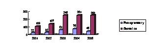
Figure 4. Recruit Ph.D. graduates number of Wuhan University

Employment sector Percentage
Terrestrial surveying 40%
Geodesy 5%
Photogrammetry and remote sensing 5%
GIS 30%
Land management 20%

Table 2. German job market for surveyors

image

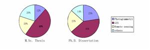
Figure 5. The research themes for M.Sc. and Ph.D. graduates in photogrammetry and remote sensing

2.2 Curriculum development

According to the undergraduate program in photogrammetry of Wuhan University, there are five different layers of courses as listed in Table 3. From 1996 to 2005, there are obvious curricula changes in the photogrammetry program as the specialty changed from photogrammetry and remote sensing to science and technology of remote sensing.

So many changes of curricula not only reflect the up-to-date contents of same courses (such as, various digital products and the evolving workflow of digital photogrammetry), but also coincide with the advanced geotechnologies as well as the information technologies. Such as the LiDAR, InSAR, Virtual Reality, image compression and database management system are included as standard courses. At the same time, the practice training is also strengthened in the integrated processing of multi-source data and multi-type digital production, the productions of DEM and DOM have become the basic contents of digital photogrammetry course.

The undergraduate photogrammetric curricula are designed into six parts, and the corresponding credit hours are listed in Table 4. Where, each credit hour equal to 18 lecture hours. In basic courses of comprehensive education, there are at least 12 credit hours for interdisciplinary options. These comprehensive curricula enable students to equally and comprehensively learn and foster with trainings in arts, social sciences, natural sciences and life sciences to substantiate the integral personality education. From this credit hours distribution, it is obvious that there are more than 50% credit hours designed for the common and fundamental courses, and only less than 15% credit hours for specialized courses. So more and more photogrammetric graduates can undertake other geomatics tasks, for example, the spatial database building and management, image processing and its applications, an so on.

Course Item 1996 2005
Basic courses of comprehensive education

advanced maths, linear algebra, probabilities and statistics, college physics

advanced maths, linear algebra, probabilities and statistics, college physics, C language programming
Disciplinary basic courses topographic drawing, geodesy, computer language, computer graphics, surveying adjustment foundation, data structure and database,aerial and spacephotography
introduction to geomatics, computer graphics, surveying, GIS principle, database principle, aerial and spacephotography, error theory and surveying adjustment foundation, digital image processing, pattern recognition, GPS principle and applications
Specialized courses photogrammetry foundation, digital photogrammetry, non-topographic photogrammetry, GIS, remote sensing, image processing photogrammetry foundation, digital photogrammetry, principles and methods of remote sensing, close-range photogrammetry, remote sensed image interpretation
Optional courses artificial intelligence & expert system, database principle virtual reality, computer vision, laser scanning system, microwave remote sensing, InSAR
Practice training topographic surveying, field and office photogrammetry, remote sensed image processing GPS application, digital surveying and mapping, remote sensed image processing, closerange photogrammetry, GIS and database design, digital photogrammetry and DEM/DOM/DLG production

Table 3. Part curricula description of photogrammetry undergraduate program

Course item Credit hours Percentage
Basic courses of comprehensive education 62.5 39.94
Disciplinary basic courses 29 18.53
Specialized courses 16.5 10.54
Optional courses 32.5 20.77
Practice training 10 6.39
Graduation project (thesis) 6 3.83
Total 156.5 100

Table 4. Credit hours distribution for 2004


2.3 Quality teaching resources

As we know, the implementation of good education program and curricula design greatly depends on quality teaching resources, such as the teachers' level of knowledge and ability, the text books, the teaching methodology and laboratory. In Wuhan University and Information Engineering University, the course content covers the entire photogrammetry field and full 3 degree structures (B.Sc., M.Sc., and Ph.D.) based on their perfect faculty and other teaching resources, but the emphasis of certain aspects of the discipline differs from university to university as shown in Table 5 and Table 6.

At Wuhan University, there are 12 full professors and 11 associate professors in photogrammetry, and most with Ph.D degrees. Therefore, the research and education cover almost all the photogrammetry field, such as photography, position and orientation system (POS) for sensors, automatic aerial triangulation, image matching and 3D reconstruction, close-range photogrammetry and mobile mapping, integration of "3S" (remote sensing, GPS and GIS), digital photogrammetric workstation, and so on. Especially, a full digital photogrammetric system Virtuozo, which is made in Wuhan Technical University of Surveying & Mapping ( WTUSM , now is merged in Wuhan University ), have been sold more than 3000 suites all over the world. VirtuoZo continues to earn a great deal of appreciation and respect from customers and competitors worldwide.

However, at other "poor" universities, there are very few faculties specialized in photogrammetry for only one or two general photogrammetric courses. In "adequate" universities, multi-level photogrammetry programs are provided, most universities offer the M.Sc. or Ph.D. degree education programs. In Table 5, part B.Sc. stands for the photogrammetry is not a specialty but a direction of geomatics, and only the "true" photogrammetry teachers are accounted for the 9 major related universities of China. In other words, the remote sensing and GIS teachers are not included. To exclude the first two "excellent" universities, there are 3 universities offer the M.Sc. degree program in photogrammetry as a direction of science and technology of remote sensing specialty. In fact, the photogrammetry education has been continued about 50 years in Southwest Jiaotong University, while started by 1998 in Chang'an University and until 2005 in Shandong University of Science and Technology.

After more than 50 years' development, a series of up-to-date teaching materials in Chinese or English have been published for multi-level photogrammetry education. Such as: Aerial Photogrammetry, Close-range Photogrammetry, Photogrammetry Foundation, Analytical Photogrammetry, Digital Photogrammetry, Error Process and Theory of Reliability, Digital Elevation Model, and so on. Especially, both the Chinese and English versions of 《Principles of Photogrammetry》 have been widely used as the text book all over the world, which was authored by Prof. WANG Zhizuo (the Honorary Member of ISPRS) in 1990. This book is highly appreciated at home and abroad. Book《Digital Terrain Modeling: Principles and Methodology》, published by CRC Press (Taylor & Francis Group), is also world widely used as teaching material.

University Prof. A. Prof. Lecturer Degree
Wuhan University 12 11 4 B.Sc. M.Sc. Ph.D.
Information Engineering University 9 8 17 B.Sc. M.Sc. Ph.D.
Southwest Jiaotong University 3 4 2 B.Sc. M.Sc. Ph.D.
Chang'an University 2 3 2 B.Sc. M.Sc.
Shandong University of Science and Technology 2 2 2 B.Sc. M.Sc. Ph.D.
Tongji University 3 2 1 Part B.Sc. M.Sc. Ph.D.
Central South University 1 1 2 Part B.Sc. M.Sc. Ph.D.
China University of Mining and Technology 1 1 3 Part B.Sc. M.Sc. Ph.D.
LiaoNing Technical University 2 2 Part B.Sc. M.Sc. Ph.D.

Table 5. University education resources for photogrammetry

University number Coverage
2 excellent
7 adequate
40 poor

Table 6. Emphasis of Chinese photogrammetry programs

In the decade, as one of the Chinese economic development achievements, all the university facilities, such as the classroom and laboratory, the teaching methods and devices, have been greatly improved. Based on the multi-media and network technologies, computer aided education becomes the important part of photogrammetry education all over the country. It is very popular to use the DPWs, various remote sensed image processing softwares, as well as GIS softwares for teaching and research purpose.

2.4 International cooperation

The international academic cooperation and exchange in photogrammetry education are very active in China. We have signed many agreements on cooperation with governments or universities all over the world. More and more teachers and students have the experiences of oversea study and / or research. Especially, in recent years the joint M.Sc. and Ph.D. programs in photogrammetry or geospatial information science have been carried out among Chinese universities and foreign universities, such as, the ITC (International Institute for Geo-Information Science and Earth Observation) of Netherlands, the Stuttgart University of Germany, AIT (Asian Institute of Technology) of Thailand, and so on. At the same time, increasing world-known photogrammetrists become the guest professor or honorary professor of Chinese universities, and are invited to China to give presentations or lectures every year. Under the umbrella of training section of national remote sensing center, since 1988 the foreign students have been trained in Wuhan University each year for the outer space committee of UN and Asia Pacific Economy and Society Council. At present, even in Wuhan University, there are more and more oversea students studying for M.Sc. or Ph.D. degrees in photogrammetry.

3. PROSPECT OF PHOTOGRAMMETRY EDUCATION


New technologies require new concepts in education. Today's technology trends towards fully automated (such as aerial triangulation, generation of DEMs and DOMs have been taken for granted) and real-time photogrammetry systems which reduce the role of traditional hard work of operator whose skill can be provided by reading a well-written manual. This holds true for hard- and software systems. These new technologies may be summarized into two categories (Gruen, 2005):

(1) Photogrammetry today is developed from point positioning and 2.5D mapping to an integrated, unified technology, encompassing satellite, aerial and terrestrial sensor platforms. The development of suitable curricula and implementation of programs therefore have to across traditional boundaries between photogrammetry, remote sensing and computer vision. While photogrammetry is employed as one of the most significant technologies for 2D DLG, DOM or 2.5D DEM data acquisition and updating, photogrammetry education is keen towards professional qualifications of photo-realistic 3D city modeling and augmented reality. Virtual city models are increasingly required to become a standard product of photogrammetric data collection. It is well-known that complete sets of 3D building models can be provided efficiently using airborne data collection. The collected 3D models usually represent not only the footprints of the buildings, but also the roof shapes. While the 3D geometric surface reconstruction becomes the main topics of photogrammetric courses, professionals are also required to acquire the skills of texture mapping for building facades, as well as the new technology for on the fly processing of multiple 3 line aerial and space image. As more and more 3D reconstruction from uncalibrated image sequences, the principle of 3D reconstruction based on projective geometry has become textbook knowledge.

(2) Photogrammetry today is also developed from single sensor/multiple processing instruments to multiple sensors/single processing platform technique. The traditional separate tasks of ground control, photography, data acquisition, processing and analysis will increasingly become complementary components of a single measuring and computing system, such as the POS technologies are being integrated into sensor frameworks. And the long feedback loop is shortened substantially: what used to be an elaborate cycle of data acquisition, analysis and visualization is being compressed into real time monitoring and control. The courses would cover the fusion methods of multi-source data, such as the GPS, GIS, POS, LIDAR and InSAR.

The photogrammetric technology is really evolving quickly, more and more opportunities is creating for the university education. In the meantime, only the rich universities offer up-to-date photogrammetry education (such as about the applications of LiDAR and digital cameras) because of the high cost of the technology and a shortage of expertise. In fact, it is also very essential to hire knowledgeable faculty all over the world for specific courses or workshops in time. Such as in Wuhan University, there is an annual summer school which consists of 2 to 3 training courses by world-known professors. This program aims at enhancing Geo-ICT (geospatial information and communication technology) related curriculum development and talent cultivation. At the same time, more and more foreign photogrammetric scholars are invited to give Chinese teachers and students a great way to stay informed about the latest knowledge and its future trend.

4. CONCLUDING REMARKS

We have seen that digital photogrammetry has become the pervasive technology in modern mapping. we can expect significant progress in the next few years.

Photogrammetry education towards professional qualifications has frequently been named as a key factor towards extending the reach of the geospatial industry, with the idea that qualified specialists ranging from IT-focussed via methodology-centered analyst to application experts. While this observation is certainly true and needs to be supported through the development of suitable curricula and implementation of programs across traditional boundaries between disciplines.

Current DPWs easily handle any type of imagery, including satellite, digital camera and video camera photography. Increasing photogrammetric solutions are designed for the GIS user with minimal or no photogrammetry training so they easy to learn and use and importantly offer a cost effective way for 2D/3D data collection. Accurate data creation and 3D object extraction for various GIS databases from digital imagery therefore become more and more popular since its high efficiency, low cost and greater accuracy. According to the economic and political plan of China, the creation of large scale of national and regional multidimensional spatial data infrastructure makes an entire market emerging around acquiring and selling photogrammetry-based data and is attracting an increasing number of graduates not only in photogrammetry but also in multidisciplinary geomatics. The new pretty face of photogrammetry education will attract more people to use it and it will transform the way multidimensional geospatial information acquisition.

Of course, a university education must prepare graduate with intellectual versatility in which the graduation is only the first step in a lifelong learning process, as technologies develop further, the pretty face of photogrammetry education will be constantly changing.

ACKNOWLEDGEMENTS

I'd like to acknowledge the contributions of many people who have provided information about Chinese photogrammetry education, this paper is also benefited from their comments and suggestions. Last but not least: thanks to Prof. LI Deren, Prof. XU Qing, Prof. QI Hua, Prof. JIANG Yan, Prof. TONG Xiaohua, Prof. LIU Qingyuan, prof. DU Peijun, Prof. SONG Weidong, Miss WEN Lin and Miss XU Min.

REFERENCES
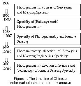
  1. Armin Gruen, 2005, Towards Photogrammetry 2025, Keynote of Photogrammetric Week 2005, September 5, 2005, Stuttgart, Germany.

  2. Deren Li, 2003, Some thoughts on developing the higher education of GIS in China, Science of Surveying and Mapping, 28(4): 4-5.

  3. Gottfried Konecny, Recent Global Changes in Geomatics Education, ISPRS Commission VI, Symposium, September , 2002, Sao Jose' dos Campos - Brazil.

  4. Ximu Li, et al., 1987, China Today: Surveying and Mapping, China Social Sciences Press, pp.303-332.

  5. Jinsheng Ning, 2002, Specialty of surveying and Mapping Engineering and Geomatics (i.e. Surveying and Mapping), Engineering of Surveying and Mapping, 9(2: 70-74.

  6. Jinsheng Ning, 2003, About the construction of GIS discipline from the development of surveying and Mapping, Science of Surveying and Mapping, 28(4): 1-3.

  7. G. Whitmore and M. Thompson, 1966, Introduction to Photogrammetry. In: Thompson, M. (ed.), Manual of Photogrammetry, American Society for Photogrammetry. 1-16.

imageThis site has been developed by Reed Business for ISPRS