|
5th International Symposium for Spatial Data Quality 2007
By Dr. Hande Demirel Prof. Dr. Alfred Stein
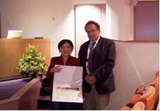
At the opening plenary session Prof. Martin Hale, Vice-Rector of ITC, Prof. Dr. Wolfgang Kainz President of ISPRS Technical Commission II and Prof. Dr. Alfred Stein , Symposium Chair, welcomed the participants. The long tradition of ITC, being a truly international community in the field of geo-information science and earth observation was emphasized as well as the collaboration between ISPRS and ITC. The opening keynote speaker, Prof. Dr. Lotfi Zadeh, from UC Berkeley, USA, held an exceptional speech on Granular Computing - Computing with uncertain, imprecise and partially true data, where participants had many stimulating discussions during the symposium. He challenged the audience in the end to consider the development of the science in general and geometry in particular when only fuzzy lines would have been generated by our ancestors. The technical committee of the symposium had reviewed and selected the oral and poster papers from previously submitted full-papers. Due to the amount of high quality contributions, parallel sessions were organized. At the first day of the symposium, two parallel sessions covered geo-information theory and spatial statistics. In order to discuss the subjects of geo-information theory and spatial statistics in detail, the same parallel session structure followed after the keynote speech of Prof. Dr. Shi from the Hong Kong Polytechnic University, Hong Kong. Prof. Dr. Shi emphasized the importance of "data quality in space and time" and presented developments and trends at spatial data quality. At the geo-information theory sessions eight oral papers were presented. Speakers mainly discussed the necessity of uncertainty determination and propagation in various application areas, such as infrastructural development, seismic assessments, 3D City Models. The other parallel session covered spatial statistics, new geo-statistical approaches and their applications on varying fields. Potential usage of geo-statistics at image classification was discussed, where the results showed performance and accuracy is increased. On varying applications from the cadastre, air quality and mobile radioactivity monitoring networks, geo-statistical methods were tested and results were discussed. The poster session attracted many participants and more than 30 papers were presented. An award for the best poster was announced, where the evaluation was done by the scientific committee on the basis of scientific content and presentation. Mrs. Yan Gao from Geography Institute of Mexico, Mexico received the award at the closing ceremony.
Prof. Stein presents the best poster award to Mrs. Yan Gao
The third keynote speech was held from Dr. Gerard Heuvelink, Wageningen University and Research Centre, the Netherlands. It was on data uncertainty engine at real-world applications, namely spatial planning and water basin management. Four other parallel sessions were held namely, Geo-information theory, applications, spatial statistics and quality in geo-information acquisition. Spatial quality of the remotely sensed data is the main focus of several applications. Logical consistency of spatio-temporal objects and relations was discussed in several studies, where possible solutions were presented.
|
|
|
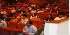 The 5th International Symposium for Spatial Data Quality (ISSDQ) was held in Enschede, the Netherlands from 13-15th June 2007, organized jointly by the International Institute for Geo-information Science and Earth Observation (ITC) and the ISPRS Commission II, Working Group 7, and attended by more than 120 participants. They came from 28 countries on 5 continents. The symposium brought together experts from around the world to present the latest developments in quantitative and qualitative approaches and information theory towards spatial data quality. The symposium focused on the five main spatial data quality themes: geo-information theory, spatial statistics, applications, quality in geo-information acquisition and dissemination/ fitness for use. Each session was opened by a keynote speaker, being a leading scientist in the field.