ISPRS e-Bulletin: July 2021


ISPRS e-Bulletin
Issue No 3 - 2021


Quick Links

•  ISPRS Homepage
•  Editorial
•  General Announcements
•  Reports
•  New Events
•  The ISPRS Foundation
•  TIF News
•  Scientific Meetings
•  Journal of Geo-Information
•  Obituaries
•  ISPRS Calendar
•  Society News
•  ISPRS Journal
•  New Events
•  Student Consortium
 

Editorial

Christian Heipke
 
Nicolas Paparoditis
     

2021 Digital Edition of the XXIV ISPRS Congress completed successfully

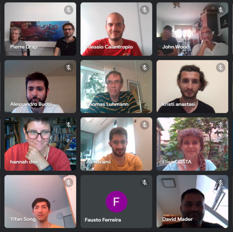
The 2021 Edition of the XXIV ISPRS took place online from July 5 – 9, 2021. While the 2020 digital meeting was basically a set of scientific presentations, this year’s event had nearly all features of a complete congress. In particular, the event included an opening session, a total of seven exciting keynotes, demonstrating the breadth and scientific depth of our field of work, and various awards ceremonies to honour those who have showed truly outstanding performance which has a lasting impact. A live science track with the best congress submissions, interactive poster sessions, and a technology track and a digital exhibition demonstrated the latest progress in our field, in both science and development, in academia and in industry. Two fora brought together different stakeholders, from within and beyond ISPRS, to discuss some of the most important applications of photogrammetry, remote sensing and geospatial information. Finally, on Friday, a geo-lecture day with various one-hour tutorials was held, which attracted a large number of participants as well.

Earth observation, space imagery and their use for science and society at large was a major topic of a number of key notes. Emanuel Flory from Airbus, introduced the Pléiades Neo constellation with four satellites, exhibiting a spatial ground resolution of 0,3 m. Airbus also asked ISPRS to organise an independent working group to independently assess the quality of the Pléiades Neo imagery and to report its results at the Nice Congress in summer 2022. Space imagery was also at the centre of the presentation by Claudio Almeida, from the Brazilian Space Agency INPE. Claudio presented the large and successful efforts INPE has carried out during the last two decades, to document and monitor vegetation and deforestation in the Amazon and other parts of Brazil. A.S. Kiran Kumar, the former chairman of the Indian Space Research Organisation ISRO, reported on the Indian space programme and demonstrated its sustained success in linking the latest technology with the needs and desires of the common man. Sara Gallagher, an advisor to the Canadian Space Agency, discussed the important role of earth observation for sustainable development and presented Canada’s contributions to space imagery, the Radarsat satellite and the new Radarsat constellation.

The relationship of photogrammetry, remote sensing, spatial information sciences and computer vision / computer graphics and their link to artificial intelligence, machine learning and big data were other overarching topics of the digital event at large, and the keynotes, in particular. Marc Pollefeys from ETH Zürich discussed new possibilities of the hololens, a portable device to interactively mix human and virtual vision, resulting in new and fascinating augmented reality applications. Christoph Stiller, Karlsruhe Institute of Technology, on the other hand, presented the current status of autonomous driving and, in particular, pointed out the relevance of geospatial data in this context – predicting safe traffic actions is only possible with precise knowledge the geometry of the lanes ahead, combined with traffic rules and thus admissible actions to be expected by other traffic participants.

Finally, Chenghu Zhou from the Chinese Academy of Sciences demonstrated the contribution of geospatial sciences and geospatial data in documenting, mitigating and overcoming health pandemics such as Covid 19. He clearly showed that mapping the distribution of the disease over time, detecting spatial and temporal infection patterns, investigating chains of infection, determining and tracking physical distances, as well as predicting future outbreaks based on mobility data all critically depend on data and tools made available by our community.

This topic was also in the centre of one of the fora, organised by Fazlay Faruque, University of Mississippi, and Laurent Polidori, Federal Rural University of Amazonia (formerly CESBIO/CNRS Toulouse) on “Geo for Pandemics”, in which experts from space agencies, the health sector and the geospatial field from around the world presented and discussed the overlap of the different fields in an attempt to define a roadmap for ISPRS to follow in the years to come.

The second forum, entitled “Towards Transformational Change: Potential Contributions of ISPRS and the Role of the Youth in Sustainable Development”, was organised by the ISPRS Student Consortium under the leadership of Sheryl Rose Reyes, University of the United Nations, together with Adele Roccato and Pierre Boileau, both from UNEP, the United Nations Development Programme. It featured, in particular, the GEO-6 for Youth report of UNEP, showing ways to limit and mitigate the effects of climate change, principally addressing the young generation.

During the first three days, the meeting featured a live track with the best papers accepted by the five ISPRS commissions after a rigorous double-blind peer-review process. In addition, pre-recorded videos of all accepted submissions were constantly available during the event. While, as usual, the papers are published in the ISPRS Annals and Archives proceedings series, the videos will be added to the ISPRS Media Library in the near future, and will thus also be available to the community. These videos form one new set of ISPRS assets, developed in, and due to the pandemic crisis. Another advantage of the online meeting was that participants around the world were able to join the congress, as there were of course no travel and accommodation costs, and the registration fee was kept to the absolute minimum; it was only necessary to have access to a suitable internet connection. As a result, scientists, practitioners and students from around the world, who would never have had a chance to participate in a traditional style ISPRS meeting, were able to join the digital edition of the congress. In all, this digital edition attracted 670 participants from 50 + countries with up to 470 per day.

Nevertheless, networking and informal communication, which is another key part of such meetings, were not possible in the same way as when meeting in person. Therefore, we would like to wholeheartedly invite you to attend the face-to-face edition of the XXIV Congress next summer and we do hope to see you in Nice during June 6 -11, 2022.


Christian Heipke, ISPRS President

Nicolas Paparoditis, ISPRS Congress Director


The ISPRS Foundation (TIF) News

TIF


Position Available: The ISPRS Foundation (TIF) Operations Officer

The ISPRS Foundation (TIF) Board of Trustees is seeking expressions of interest for the Operations Officer position to replace John Trinder, whose term on the Board of Trustees has expired. Please consider applying for this position if you have enthusiasm for …. Read more here.


ISPRS Student Consortium News

The ISPRS Foundation


The Youth Forum Track in the 2021 Digital Edition of the ISPRS Congress

In this years’ digital edition of the ISPRS Congress, the ISPRS Student Consortium (ISPRS SC) organized several events under the Youth Forum track. Our mentees for the ISPRS SC Leadership and Service Mentoring Programme joined us in organizing and hosting these events!

Read more…


Society News

ISPRS Logo


Call for Proposals
 
ISPRS Educational and Capacity Building Initiatives 2022 bar

In accordance with the statutory mission and activities of ISPRS, the Society shall provide funds to support educational and capacity building initiatives, which will further improve its international status in education and training in the field of the photogrammetry, remote sensing and spatial information sciences, and will therefore benefit all ISPRS members. For 2022, the ISPRS Council is making up to SFr. 70,000 available to support winning projects under the educational and capacity building initiatives. The maximum funding assigned to any one project shall be SFr. 10,000 per annum. Projects should commence on January 1, 2022 and typically last up to 12 months. In exceptional cases, applications for projects lasting up to 24 months will be considered. Projects of greater than one-year duration will be subject to annual review before subsequent funding will be released.

ISPRS Working Group Officers are invited to submit applications to their respective Technical Commission President by the deadline below, using the template provided (download the template here as MS-Word / PDF). The submission must be compiled in one PDF document. Further details, including information on the topics and the application process, are available in Appendix 9 of the Orange Book at: http://www.isprs.org/documents/orangebook/app9b.aspx

Past funded projects can be found at https://www.isprs.org/society/ecbi/default.aspx

All applications will be reviewed based on the following criteria:

  • Overall Benefits to ISPRS and its Community     
  • Merit of the Proposal                 
  • Competence of the Team          
  • Contribution to Education and Capacity Building            
  • Budget and Feasibility 

Any queries should be addressed to the ISPRS Treasurer, Songnian Li, at isprs-tr@isprs.org.

Timeline

Announcement of Scientific Initiatives: June 15, 2021.

Deadline for submission of proposals from WG Officers to TCPs: November 1, 2021.

Deadline for submission of recommendation from TCPs to ISPRS Treasurer: November 22, 2021.

Announcement of successful awards by Council: December 15, 2021.

Funding available from: January 1, 2022.


A report on the assessment of the Scientific Initiatives and Education and Capacity Building Initiatives projects have just been received from ISPRS Science Advisory Committee (ISAC). A short summary of ISAC’s recommendations is included in ISAC Recommendations on SI and ECBI Projects, which should provide additional guidance to the preparation of proposals. In addition, two thematic sessions on SI and ECBI initiatives will be organized on July 8, 2021 during 2021 ISPRS Virtual Congress. You are welcome to attend these sessions to learn more about the ISPRS initiative program.


ISPRS International Journal of Geo-Information — Open Access Journal      

ISPRS International Journal of Geo-Information – Associate Editors

To maintain the high quality of the published papers and to respond to the increasing number of submissions we are pleased to announce the appointment of associate editors for the journal. We have identified 11 main areas that cover the scope of our journal. For every area an associate editor will

  • Manage the editorial process for papers submitted to the Journal in the respective areas under the leadership of the Editor-in-Chief,
  • Ensure high quality scientific content for the Journal,
  • Work closely with the Guest Editors of special issues in the respective area, and
  • Work closely with the Editor-in-Chief and the Publisher on matters of the Journal's strategic directions and manuscript decisions.

Six of the positions have already been filled; the open positions will be filled in the near future. We welcome the new associate editors and wish them much success.

Spatial Data Modeling Sisi Zlatanova
Spatial Data Management vacant
Spatial Analysis and Decision Making vacant
Geospatial Artificial Intelligence Maria Brovelli
Cartography vacant
Spatial Data Infrastructures vacant
Geospatial Web Huayi Wu
Citizen Science, Crowd Sourcing and Volunteered Geographic Information Wei Huang
Location Based Services and Trajectory Analysis vacant
Urban Informatics, Smart Cities and Communities Mingshu Wang
Advanced Geospatial Applications Godwin Yeboah


ISPRS International Journal of Geo-Information — Open Access Journal      

ISPRS International Journal of Geo-Information Impact Factor on the Rise

We are pleased to inform that the latest Impact Factor (2020) for the ISPRS International Journal of Geo-Information is 2.899, increasing from 2.239 in 2019. Our Impact Factor has maintained its positive tendency of growth for 5 consecutive years!

  • Journal Impact Factor (2020): 2.899;
  • 5-Year Impact Factor (2020): 2.971;
  • CiteScore (2020): 4.6;
  • Ranking in Q1 (76/704) in the category 'Geography, Planning and Development', Scopus;
  • Ranking in Q1 (27/106) in the category 'Earth and Planetary Sciences (miscellaneous)', Scopus;
  • Ranking in Q1 (13/52) in the category 'Computers in Earth Sciences’, Scopus;
  • Ranking in Q2 (76/162) in the category 'Computer Science, Information System', Web of Science;
  • Ranking in Q2 (23/50) in the category 'Geography, Physical', Web of Science;
  • Ranking in Q3 (19/32) in the category 'Remote Sensing', Web of Science.


ISPRS International Journal of Geo-Information — Open Access Journal      

Last Call for Papers
 
Special Issue "GIS in Healthcare" ISPRS International Journal of Geo-Information

The entire healthcare sector, including health businesses, academia, and policy makers, is facing a challenge to become more efficient by reducing costs while reaching out to a broader range of communities. GIS is a proven tool for improving efficiency and planning in different areas of healthcare. From non-critical applications, such as primary care or preventive care, to critical situations, such as emergency care or organ replacement, GIS is increasingly being utilized to develop better business models and make lifesaving decisions. This Special Issue of IJGI is expected to serve as a knowledge exchange platform presenting the latest advancements in GIS applications in a dynamic healthcare landscape.

Visit the following link to submit your manuscript.

https://www.mdpi.com/journal/ijgi/special_issues/gis_health


Mary Ann Kutny


New ICORSE Chair

Mary Ann Kutny, Deputy Director of International and Interagency Affaires Division, NOAA, has taken over the position of Chair of ICORSE from her predecessor, Yana Gevorgyan (also from NOAA).

ISPRS congratulates Mary Ann on her new position and looks forward to continuing the fruitful collaboration of the past. We also thank Yana for her work chairing ICORSE, and wish her all the best for the future.


General Announcements

International Science Council GEOUNION      

The GeoUnions Standing Committee on Disaster Risk Reduction

Policy Briefs 3 and 4
bar

Dear Colleagues and Friends,

Recent devastating floods in Germany and Heatwaves in Northern America, especially in Canada, showed us that Disasters (Disaster Risk Reduction, DRR) are one of the most important research items of the future. It has also proven that the Government and society must prepare better for these types of events.

The GeoUnions Standing Committee on Disaster Risk Reduction (ISC-GU-SC-DRR) was established in July 2020, initiated and led by Prof.  Orhan Altan, who was nominated by International Science Council (ISC) GeoUnions Steering Committee and ISPRS. The newly established Committee seeks to strengthen the long-standing ISC leadership in advancing DRR. It also honours the ISC’s (former ICSU’s) role in the preparation of world conferences on DRR. The Committee will work to:

  • Facilitate communications amongst international geoscience bodies, governmental and non-governmental organizations to identify, support, and advance initiatives to implement the Sendai Framework through interdisciplinary action.
  • Coordinate and support implementation initiatives for disaster risk management in accord with the principles and goals of the Sendai Framework.
  • Organize conferences and workshops at a regional and global level to advance disaster risk management initiatives.
  • Advise on the rationale and role that science should play in disaster risk management and work to strengthen that rationale and role.
  • Increase the awareness and action by the GeoUnions in Disaster Risk Reduction and the implementation of the Sendai Framework as further defined by the ISC report and focus that interest through the publications of the periodic reports on its progress.
  • Seek for proper financing to continue its activities. The Committee will work with the ISC and possible other donors and/or agencies to consider options for adequate funding.
  • Release statements on DRR from time to time on changing situations.

The Committee Membership will include a maximum of 10 regular voting members. The representatives of the GeoUnions will comprise the sustaining members. The following GeoUnions are represented:

  • International Astronomical Union (IAU)
  • International Cartographic Association (ICA)
  • International Geographical Union (IGU)
  • International Society for Photogrammetry and Remote Sensing (ISPRS)
  • International Union of Geodesy and Geophysics (IUGG)
  • International Union of Geological Sciences (IUGS)
  • International Union of Quaternary Research (INQUA)
  • International Union of Radio Sciences (URSI)
  • International Union of Soil Sciences (IUSS)

The latest developments, especially the Covid-19 spread in the world and recent major environmental problem that occurred in Istanbul and around the Marmara Sea off coast alarmed the Committee to publish Policy Briefs to the Governments, Decision Makers and International Institutions, Communities on how to react to these disasters.

Orhan ALTAN

Chair of the ISC GUSC DRR


Mathias Lemmens      

Major new Geomatics Publication by Mathias Lemmens

Whittles Publishing has announced forthcoming publication of An Introduction to Pointcloudmetry, Point Clouds from Laser Scanning and Photogrammetry by Mathias Lemmens.

Lemmens has a long record of developing and teaching courses at DUT Netherlands, Department of Earth Observation Science, University of Twente, NL and IIT Kanpur, India. With over 35 years of academic experience he is an appreciated teacher and valued communicator.

Read here for more information…


COSPAR      

News Release
 
COSPAR updates its Planetary Protection Policy for Missions to the Moon’s Surface

Read more here…


Announcements of Scientific Meetings                (see also ISPRS Calendar)

Arzu Coltekin      

Save the Date – Next ISPRS Virtual Keynote: 30 September 2021 at 12 noon UTC

bar

The next Virtual Keynote Speaker is Prof. Dr. Arzu Çöltekin, from the University of Applied Sciences and Arts Northwestern Switzerland FHNW. The title of her Keynote is Human cognition and visuo-spatial information: Experiments in visualization and virtual reality.

Title: Human cognition and visuo-spatial information: Experiments in visualization and virtual reality

Abstract: In this talk, Prof. Çöltekin shares various research perspectives on human factors in visualization, virtual reality, photogrammetry and remote sensing. Example projects are highlighted on route learning in the context of navigation, specifically by older adults, and a visual illusion in depth perception in shaded relief maps and satellite images.

Bio: Prof. Dr. Arzu Çöltekin works at the University of Applied Sciences and Arts Northwestern Switzerland's Institute for Interactive Technologies as a Professor of Human-Computer Interaction and Extended Reality. She is also a research affiliate at the Seamless Astronomy group in the Harvard-Smithsonian Center for Astrophysics of the Harvard University in Cambridge, USA, which specializes in scientific data analysis and visualization.  Dr. Çöltekin chairs the international Geovisualization, Augmented and Virtual Reality working group of the ISPRS; co-chair the Commission on Visual Analytics of the ICA, and a council member with the International Society of Digital Earth.

Further information will be available closer to the date.


CODATA RD      

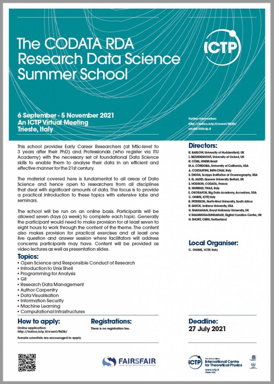
The CODATA RDA - Research Data Science Summer School

6 September - 5 November 2021
An ICTP Virtual meeting
Trieste, Italy

Given the fully virtual format of the Data School this year, it is a significant opportunity for Early Career Researchers to get an introduction to core data skills.

This year's event is hosted virtually by the ICTP and supported by the FAIRsFAIR Project.
The deadline for applications is 27 July 2021: http://indico.ictp.it/event/9638/

Applications are open for this year’s Summer School, providing Early Career Researchers (at MSc-level to 3 years post PhD) and Data Professionals (registering via ITU Academy) with the necessary set of foundational Data Science skills to enable them to analyse their data in an efficient and effective manner for the 21st century.

The material covered is fundamental to all areas of Data Science and is therefore open to researchers from all disciplines dealing with significant amounts of data.  The focus is to provide a practical introduction to the topics with extensive labs and seminars.

The School will be run on an online basis and participants will be given a week to complete each topic.  Participants will need to allow at least 7 to 8 hours to work through the content of the topic.  The content also provides practical exercises and at least one live question and answer session where facilitators will address any issues the participants may have.  Content will be provided as video lectures as well as presentation slides.

Topics: Open Science and Responsible Conduct of Research; Introduction to Unix Shell; Programming for Analysis; Git; Research Data Management; Author Carpentry; Data Visualisation; Information Security; Machine Learning; Computational Infrastructures.
Participation for selected candidates is free.  The Data School is open for all Early Career Researchers (ECRs).  Thanks to support from FAIRsFAIR and our hosts at ICTP, applications from ECRs from European and from Low and Middle Income Countries are particularly encouraged.
Application and further information http://indico.ictp.it/event/9638/ – Deadline 27 July 2021.

CODATA RD

Closing Soon! CODATA Call for Task Group Proposals: deadline 12 July

Webinar on SARS-CoV-2 genomics and data analysis in the UK, 22 July: information and registration

Applications Open: CODATA-RDA Research Data Science Summer School 2021, 6 Sept-5 Nov 2021: deadline 27 July

Global Open Science Cloud Initiative: introduction event and sign up for WGs and Case studies

1st International Forum on Big Data for Sustainable Development Goals: 6-8 September 2021

CODATA Connect-Data Science Journal Early Career Essay Competition: deadline 31 August

Call for Proposals to Host International Data Week 2025: deadline 30 September 2020

May 2021 publications in the CODATA Data Science Journal

Stay in touch with CODATA:

Stay up to date with CODATA activities: join the CODATA International News list

Looking for training and career opportunities in data science and data stewardship?  Sign up to the CODATA early career community-run data science training and careers list

Follow us on social media! Twitter - Facebook - LinkedIn - Instagram


International Conference on “Measurement, Visualisation and Processing in BIM for Design and Construction Management II”

February 7-8, 2022
Czech Technical University in Prague

Read more here…

For further details, please visit  https://www.mvpbim2022.com/


Reports


Report on the 1st Virtual Meet-up Event of the ISPRS WGII/9 – Underwater Data Acquisition and Processing

8-9 June 2021

Read the report here…


Obituaries

Douglas J. King      

Douglas J. King † 12 May 2021
bar

The CRSS-SCT was deeply saddened to learn that Dr. Douglas J. King passed away 12 May 2021. As Professor at Carleton University who had just retired in 2019, Doug was a pioneer in airborne remote sensing and applications, an outstanding teacher, supervisor and mentor, and a friend to many. Our deepest condolences to Doug’s family.

Please see the news post linked here for more details: https://carleton.ca/geography/2021/mourning-the-loss-of-dr-doug-king/


La CRSS-SCT est profondément attristée d'apprendre le décès du Dr Douglas J. King, le 12 mai 2021. Professeur à la retraite depuis 2019 de l'Université Carleton, Doug était un pionnier de la télédétection aéroportée et de ses applications, un enseignant, un superviseur et un mentor hors pair, et un ami pour beaucoup. Nos plus sincères condoléances à la famille de Doug.

Pour de plus amples renseignements, veuillez consulter - https://carleton.ca/geography/2021/mourning-the-loss-of-dr-doug-king/


ISPRS International Journal of Geo-Information — Open Access Journal

ISPRS International Journal of Geo-Information — Open Access Journal      

New publications in the ISPRS International Journal of Geo-Information
Open Access Journal
Volume 10, Issue 6 (June 2021)

Usage of Airborne Hyperspectral Imaging Data for Identifying Spatial Variability of Soil Nitrogen Content
Pechanec, Vilém, Mráz, Alexander, Rozkošný, Ladislav, Vyvlečka, Pavel
No: 355

Virtual 3D Campus for Universiti Teknologi Malaysia (UTM)
Salleh, Syahiirah, Ujang, Uznir, Azri, Suhaibah
No: 356

An Unconventional Field Mapping Application: A Complete Opensource Workflow Solution Applied to Lithological Mapping of the Coatings of Cultural Heritage
Iandelli, Niccolò, Coli, Massimo, Donigaglia, Tessa, Ciuffreda, Anna Livia
No: 357

Land Use Change Ontology and Traffic Prediction through Recurrent Neural Networks: A Case Study in Calgary, Canada
Azad, Abul, Wang, Xin
No: 358

Examining the Effect of Squatter Settlements in the Evolution of Spatial Fragmentation in the Housing Market of the City of Buenos Aires by Using Geographical Weighted Regression
Ogas-Mendez, A. Federico, Isoda, Yuzuru
No: 359

Roman Aqueduct Flow Estimation Using Geomatic Measurement
Alimonti, Claudio, Baiocchi, Valerio, Bonanotte, Giorgia, Molnár, Gábor
No: 360

Assessment and Visualization of OSM Consistency for European Cities
Zacharopoulou, Dimitra, Skopeliti, Andriani, Nakos, Byron
No: 361

A Common Approach to Geo-Referencing Building Models in Industry Foundation Classes for BIM/GIS Integration
Zhu, Junxiang, Wu, Peng
No: 362

Risk Assessment of Population Loss Posed by Earthquake-Landslide-Debris Flow Disaster Chain: A Case Study in Wenchuan, China
Han, Xiang, Yin, Yunhe, Wu, Yuming, Wu, Shaohong
No: 363

Improving Victimization Risk Estimation: A Geographically Weighted Regression Approach
Ramos, Rafael G.
No: 364

Pedestrian Routing and Perspectives: WayFinder’s Route down the Lane—Come on with the Rain
Opach, Tomasz, Navarra, Carlo, Rød, Jan Ketil, Neset, Tina-Simone
No: 365

Assessment of Influencing Factors on the Spatial Variability of SOM in the Red Beds of the Nanxiong Basin of China, Using GIS and Geo-Statistical Methods
Yan, Ping, Lin, Kairong, Wang, Yiren, Tu, Xinjun, Bai, Chunmei, Yan, Luobin
No: 366

Comparing High Accuracy t-LiDAR and UAV-SfM Derived Point Clouds for Geomorphological Change Detection
Alexiou, Simoni, Deligiannakis, Georgios, Pallikarakis, Aggelos, Papanikolaou, Ioannis, Psomiadis, Emmanouil, Reicherter, Klaus
No: 367

Paradigm of Geological Mapping of the Adıyaman Fault Zone of Eastern Turkey Using Landsat 8 Remotely Sensed Data Coupled with PCA, ICA, and MNFA Techniques
Khalifa, Abdelrahman, Bashir, Bashar, Çakir, Ziyadin, Kaya, Şinasi, Alsalman, Abdullah, Henaish, Ahmed
No: 368

Do Mobile Phone Data Provide a Better Denominator in Crime Rates and Improve Spatiotemporal Predictions of Crime?
Rummens, Anneleen, Snaphaan, Thom, Van de Weghe, Nico, Van den Poel, Dirk, Pauwels, Lieven J. R., Hardyns, Wim
No: 369

A Novel Heuristic Emergency Path Planning Method Based on Vector Grid Map
Yang, Bowen, Yan, Jin, Cai, Zhi, Ding, Zhiming, Li, Dongze, Cao, Yang, Guo, Limin
No: 370

Detecting Multi-Decadal Changes in Seagrass Cover in Tauranga Harbour, New Zealand, Using Landsat Imagery and Boosting Ensemble Classification Techniques
Ha, Nam-Thang, Manley-Harris, Merilyn, Pham, Tien-Dat, Hawes, Ian
No: 371

A GloVe-Based POI Type Embedding Model for Extracting and Identifying Urban Functional Regions
Zhang, Chengkun, Xu, Liuchang, Yan, Zhen, Wu, Sensen
No: 372

Analysis of Geotagging Behavior: Do Geotagged Users Represent the Twitter Population?
Karami, Amir, Kadari, Rachana Redd, Panati, Lekha, Nooli, Siva Prasad, Bheemreddy, Harshini, Bozorgi, Parisa
No: 373

An Analysis of Existing Production Frameworks for Statistical and Geographic Information: Synergies, Gaps and Integration
Ariza-López, Francisco Javier, Rodríguez-Pascual, Antonio, Lopez-Pellicer, Francisco J., Vilches-Blázquez, Luis M., Villar-Iglesias, Agustín, Masó, Joan, Díaz-Díaz, Efrén, Ureña-Cámara, Manuel Antonio, González-Yanes, Alberto
No: 374

Evaluating and Visualizing Drivers of Coastline Change: A Lake Ontario Case Study
Caspell, Meredith, Vasseur, Liette
No: 375

A Proposal for a User-Oriented Spatial Metadata Profile
Kalantari, Mohsen, Syahrudin, Syahrudin, Rajabifard, Abbas, Hubbard, Hannah
No: 376

Road Characteristics Detection Based on Joint Convolutional Neural Networks with Adaptive Squares
Kuo, Chiao-Ling, Tsai, Ming-Hua
No: 377

The Use of UAV in Cadastral Mapping of the Czech Republic
Šafář, Václav, Potůčková, Markéta, Karas, Jakub, Tlustý, Jan, Štefanová, Eva, Jančovič, Marián, Cígler Žofková, Drahomíra
No: 380

Methodological Proposal for Automated Detection of the Wildland–Urban Interface: Application to the Metropolitan Regions of Madrid and Barcelona
Zambrano-Ballesteros, Andrea, Nanu, Sabina Florina, Navarro-Carrión, José Tomás, Ramón-Morte, Alfredo
No: 381

A Multi-Scale Virtual Terrain for Hierarchically Structured Non-Location Data
Xin, Rui, Ai, Tinghua, Zhu, Ruoxin, Ai, Bo, Yang, Min, Meng, Liqiu
No: 379

Spatial Characteristics of the Tourism Flows in China: A Study Based on the Baidu Index
Liu, Yongwei, Liao, Wang
No: 378

Wildland Fire Susceptibility Mapping Using Support Vector Regression and Adaptive Neuro-Fuzzy Inference System-Based Whale Optimization Algorithm and Simulated Annealing
Al-Fugara, A’kif, Mabdeh, Ali Nouh, Ahmadlou, Mohammad, Pourghasemi, Hamid Reza, Al-Adamat, Rida, Pradhan, Biswajeet, Al-Shabeeb, Abdel Rahman
No: 382

A Study of Diffusion Equation-Based Land-Use/Land-Cover Change Simulation
Jin, Min, Feng, Ruyi, Wang, Lizhe, Yan, Jining
No: 383

Remote Sensing Methods for the Biophysical Characterization of Protected Areas Globally: Challenges and Opportunities
Martínez-López, Javier, Bertzky, Bastian, Willcock, Simon, Robuchon, Marine, Almagro, María, Delli, Giacomo, Dubois, Grégoire
No: 384

Distribution Patterns and Multilevel Factors of the Innovation Activities of China’s New Energy Vehicle Industry
Zhang, Kaihuang, Qian, Qinglan, Feng, Zhixin
No: 385

Extending Geodemographics Using Data Primitives: A Review and a Methodological Proposal
Gray, Jennie, Buckner, Lisa, Comber, Alexis
No: 386

The Spatiotemporal Interaction Effect of COVID-19 Transmission in the United States
Liu, Lingbo, Hu, Tao, Bao, Shuming, Wu, Hao, Peng, Zhenghong, Wang, Ru
No: 387

INS Error Estimation Based on an ANFIS and Its Application in Complex and Covert Surroundings
Duan, Yabo, Li, Huaizhan, Wu, Suqin, Zhang, Kefei
No: 388

Exploring the Spatiotemporal Patterns of Residents’ Daily Activities Using Text-Based Social Media Data: A Case Study of Beijing, China
Liu, Jian, Meng, Bin, Wang, Juan, Chen, Siyu, Tian, Bin, Zhi, Guoqing
No: 389

Reference Evapotranspiration (ETo) Methods Implemented as ArcMap Models with Remote-Sensed and Ground-Based Inputs, Examined along with MODIS ET, for Peloponnese, Greece
Dimitriadou, Stavroula, Nikolakopoulos, Konstantinos G.
No: 390

MDST-DBSCAN: A Density-Based Clustering Method for Multidimensional Spatiotemporal Data
Choi, Changlock, Hong, Seong-Yun
No: 391

Portraying Citizens’ Occupations and Assessing Urban Occupation Mixture with Mobile Phone Data: A Novel Spatiotemporal Analytical Framework
Zhang, Xiaoming, Gao, Feng, Liao, Shunyi, Zhou, Fan, Cai, Guanfang, Li, Shaoying
No: 392

Synchronising Spatial Metadata Records and Interfaces to Improve the Usability of Metadata Systems
Kalantari, Mohsen, Syahrudin, Syahrudin, Rajabifard, Abbas, Hubbard, Hannah
No: 393

Ecosystem-Dependent Responses of Vegetation Coverage on the Tibetan Plateau to Climate Factors and Their Lag Periods
Cai, Shuohao, Song, Xiaoning, Hu, Ronghai, Guo, Da
No: 394

Population Mobility and the Transmission Risk of the COVID-19 in Wuhan, China
Luo, Minghai, Qin, Sixian, Tan, Bo, Cai, Mingming, Yue, Yufeng, Xiong, Qiangqiang
No: 395

Identification of Groundwater Potential Zones Using GIS and Multi-Criteria Decision-Making Techniques: A Case Study Upper Coruh River Basin (NE Turkey)
Yıldırım, Ümit
No: 396

The Importance of Indigenous Cartography and Toponymy to Historical Land Tenure and Contributions to Euro/American/Canadian Cartography
Cole, Daniel G., Hart, E. Richard
No: 397

Cycling Trajectory-Based Navigation Independent of Road Network Data Support
Zhang, Kaixuan, Zhao, Dongbao, Feng, Linlin, Cao, Lianhai
No: 398

Geometric Accuracy of 3D Reality Mesh Utilization for BIM-Based Earthwork Quantity Estimation Workflows
Kavaliauskas, Paulius, Židanavičius, Daumantas, Jurelionis, Andrius
No: 399

A New Data-Enabled Intelligence Framework for Evaluating Urban Space Perception
Ji, Haohao, Qing, Linbo, Han, Longmei, Wang, Zhengyong, Cheng, Yongqiang, Peng, Yonghong
No: 400

Yearly and Daily Relationship Assessment between Air Pollution and Early-Stage COVID-19 Incidence: Evidence from 231 Countries and Regions
Meng, Yuan, Wong, Man Sing, Xing, Hanfa, Kwan, Mei-Po, Zhu, Rui
No: 401

Research on Feature Extraction Method of Indoor Visual Positioning Image Based on Area Division of Foreground and Background
Zheng, Ping, Qin, Danyang, Han, Bing, Ma, Lin, Berhane, Teklu Merhawit
No: 402

Coupling Fuzzy Multi-Criteria Decision-Making and Clustering Algorithm for MSW Landfill Site Selection (Case Study: Lanzhou, China)
Liu, Jiamin, Li, Yueshi, Xiao, Bin, Jiao, Jizong
No: 403

Three-Dimensional Measurement and Three-Dimensional Printing of Giant Coastal Rocks
Gao, Zhiyi, Doi, Akio, Sakakibara, Kenji, Hosokawa, Tomonaru, Harata, Masahiro
No: 404

KMapper: A Field Geological Survey System
Yeon, Young-Kwang
No: 405

Comprehensive Evaluation of the GF-4 Satellite Image Quality from 2015 to 2020
Yi, Wei, Wang, Yuhao, Zeng, Yong, Wang, Yaqin, Xu, Jianfei
No: 406

Emojis as Contextual Indicants in Location-Based Social Media Posts
Hauthal, Eva, Dunkel, Alexander, Burghardt, Dirk
No: 407

How Image Acquisition Geometry of UAV Campaigns Affects the Derived Products and Their Accuracy in Areas with Complex Geomorphology
Kyriou, Aggeliki, Nikolakopoulos, Konstantinos, Koukouvelas, Ioannis
No: 408

Heterogeneity of Spatial Distribution and Factors Influencing Unattended Locker Points in Guangzhou, China: The Case of Hive Box
Liu, Song, Liu, Ying, Zhang, Rongrong, Cao, Yongwang, Li, Ming, Zikirya, Bahram, Zhou, Chunshan
No: 409

Socioeconomic and Environmental Impacts on Regional Tourism across Chinese Cities: A Spatiotemporal Heterogeneous Perspective
Zhang, Xu, Song, Chao, Wang, Chengwu, Yang, Yili, Ren, Zhoupeng, Xie, Mingyu, Tang, Zhangying, Tang, Honghu
No: 410

Eye Tracking Research in Cartography: Looking into the Future
Krassanakis, Vassilios, Cybulski, Paweł
No: 411

A Trajectory Scoring Tool for Local Anomaly Detection in Maritime Traffic Using Visual Analytics
Abreu, Fernando H. O., Soares, Amilcar, Paulovich, Fernando V., Matwin, Stan
No: 412

Improving Geographically Weighted Regression Considering Directional Nonstationary for Ground-Level PM2.5 Estimation
Xuan, Weihao, Zhang, Feng, Zhou, Hongye, Du, Zhenhong, Liu, Renyi
No: 413

Integrating Network Centrality and Node-Place Model to Evaluate and Classify Station Areas in Shanghai
Dou, Mingxuan, Wang, Yandong, Dong, Shihai
No: 414

Monitoring the Spatiotemporal Trajectory of Urban Area Hotspots Using the SVM Regression Method Based on NPP-VIIRS Imagery
Ruan, Yuling, Zou, Yanhong, Chen, Minghui, Shen, Jingya
No: 415

The Use of Land Cover Indices for Rapid Surface Urban Heat Island Detection from Multi-Temporal Landsat Imageries
Aslan, Nagihan, Koc-San, Dilek
No: 416

Rurality and Origin–Destination Trajectories of Medical School Application and Matriculation in the United States
Mu, Lan, Liu, Yusi, Zhang, Donglan, Gao, Yong, Nuss, Michelle, Rajbhandari-Thapa, Janani, Chen, Zhuo, Pagán, José A., Li, Yan, Li, Gang, Son, Heejung
No: 417

A Spatially Highly Resolved Ground Mounted and Rooftop Potential Analysis for Photovoltaics in Austria
Mikovits, Christian, Schauppenlehner, Thomas, Scherhaufer, Patrick, Schmidt, Johannes, Schmalzl, Lilia, Dworzak, Veronika, Hampl, Nina, Sposato, Robert Gennaro
No: 418

Tree Height Growth Modelling Using LiDAR-Derived Topography Information
Kobal, Milan, Hladnik, David
No: 419

Exploration of Semantic Geo-Object Recognition Based on the Scale Parameter Optimization Method for Remote Sensing Images
Wang, Jun, Jiang, Lili, Qi, Qingwen, Wang, Yongji
No: 420

Spatial Distribution of Displaced Population Estimated Using Mobile Phone Data to Support Disaster Response Activities
Cumbane, Silvino Pedro, Gidófalvi, Győző
No: 421

A Topology-Preserving Simplification Method for 3D Building Models
Wang, Biao, Wu, Guoping, Zhao, Qiang, Li, Yaozhu, Gao, Yiyuan, She, Jiangfeng
No: 422

Evaluating Cultural Landscape Remediation Design Based on VR Technology
Lin, Zhengsong, Zhang, Lu, Tang, Su, Song, Yang, Ye, Xinyue
No: 423

Machine Learning and Geo-Based Multi-Criteria Decision Support Systems in Analysis of Complex Problems
Pirouz, Behrouz, Ferrante, Aldo Pedro, Pirouz, Behzad, Piro, Patrizia
No: 424


New publications in the ISPRS International Journal of Geo-Information
Open Access Journal
Volume 10, Issue 07 (July 2021)

Using VGI and Social Media Data to Understand Urban Green Space: A Narrative Literature Review
Cui, Nan, Malleson, Nick, Houlden, Victoria, Comber, Alexis
No: 425

Joint Optimization on Trajectory, Cache Placement, and Transmission Power for Minimum Mission Time in UAV-Aided Wireless Networks
Lan, Tingting, Qin, Danyang, Sun, Guanyu
No: 426

Exploring Allometric Scaling Relations between Fractal Dimensions of Metro Networks and Economic, Environmental and Social Indicators: A Case Study of 26 Cities in China
Lan, Tian, Peng, Qian, Wang, Haoyu, Gong, Xinyu, Li, Jing, Shi, Zhicheng
No: 429

Using Standardized Time Series Land Cover Maps to Monitor the SDG Indicator “Mountain Green Cover Index” and Assess Its Sensitivity to Vegetation Dynamics
De Simone, Lorenzo, Navarro, Dorian, Gennari, Pietro, Pekkarinen, Anssi, de Lamo, Javier
No: 427

Spatial Distribution Pattern and Influencing Factors of Sports Tourism Resources in China
Zuo, Yifan, Chen, Huan, Pan, Jincheng, Si, Yuqi, Law, Rob, Zhang, Mu
No: 428

Automatic Positional Accuracy Assessment of Imagery Segmentation Processes: A Case Study
Ruiz-Lendínez, Juan J., Ureña-Cámara, Manuel A., Mesa-Mingorance, José L., Quesada-Real, Francisco J.
No: 430

Examining the Impact of Different DEM Sources and Geomorphology on Flash Flood Analysis in Hyper-Arid Deserts
El Bastawesy, Mohammed, El Saadawy, Omnia, Abotalib, Abotalib Z., Othman, Abdullah, Taha, Maysa, Gaber, Ahmed
No: 431

Geo-Spatial Analysis of Population Density and Annual Income to Identify Large-Scale Socio-Demographic Disparities
Moos, Nicolai, Juergens, Carsten, Redecker, Andreas P.
No: 432

Land-Use Conflict Identification from the Perspective of Construction Space Expansion: An Evaluation Method Based on ‘Likelihood-Exposure-Consequence’
Zhou, Hao, Chen, Yong, Tian, Ruoying
No: 433

An Approach to Improve the Quality of User-Generated Content of Citizen Science Platforms
Musto, Jiri, Dahanayake, Ajantha
No: 434

A Closed-Form Solution to Planar Feature-Based Registration of LiDAR Point Clouds
Wang, Yongbo, Zheng, Nanshan, Bian, Zhengfu
No: 435

Leveraging Road Characteristics and Contributor Behaviour for Assessing Road Type Quality in OSM
Alghanim, Amerah, Jilani, Musfira, Bertolotto, Michela, McArdle, Gavin
No: 436

Research on HAR-Based Floor Positioning
Qi, Hongxia, Wang, Yunjia, Bi, Jingxue, Cao, Hongji, Xu, Shenglei
No: 437

A Cost Function for the Uncertainty of Matching Point Distribution on Image Registration
Bian, Yuxia, Wang, Meizhen, Chu, Yongbin, Liu, Zhihong, Chen, Jun, Xia, Zhiye, Fang, Shuhong
No: 438

Exploring Equity in Healthcare Services: Spatial Accessibility Changes during Subway Expansion
Liu, Maohua, Luo, Siqi, Du, Xishihui
No: 439

Understanding the Drivers of Mobility during the COVID-19 Pandemic in Florida, USA Using a Machine Learning Approach
Zhu, Guimin, Stewart, Kathleen, Niemeier, Deb, Fan, Junchuan
No: 440

Indoor Positioning Algorithm Based on Maximum Correntropy Unscented Information Filter
Ma, Li, Cao, Ning, Feng, Xiaoliang, Mao, Minghe
No: 441

A Wireless Fingerprint Positioning Method Based on Wavelet Transform and Deep Learning
Li, Da, Niu, Zhao
No: 442

Hydrological Modeling of Green Infrastructure to Quantify Its Effect on Flood Mitigation and Water Availability in the High School Watershed in Tucson, AZ
Korgaonkar, Yoganand, Guertin, David Phillip, Meixner, Thomas, Goodrich, David C
No: 443

Classification of Airborne Laser Scanning Point Cloud Using Point-Based Convolutional Neural Network
Zhu, Jianfeng, Sui, Lichun, Zang, Yufu, Zheng, He, Jiang, Wei, Zhong, Mianqing, Ma, Fei
No: 444

Spatial and Temporal Characteristics of Urban Tourism Travel by Taxi—A Case Study of Shenzhen
He, Bing, Liu, Kang, Xue, Zhe, Liu, Jiajun, Yuan, Diping, Yin, Jiyao, Wu, Guohua
No: 445

Use and Perceptions of Pedestrian Navigation Apps: Findings from Bologna and Porto
Fonseca, Fernando, Conticelli, Elisa, Papageorgiou, George, Ribeiro, Paulo, Jabbari, Mona, Tondelli, Simona, Ramos, Rui
No: 446

Multi-Scale Coal Fire Detection Based on an Improved Active Contour Model from Landsat-8 Satellite and UAV Images
Gao, Yanyan, Hao, Ming, Wang, Yunjia, Dang, Libo, Guo, Yuecheng
No: 449

Forest Fire Hazards Vulnerability and Risk Assessment in Sirmaur District Forest of Himachal Pradesh (India): A Geospatial Approach
Tomar, Jagpal Singh, Kranjčić, Nikola, Đurin, Bojan, Kanga, Shruti, Singh, Suraj Kumar
No: 447

Using Geographically Weighted Regression to Study the Seasonal Influence of Potential Risk Factors on the Incidence of HFMD on the Chinese Mainland
Sun, Jingtao, Wu, Sensen, Yan, Zhen, Li, Yadong, Yan, Cheng, Zhang, Feng, Liu, Renyi, Du, Zhenhong
No: 448

Pattern Recognition of Complex Distributed Ditches
Liu, Chengyi, Wu, Fang, Gong, Xianyong, Xing, Ruixing, Du, Jiawei
No: 450

A Tidal Flat Wetlands Delineation and Classification Method for High-Resolution Imagery
Pan, Hong, Jia, Yonghong, Zhao, Dawei, Xiu, Tianyu, Duan, Fuzhi
No: 451

DEM- and GIS-Based Analysis of Soil Erosion Depth Using Machine Learning
Nguyen, Kieu Anh, Chen, Walter
No: 452

A Circuity Temporal Analysis of Urban Street Networks Using Open Data: A Lisbon Case Study
Costa, Miguel, Marques, Manuel, Moura, Filipe
No: 453

A Trajectory Privacy Protection Method Based on Random Sampling Differential Privacy
Ma, Tinghuai, Song, Fagen
No: 454

Pedestrian Flow Prediction in Open Public Places Using Graph Convolutional Network
Liu, Menghang, Li, Luning, Li, Qiang, Bai, Yu, Hu, Cheng
No: 455

Modelling Place Visit Probability Sequences during Trajectory Data Gaps Based on Movement History
Ren, Chang, Tang, Luliang, Long, Jed, Kan, Zihan, Yang, Xue
No: 456

Understanding the Spatial Effects of Unaffordable Housing Using the Commuting Patterns of Workers in the New Zealand Integrated Data Infrastructure
Xiong, Chuyi, Cheung, Ka Shing, Filippova, Olga
No: 457

An Improved Accessibility-Based Model to Evaluate Educational Equity: A Case Study in the City of Wuhan
Wang, Yiheng, Liu, Yaolin, Xing, Lijun, Zhang, Ziyi
No: 458

Using Machine Learning to Map Western Australian Landscapes for Mineral Exploration
Albrecht, Thomas, González-Álvarez, Ignacio, Klump, Jens
No: 459

An “Animated Spatial Time Machine” in Co-Creation: Reconstructing History Using Gamification Integrated into 3D City Modelling, 4D Web and Transmedia Storytelling
Matthys, Mario, De Cock, Laure, Vermaut, John, Van de Weghe, Nico, De Maeyer, Philippe
No: 460

Assessing Earthquake Impacts and Monitoring Resilience of Historic Areas: Methods for GIS Tools
Giovinazzi, Sonia, Marchili, Corinna, Di Pietro, Antonio, Giordano, Ludovica, Costanzo, Antonio, La Porta, Luigi, Pollino, Maurizio, Rosato, Vittorio, Lückerath, Daniel, Milde, Katharina, Ullrich, Oliver
No: 461

Cloud and Snow Segmentation in Satellite Images Using an Encoder–Decoder Deep Convolutional Neural Networks
Zheng, Kai, Li, Jiansheng, Ding, Lei, Yang, Jianfeng, Zhang, Xucheng, Zhang, Xun
No: 462

Role of Maximum Entropy and Citizen Science to Study Habitat Suitability of Jacobin Cuckoo in Different Climate Change Scenarios
Singh, Priyanka, Saran, Sameer, Kocaman, Sultan
No: 463

Characterizing the Up-To-Date Land-Use and Land-Cover Change in Xiong’an New Area from 2017 to 2020 Using the Multi-Temporal Sentinel-2 Images on Google Earth Engine
Luo, Jiansong, Ma, Xinwen, Chu, Qifeng, Xie, Min, Cao, Yujia
No: 464

Temporal and Spatial Evolution Analysis of Earthquake Events in California and Nevada Based on Spatial Statistics
Shan, Weifeng, Wang, Zhihao, Teng, Yuntian, Wang, Maofa
No: 465

Effects of Climate and Land Use/Land Cover Changes on Water Yield Services in the Dongjiang Lake Basin
Mo, Wenbo, Zhao, Yunlin, Yang, Nan, Xu, Zhenggang, Zhao, Weiping, Li, Feng
No: 466

User-Centred Design of Multidisciplinary Spatial Data Platforms for Human-History Research
Roose, Meeli, Nylén, Tua, Tolvanen, Harri, Vesakoski, Outi
No: 467

CPRQ: Cost Prediction for Range Queries in Moving Object Databases
Guo, Shengnan, Xu, Jianqiu
No: 468

A Matching Model for Door-to-Door Multimodal Transit by Integrating Taxi-Sharing and Subways
Wang, Rui, Chen, Feng, Liu, Xiaobin, Liu, Xiaobing, Li, Zhiqiang, Zhu, Yadi
No: 469

Creation of a Multimodal Urban Transportation Network through Spatial Data Integration from Authoritative and Crowdsourced Data
Smarzaro, Rodrigo, Davis, Clodoveu A., Quintanilha, José Alberto
No: 470

Panoramic Street-Level Imagery in Data-Driven Urban Research: A Comprehensive Global Review of Applications, Techniques, and Practical Considerations
Cinnamon, Jonathan, Jahiu, Lindi
No: 471

Urban Hotspot Area Detection Using Nearest-Neighborhood-Related Quality Clustering on Taxi Trajectory Data
Yu, Qingying, Chen, Chuanming, Sun, Liping, Zheng, Xiaoyao
No: 473

Crime Risk Stations: Examining Spatiotemporal Influence of Urban Features through Distance-Aware Risk Signal Functions
Hakyemez, Tugrul Cabir, Badur, Bertan
No: 472

Perceiving Residents’ Festival Activities Based on Social Media Data: A Case Study in Beijing, China
Wang, Bingqing, Meng, Bin, Wang, Juan, Chen, Siyu, Liu, Jian
No: 474

Assessing the Urban Eco-Environmental Quality by the Remote-Sensing Ecological Index: Application to Tianjin, North China
Zhang, Ting, Yang, Ruiqing, Yang, Yibo, Li, Long, Chen, Longqian
No: 475

3D Tiles-Based High-Efficiency Visualization Method for Complex BIM Models on the Web
Zhan, Wenxiao, Chen, Yuxuan, Chen, Jing
No: 476

Global Contraction and Local Strengthening of Firms’ Supply and Sales Logistics Networks in the Context of COVID-19: Evidence from the Development Zones in Weifang, China
Yan, Yiran, Wang, Xingping
No: 477

Modeling and Performance Optimization of Unmanned Aerial Vehicle Channels in Urban Emergency Management
Han, Bing, Qin, Danyang, Zheng, Ping, Ma, Lin, Teklu, Merhawit Berhane
No: 478

The Impact of COVID-19 on Pedestrian Flow Patterns in Urban POIs—An Example from Beijing
Li, Yihang, Xu, Liyan
No: 479

Analysis and Evaluation of Non-Pharmaceutical Interventions on Prevention and Control of COVID-19: A Case Study of Wuhan City
Cao, Wen, Dai, Haoran, Zhu, Jingwen, Tian, Yuzhen, Peng, Feilin
No: 480

Multi-Scenario Model of Plastic Waste Accumulation Potential in Indonesia Using Integrated Remote Sensing, Statistic and Socio-Demographic Data
Sakti, Anjar Dimara, Rinasti, Aprilia Nidia, Agustina, Elprida, Diastomo, Hanif, Muhammad, Fickrie, Anna, Zuzy, Wikantika, Ketut
No: 481

Processing Laser Point Cloud in Fully Mechanized Mining Face Based on DGCNN
Xing, Zhizhong, Zhao, Shuanfeng, Guo, Wei, Guo, Xiaojun, Wang, Yuan
No: 482

Sentinel 2 Time Series Analysis with 3D Feature Pyramid Network and Time Domain Class Activation Intervals for Crop Mapping
Gallo, Ignazio, La Grassa, Riccardo, Landro, Nicola, Boschetti, Mirco
No: 483

Modern Cartographic Forms of Expression: The Renaissance of Multimedia Cartography
Medyńska-Gulij, Beata, Forrest, David, Cybulski, Paweł
No: 484

A3T-GCN: Attention Temporal Graph Convolutional Network for Traffic Forecasting
Bai, Jiandong, Zhu, Jiawei, Song, Yujiao, Zhao, Ling, Hou, Zhixiang, Du, Ronghua, Li, Haifeng
No: 485

Cognition of Graphical Notation for Processing Data in ERDAS IMAGINE
Dobesova, Zdena
No: 486

A GeoSPARQL Compliance Benchmark
Jovanovik, Milos, Homburg, Timo, Spasić, Mirko
No: 487

Semantic Relation Model and Dataset for Remote Sensing Scene Understanding
Li, Peng, Zhang, Dezheng, Wulamu, Aziguli, Liu, Xin, Chen, Peng
No: 488

A Set of Integral Grid-Coding Algebraic Operations Based on GeoSOT-3D
Hou, Kaihua, Cheng, Chengqi, Chen, Bo, Zhang, Chi, He, Liesong, Meng, Li, Li, Shuang
No: 489

How Culture and Sociopolitical Tensions Might Influence People’s Acceptance of COVID-19 Control Measures That Use Individual-Level Georeferenced Data
Huang, Jianwei, Kwan, Mei-Po, Kim, Junghwan
No: 490

A New Methodology to Study Street Accessibility: A Case Study of Avila (Spain)
Curado, Manuel, Rodriguez, Rocio, Jimenez, Manuel, Tortosa, Leandro, Vicent, Jose F.
No: 491

↑ Up


ISPRS Journal of Photogrammetry and Remote Sensing

ISPRS Journal of Photogrammetry and Remote Sensing      

New publications in the ISPRS Journal of Photogrammetry and Remote Sensing Volume 176 (June 2021)

Editorial Board
Pages: ii

Meta-classification of remote sensing reflectance to estimate trophic status of inland and nearshore waters
Mortimer Werther, Evangelos Spyrakos, Stefan G.H. Simis, Daniel Odermatt, Kerstin Stelzer, Harald Krawczyk, Oberon Berlage, Peter Hunter, Andrew Tyler
Pages: 109-126

Juggling with representations: On the information transfer between imagery, point clouds, and meshes for multi-modal semantics
Dominik Laupheimer, Norbert Haala
Pages: 55-68

The U. V. Helava Award – Best Paper Volumes 159–170 (2020)
Qihao Wen
Pages: 275

Weakly supervised instance attention for multisource fine-grained object recognition with an application to tree species classification
Bulut Aygunes, Ramazan Gokberk Cinbis, Selim Aksoy
Pages: 262-274

Muti-modal learning in photogrammetry and remote sensing
Michael Ying Yang, Loic Landrieu, Devis Tuia, Charles Tot
Pages: 54

Symmetrical lattice generative adversarial network for remote sensing images compression
Shihui Zhao, Shuyuan Yang, Jing Gu, Zhi Liu, Zhixi Feng
Pages: 169-181

Satellite-based data fusion crop type classification and mapping in Rio Grande do Sul, Brazil
Luan Pierre Pott, Telmo Jorge Carneiro Amado, Raí Augusto Schwalbert, Geomar Mateus Corassa, Ignacio Antonio Ciampitti
Pages: 196-210

Spatio-temporal linking of multiple SAR satellite data from medium and high resolution Radarsat-2 images
Bin Zhang, Ling Chang, Alfred Stein
Pages: 222-236

A two-step mapping of irrigated corn with multi-temporal MODIS and Landsat analysis ready data
Jie Ren, Yang Shao, Heng Wan, Yanhua Xie, Adam Campos
Pages: 69-82

Learning deep cross-scale feature propagation for indoor semantic segmentation
Linxi Huan, Xianwei Zheng, Shengjun Tang, Jianya Gong
Pages: 42-53

Mapping fine-scale human disturbances in a working landscape with Landsat time series on Google Earth Engine
Tongxi Hu, Elizabeth {Myers Toman}, Gang Chen, Gang Shao, Yuyu Zhou, Yang Li, Kaiguang Zhao, Yinan Feng
Pages: 250-261

Self-supervised monocular depth estimation from oblique UAV videos
Logambal Madhuanand, Francesco Nex, Michael Ying Yang
Pages: 1-14

FPS-Net: A convolutional fusion network for large-scale LiDAR point cloud segmentation
Aoran Xiao, Xiaofei Yang, Shijian Lu, Dayan Guan, Jiaxing Huang
Pages: 237-249

Classifying rock slope materials in photogrammetric point clouds using robust color and geometric features
Luke Weidner, Gabriel Walton, Ashton Krajnovich
Pages: 15-29

Radiative transfer modeling to measure fire impact and forest engineering resilience at short-term
José Manuel Fernández-Guisuraga, Susana Suárez-Seoane, Leonor Calvo
Pages: 30-41

Video object detection with a convolutional regression tracker
Ye Lyu, Michael Ying Yang, George Vosselman, Gui-Song Xia
Pages: 139-150

Local and global encoder network for semantic segmentation of Airborne laser scanning point clouds
Yaping Lin, George Vosselman, Yanpeng Cao, Michael Ying Yang
Pages: 151-168

Statistical estimation of next-day nighttime surface urban heat islands
Jiameng Lai, Wenfeng Zhan, Jinling Quan, Benjamin Bechtel, Kaicun Wang, Ji Zhou, Fan Huang, Tirthankar Chakraborty, Zihan Liu, Xuhui Lee
Pages: 182-195

Robust detection of non-overlapping ellipses from points with applications to circular target extraction in images and cylinder detection in point clouds
Reza Maalek, Derek D. Lichti
Pages: 83-108

Adversarial unsupervised domain adaptation for 3D semantic segmentation with multi-modal learning
Wei Liu, Zhiming Luo, Yuanzheng Cai, Ying Yu, Yang Ke, José Marcato Junior, Wesley Nunes Gonçalves, Jonathan Li
Pages: 211-221

Self-calibration dense bundle adjustment of multi-view Worldview-3 basic images
Hongbo Pan, Tao Huang, Ping Zhou, Zehua Cui
Pages: 127-138


bar

New publications in the ISPRS Journal of Photogrammetry and Remote Sensing Volume 177 (July 2021)

Editorial Board
Pages: ii

GraNet: Global relation-aware attentional network for semantic segmentation of ALS point clouds
Rong Huang, Yusheng Xu, Uwe Stilla
Pages: 1-20

Vectorized indoor surface reconstruction from 3D point cloud with multistep 2D optimization
Jiali Han, Mengqi Rong, Hanqing Jiang, Hongmin Liu, Shuhan Shen
Pages: 57-74

New method for first-order network design applied to TLS self-calibration networks
Derek D. Lichti, Kate Pexman, Wynand Tredoux
Pages: 306-318

On the relation between landscape beauty and land cover: A case study in the U.K. at Sentinel-2 resolution with interpretable AI
Alex Levering, Diego Marcos, Devis Tuia
Pages: 194-203

Aerial scene understanding in the wild: Multi-scene recognition via prototype-based memory networks
Yuansheng Hua, Lichao Mou, Jianzhe Lin, Konrad Heidler, Xiao Xiang Zhu
Pages: 89-102

High-resolution triplet network with dynamic multiscale feature for change detection on satellite images
Xuan Hou, Yunpeng Bai, Ying Li, Changjing Shang, Qiang Shen
Pages: 103-115

A hierarchical deep learning framework for the consistent classification of land use objects in geospatial databases
Chun Yang, Franz Rottensteiner, Christian Heipke
Pages: 38-56

Cross-frame keypoint-based and spatial motion information-guided networks for moving vehicle detection and tracking in satellite videos
Jie Feng, Dening Zeng, Xiuping Jia, Xiangrong Zhang, Jie Li, Yuping Liang, Licheng Jiao
Pages: 116-130

Combined deep prior with low-rank tensor SVD for thick cloud removal in multitemporal images
Qiang Zhang, Qiangqiang Yuan, Zhiwei Li, Fujun Sun, Liangpei Zhang
Pages: 161-173

Crowdsourcing-based indoor mapping using smartphones: A survey
Baoding Zhou, Wei Ma, Qingquan Li, Naser El-Sheimy, Qingzhou Mao, You Li, Fuqiang Gu, Lian Huang, Jiasong Zhu
Pages: 131-146

The 2020 Hpakant Jade Mine Disaster, Myanmar: A multi-sensor investigation for slope failure
Yunung Nina Lin, Edward Park, Yu Wang, Yu Pin Quek, Jana Lim, Enner Alcantara, Ho Huu Loc
Pages: 291-305

Characterizing reflectance anisotropy of background soil in open-canopy plantations using UAV-based multiangular images
Linyuan Li, Xihan Mu, Jianbo Qi, Jan Pisek, Peter Roosjen, Guangjian Yan, Huaguo Huang, Shouyang Liu, Frédéric Baret
Pages: 263-278

Detecting high-temperature anomalies from Sentinel-2 MSI images
Yongxue Liu, Weifeng Zhi, Bihua Xu, Wenxuan Xu, Wei Wu
Pages: 174-193

Semantic segmentation of 3D indoor LiDAR point clouds through feature pyramid architecture search
Haojia Lin, Shangbin Wu, Yiping Chen, Wen Li, Zhipeng Luo, Yulan Guo, Cheng Wang, Jonathan Li
Pages: 279-290

Object-level change detection with a dual correlation attention-guided detector
Lin Zhang, Xiangyun Hu, Mi Zhang, Zhen Shu, Hao Zhou
Pages: 147-160

Characterizing and classifying urban tree species using bi-monthly terrestrial hyperspectral images in Hong Kong
Sawaid Abbas, Qian Peng, Man Sing Wong, Zhilin Li, Jicheng Wang, Kathy Tze Kwun Ng, Coco Yin Tung Kwok, Karena Ka Wai Hui
Pages: 204-216

An attention-fused network for semantic segmentation of very-high-resolution remote sensing imagery
Xuan Yang, Shanshan Li, Zhengchao Chen, Jocelyn Chanussot, Xiuping Jia, Bing Zhang, Baipeng Li, Pan Chen
Pages: 238-262

Automatic detection of burial mounds (kurgans) in the Altai Mountains
Fen Chen, Rui Zhou, Tim {Van de Voorde}, Xingzhuang Chen, Jean Bourgeois, Wouter Gheyle, Rudi Goossens, Jian Yang, Wenbo Xu
Pages: 217-237

Quality control and class noise reduction of satellite image time series
Lorena A. Santos, Karine R. Ferreira, Gilberto Camara, Michelle C.A. Picoli, Rolf E. Simoes
Pages: 75-88

Spatiotemporal changes of glacier and seasonal snow fluctuations over the Namcha Barwa–Gyala Peri massif using object-based classification from Landsat time series
Shanchuan Guo, Peijun Du, Junshi Xia, Pengfei Tang, Xin Wang, Yaping Meng, Hua Wang
Pages: 21-37

bar

↑ Up


New Events

08 Jun 2021
CYBERCARTOGRAPHY
A Beyond State-of-the-Art Role of Geovisualization in the Understanding of the World
http://cybercarto.ntua.gr/events/agile2021/
Chania, Crete, Greece (virtual event)
 

17-19 Nov 2021
PhilGEOS 2021
Philippine Geomatics Symposium
https://www.philgeos2021.com/
Quezon City, Philippines
 

» See more


Updated Events

07-08 Feb 2022
Measurement, Visualisation and Processing in BIM for Design and Construction Management II
http://www.mvpbim2022.com
Prague, Czech Republic
 

06-11 Jun 2022
XXIVth ISPRS Congress
Imaging today, Foreseeing tomorrow
http://www.isprs2020-nice.com/
Nice, France
 

» See more


Job Opportunities

22-Jun-2021 Remote Sensing and Ecohydraulics Post-doc
River Dynamics Laboratory at Simon Fraser University, Burnaby BC, Canada
9-Jul-2021 Lecturer / Associate Professor in Marine Geospatial Science
Department of Civil, Environmental & Geomatic Engineering, UCL, London, UK
Deadline: 15-Aug-2021
9-Jul-2021 Position on Machine Learning with a focus on optical remote sensing (Pre or Post-Doc)
Institute of Geodesy und Photogrammetry (IGP), Technical University Braunschweig, Germany
Deadline: 31-Aug-2021
15-Jul-2021 PhD Candidate "Deep Learning for Mapping Glacier Areas, Surface Characteristics and Mass Balance"
ITC Faculty, University of Twente, The Netherlands
Deadline: 31-Aug-2021
15-Jul-2021 PDeng position in Smart Utility Registration
Faculty of Engineering Technology, University of Twente, The Netherlands
Deadline: 16-Aug-2021

» See more


You got this email as you subscribed to the ISPRS mailing list.
Officers, members and contact persons of members get it by default.
 
To unsubscribe from the ISPRS mailing list, click here.
© ISPRS, 2021.
Imprint