ISPRS e-Bulletin
Issue No 1 - April

Editorial


Derek Lichti Derek Lichti

XXV Congress Update

 
The XXV ISPRS Congress and 47th Canadian Symposium on Remote Sensing (CSRS) are coming soon! We are fully immersed in our preparations and look forward to welcoming you to the world’s most multicultural city in July 2026.
We are very pleased with the large number of high-quality contributions received from the world’s photogrammetry, remote sensing and spatial information sciences community. Among the nearly 1800 submissions are full-length papers and extended abstracts for both the scientific sessions and the practically focused applied sessions.
The daily program will feature blocks of parallel oral sessions and a poster session in the afternoon. These sessions will feature contributions from the more than 50 ISPRS scientific Working Groups (WGs) as well as 28 ISPRS Thematic Sessions (covering emerging topics outside WG scope). There will be four ISPRS Special Sessions (emphasizing connections with other fields) and 11 CRSS Invited Sessions. Daily plenary sessions after the morning coffee break will feature two keynote speakers and presentation of ISPRS awards.
Industry tech sessions and lightning talks will complement the commercial exhibition and allow attendees to see the latest innovations from our industry partners. The twelve forum sessions featuring speakers and panellists from academia, industry and government will encourage broad audience participation. Eleven full day tutorials and seven half-day tutorials led by international experts will give participants hands-on learning experiences in emerging and foundational areas.
Toronto
We encourage you to enjoy the vibrant pulse of Toronto, a dynamic metropolis renowned for its cultural richness, iconic landmarks, and thriving innovation hubs. It is also one of the host cities for the 2026 FIFA World Cup, taking place around the same time as ISPRS 2026. Enjoy the bustling streets of downtown and the tranquil shores of Lake Ontario, creating an unforgettable setting that perfectly complements the excitement of the Congress and the World Cup festivities.
Travelling to Canada
Detailed instructions are available on our website to help you navigate the visa application process smoothly. Please read the information carefully and follow all steps. We’ve included direct links to the latest updates from relevant Government of Canada websites including the IRCC portal.
To avoid delays:

  • Carefully follow the instructions
  • Provide all required information
  • Apply as early as possible

Visit the ISPRS 2026 Visa Application Information web page: https://www.isprs2026toronto.com/visa-information

Derek Lichti
ISPRS Congress Director


Lena Halounova Lena Halounova

President’s Message

Dear colleagues and friends,

It has been a pleasure to share with you, during my term as ISPRS President, my experience, news, and feelings about ISPRS. ISPRS is an exceptional society, and I am very honoured to work for the Society since 2012.

Scientific topics processed by our society’s members are applied in many areas, embracing knowledge about our planet. This knowledge allows humankind to model not only our environment, but also the population and its behaviour and condition. Our tools serve as a source of forecast. We have been facing changes in weather, especially air temperature, temporal distribution of precipitation and air quality along with many other impacts on natural life. The entire environmental development has led us to the situation where current human behaviour must be adapted to sustain life on the Earth for the future generations. Many negative influences are measurable by remote sensing, for example, soil pollution and lower soil-moisture limit, natural vegetation growth. The unbalanced population of animals and insects result in human health problems. Remote sensing and photogrammetry cover the globe and localisation of objects and phenomena data.

Furthermore, spatial sciences process any geographically referenced digital data. This system of systems creates our metaverse, allowing us to understand what, where and why something has happened, is happening and will happen, and what its influence may be for the future. It is our responsibility to ensure the sustainable behaviour of humankind for coming generations. I am convinced that the UN Sustainable Development Goals have become our internal agenda in our research projects, applications, and for education in our branches.

Substantial development work on our Earth digital twin remains to be done. The ISPRS community looks forward to hearing your state-of-the-art presentations, as presenter and to welcoming you as a participant of the XXV ISPRS Congress in Toronto, from 4-11 July 2026, where we pass the baton to the younger generation.

Lena Halounová

The ISPRS Foundation (TIF) News


The ISPRS Foundation The ISPRS Foundation

TIF @ ISPRS Congress 2026 Toronto

The ISPRS Foundation (TIF) has declared the recipients of its travel grants aimed at deserving students and young professionals who will attend the ISPRS Congress 2026, scheduled to take place in Toronto, Canada from 4 to 11 July 2026. The Grant Evaluation Committee thoroughly examined all 229 applications received and identified 45 candidates as eligible for the travel grants. In an effort to alleviate the financial burden on the recipients, the Congress Director has consented to accept the early-bird registration fee on their behalf. The list of Travel Grant awardees has been published on the ISPRS Foundation homepage. TIF extends its best wishes to all the awardees.


Student Consortium News


ISPRS SC Newsletter – Spectrum ISPRS SC Newsletter – Spectrum

Release of New Issue of ISPRS SC Newsletter – Spectrum

The ISPRS SC editorial team led by Efthymios Georgiou and supported by Laxmi Thapa released the first issue of 18th Volume of the ISPRS SC Newsletter Spectrum. The issue focuses on the theme of GeoHealth Analytics: Connecting Maps, Medicine and Data and features journey of three scholars: Professor Muralikrishna Iyyanki, Professor Dilek and Dr Priyanka Singh working in the field of health Geoanalytics by interviewing them. As a backsight, Spectrum covers ISPRS SC Summer School on Smart Cities organised by Beijing University of Civil Engineering and Architecture (BUCEA) ISPRS Student Consortium (ISPRS SC) and ISPRS, as well as regional capacity building training program on the Applications of Satellite Data for Flood Disaster Management; this training was an ISPRS SC co-sponsored event organised by ISPRS ICWG V/IV. Likewise, the newsletter has a special announcement section on the call for ISPRS SC Leadership Mentoring Program that aims to train youth in the field of photogrammetry, remote sensing and spatial information science about the functioning of ISPRS SC and the roles & responsibilities of all the board of directors. The foresight section features ISPRS SC Summer School 2026 to be organised from 29 June to 3rd July 2026 at York University, Toronto as a Pre-Congress Event. The remaining sections covers list of upcoming events, scholarships and opportunities in the geospatial-related sectors followed by the back cover promoting Summer School and Congress Early Bird Registration.


ISPRS SC Leadership Mentoring Program ISPRS SC Leadership Mentoring Program

Call for ISPRS SC Leadership Mentoring Program – 2026

This program welcomes applications from the youths who carry a genuine passion for the geospatial sciences and a curiosity about how youth-led international scientific organizations such as ISPRS Student Consortium, are led and sustained. Through this program, selected participants will explore the strategic, administrative, and community-facing dimensions of each Board of Directors role within the consortium. They will gain a thorough understanding of ISPRS SC's governance structure, its strategic priorities, and its relationship with the broader ISPRS community and leave equipped with the vision, skills, and confidence to step into leadership themselves. More details are available at Call for ISPRS SC Leadership Mentoring Program - 2026.


ISPRS SC Supported Webinars and Upcoming Events

ISPRS WG III/3 (Active Microwave Remote Sensing) Webinar Series

The ISPRS WG III/9 (Geospatial Environment and Health Analytics) organised its first webinar for the year 2026 on 25th February 2026 at 14:00 gmt+0. The webinar started with the introductory remarks and moderation by Dr. Murali Krishna Iyyanki, Chair of the WG III/9; he also briefed about the congress forum on Entrepreneurship in the Industry 4.0 Geospatial Landscape that this WG will be organising during the ISPRS Congress 2026 in Toronto. Afterwards, guest speaker of the webinar - Dr Pinliang Dong, Professor and Department Chair, Geography and the Environment from University of North Texas, USA delivered his presentation titled LIDAR Applications in Urban Environmental Studies. The webinar was well attended, and attendees interacted with the speaker through questions at the end of the presentation.

Upcoming Events:

ISPRS SC Summer School (Pre-Congress Event)
Theme: Geospatial Innovations for Climate Action
Date: 29 June – 3 July 2026
Registration Fee: CAD 300 (accommodation included)
Location: York University, Toronto, Canada
More Details: https://www.isprs2026toronto.com/summer-school

Society News


Paulina Kujawa Paulina Kujawa

ISPRS Social Media

by Paulina Kujawa

I would like to introduce myself to the ISPRS community. My name is Paulina, and I have been managing ISPRS social media for the past year. Our goal is to increase the visibility of ISPRS activities and strengthen communication across the global geospatial community. Through these platforms, we promote conferences, highlight Working Group activities, and share achievements from our members.

You can find us on LinkedInFacebookInstagram, and X.

We warmly encourage all ISPRS members, Technical Commissions, Working Groups, and partners to share content related to ISPRS activities, including conference participation and announcements, publications and research highlights, awards and recognitions, workshops, schools, and events.

If you would like your content to be featured, please contact me at isprs-smm@isprs.org.

We also encourage you to tag ISPRS in your posts, we will be happy to engage, comment, and repost your content.


Datasets for Point Cloud Building Façade Datasets for Point Cloud Building Façade

Datasets for Point Cloud Building Façade

ISPRS WG I/4 is pleased to announce the public release of City-Facade, a large-scale, city-level 3D point cloud dataset dedicated to building façade semantic and instance segmentation. The dataset has been formally published in the ISPRS Journal of Photogrammetry and Remote Sensing and is now openly available to the research community.

The dataset defines nine semantic classes for building façades, including wall, window, door, roof, advertisement, air conditioner, rain shed, balcony, and background elements. In addition to semantic labels, City-Facade provides fine-grained instance-level annotations, allowing researchers to perform instance recognition, counting, and component-level analysis.

The dataset and benchmark code are fully open-source and publicly accessible at:
https://github.com/gorgeouseping/City-Facade

We warmly welcome feedback from the ISPRS community and encourage researchers to build upon City-Facade for future advancements in urban 3D scene understanding.

Datasets for Point Cloud Building Façade


egenioussBench egenioussBench

A New Dataset for Geospatial Visual Localisation: egenioussBench

Determining a camera’s pose from images – known as visual localisation- is fundamental to applications from autonomous driving and robotics to augmented reality, yet existing datasets face two key issues. They either lack the scale needed for large-scale scenes, limiting progress towards truly scalable methods. Second, when they do cover large scenes, they often provide imprecise ground truth poses for the query image data. egenioussBench overcomes these limitations by pairing a high-resolution aerial 3D mesh and a CityGML LoD2 model as geospatial referee data and a map-independent ground-level smartphone imagery with centimetre-accurate poses obtained via PPK and GCP/CP-aided adjustment as query data.
The benchmark offers:

  • A high-resolution aerial 3D Mesh and a CityGML LoD2 model as geospatial reference data
  • A test split of 42 non-co-visible query images with withheld ground truth
  • A validation split of 412 sequential query images with released poses
  • A public leaderboard, evaluated with multi-threshold binning metrics and comprehensive global statistics

More information you will find here »


WHU-TLS WHU-TLS

A New Benchmark for Large-Scale Point Cloud Registration: WHU-TLS

Registering large-scale point clouds is fundamental for applications ranging from 3D modeling and robotics to forestry and heritage conservation. Yet, existing datasets often face key issues: they either lack the scale and environmental diversity needed for real-world scenarios, or they do not provide sufficient variations in overlap, point density, and clutter. WHU-TLS overcomes these limitations by providing a massive, highly diverse collection of Terrestrial Laser Scanning (TLS) point clouds across varied environments, paired with reliable ground-truth transformations for precise algorithm evaluation.

The benchmark offers:

  1. A large-scale dataset comprising 115 scans and over 1740 million 3D points.
  2. Data collected across 11 diverse environments (indoor/outdoor, structured/unstructured).
  3. Ground-truth transformations and complete registration graphs for all scan pairs.
  4. Challenging scenarios with varying point densities, clutter, occlusions, and varying degrees of overlap.

More information you will find here »


ISPRS International Journal of Geo-Information — Open Access Journal ISPRS International Journal of Geo-Information — Open Access Journal

News from IJGI

“Synergy of Remote Sensing and Geospatial Technologies to Advance Sustainable Development Goals for Future Coastal Urbanization and Environmental Challenges in a Riverine Megacity”
by Minza Mumtaz, Syed Humayoun Jahanzaib, Waqar Hussain, Sadia Khan, Youssef M. Youssef, Saleh Qaysi, Abdalla Abdelnabi, Nassir Alarifi and Mahmoud E. Abd-Elmaboud
ISPRS Int. J. Geo-Inf. 2025, 14(1), 30; https://doi.org/10.3390/ijgi14010030
Available online: https://www.mdpi.com/2220-9964/14/1/30

“Urban Vitality Measurement Through Big Data and Internet of Things Technologies”
by Young-Long Kim
ISPRS Int. J. Geo-Inf. 2025, 14(1), 14; https://doi.org/10.3390/ijgi14010014
Available online: https://www.mdpi.com/2220-9964/14/1/14

“Unraveling Spatial Nonstationary and Nonlinear Dynamics in Life Satisfaction: Integrating Geospatial Analysis of Community Built Environment and Resident Perception via MGWR, GBDT, and XGBoost”
by Di Yang, Qiujie Lin, Haoran Li, Jinliu Chen, Hong Ni, Pengcheng Li, Ying Hu and Haoqi Wang
ISPRS Int. J. Geo-Inf. 2025, 14(3), 131; https://doi.org/10.3390/ijgi14030131
Available online: https://www.mdpi.com/2220-9964/14/3/131

“A Methodological Framework for Assessing Overtourism in Insular Territories—Case Study of Santorini Island, Greece”
by Akrivi Leka, Apostolos Lagarias, Anastasia Stratigea and Panayiotis Prekas
ISPRS Int. J. Geo-Inf. 2025, 14(3), 106; https://doi.org/10.3390/ijgi14030106
Available online: https://www.mdpi.com/2220-9964/14/3/106  

“A Novel Evolutionary Deep Learning Approach for PM2.5 Prediction Using Remote Sensing and Spatial–Temporal Data: A Case Study of Tehran”
by Mehrdad Kaveh, Mohammad Saadi Mesgari and Masoud Kaveh
ISPRS Int. J. Geo-Inf. 2025, 14(2), 42; https://doi.org/10.3390/ijgi14020042
Available online: https://www.mdpi.com/2220-9964/14/2/42

“Evaluation of Pedestrian-Perceived Comfort on Urban Streets Using Multi-Source Data: A Case Study in Nanjing, China”
by Jiarui Qin, Yizhe Feng, Yehua Sheng, Yi Huang, Fengyuan Zhang and Kaixuan Zhang
ISPRS Int. J. Geo-Inf. 2025, 14(2), 63; https://doi.org/10.3390/ijgi14020063
Available online: https://www.mdpi.com/2220-9964/14/2/63  

“Investigating Social Vulnerability to Extreme Heat: Heat Islands and Climate Shelters in Urban Contexts: The Case of Bologna”
by Elisa Maccabiani, Munazza Usmani, Riccardo Nanni and Maurizio Napolitano
ISPRS Int. J. Geo-Inf. 2025, 14(1), 17; https://doi.org/10.3390/ijgi14010017
Available online: https://www.mdpi.com/2220-9964/14/1/17

“Fine-Tuning LLM-Assisted Chinese Disaster Geospatial Intelligence Extraction and Case Studies”
by Yaoyao Han, Jiping Liu, An Luo, Yong Wang and Shuai Bao
ISPRS Int. J. Geo-Inf. 2025, 14(2), 79; https://doi.org/10.3390/ijgi14020079
Available online: https://www.mdpi.com/2220-9964/14/2/79  

“The Impact of Built-Up Area Dispersion on the Cultural Heritage of the Region of the South Aegean, Greece”
by Efstratia Chatzi, Evangelia-Theodora Derdemezi and Georgios Tsilimigkas
ISPRS Int. J. Geo-Inf. 2025, 14(3), 97; https://doi.org/10.3390/ijgi14030097
Available online: https://www.mdpi.com/2220-9964/14/3/97  

“Investigating Spatial Effects through Machine Learning and Leveraging Explainable AI for Child Malnutrition in Pakistan”
by Xiaoyi Zhang, Muhammad Usman, Ateeq ur Rehman Irshad, Mudassar Rashid and Amira Khattak
ISPRS Int. J. Geo-Inf. 2024, 13(9), 330; https://doi.org/10.3390/ijgi13090330
Available online: https://www.mdpi.com/2220-9964/13/9/330  

“The Application of Space Syntax to Enhance Sociability in Public Urban Spaces: A Systematic Review”
by Reza Askarizad, Patxi José Lamíquiz Daudén and Chiara Garau
ISPRS Int. J. Geo-Inf. 2024, 13(7), 227; https://doi.org/10.3390/ijgi13070227
Available online: https://www.mdpi.com/2220-9964/13/7/227  

“Community Quality Evaluation for Socially Sustainable Regeneration: A Study Using Multi-Sourced Geospatial Data and AI-Based Image Semantic Segmentation”
by Jinliu Chen, Wenquan Gan, Ning Liu, Pengcheng Li, Haoqi Wang, Xiaoxin Zhao and Di Yang
ISPRS Int. J. Geo-Inf. 2024, 13(5), 167; https://doi.org/10.3390/ijgi13050167
Available online: https://www.mdpi.com/2220-9964/13/5/167  

“Enhancing Maritime Navigational Safety: Ship Trajectory Prediction Using ACoAtt–LSTM and AIS Data”
by Mingze Li, Bing Li, Zhigang Qi, Jiashuai Li and Jiawei Wu
ISPRS Int. J. Geo-Inf. 2024, 13(3), 85; https://doi.org/10.3390/ijgi13030085
Available online: https://www.mdpi.com/2220-9964/13/3/85  

“Is ChatGPT a Good Geospatial Data Analyst? Exploring the Integration of Natural Language into Structured Query Language within a Spatial Database”
by Yongyao Jiang and Chaowei Yang
ISPRS Int. J. Geo-Inf. 2024, 13(1), 26; https://doi.org/10.3390/ijgi13010026
Available online: https://www.mdpi.com/2220-9964/13/1/26

“Influencing Factors of Street Vitality in Historic Districts Based on Multisource Data: Evidence from China”
by Bing Yu, Jing Sun, Zhaoxing Wang and Sanfeng Jin
ISPRS Int. J. Geo-Inf. 2024, 13(8), 277; https://doi.org/10.3390/ijgi13080277
Available online: https://www.mdpi.com/2220-9964/13/8/277  

“Exploring the Spatiotemporal Effects of the Built Environment on the Nonlinear Impacts of Metro Ridership: Evidence from Xi’an, China”
by Yafei Xi, Quanhua Hou, Yaqiong Duan, Kexin Lei, Yan Wu and Qianyu Cheng
ISPRS Int. J. Geo-Inf. 2024, 13(3), 105; https://doi.org/10.3390/ijgi13030105
Available online: https://www.mdpi.com/2220-9964/13/3/105  

“ChatGeoAI: Enabling Geospatial Analysis for Public through Natural Language, with Large Language Models”
by Ali Mansourian and Rachid Oucheikh
ISPRS Int. J. Geo-Inf. 2024, 13(10), 348; https://doi.org/10.3390/ijgi13100348
Available online: https://www.mdpi.com/2220-9964/13/10/348  

“Dynamic Graph Convolutional Network-Based Prediction of the Urban Grid-Level Taxi Demand–Supply Imbalance Using GPS Trajectories”
by Haiqiang Yang and Zihan Li
ISPRS Int. J. Geo-Inf. 2024, 13(2), 34; https://doi.org/10.3390/ijgi13020034
Available online: https://www.mdpi.com/2220-9964/13/2/34  

“How Does the 2D/3D Urban Morphology Affect the Urban Heat Island across Urban Functional Zones? A Case Study of Beijing, China”
by Shouhang Du, Yuhui Wu, Liyuan Guo, Deqin Fan and Wenbin Sun
ISPRS Int. J. Geo-Inf. 2024, 13(4), 120; https://doi.org/10.3390/ijgi13040120
Available online: https://www.mdpi.com/2220-9964/13/4/120


Further posts can also be found at:
X: https://x.com/ISPRS_IJGI/status/2009533190092816722
LinkedIn: https://www.linkedin.com/feed/update/urn:li:share:7415298870102061056/?actorCompanyId=77084259
Facebook: https://www.facebook.com/115965527956050/posts/861759936709935


Editor’s Choice Articles in 2025


Jack Dangermond Jack Dangermond

Jack Dangermond Award - Best Paper 2025

The winners of Jack Dangermond Best Paper Award 2025 are  Mañago, C.A.R.; Nasalita, M.G.; Saveron, C.V.; Sunga, Y.A.D.; Claridades, A.R.C.  for their paper:
Development of a Fifteen-Minute City Index Using Walkability Scores and Age-Classified Population: The Case of Pasig City, Metro Manila, Philippines. ISPRS Int. J. Geo-Inf. 2025, 14, 78.
https://doi.org/10.3390/ijgi14020078


U. V. Helava U. V. Helava

The U. V. Helava Award – Best Paper 2025

Congratulations go to Tao Sunb, Yan Hao, Shengyu Huang, Silvio Savarese, Konrad Schindler, Marc Pollefeys and Iro Armeni for their paper Nothing Stands Still: A spatiotemporal benchmark on 3D point cloud registration under large geometric and temporal change which was chosen as the 2025 Best Paper for the current evaluation period. The paper was published ISPRS Journal of Photogrammetry and Remote Sensing, Volume 220, February 2025, Pages 799-823. https://doi.org/10.1016/j.isprsjprs.2025.01.010


ISPRS ISPRS

Extended Deadline for Call for Initial Evaluation Submissions to the CATCON Software Contest at the XXV ISPRS Congress, 4-11 July 2026

You are invited to participate in the nineth edition of CATCON (CATCON 9), the Computer Assisted Teaching CONtest, that will be organized during the XXV ISPRS Congress, Toronto, Canada, July 4-11, 2026.
The main objective of CATCON, initiated by the Japan Society for Photogrammetry and Remote Sensing, is to promote the development and dissemination of effective and user-friendly, open-source and preferably non-commercial software designed and used specifically for computer assisted teaching for:

  • multimedia courses and tutorials for e-learning,
  • simulations and virtual environments,
  • web information packages or datasets

in one of the areas of interest of ISPRS.

Extended deadline for submissions: April 24, 2026

For more information visit: https://www.isprs2026toronto.com/catcon


Announcements of Scientific Meetings                (see also ISPRS Calendar)


International Student Competition International Student Competition

2026 International Student Competition on Digital Architectural Design

Klang, Malaysia
Final Presentation & Award Ceremony: July 2026
Work Exhibition: November 2026

The 2026 International Student Competition on Digital Architectural Design invites undergraduate and graduate students worldwide to explore innovative digital and architectural solutions for urban regeneration in Bandar Baru Klang.
Theme: Think Beyond the City — Reimagine Klang’s Future

  • Open to undergraduate and graduate students worldwide
  • Teams of up to 6 students with up to 2 supervisors
  • Awards up to USD 8,000
  • Top 10 teams will be invited to on-site final presentations in Malaysia

Selected works will be showcased in a public exhibition in November 2026.
Competition-related materials are provided as an Annex folder and are available via Google Drive:
https://drive.google.com/drive/folders/1uRQ6G9DFnxmWNeuu8J_1RXwMefFrXhCa
Contact: brauic@163.com | bbk.idc2526@gmail.com


WLF7 WLF7

The 7th World Landslide Forum (WLF7)

hosted by Amrita Vishwa Vidyapeetham (University)
Faridabad, India
23–27 November 2026

WLF7 is a flagship triennial international event organised under the aegis of the International Consortium on Landslides (ICL), in collaboration with UNESCO and other United Nations system and international organisations. 
Conference website: https://www.wlf7.org
Conference dates: 23–27 November 2026
Location: Amrita Vishwa Vidyapeetham, Faridabad, India
Contact email : dhanyam@am.amrita.edu; programmes@wlf7.org

Event Reports


DMGIS 2025 DMGIS 2025

ISPRS–ISDE 2025 Conference

December 2-4, 2025
Nairobi, Kenya

Report

ISPRS International Journal of Geo-Information — Open Access Journal


ISPRS International Journal of Geo-Information — Open Access Journal ISPRS International Journal of Geo-Information — Open Access Journal

New publications
Volume 14, Issue 12 (December 2025)

Collaborative Immersive Virtual Environments in Geography Education on Climate Zones: A UX Case Study
Střechová, Martina, Černý, Michal, Šašinka, Čeněk, Stachoň, Zdeněk, Šašinková, Alžběta, Holubec, František, Švédová, Hana
No: 455

Mapping the Spatiotemporal Urban Footprint of Residents and Tourists: A Data-Driven Approach Based on User-Generated Reviews
Barrena-Herrán, Mikel, Modrego-Monforte, Itziar, Grijalba, Olatz
No: 456

A Voxel-Based Optimal Path Planning Method for UAV Navigation in Smart Cities
Jang, Min, Kim, Dohee, Lee, Jiyeong
No: 457

A Traffic Flow Forecasting Method Based on Transfer-Aware Spatio-Temporal Graph Attention Network
Zhou, Yan, Wang, Xiaodi, Jia, Jipeng
No: 459

Efficient k-NN Trajectory Queries on Mobility Databases
Lou, Linghui, Lew, Dong June, Nam, Kwang Woo
No: 458

Environmental Sensitivity Index Assessment Based on Factors in Oil Spill Impact in Coastal Zone Using Spatial Data and Analytical Hierarchy Process Approach: A Case Study in Myanmar
Thu, Tin Myo, Songsom, Veeranum, Suteerasak, Thongchai, Latt, Kyaw Thinn
No: 460

A Multi-Agent Deep Reinforcement Learning Method with Diversified Policies for Continuous Location of Express Delivery Stations Under Heterogeneous Scenarios
Lyu, Yijie, Tang, Zhongan, Li, Yalun, Liu, Baoju, Deng, Min, Wu, Guohua
No: 461

Automatic Reconstruction of 3D Building Models from ALS Point Clouds Based on Façade Geometry
Zhao, Tingting, Xiong, Tao, Li, Muzi, Li, Zhilin
No: 462

Investigating the Imbalanced Patterns and Determinants of Kindergarten Distribution Across China
Tang, Guiling, Xu, Feng
No: 463

A Methodology to Convert Highly Detailed BIM Models into 3D Geospatial Building Models at Different LoDs
van der Vaart, Jasper, Arroyo Ohori, Ken, Stoter, Jantien
No: 465

TAGNet: A Tidal Flat-Attentive Graph Network Designed for Airborne Bathymetric LiDAR Point Cloud Classification
Song, Ahram
No: 466

GeoSpatial Analysis of Health-Oriented Justice in Tartu, Estonia
Mozaffaree Pour, Najmeh
No: 467

Geometry-Aware CRDTs for Efficient Collaborative Geospatial Editing
Zhang, Pengcheng, Zhang, Chao
No: 468

RETRACTED: Zhao et al. Indoor Floor Localization Based on Multi-Intelligent Sensors. ISPRS Int. J. Geo-Inf. 2021, 10, 6
Zhao, Min, Qin, Danyang, Guo, Ruolin, Wang, Xinxin
No: 464

The Art Nouveau Path: Trajectory Analysis and Spatial Storytelling Through a Location-Based Augmented Reality Game in Urban Heritage
Ferreira-Santos, João, Pombo, Lúcia
No: 469

Exploring the Relationship Between the Built Environment and Spatiotemporal Heterogeneity of Urban Traffic Congestion During Tourism Peaks: A Case Study of Harbin, China
Cui, Renyue, Zhang, Jun
No: 470

Street View Image-Based Emotional Perception Modeling of Old Residential Communities: An Explainable Framework Integrating Random Forest and SHAP
Xu, Yanqing, Fan, Xiaoxuan
No: 471

Assessing the Multidimensionality of the 15-Min City in Seville Through Open Geospatial Data
Osorio-Arjona, Joaquín, Albarrán-Periáñez, José David
No: 472

Impact of Scanning Quality on Deep Learning-Based Contour Vectorization from Topographic Maps
Vynikal, Jakub, Pacina, Jan
No: 473

A GIS-Native Framework for Qualitative Place Models: Implementation and Evaluation
Satoti, Abdurauf, Abdelmoty, Alia I.
No: 474

Leveraging Explainable Artificial Intelligence for Place-Based and Quantitative Strategies in Urban Pluvial Flooding Management
Tan, Chaorui, Ke, Entong, Shi, Haochen
No: 475

A Novel Smartphone PDR Framework Based on Map-Aided Adaptive Particle Filter with a Reduced State Space
Ai, Mengchi, Hokmabadi, Ilyar Asl Sabbaghian, Zhao, Xuan
No: 476

Infrared–Visible Fusion via Cross-Modality Attention and Small-Object Enhancement for Pedestrian Detection
Yang, Jie, Jiang, Yanxuan, Jiang, Dengyin, Chen, Zhichao
No: 477

An Effective Approach to Geometric and Semantic BIM/GIS Data Integration for Urban Digital Twin
Azari, Peyman, Li, Songnian, Shaker, Ahmed
No: 478

Comparative Framework for Multi-Modal Accessibility Assessment Within the 15-Minute City Concept: Application to Parks and Playgrounds in an Indian Urban Neighborhood
Bahale, Swati, Arora, Amarpreet Singh, Schuetze, Thorsten
No: 479

Impact of Synthetic Data on Deep Learning Models for Earth Observation: Photovoltaic Panel Detection Case Study
Hisam, Enes, Gimeno, Jesus, Miraut, David, Pérez-Aixendri, Manolo, Fernández, Marcos, Gini, Rossana, Rodríguez, Raúl, Meoni, Gabriele, Seker, Dursun Zafer
No: 481

Predicting Persistent Forest Fire Refugia Using Machine Learning Models with Topographic, Microclimate, and Surface Wind Variables
Christ, Sven, Kraaij, Tineke, Geldenhuys, Coert J., de Klerk, Helen M.
No: 480

Quantifying Percent Traffic Congestion (pTC) and Mobility Bottleneck Dynamics at Atlanta’s Spaghetti Junction
Seong, Jeong Chang, Yang, Jiwon, Jang, Jina, Choi, Seung Hee, Vann, Brian, Hwang, Chul Sue
No: 482

GIS-Based Analysis of Retail Spatial Distribution and Driving Mechanisms in a Resource-Based Transition City: Evidence from POI Data in Taiyuan, China
Luo, Xinrui, Rose, Rosniza Aznie Che, Awang, Azahan
No: 483

Building Climate Solutions Through Trustful, Ethical, and Localized Co-Development
Caudill, Christy, Avalon-Cullen, Cheila, Archer, Carol, Smith, Rose-Anne, Newlands, Nathaniel K., Birthwright, Anne-Teresa, Pulsifer, Peter L., Enenkel, Markus
No: 485

Iterative Score Propagation Algorithm (ISPA): A GNN-Inspired Framework for Multi-Criteria Route Design with Engineering Applications
Pehlivan, Hüseyin
No: 484

Creating Choropleth Maps by Artificial Intelligence—Case Study on ChatGPT-4
Pannoon, Parinda, Netek, Rostislav
No: 486

Reducing Extreme Commuting by Built Environmental Factors: Insights from Spatial Heterogeneity and Nonlinear Effect
Li, Fengxiao, Liu, Xiaobing, Yan, Xuedong, Liu, Zile, Zhao, Xuefei, Ma, Lu
No: 487

A Novel Region Similarity Measurement Method Based on Ring Vectors
Cai, Zhi, Pan, Hongyu, Lu, Shuaibing, Guo, Limin, Su, Xing
No: 488

Risk of Hypoxia in Short-Term Residents in Qinghai–Xizang Plateau Based on the Disaster System Theory Model
Zhi, Zemin, Zhou, Qiang, Chen, Qiong, Liu, Fenggui, Ma, Yonggui, Zhang, Ziqian, Ma, Weidong
No: 489

Spatializing Trust: A GeoAI-Based Model for Mapping Digital Trust Ecosystems in Mediterranean Smart Regions
Epasto, Simona
No: 491

Education Deserts and Local Outcomes: Spatial Dimensions of Educational Inequalities in Romania
Petre, Angelo-Andi, Dumitrache, Liliana, Mareci, Alina, Cioclu, Alexandra
No: 490

Automatic Detection of Podotactile Pavements in Urban Environments Through a Deep Learning-Based Approach on MLS/HMLS Point Clouds
Tsiranidou, Elisavet, Treccani, Daniele, Adami, Andrea, Fernández, Antonio, Díaz-Vilariño, Lucía
No: 492

A Graph Data Model for CityGML Utility Network ADE: A Case Study on Water Utilities
Javaherian Pour, Ensiyeh, Atazadeh, Behnam, Rajabifard, Abbas, Sabri, Soheil, Norris, David
No: 493

Mapping Pastoral Mobility: A Geospatial Inventory of Temporary Dwellings Within the Southern Carpathians
Marinescu, Emil, Marinescu, Sidonia, Popescu, Liliana
No: 494

A Semantic Collaborative Filtering-Based Recommendation System to Enhance Geospatial Data Discovery in Geoportals
Vahdat, Amirhossein, Badard, Thierry, Pouliot, Jacynthe
No: 495

Can Urban Information Infrastructure Development Improve Resident Health? Evidence from China Health and Retirement Longitudinal Survey
Zhao, Huiling, Yu, Chenyang, Han, Zhanchuang
No: 496

MSA-UNet: Multiscale Feature Aggregation with Attentive Skip Connections for Precise Building Extraction
Yao, Guobiao, Chen, Yan, Sun, Wenxiao, Zhang, Zeyu, Tang, Yifei, Bi, Jingxue
No: 497

Local Altimetric Correction of Global DEMs in Data-Scarce Floodplains: A Practical GNSS-Based Approach
Fragozo Arevalo, Jose Miguel, Escobar-Vargas, Jorge, Escobar Villanueva, Jairo R.
No: 498

Effects of a VR Mountaineering Education System on Learning, Motivation, and Cognitive Load in Compass and Map Skills
Yu, Cheng-Pin, Tarng, Wernhuar
No: 499

Irregular Area Cartograms for Local-Level Presentation of Selected SDGs Indicators Based on Earth Observation Data
Markowska, Anna, Dukaczewski, Dariusz
No: 500


Volume 15, Issue 01 (January 2026)

GEPReS: A Geospatially Enabled Predictive Recommendation System for the Preventive Management of Historical Buildings
Dolińska, Noëlla, Wojciechowska, Gabriela, Bac-Bronowicz, Joanna, Bednarz, Łukasz Jan
No: 1

Cross-Attention Diffusion Model for Semantic-Aware Short-Term Urban OD Flow Prediction
Li, Hongxiang, Gui, Zhiming, Gao, Zhenji
No: 2

Spatial Patterns and Influencing Factors of Chinese Traditional Villages: A Sustainability Perspective
Wang, Kan, Bai, Jianjun, Bao, Feng, Hua, Feifei, Dang, Xing, Gu, Na
No: 3

Reproducible GIS-Based Evidence for Public Health and Urban Security: A Systematic Mapping and Review
Ramírez Montalvan, Washington, Manzano Gallardo, Ibeth, Defaz Toapanta, Verónica, Espinosa Gallardo, Edison, Garcés Guayta, Lucas
No: 4

Research on Spatiotemporal Dynamic and Driving Mechanism of Urban Real Estate Inventory: Evidence from China
Zhang, Ping, Zhao, Sidong, Chen, Hua, Ma, Jiaoguo
No: 5

Application of a Hybrid CNN-LSTM Model for Groundwater Level Forecasting in Arid Regions: A Case Study from the Tailan River Basin
Hu, Shuting, Du, Mingliang, Yang, Jiayun, Liu, Yankun, Tuo, Ziyun, Ma, Xiaofei
No: 6

TAS-SLAM: A Visual SLAM System for Complex Dynamic Environments Integrating Instance-Level Motion Classification and Temporally Adaptive Super-Pixel Segmentation
Li, Yiming, Lu, Liuwei, Guo, Guangming, Na, Luying, Liang, Xianpu, Su, Peng, An, Qi, Wang, Pengjiang
No: 7

Domain-Adapted MLLMs for Interpretable Road Traffic Accident Analysis Using Remote Sensing Imagery
He, Bing, He, Wei, Chang, Qing, Luo, Wen, Xiao, Lingli
No: 8

A Monte-Carlo-Based Method for Probabilistic Permafrost Mapping Across Northeast China During 2003 to 2022
Xiao, Yao, Zhao, Lei, Wang, Shuqi, Wu, Xuyang, Gao, Kai, Shang, Yunhu
No: 9

Three-Dimensional Reconstruction of Indoor Building Components Based on Multi-Dimensional Primitive Modeling Method
Lee, Jaeyoung, Kim, Soomin, Hong, Sungchul
No: 10

Multi-Scale Quantitative Direction-Relation Matrix for Cardinal Directions
Tang, Xuehua, Kwan, Mei-Po, Zhang, Yong, Yu, Yang, Xie, Linxuan, Qin, Kun, Lu, Binbin
No: 11

A Low-Fragmentation Global Vector Dataset for River and Lake Classification of Surface Water Bodies
Wang, Dinan, Li, Pengxiang, Chen, Zeqiang, Su, Weibo
No: 12

Safe or Unsafe? A Street-Level Analysis of the (Mis)Match Between Perceived and Objective Safety in Chaoyang District, Beijing
Gu, Haishuo, Sui, Jinguang, Chen, Peng, Shan, Miaoxuan, Hou, Xinyu
No: 13

Context-Aware Knowledge Graph Learning for Point-of-Interest Recommendation
Zhou, Yan, Zhang, Di, Zhou, Kaixuan, Han, Pengcheng
No: 14

Asymmetric Fingerprint Scheme for Vector Geographic Data Based on Smart Contracts
Wang, Lei, Zhang, Liming, Qu, Ruitao, Tan, Tao, Liu, Shuaikang, Ren, Na
No: 15

Spatial Analysis and Fairness Evaluation of Seismic Emergency Shelter Distribution in High-Density Cities Based on GIS: A Case Study of Seoul
Zeng, Juncheng, Kim, Hwanyong, Kang, Jiyeong
No: 16

Industrial Heritage in China: Spatial Patterns, Driving Mechanisms, and Implications for Sustainable Reuse
Chen, Bowen, Zhang, Hongfeng, Wei, Xiaoyu, Ding, Liwei, Chen, Xiaolong
No: 17

Modeling and Explaining Perceived Fear of Crime from Street View Imagery Using a GeoAI Framework
Kim, Somang, Choi, Jaeyeon, Kang, Youngok
No: 18

A GIS-Based Approach to Analyzing Traffic Accidents and Their Spatial and Temporal Distribution: A Case Study of the Antalya City Center
Yalcin, Mehmet Arikan, Kofteci, Sevil, San, Bekir Taner, Burgan, Halil Ibrahim
No: 19

Comparative Assessment of Quantitative Landslide Susceptibility Mapping Using Feature Selection Techniques
Joshi, Buddhi Raj, Bhandary, Netra Prakash, Acharya, Indra Prasad, K.C., Niraj
No: 20

Dynamic Evaluation of Urban Park Service Performance from the Perspective of “Vitality-Demand-Supply”: A Case Study of 59 Parks in Gongshu District, Hangzhou
Lou, Ge, Qi, Yiduo, Chen, Xiuxiu, Chen, Qiuxiao
No: 21

A Method for Recognizing I-Shaped Building Patterns Utilizing Multi-Scale Data and Knowledge Graph
Xu, Shenglu, Liu, Tao, Du, Ping, Li, Pengpeng, Wang, Wenning, Liu, Shuangtong, Qiang, Bo
No: 23

Robust Geometry–Hue Point Cloud Registration via Hybrid Adaptive Residual Optimization
Xie, Yangmin, Zhang, Jinghan, Xu, Rijian, Shi, Hang
No: 22

Indoor UAV 3D Localization Using 5G CSI Fingerprinting
Shahraki, Mohsen, Elamin, Ahmed, El-Rabbany, Ahmed
No: 24

Uncovering Fishing Area Patterns Using Convolutional Autoencoder and Gaussian Mixture Model on VIIRS Nighttime Imagery
Seong, Jeong Chang, Jang, Jina, Yang, Jiwon, Choi, Seung Hee, Hwang, Chul Sue
No: 25

Intelligent Retrieval Method for Geospatial Data Aimed at Data Trading
Bo, Jianghong, Li, Wang, Liu, Ran, Duan, Mu, Ding, Xuan, Hu, Chuli
No: 26

A Knowledge Graph-Guided and Multimodal Data Fusion-Driven Rapid Modeling Method for Digital Twin Scenes: A Case Study of Bridge Tower Construction
Zhang, Yongtao, Wang, Yongwei, Guo, Zhihao, Zhu, Jun, Huang, Fanxu, Zhu, Hao, Chen, Yuan, Kang, Yajian
No: 27

Language-Guided Spatio-Temporal Context Learning for Next POI Recommendation
Liu, Chunyang, Fu, Chuxiao
No: 28

Usability Assessment Framework for Crowdsensing Data and the Implicit Spatiotemporal Information
Chen, Ying, Zhang, He, Zhang, Jixian, Shen, Jing, Li, Yahang
No: 29

Sensing Envelopes: Urban Envelopes in the Smart City Ontology Framework
Žižek, Andrej, Šenk, Peter, Pogačar, Kaja
No: 30

GeoAI in Temperature Correction for Rice Heat Stress Monitoring with Geostationary Meteorological Satellites
Luo, Han, Yang, Binyang, He, Lei, Li, Yuxia, Tang, Dan, Wu, Huanping
No: 31

Integrated Revealing GIS Models to Monitor, Understand and Foresee the Spread of Diseases and Support Emergency Response
Pesaresi, Cristiano, Pavia, Davide
No: 32

Ultra-Wideband System for Museum Visitors Tracking: Towards the Integration of the Positioning System with the Vision Sensors
Makellaraki, Angeliki, Di Pietra, Vincenzo, Dabove, Paolo, Bagheri, Milad
No: 33

High-Spatiotemporal-Resolution Population Distribution Estimation Based on the Strong and Weak Perception of Population Activity Patterns
Li, Rui, Liu, Guangyu, Li, Hongyan, Xia, Jing
No: 34

Geospatial Knowledge-Base Question Answering Using Multi-Agent Systems
Yang, Jonghyeon, Kim, Jiyoung
No: 35

Low-Cost Deep Learning for Building Detection with Application to Informal Urban Planning
González, Lucas, Toutouh, Jamal, Nesmachnow, Sergio
No: 36

Rule-Based Scenario Classification Using Vehicle Trajectories
Ku, Sungmo, Lee, Jinho
No: 37

Spatiotemporal Heterogeneity Analysis of Net Primary Productivity in Nanjing’s Urban Green Spaces Based on the DLCC–NPP Model: A Long-Term and Multi-Scenario Approach
Fang, Yuhao, Liu, Yuyang, Wang, Yuan, Cao, Yilun, Cheng, Yuning
No: 38

Conceptual Neighborhood Graphs of Discrete Time Intervals
Dube, Matthew P., Hall, Brendan P.
No: 39

Dynamic Measurement and Equity Analysis of Walking Accessibility in Primary Healthcare Institutions Under Diverse Supply–Demand Scenarios: Evidence from Shenyang
Li, Yang, Wang, Enxu, Li, Shasha, Cui, Qiao, Xie, Hao
No: 40

Spatiotemporal Imbalances in Dockless Bike-Sharing Usage: Evidence from Shanghai
Song, Ke, Lin, Keyu, Diao, Mi
No: 41

Pedestrian Trajectory Prediction Based on Delaunay Triangulation and Density-Adaptive Higher-Order Graph Convolutional Network
Chen, Lei, Li, Jiajia, Xiao, Jun, Liu, Rui
No: 42

Data–Knowledge Collaborative Learning Framework for Cellular Traffic Forecasting via Enhanced Correlation Modeling
An, Keyi, Li, Qiangjun, Chen, Kaiqi, Deng, Min, Liu, Yafei, Wang, Senzhang, Lei, Kaiyuan
No: 43

Decomposing Spatial Accessibility into Demand, Supply, and Traffic Speed: Averaging Chain Substitution Method
Kim, Kyusik, Kwon, Kyusang
No: 44

Flood Susceptibility and Risk Assessment in Myanmar Using Multi-Source Remote Sensing and Interpretable Ensemble Machine Learning Model
Lu, Zhixiang, Tian, Zongshun, Zhang, Hanwei, Lu, Yuefeng, Chen, Xiuchun
No: 45

A Machine Learning Approach Using Spatially Explicit K-Nearest Neighbors for House Price Predictions
Chen, Meifang, Lee, Changho, Chun, Yongwan
No: 46

Vertical Urban Functional Pattern Analysis Based on Multi-Dimensional Geo Data Cube
Kim, Jiyoung, Kim, Hyojoong, Yang, Jonghyeon
No: 47

Altitudinal Gradient and Influencing Factors of Carbon Storage in the Gonghe Basin of the Qinghai–Tibet Plateau
Sun, Ailing, Xia, Xingsheng, Wang, Yanqin, Zhang, Haifeng, Zheng, Xuechang
No: 48

Spatiotemporal Evolution and Differentiation of Building Stock in Tanzania over 45 Years (1975–2020)
Zhang, Jiaqi, Liu, Yannan, Fan, Jiaqi, Guan, Xiaoke
No: 49

Construction of Ultra-Wideband Virtual Reference Station and Research on High-Precision Indoor Trustworthy Positioning Method
Zhao, Yinzhi, Zou, Jingui, Xie, Bing, Wu, Jingwen, Zhou, Zhennan, Huang, Gege
No: 50

An Operational Ethical Framework for GeoAI: A PRISMA-Based Systematic Review of International Policy and Scholarly Literature
Yoo, Suhong
No: 51


Volume 15, Issue 02 (February 2026)

BD-GNN: Integrating Spatial and Administrative Boundaries in Property Valuation Using Graph Neural Networks
Somkamnueng, Jetana, Waiyamai, Kitsana
No: 52

A Spatial Statistics Methodology for Inspector Allocation Against Fare Evasion
Freiria, Susana, Sousa, Nuno
No: 53

An Integrated GIS–AHP–Sensitivity Analysis Framework for Electric Vehicle Charging Station Site Suitability in Qatar
Ouerghi, Sarra, Elsheikh, Ranya, Amini, Hajar, Aldosari, Sheikha
No: 54

A Novel Analytical Framework for Modeling Crime Spatial Patterns Using Composite Urban Environmental Factors
Wang, Yongzhi, Liu, Daqian, Gan, Jing, Lai, Xinyu
No: 55

Understanding the Internal Structure of Daily Activity Space from Anchor Regions: Evidence from Long-Time-Series Mobile Signaling Data
Luo, Xueyao, Zhang, Wenjia, Chai, Yanwei, Xie, Jingxue
No: 56

Spatial and Temporal Analysis of Climatic Zones in Kazakhstan Using Google Earth Engine
Yessimkhanova, Kalamkas, Gede, Mátyás
No: 57

Correction: Cheng et al. Population Distribution Forecasting Based on the Fusion of Spatiotemporal Basic and External Features: A Case Study of Lujiazui Financial District. ISPRS Int. J. Geo-Inf. 2024, 13, 395
Cheng, Xianzhou, Wang, Xiaoming, Jiang, Renhe
No: 58

Analysis of Using Machine Learning Application Possibilities for the Detection and Classification of Topographic Objects
Kryzia, Katarzyna, Radziejowska, Aleksandra, Adamczyk, Justyna, Kryzia, Dominik
No: 59

Efficient Four-Level LOD Simplification for Single- and Multi-Mesh 3D Scenes Towards Scalable BIM/GIS/Digital Twin Integration
Sun, Siyuan, Su, Lin, Yang, Xukun, Qi, Chunyu, Liu, Xinyu, Pan, Licheng, Zhang, Qilin
No: 61

Visual Localization Algorithm with Dynamic Point Removal Based on Multi-Modal Information Association
Ni, Jing, Gao, Boyang, Zhu, Hongyuan, Zhao, Minkun, Liu, Xiaoxiong
No: 60

Multi-Scale Space Syntax Analysis of Hybrid Urban Street Networks for Accessibility and Mobility Efficiency: The Case of Mandalay in Myanmar
Lay Maw, Thwe Thwe, Seo, Ducksu
No: 62

Spatial Equity of Children’s Extracurricular Activity Facilities Under Government–Market Dual Provision Systems: Evidence from Tianjin
Geng, Jiehui, Zeng, Peng, Li, Jinxuan, Ren, Xiaotong, Cai, Liangwa
No: 63

Relationships Between Spatial Metrics and Forest Landscape Beauty Across Viewing Distance Zones: Implications for Forest Management in Ino Town, Japan
Zheng, Xinrui, Takayama, Norimasa
No: 64

CAE-RBNN: An Uncertainty-Aware Model of Island NDVI Prediction
Xiang, Zheng, Xue, Cunjin, Ma, Ziyue, Liu, Qingrui, Li, Zhi
No: 65

Day–Night All-Sky Scene Classification with an Attention-Enhanced EfficientNet
Boonpook, Wuttichai, Torteeka, Peerapong, Torsri, Kritanai, Kamthonkiat, Daroonwan, Tan, Yumin, Sitthi, Asamaporn, Kamsing, Patcharin, Arunplod, Chomchanok, Sawangwit, Utane, Ngamcharoensuktavorn, Thanachot, Suksod, Kijnaphat
No: 66

Extracting Duckweed/Algal Bloom-Type Black–Odorous Waters from Remote Sensing Images Based on SwinTf-Unet Model
Sun, Jingtao, Li, Chenyang, Zhang, Lijun
No: 67

HD Maps for Autonomous Vehicles: Implications for Cartographic Theory and Practice
Gotlib, Dariusz, Gartner, Georg, Miksa, Krzysztof
No: 68

Enhancing Alarm Localization in Multi-Window Map Interfaces with Spatialized Auditory Cues: An Eye-Tracking Study
Zhang, Jing, Zhu, Xiaoyu, Tang, Wenzhe, Ge, Weijia, Zhang, Yong, Li, Jing
No: 69

Spatiotemporal Particle Swarm Optimization for Future Cost Allocation in Large-Scale Transportation Infrastructure Maintenance
Zhang, Pengcheng, Yi, Wen, Song, Yongze, Wu, Peng, Chan, Albert P. C., Gao, Yali
No: 70

An Application of the Grid-Based Two-Step Floating Catchment Area Method to Assess the Spatial Accessibility of Green Spaces in Seoul, South Korea
Shin, Jin, Park, Jinwoo
No: 71

Spatial Autocorrelation Latent in Geographic Theory: A Call to Action
Griffith, Daniel A.
No: 73

Scale and Aggregation Effects of MAUP on Built-Up Area Concentration: Evidence from the Łódź Metropolitan Area
Nalej, Marta
No: 72

Mining the Tourism Destination Image and Analyzing Influence Mechanisms
Huang, Shan, Lu, Xu, Lu, Jingqun, Zhang, Jinghua
No: 74

Assistive Navigation Technologies for Inclusive Mobility: Identifying Key Environmental Factors Influencing Wheelchair Navigation Through a Scoping Review
Ahmadi, Ali, Jahromi, Maryam Naghdizadegan, Mostafavi, Mir Abolfazl, Morales, Ernesto, Sabo, Nouri
No: 75

Location Prediction of Urban Fire Station Based on GMM Clustering and Machine Learning
Lu, Xiaomin, Wang, Lijuan, Yan, Haowen, Song, Haoran, Wang, Yan, Zhang, Zhiyi, He, Na
No: 76

Predicting Cropland Non-Agriculturalization Susceptibility Using Multi-Source Data and Graph Attention Networks: A Case Study of Wuhan, China
Wan, Shiqi, Huang, Lina, Xia, Zhangying
No: 77

CARAG: Context-Aware Retrieval-Augmented Generation for Railway Operation and Maintenance Question Answering over Spatial Knowledge Graph
Zheng, Wenkui, Yang, Mengzheng, Ren, Yanfei, Wang, Haoyu, Zeng, Chun, Zhang, Yong
No: 78

What Dominates the Variation in Habitat Quality from a “Future” Perspective Based on Interpretable Machine Learning: Evidence from the Mid-Section of the Tianshan Mountains (MSTM), China
Li, Keqi, Yan, Qingwu, Li, Fei, Guo, Andong, Yi, Minghao, Ma, Xiaosong, Wu, Zihao, Li, Guie
No: 79

An Integrated Approach to Evaluating the Spatial Allocation Efficiency of Urban Public Health Surveillance
Xiao, Shuzhen, Hu, Bisong
No: 81

Semi-Automated Reporting from Environmental Monitoring Data Using a Large Language Model-Based Chatbot
Lo Duca, Angelica, Lo Duca, Rosa, Marinelli, Arianna, Occhiuto, Donatella, Scariot, Alessandra
No: 80

How Well Do Current Geoportals Support Geodata Discovery? An Empirical Study
Ankama, Susanna, Degbelo, Auriol, Naoseb, Erich, Henzen, Christin, Bernard, Lars
No: 82

Integrating Health Status Transitions and Service Demands: A Spatial Framework for Elderly Care Service Resource Allocation
Wang, Zhe, Zhou, Ying
No: 83

Construction of a Driving Route Inference Model Integrating Road Network Topology and Traffic Dynamics
Bian, Yuxia, Liu, Jinbao, Su, Xiaolong, Tang, Yuanjie
No: 84

VGGT-Geo: Probabilistic Geometric Fusion of Visual Geometry Grounded Transformer Priors for Robust Dense Indoor SLAM
Qin, Kai, Li, Jing, Zlatanova, Sisi, Wu, Haitao, Wu, Hao, Gao, Yin, Zhou, Dingjie, Li, Yuchen, Shen, Sizhe, Qu, Xiangjun, Zhang, Zhenxin, Yang, Banghui, Xu, Shicheng
No: 85

Quantifying the Spatial Burden of Informal Ride Provision for Older Adults Using Activity Space Analysis and GIS
Mauldin, Rebecca L., Mattingly, Stephen P., Jang, Soeun, Handique, Swasati, Haque, Mahshid, Parekh, Rupal
No: 86

Reasoning over Heterogeneous Geospatial Schemas: Aligning Authoritative Taxonomies and Collaborative Folksonomies Through Large Language Models
Souza, Fabíola Andrade, Camboim, Silvana Philippi
No: 87

Exploring Spatial Patterns of Short-Term Rental Accommodations in Lisbon with Geographic Information System (GIS)
Ferreira, Jorge, Antunes, Gonçalo
No: 88

Evolutionary Characteristics and Dynamic Mechanism of the Global Transportation Carbon Emission Spatial Correlation Network
Liang, Yi, Liu, Han, Wu, Zhaoge, Wang, Xiaoduo, Yuan, Zhaoxu
No: 89

Vegetation Greenness Changes in Northeast China Dominated by Climate Change and Ecological Restoration
Jin, Cui, Wang, Xiuling, Zhang, Zeyu, Li, Linze, Wang, Haoran, Li, Gaoyu, Cai, Hongyan
No: 90

Decoding Urban Riverscape Perception: An Interpretable Machine Learning Approach Integrating Computer Vision and High-Fidelity 3D Models
Tang, Yuzhen, Chen, Shensheng, Xu, Wenhui, Ren, Jinxuan, Luo, Junjie
No: 91

Airborne LiDAR Point Cloud Building Reconstruction Based on Planar Optimal Combination and Feature Line Constraints
Hai, Zhao, Li, Cailin, Guo, Baoyun, Wei, Xianlong, Yang, Zhuo, Zheng, Jinhui
No: 92


Volume 15, Issue 03 (March 2026)

TopoFarm: A Topology-Annotated Panoptic Dataset for Unauthorized Farmland Excavation Scene Representation
Yin, Shunxi, Liu, Wanzeng, Chen, Jun, Ren, Jiaxin, Zhang, Jiadong
No: 93

Assessing Supply Equity of Community Sports and Fitness Facilities: A Case Study of Shijingshan District, Beijing
Wang, Lei, Wu, Shan, He, Wenqi, Han, Yutao, Zhang, Bo
No: 94

Spatial and Social Equity in Access to Emergency Service Facilities—An Opportunity–Outcome Perspective
Liu, Chang, Su, Haoran, Leng, Hong, Chen, Wenkai
No: 95

A High-Resolution Remote Sensing Building Extraction Network Integrating Multi-Scale Sequence Modeling and Spatial Adaptive Enhancement
Zuo, Chang, Lan, Xiaoji
No: 96

MTS-RE-GCN: Multi-Task Methods for Enhanced Spatio-Temporal Reasoning in Temporal Knowledge Graphs
Huo, Yuhao, Zhang, Guangyuan, Han, Bing, Tong, Xiaochong, Cheng, Chengqi
No: 97

Invariant Spatial Relation-Based Road Network Graphics Retrieval for GPS Art
Li, Gang, Fu, Zhongliang
No: 98

GeoJed: A Geospatial Grid Model for Data Acquisition and Spatial–Quality Assessment of Healthcare Services in Jeddah
Althabiti, Saud
No: 99

Shedding Light on Explainable AI: Insights, Challenges, and the Future of Infrastructure Management
Hu, Youwen, Atta, Zunaira, Rahman, Tariq Ur, Qiu, Shi, Wang, Jin, Wei, Wei, Liang, Zhiyu, Zaheer, Qasim
No: 100

A Novel Wind-Aware Dynamic Graph Neural Network for Urban Ground-Level Ozone Concentration Prediction
Wu, Wenjie, Mo, Xinyue, Li, Huan
No: 101

Spatiotemporal Characteristics and Hazard Assessment of Drought in Inner Mongolia Based on the MCI
Li, Yanmin, Liu, Jinghui, Li, Xinxu, Wang, Zixuan, Liu, Chenxu
No: 102

Enhancing Ecosystem Service Value Through Land Use Optimization: A Multi-Objective Particle Swarm Optimization (PSO) Approach in Wuhan, China
Zhang, Yan, Wei, Lu, Tian, Yasi, Wang, Yiheng, Kong, Fanjie, Zhang, Yang, Chen, Yiyun, Zhou, Xu
No: 103

Mix-Persona Comment Generation and Geographically Enhanced Context Retrieval for LLM Fine-Tuning in Multimodal Crisis Post Classification
Bie, Tong, Hu, Yongli, Fu, Yu, Hao, Linjia, Liu, Tengfei, Guo, Kan, Jiang, Huajie, Gao, Junbin, Sun, Yanfeng, Yin, Baocai
No: 104

SSKEM: A Global Pointer Network Model for Joint Entity and Relation Extraction in Storm Surge Texts
Chen, Yebin, Xie, Mingjie, Chen, Yongli, Dou, Zhenduo, Li, Weihong
No: 105

Trajectory Data Publishing Scheme Based on Transformer Decoder and Differential Privacy
Wang, Haiyong, Huang, Wei
No: 106

User Preferences for Cartographic Presentation in Tourist Information Search Across Geographic Scales
Medyńska-Gulij, Beata, Krajewski, Marek
No: 107

TGR-T: Truncated-Gaussian-Weighted Reliability for Adaptive Dynamic Thresholding in Weakly Supervised Indoor 3D Point Cloud Segmentation
Luo, Ziwei, Liu, Xinyue, Jiang, Jun, Qi, Hanyu, Wang, Chen, Xie, Zhong, Zeng, Tao
No: 108

Land Use, Street Design, and Older Adults’ Active Travel: Uncovering Nonlinear Effects in Multi-Scale Convenient Living Circles
Liu, Chang, Zhang, Yu, Yang, Shuo, Guo, Liang, He, Hui, Sun, Xiaoli
No: 109

Adapted Route Instructions for Navigation Technologies in Support of Wheelchair Mobility in Urban Areas: Online Survey
Azimi, Sanaz, Mostafavi, Mir Abolfazl, Best, Krista L., Dommes, Aurélie, Montuwy, Angélique
No: 110

Knowledge-Driven Adaptive Direct Sampling for Reconstructing Geochemical Fields Under Sampling Bias
Liu, Yameng, Zi, Jiali, Dong, Yanqi, Xu, Nuo, Zhang, Qing, Chen, Feixiang
No: 111

More Effort Is Needed to Mitigate Spatial Inequality in Rural China’s Healthcare Accessibility: Evidence from a High-Resolution, Multi-Scale and Time-Sensitive Assessment
Gao, Ying, Wu, Xiaoran, Xu, Mingxiao, Ye, Yanlei, Zhao, Na
No: 112

Multi-Scenario Simulation of Low-Carbon Land Use Using an Integrated NSGA-III–PLUS Framework in Coastal Urban Agglomerations
Pan, Tingting, Su, Fenzhen
No: 113

GeoPPO—A Location-Allocation Method of Superstores Based on Deep Reinforcement Learning—A Case Study of Xi’an
Hu, Yuxuan, Qin, Kun, Wang, Shaohua
No: 114

Spatio-Temporal Analysis of Regional Fire Service Accessibility for Underground Parking Garages
Liang, Leng, Yuan, Diping, Liu, Dingli, Liu, Weijun, Zou, Lei, Wu, Guohua
No: 115

Geo-Information Driven Multi-Criteria Decision Analysis for Precision Agriculture Technologies Using Neutrosophic Entropy-DEMATEL and Hybrid TOPSIS
Nagari, Venkata Prasanna, Subbiah, Vinoth
No: 116

Multi-Source Geospatial Data for Parking Space Discovery for Hospitals in Densely Urban Areas
Zhang, Yimeng, Wei, Yirui, Zhu, Ruishuan, Liu, Yuhao, Xiao, Kunliang, Zhang, Sheng, Zhou, Xiran
No: 117

Spatial Association Between Frequent Physical Distress (FPD) and Socioeconomic and Health-Related Factors in the United States: Using Multiscale Geographically Weighted Regression (MGWR)
Ha, Hoehun
No: 118

Search Efficiency and Visual Appeal of Pictorial-Based and Typography-Based Map
Kovačević, Dorotea, Možina, Klementina
No: 119

A Dual-Attentional Gated Residual Framework for Robust Travel Time Prediction
Wu, Jiajun, Zhang, Yongchuan, Bai, Yiduo, Xia, Jun, He, Yong
No: 120

Changes in Individual OpenStreetMap Contributors’ Contribution Behavior Under COVID-19: A Case Study in New York City
Xu, Jin, Zhang, Guiming
No: 121

UPTRec: Fusing User Graph, Point-of-Interest Transitions, and Temporal Embeddings for Next Point-of-Interest Recommendations
Li, Junxia, Xia, Linyuan, Cai, Yuezhen, Li, Qianxia
No: 122

Annual 10 m Mapping of Winter Fallow Fields in the Wanjiang Plain Using Sentinel-1/2 and a Random Forest–FR-Net Framework: Dynamics and Environmental Associations
Chen, Shi, Huang, Yinlan, Hu, Shasha
No: 123

Theft Address Extraction and Classification from Chinese Judicial Documents Based on Large Language Model
Wang, Zengli, Li, Xiang, Rui, Xiaoping, Ding, Linfang, Li, Jingjing
No: 124

Geometric Reliability of AI-Enhanced Super-Resolution in Video-Based 3D Spatial Modeling
Bori, Marwa Mohammed, Hussein, Zahraa Ezzulddin, Jasim, Zainab N., Alsadik, Bashar
No: 125

Spatial Distribution Evaluation and Optimization of Medical Resource Systems in High-Density Cities: A Case Study of Macau via GIS and Space Syntax Analysis
Guo, Zekai, Zheng, Liang, Liu, Wei, Deng, Qingnian, Liang, Jingwei, Chen, Yile
No: 126

CTSTSpace: A Framework for Behavior Pattern Recognition and Perturbation Analysis Based on Campus Traffic Semantic Trajectories
Lin, Lin, Jin, Mengjie, Chen, Zhiju, Men, Wenhao, Shi, Yefei, Wang, Guoqing
No: 127

Machine Learning Framework for Evaluating the Cooling Performance of Wetlands in a Tropical Coastal City
Hoang, Nhat-Duc
No: 129

Ionospheric Scintillation Anomalies from COSMIC-2 GNSS-RO from 2019 and 2024 as Potential Earthquake Precursors
Boudriki Semlali, Badr-Eddine, Molina, Carlos, Park, Hyuk, Camps, Adriano
No: 128

GIS-MCDA-Based Assessment of Groundwater Abstraction Potential Under Data Constraints: A Case Study from the Rzeszów Region, Poland
Wałachowski, Wojciech, Maciuk, Kamil, Falchi, Ugo, Krawczyk, Artur
No: 130

Dense Local Azimuth–Elevation Map for the Integration of GIS Data and Camera Images
Maître, Gilbert
No: 131

OFF-SETT: A Semantic Framework for Annotating Trends in Spatiotemporal Data
Bernard, Camille, Gensel, Jérôme, Milon-Flores, Daniela F., Giuliani, Gregory, Villanova, Marlène
No: 132

Impact of Spatial Aggregation Level on Environmental Epidemiology Analyses: A Case Study of Combined Heat and Ozone Effects on Cardiovascular Emergencies
Gianquintieri, Lorenzo, Mahakalkar, Amruta Umakant, Caiani, Enrico Gianluca
No: 133

Fine-Scale and Population-Weighted PM2.5 Modeling in Melbourne: Towards Detailed Urban Exposure Mapping
Gao, Jun, Ma, Xuying, Sun, Qian Chayn, Cai, Wenhui, Wang, Xiaoqi, Wang, Yifan, Tan, Zelei, Li, Danyang, Fan, Yuanyuan, Zhang, Leshu, Xu, Yixin, Liu, Xueyao, Ma, Yuxin
No: 134

Spherical Geodesic Bounds and a k-Circle Coverage Formulation
Lansang, Josiah, F. Samavati, Faramarz
No: 135

Optimization of Indoor Pedestrian Counting Based on Target Detection and Tracking
Song, Laihao, Han, Litao, Wang, Jiayan, Feng, Hengjian, Ji, Ran
No: 136

Uneven Paths to Health: A Spatial Analysis of Sidewalk Conditions and Healthcare Access for Older Adults
Stasinos, Nikolaos, Kalogeropoulos, Kleomenis, Tsatsaris, Andreas, Mantzorou, Marianna
No: 137

Does GDP Drive Urban Well-Being? Evidence from China’s Urban Physical Examination Survey
Cai, Jincheng, He, Ju
No: 138

Pedestrian Routing and Walkability Inference Using Realized WiFi Connectivity
Win, Tun Tun, Jundee, Thanisorn, Phithakkitnukoon, Santi
No: 139


ISPRS Journal of Photogrammetry and Remote Sensing


ISPRS Journal ISPRS Journal

New publications
Volume 232 (February 2026)

Editorial Board
Pages: ii

SAR-NanoShipNet: A scale-adaptive network for robust small ship detection in SAR imagery
Yuhao Zhang, Jieru Chi, Guowei Yang, Chenglizhao Chen, Teng Yu
Pages: 262-279

Extrapolate azimuth angles: Text and edge guided ISAR image generation based on foundation model
Jiawei Zhang, Xiaolin Zhou, Weidong Jiang, Xiaolong Su, Zhen Liu, Li Liu
Pages: 109-123

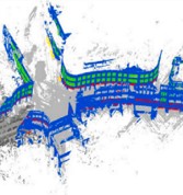
TUM2TWIN: Introducing the large-scale multimodal urban digital twin benchmark dataset
Olaf Wysocki, Benedikt Schwab, Manoj Kumar Biswanath, Michael Greza, Qilin Zhang, Jingwei Zhu, Thomas Froech, Medhini Heeramaglore, Ihab Hijazi, Khaoula Kanna, Mathias Pechinger, Zhaiyu Chen, Yao Sun, Alejandro Rueda Segura, Ziyang Xu, Omar AbdelGafar, Mansour Mehranfar, Chandan Yeshwanth, Yueh-Cheng Liu, Hadi Yazdi, Jiapan Wang, Stefan Auer, Katharina Anders, Klaus Bogenberger, André Borrmann, Angela Dai, Ludwig Hoegner, Christoph Holst, Thomas H. Kolbe, Ferdinand Ludwig, Matthias Nießner, Frank Petzold, Xiao Xiang Zhu, Boris Jutzi
Pages: 810-830

National mapping of wetland vegetation leaf area index in China using hybrid model with Sentinel-2 and Landsat-8 data
Jianing Zhen, Dehua Mao, Yeqiao Wang, Junjie Wang, Chenwei Nie, Shiqi Huo, Hengxing Xiang, Yongxing Ren, Ling Luo, Zongming Wang
Pages: 18-33

Beyond the surface: machine learning uncovers ENSO’s hidden and contrasting impacts on phytoplankton vertical structure
Jing Yang, Yanfeng Wen, Peng Chen, Zhenhua Zhang, Delu Pan
Pages: 890-909

Unveiling spatiotemporal forest cover patterns breaking the cloud barrier: Annual 30  m mapping in cloud-prone southern China from 2000 to 2020
Peng Qin, Huabing Huang, Jie Wang, Yunxia Cui, Peimin Chen, Shuang Chen, Yu Xia, Shuai Yuan, Yumei Li, Xiangyu Liu
Pages: 848-864

A Spatially Masked Adaptive Gated Network for multimodal post-flood water extent mapping using SAR and incomplete multispectral data
Hyunho Lee, Wenwen Li
Pages: 492-508

SmartQSM: a novel quantitative structure model using sparse-convolution-based point cloud contraction for reconstruction and analysis of individual tree architecture
Jie Yang, Huaiqing Zhang, Jinyang Li, Haoyue Yang, Tian Gao, Tingdong Yang, Jiaxin Wang, Xiaoli Zhang, Ting Yun, Yuxin Duanmu, Sihan Chen, Yukai Shi
Pages: 712-739

Urban–rural gradients in cooling efficiency trends of tree covers across global cities
Chunli Wang, Kaiyuan Li, Wenfeng Zhan, Long Li, Chenguang Wang, Shasha Wang, Sida Jiang, Shuang Ge, Zihan Liu
Pages: 210-222

An enhanced spatiotemporal prediction method on landslide displacement with LDP-ConvFormer and MT-InSAR observations
Jianao Cai, Dongping Ming, Feng Liu, Wenyi Zhao, Mingzhi Zhang, Xiao Ling, Mengyuan Zhu, Lu Xu, Tingting Lu, Ningjie Liu, Yanfei Wei, Ming Huang
Pages: 594-612

City-Facade: A city-level large-scale point cloud building facade dataset for semantic & instance segmentation
Yiping Chen, Jonathan Li, Ting Han, Huifang Feng, Jun Chen, Cheng Wang
Pages: 675-688

Improvement of the consistency among long-term global land surface phenology products derived from AVHRR, MODIS, and VIIRS observations
Yongchang Ye, Xiaoyang Zhang, Yu Shen, Khuong H. Tran, Shuai Gao, Yuxia Liu, Shuai An
Pages: 369-388

Beyond synthetic scenarios: Weakly-supervised super-resolution for spatiotemporally misaligned remote sensing images
Quanyi Guo, Rui Liu, Yangtian Fang, Yi Gao, Jun Chen, Xin Tian
Pages: 524-541

Progressive uncertainty-guided network for binary segmentation in high-resolution remote sensing imagery
Jiepan Li, Wei He, Ting Hu, Minghao Tang, Liangpei Zhang
Pages: 561-577

Mapping land uses following tropical deforestation with location-aware deep learning
Jan Pišl, Gencer Sumbul, Gaston Lenczner, Camilo Zamora, Martin Herold, Jan Dirk Wegner, Devis Tuia
Pages: 578-593

Satellite images reveal reduced lake chlorophyll concentration and eutrophication in China
Sijia Li, Xiangming Xiao, Ge Liu, Zhidan Wen, Chong Fang, Yingxin Shang, Hui Tao, Lele Zhang, Yong Li, Qiang Wang, Haoyun Zhou, Kaishan Song
Pages: 353-368

Roof-aware indoor BIM reconstruction from LiDAR via graph-attention for residential buildings
Biao Xiong, Bohan Wang, Yiyi Liu, Liangliang Wang, Yanchao Yang, Liang Zhou, Qiegen Liu
Pages: 408-420

PACE (Plankton, Aerosol, Cloud, ocean Ecosystem): Preliminary analysis of the consistency of remote sensing reflectance product over aquatic systems
Rejane S. Paulino, Vitor S. Martins, Cassia B. Caballero, Thainara M.A. Lima, Bingqing Liu, Akash Ashapure, Jeremy Werdell
Pages: 196-209

Attributing GHG emissions to individual facilities using multi-temporal hyperspectral images: Methodology and applications
Yichi Zhang, Ge Han, Yiyang Huang, Huayi Wang, Hongyuan Zhang, Zhipeng Pei, Yuanxue Pu, Haotian Luo, Jinchun Yi, Tianqi Shi, Siwei Li, Wei Gong
Pages: 937-956

2Player: A general framework for self-supervised change detection via cooperative learning
Manon Béchaz, Emanuele Dalsasso, Ciprian Tomoiagă, Marcin Detyniecki, Devis Tuia
Pages: 34-47

Complex convolutional sparse coding InSAR phase filtering Incorporating directional gradients and second-order difference regularization
Pengcheng Hu, Xu Li, Junhuan Peng, Xu Ma, Yuhan Su, Xiaoman Qi, Xinwei Jiang, Wenwen Wang
Pages: 740-765

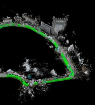
AEOS: Active Environment-aware Optimal Scanning Control for UAV LiDAR-Inertial Odometry in Complex Scenes
Jianping Li, Xinhang Xu, Zhongyuan Liu, Shenghai Yuan, Muqing Cao, Lihua Xie
Pages: 476-491

UrbanMMCL: Urban region representations via multi-modal and multi-graph self-supervised contrastive learning
Jinzhou Cao, Jiashi Chen, Xiangxu Wang, Weiming Huang, Dongsheng Chen, Tianhong Zhao, Wei Tu, Qingquan Li
Pages: 75-93

CityVLM: Towards sustainable urban development via multi-view coordinated vision–language model
Junjue Wang, Weihao Xuan, Heli Qi, Zihang Chen, Hongruixuan Chen, Zhuo Zheng, Junshi Xia, Yanfei Zhong, Naoto Yokoya
Pages: 62-74

Perspectives on spatio-temporal intelligence
Deren Li, Mi Wang, Jing Xiao, Bo Yang
Pages: 305-318

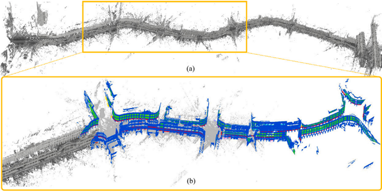
Automated TLS multi-scan registration in forest environments: A novel solution based on hash table
Xiaochen Wang, Xinlian Liang
Pages: 280-304

Crowd detection using Very-Fine-Resolution satellite imagery
Tong Xiao, Qunming Wang, Ping Lu, Tenghai Huang, Xiaohua Tong, Peter M. Atkinson
Pages: 787-809

Mapping oil spills under varying sun glint conditions using a diffusion model with spatial-spectral-frequency constraints
Kai Du, Yi Ma, Zhongwei Li, Rongjie Liu, Zongchen Jiang, Junfang Yang
Pages: 48-61

Uncovering spatial process heterogeneity from graph-based deep spatial regression
Di Zhu, Sheng Wang, Peng Luo
Pages: 509-523

AMS-Former: Adaptive multi-scale transformer for multi-modal image matching
Jiahao Rao, Rui Liu, Jianjun Guan, Xin Tian
Pages: 957-973

MARSNet: A Mamba-driven adaptive framework for robust multisource remote sensing image matching in noisy environments
Weipeng Jing, Peilun Kang, Donglin Di, Jian Wang, Yang Song, Chao Li, Lei Fan
Pages: 457-475

Change tensor: Estimating complex topographic changes from point clouds using Riemann manifold surfaces
Shoujun Jia, Lotte {de Vugt}, Andreas Mayr, Katharina Anders, Chun Liu, Martin Rutzinger
Pages: 766-786

An SW-TES hybrid algorithm for retrieving mountainous land surface temperature from high-resolution thermal infrared remote sensing data
Zhi-Wei He, Bo-Hui Tang, Zhao-Liang Li
Pages: 865-889

Phase gradient rate constrained minimum cost flow: A robust unwrapping method for landslides with large deformation gradients
Xiaosong Feng, Lianhuan Wei, Xu Ren, Chaoying Zhao, Meng Ao, Yian Wang, Jiayin Luo, Christian Bignami
Pages: 437-456

BEDI: a comprehensive benchmark for evaluating embodied agents on UAVs
Mingning Guo, Mengwei Wu, Jiarun He, Shaoxian Li, Haifeng Li, Chao Tao
Pages: 910-936

3D building reconstruction from monocular remote sensing imagery via diffusion models and geometric priors
Zhenghao Hu, Weijia Li, Jinhua Yu, Minfa Liu, Junyan Ye, Peimin Chen, Huabing Huang
Pages: 124-137

DVGBench: Implicit-to-explicit visual grounding benchmark in UAV imagery with large vision–language models
Yue Zhou, Jue Chen, Zilun Zhang, Penghui Huang, Ran Ding, Zhentao Zou, PengFei Gao, Yuchen Wei, Ke Li, Xue Yang, Xue Jiang, Hongxin Yang, Jonathan Li
Pages: 831-847

TFRSUB: A terrain-feature retention and spatial uniformity balancing method for simplifying LiDAR ground point clouds
Chuanfa Chen, Ziming Yang, Hongming Pan, Yanyan Li, Jinda Hao
Pages: 389-407

RSMT: Robust stereo matching training with geometric correction, clean pixel selection and loss weighting
Haoxuan Sun, Taoyang Wang, Qian Cheng, Jiaxuan Huang
Pages: 421-436

High-spatial-resolution gross primary production estimation from Sentinel-2 reflectance using hybrid Gaussian processes modeling
Emma {De Clerck}, Pablo Reyes-Muñoz, Egor Prikaziuk, Dávid D.Kovács, Jochem Verrelst
Pages: 172-195

Mapping melliferous tree species in Kenya via one-class classification with hyperspectral unsupervised domain adaptation
Zhaozhi Luo, Janne Heiskanen, Ilja Vuorinne, Ian Ocholla, Shiqi Zhang, Saana Järvinen, Xinyu Wang, Yanfei Zhong, Petri Pellikka
Pages: 638-655

Enhancing monocular height estimation via sparse LiDAR-guided correction
Jian Song, Hongruixuan Chen, Naoto Yokoya
Pages: 155-171

EnBoT-SORT: Hierarchical fusion-association tracking with pseudo-sample generation for dense thermal infrared UAVs
Jinxin Guo, Weida Zhan, Yu Chen, Depeng Zhu, Yichun Jiang, Xiaoyu Xu, Deng Han
Pages: 138-154

Two-stage offline knowledge distillation for onboard registration of multispectral satellite images
Darshana Priyasad, Tharindu Fernando, Maryam Haghighat, Harshala Gammulle, Roberto {Del Prete}, Clinton Fookes
Pages: 319-335

Cross-satellite hierarchical multimodal denoising for hyperspectral imagery
Minghua Wang, Bo Shang, Yilun Li, Xin Zhao, Lianru Gao, Xu Sun, Longfei Ren
Pages: 94-108

A spectral index using generic global endmembers from Landsat multispectral data for mapping urban areas
Ruiyi Zhao, Cai Cai, Xinfan Cai, Peijun Li
Pages: 613-637

Empowering tree-scale monitoring over large areas: Individual tree delineation from high-resolution imagery
Xinlian Liang, Yinrui Wang, Jun Pan, Janne Heiskanen, Ningning Wang, Siyu Wu, Ilja Vuorinne, Jiaojiao Tian, Jonas Troles, Myriam Cloutier, Stefano Puliti, Aishwarya Chandrasekaran, James Ball, Xiangcheng Mi, Guochun Shen, Kun Song, Guofan Shao, Rasmus Astrup, Yunsheng Wang, Petri Pellikka, Mi Wang, Jianya Gong
Pages: 974-999

Spatial–spectral fusion under highly dynamic ocean conditions based on optical water classification
Changpeng Li, Bangyi Tao, Yunzhou Li, Yan Wang, Yixian Zhu, Renjie Chen, Haiqing Huang, Delu Pan, Hongtao Wang
Pages: 689-711

Synthetic learning for primitive-based building model reconstruction from point clouds
Zhixin Li, Jie Shan
Pages: 336-352

Mamba-CNN hybrid Multi-scale ship detection Network driven by a Dual-perception feature of Doppler and Scattering
Gui Gao, Caiyi Li, Xi Zhang, Bingxiu Yao, Zhen Chen
Pages: 656-674

Towards High spatial resolution and fine-grained fidelity depth reconstruction of single-photon LiDAR with context-aware spatiotemporal modeling
Zhenyu Zhang, Yuan Li, Feihu Zhu, Yuechao Ma, Junying Lv, Qian Sun, Lin Li, Wuming Zhang
Pages: 238-261

Explainable spatiotemporal deep learning for subseasonal super-resolution forecasting of Arctic sea ice concentration during the melting season
Jianxin He, Yuxin Zhao, Shuo Yang, Woping Wu, Jian Wang, Xiong Deng
Pages: 1-17

Physically-constrained flow learning reveals diurnal submesoscale surface currents from geostationary satellite observations
Xiaosong Ding, Xianqiang He, Hemant Khatri, Jiajia Li, Feng Ye, Hao Li, Min Zhao, Fang Gong
Pages: 223-237

Advancing table beet root yield estimation via unmanned aerial systems (UAS) multi-modal sensing
Mohammad S. Saif, Robert Chancia, Sean P. Murphy, Sarah Pethybridge, Jan {van Aardt}
Pages: 542-560


New publications
Volume 233 (March 2026)

Editorial Board
Pages: ii

Minimizing sun glint impacts on Sentinel-2 Sargassum mapping
Junnan Jiao, Chuanmin Hu, Brian B. Barnes
Pages: 651-663

Explainable urban renewal prediction at building-scale using hierarchical graph neural networks
Xiaoqin Yan, Zhou Huang, Shuliang Ren, Qia Zhu, Ganmin Yin, Junnan Qi, Yi Bao
Pages: 609-622

Multimodal remote sensing change detection: An image matching perspective
Hongruixuan Chen, Cuiling Lan, Jian Song, Damian Ibañez, Junshi Xia, Konrad Schindler, Naoto Yokoya
Pages: 487-501

Gait-Aware quadruped 3D mapping in challenging environments with complex terrain
Xinge Zhao, Xing Zhang, Yiqing Ni, Qingquan Li, Wentao Zeng, Haixia Feng, Yibo Zhou
Pages: 664-688

Multispectral airborne laser scanning for tree species classification: A benchmark of machine learning and deep learning algorithms
Josef Taher, Eric Hyyppä, Matti Hyyppä, Klaara Salolahti, Xiaowei Yu, Leena Matikainen, Antero Kukko, Matti Lehtomäki, Harri Kaartinen, Sopitta Thurachen, Paula Litkey, Ville Luoma, Markus Holopainen, Gefei Kong, Hongchao Fan, Petri Rönnholm, Matti Vaaja, Antti Polvivaara, Samuli Junttila, Mikko Vastaranta, Stefano Puliti, Rasmus Astrup, Joel Kostensalo, Mari Myllymäki, Maksymilian Kulicki, Krzysztof Stereńczak, Raul de Paula Pires, Ruben Valbuena, Juan Pedro Carbonell-Rivera, Jesús Torralba, Yi-Chen Chen, Lukas Winiwarter, Markus Hollaus, Gottfried Mandlburger, Narges Takhtkeshha, Fabio Remondino, Maciej Lisiewicz, Bartłomiej Kraszewski, Xinlian Liang, Jianchang Chen, Eero Ahokas, Kirsi Karila, Eugeniu Vezeteu, Petri Manninen, Roope Näsi, Heikki Hyyti, Siiri Pyykkönen, Peilun Hu, Juha Hyyppä
Pages: 278-309

SuperMapNet for long-range and high-accuracy vectorized HD map construction
Ruqin Zhou, Chenguang Dai, Wanshou Jiang, Yongsheng Zhang, Zhenchao Zhang, San Jiang
Pages: 89-103

Set-CVGL: A new perspective on cross-view geo-localization with unordered ground-view image sets
Qiong Wu, Panwang Xia, Lei Yu, Yi Liu, Mingtao Xiong, Liheng Zhong, Jingdong Chen, Ming Yang, Yongjun Zhang, Yi Wan
Pages: 328-345

Harnessing conditional generative adversarial networks for SAR-to-optical image translation via auxiliary geospatial landscape pattern-augmentation
Hongbo Liang, Xuezhi Yang, Xiangyu Yang, Xin Jing
Pages: 502-518

Monitoring global power outages induced by tropical cyclones using nighttime light data
Liujun Zhu, Yaqian Li, Shanshui Yuan, Shi Shi, Fang Ji
Pages: 437-451

Knowledge distillation with spatial semantic enhancement for remote sensing object detection
Kai Hu, Jiaxin Li, Nan Ji, Xueshang Xiang, Kai Jiang, Xieping Gao
Pages: 144-157

An advanced decoupled polarimetric calibration method for the LuTan-1 hybrid- and quadrature-polarimetric modes
Lizhi Liu, Lijie Huang, Yidi Wang, Pingping Lu, Bo Li, Liang Li, Robert Wang, Yirong Wu
Pages: 310-327

A geometric Cross-Propagation-Calibration method for SAR constellation based on the graph theory
Yitong Luo, Xiaolan Qiu, Bei Lin, Zekun Jiao, Wei Wang, Chibiao Ding
Pages: 346-359

PANet: A multi-scale temporal decoupling network and its high-resolution benchmark dataset for detecting pseudo changes in cropland non-agriculturalization
Songman Sui, Jixian Zhang, Haiyan Gu, Yue Chang
Pages: 126-143

A near-real-time multi-temporal polarimetric InSAR method for landslides monitoring in rapid-decorrelation scenarios
Yaogang Chen, Jun Hu, Jordi J. Mallorqui, Haiqiang Fu, Wanji Zheng, Aoqing Guo
Pages: 556-574

Identifying green leaf and leaf phenology of large trees and forests by time series PlanetScope and Sentinel-2 images and the chlorophyll and green leaf indicator (CGLI)
Baihong Pan, Xiangming Xiao, Li Pan, Andrew D Richardson, Yujie Liu, Yuan Yao, Cheng Meng, Yanhua Xie, Chenchen Zhang, Yuanwei Qin
Pages: 104-125

Estimation of global riverine total phosphorus concentration based on multi-source data and stacked ensemble learning
Qi Li, Lan Zhang, Xi Chen, Chen Zhang, Jingyi Tian, Xianghan Sun, Liqiao Tian
Pages: 588-608

AnchorReF: A novel anchor-based visual re-localization framework aided by multi-sensor data fusion
Hao Wu, Yu Ran, Xiaoxiang Zhang, Xinying Luo, Li Wang, Teng Zhao, Yongcheng Song, Zhijun Zhang, Huisong Zhang, Jin Liu, Jian Li
Pages: 1-13

VectorLLM: Human-like extraction of structured building contours via multimodal LLMs
Tao Zhang, Shiqing Wei, Shihao Chen, Wenling Yu, Muying Luo, Shunping Ji
Pages: 55-68

WHU-STree: A multi-modal benchmark dataset for street tree inventory
Ruifei Ding, Zhe Chen, Wen Fan, Chen Long, Huijuan Xiao, Yelu Zeng, Zhen Dong, Bisheng Yang
Pages: 519-542

Monitoring snow cover dynamics at 30-m resolution in higher latitude regions using Harmonized Landsat Sentinel-2
Mitchell T. Bonney, Yu Zhang
Pages: 360-382

EAV-DETR: Efficient Arbitrary-View oriented object detection with probabilistic guarantees for UAV imagery
Haoyu Zuo, Minghao Ning, Yiming Shu, Shucheng Huang, Chen Sun
Pages: 575-587

Weak supervision makes strong details: fine-grained object recognition in remote sensing images via regional diffusion with VLM
Liuqian Wang, Jing Zhang, Guangming Mi, Li Zhuo
Pages: 231-246

A weakly supervised approach for large-scale agricultural parcel extraction from VHR imagery via foundation models and adaptive noise correction
Wenpeng Zhao, Shanchuan Guo, Xueliang Zhang, Pengfei Tang, Xiaoquan Pan, Haowei Mu, Chenghan Yang, Zilong Xia, Zheng Wang, Jun Du, Peijun Du
Pages: 180-208

Multi-object tracking of vehicles and anomalous states in remote sensing videos: Joint learning of historical trajectory guidance and ID prediction
Bin Wang, Yuan Zhou, Haigang Sui, Guorui Ma, Peng Cheng, Di Wang
Pages: 383-406

Knowledge-data-model-driven multimodal few-shot learning for hyperspectral fine classification: Generalization across sensor, category and scene
Qiqi Zhu, Mingzhen Xu, Rui Ma, Longli Ran, Jiayao Xue, Qingfeng Guan
Pages: 623-650

RECREATE: Supervised contrastive learning and inpainting based hyperspectral image denoising
Aditya Dixit, Anup Kumar Gupta, Puneet Gupta, Ankur Garg
Pages: 14-24

A novel transformer-based CO2 retrieval framework incorporating prior constraint and hierarchical features injection: assessment of transferability for Tansat-2
Lingfeng Zhang, Lu Zhang, Xingying Zhang, Tiantao Cheng, Xifeng Cao, Tongwen Li, Dongdong Liu, Yang Zhang, Yuhan Jiang, Ruohua Hu, Haiyang Dou, Lin Chen
Pages: 423-436

Adaptive image zoom-in with bounding box transformation for UAV object detection
Tao Wang, Chenyu Lin, Chenwei Tang, Jizhe Zhou, Deng Xiong, Jianan Li, Jian Zhao, Jiancheng Lv
Pages: 452-466

RTPSeg: A multi-modality dataset for LiDAR point cloud semantic segmentation assisted with RGB-thermal images in autonomous driving
Yifan Sun, Chenguang Dai, Wenke Li, Xinpu Liu, Yongqi Sun, Ye Zhang, Weijun Guan, Yongsheng Zhang, Yulan Guo, Hanyun Wang
Pages: 25-38

WEGLA-NormGAN: wavelet-enhanced Cycle-GAN with global-local attention for radiometric normalization of remote sensing images
Wenxia Gan, Yu Feng, Jianhao Miao, Xinghua Li, Huanfeng Shen
Pages: 39-54

RegScorer: Learning to select the best transformation of point cloud registration
Xiaochen Yang, Haiping Wang, Yuan Liu, Bisheng Yang, Zhen Dong
Pages: 266-277

Roadside lidar-based scene understanding toward intelligent traffic perception: A comprehensive review
Jiaxing Zhang, Chengjun Ge, Wen Xiao, Miao Tang, Jon Mills, Benjamin Coifman, Nengcheng Chen
Pages: 69-88

MMP-Mapper: Multi-modal priors enhancing vectorized HD road map construction from aerial imagery
Haofeng Xie, Huiwei Jiang, Yandi Yang, Xiangyun Hu
Pages: 543-555

Varying sensitivities of RED-NIR-based vegetation indices to the input reflectance affect the detected long-term trends
Qing Tian, Hongxiao Jin, Rasmus Fensholt, Torbern Tagesson, Luwei Feng, Feng Tian
Pages: 247-265

L2M-Reg: Building-level uncertainty-aware registration of outdoor LiDAR point clouds and semantic 3D city models
Ziyang Xu, Benedikt Schwab, Yihui Yang, Thomas H. Kolbe, Christoph Holst
Pages: 467-486

Detecting global ocean subsurface density change with high-resolution via dual-task densely-former
Hua Su, Weiqi Xie, Luping You, Sihui Li, Dian Lin, An Wang
Pages: 158-179

Comparative assessment of AI-based and classical DSAS approaches in multi-temporal shoreline prediction: A case study of Ras El-Bar coast, Egypt
Hesham M. El-Asmar, Mahmoud Sh. Felfla
Pages: 407-422

Satellite-based heat Index estimatioN modEl (SHINE): An integrated machine learning approach for the conterminous United States
Seyed Babak {Haji Seyed Asadollah}, Giorgos Mountrakis, Stephen B. Shaw
Pages: 209-230


New publications
Volume 234 (April 2026)

Editorial Board
Pages: ii

Mapping snow algae in West Antarctic Peninsula from Sentinel-2 images using a machine learning based approach
Yuxuan Li, Xuchao Yang, Wei Luo, Chengfeng Le
Pages: 275-290

Towards operational tracking of weekly crop progress using VIIRS land surface phenology product across the continental United States
Naeem Abbas Malik, Xiaoyang Zhang, Yu Shen, Zhengwei Yang, Yongchang Ye, Yuxia Liu
Pages: 337-354

Spatiotemporal score-based federated generative learning for multi-source remote sensing time series in environmental monitoring
Shagufta Henna, Upaka Rathnayake
Pages: 386-404

TLNet: A deep learning framework for tree detection in forest point clouds using multi-layered forest structure
Yiliu Tan, Xin Yang, Jingyi Zhang, Xin Xu, Yunjian Cao, Di Wang, Maiko Shigeno
Pages: 227-241

Neural network based on high freedom dynamic collaboration of flows for meteorological data temporal downscaling
Junkai Wang, Yu Zhang, Shuangrui Liu, Lianlei Lin, Qiong Li, Zongwei Zhang, Hanqing Zhao, Hangyi Yu, Yupu Yang
Pages: 170-184

SpecAware: a spectral-content aware foundation model for unifying multi-sensor learning in hyperspectral remote sensing mapping
Renjie Ji, Xue Wang, Chao Niu, Wen Zhang, Yong Mei, Kun Tan
Pages: 242-260

Predictability of Earth’s greenness
Wen Zhuo, Shibo Fang, Xinran Gao, Taejin Park, Zaichun Zhu, Zilong Zhong, Jose D. Bermudez, Alemu Gonsamo
Pages: 355-368

Heterogeneous graph neural networks for building attribute prediction from hierarchical urban features and cross-view imagery
Xiucheng Liang, Winston Yap, Filip Biljecki
Pages: 185-204

Mapping three decades of forest structural changes in Japan using Landsat time series and airborne LiDAR data
Katsuto Shimizu, Hideki Saito, Tomohiro Nishizono, Yusuke Yamada, Fumiaki Kitahara
Pages: 111-133

Epistemic and aleatoric uncertainty in optical vegetation trait retrieval: Concepts, Methods, and Outlook
Jochem Verrelst, José Luis García-Soria, Pablo Reyes-Muñoz, Emma {De Clerck}, Miguel Morata, Juan Pablo Rivera-Caicedo
Pages: 20-45

Corrigendum to “SmartQSM: a novel quantitative structure model using sparse-convolution-based point cloud contraction for reconstruction and analysis of individual tree architecture” [ISPRS J. Photogramm. Remote Sens. 232 (2026), 712–739]
Jie Yang, Huaiqing Zhang, Jinyang Li, Haoyue Yang, Tian Gao, Tingdong Yang, Jiaxin Wang, Xiaoli Zhang, Ting Yun, Yuxin Duanmu, Sihan Chen, Yukai Sh
Pages: 167-169

Towards automated laser triangulation with stereo and planar constraints in refractive environments
Robin Rofallski, Thomas Luhmann
Pages: 307-321

Surface reflectance in homogeneous regions follows a Gamma distribution: principles, validation and applications
Yuanhong Liao, Yuqi Bai, Yanping You, Jie Wang, Shuang Chen, Ming Lin, Jin Chen, Jing M. Chen, Bing Xu, Peng Gong
Pages: 72-92

Global mapping of tidal wetlands and adjacent environments using tidal analysis and multi-source Earth observations
Miao Li, Thomas Worthington, Bin Chen, Lindsey Smart, Mark Spalding, Tao Zhang, Sayam U. Chowdhury, Yuqi Bai, Dongmei Yan, Suju Li, Bing Xu
Pages: 293-306

Enhanced remote sensing of surface water Chlorophyll-a: Coupling dynamic algae vertical movement modeling with multi-spectral satellite images
Shengxi Gui, Kaiden A. Murphy, Mark A. Tischer, Linda K. Weavers, Rongjun Qin
Pages: 205-226

Spatiotemporal CNN framework for quantifying crop-specific salinity damage in coastal agriculture
Chenli Xue, Aurora Ghirardelli, Jianping Chen, Paolo Tarolli
Pages: 322-336

KGBDCNet: keyword-guided building damage captioning network for bi-temporal remote sensing images
Di Wang, Guorui Ma, Xiao Wang, Yongxian Zhang, Haiming Zhang, Bin Wang, Peng Chen
Pages: 369-385

STNet: A spatio-temporal network for binary change detection in high-resolution remote sensing images
Chen Lu, Han Xu, Xian Zhang, Guangcan Liu
Pages: 60-71

Label-efficient outdoor 3D object detection via single click annotation from LiDAR point cloud
Qiming Xia, Hongwei Lin, Wei Ye, Yadan Luo, Shijia Zhao, Hai Wu, Chenglu Wen, Cheng Wang
Pages: 151-166

Quantitative comparison of fine-tuning techniques for pretrained latent diffusion models in the generation of unseen SAR images
Solène Debuysère, Nicolas Trouvé, Nathan Letheule, Olivier Lévêque, Elise Colin
Pages: 93-110

Corrigendum to “Multispectral airborne laser scanning for tree species classification: A benchmark of machine learning and deep learning algorithms” [ISPRS J. Photogramm. Remote Sens. 233 (2026) 278–309]
Josef Taher, Eric Hyyppä, Matti Hyyppä, Klaara Salolahti, Xiaowei Yu, Leena Matikainen, Antero Kukko, Matti Lehtomäki, Harri Kaartinen, Sopitta Thurachen, Paula Litkey, Ville Luoma, Markus Holopainen, Gefei Kong, Hongchao Fan, Petri Rönnholm, Matti Vaaja, Antti Polvivaara, Samuli Junttila, Mikko Vastaranta, Stefano Puliti, Rasmus Astrup, Joel Kostensalo, Mari Myllymäki, Maksymilian Kulicki, Krzysztof Stereńczak, Raul {de Paula Pires}, Ruben Valbuena, Juan Pedro Carbonell-Rivera, Jesús Torralba, Yi-Chen Chen, Lukas Winiwarter, Markus Hollaus, Gottfried Mandlburger, Narges Takhtkeshha, Fabio Remondino, Maciej Lisiewicz, Bartłomiej Kraszewski, Xinlian Liang, Jianchang Chen, Eero Ahokas, Kirsi Karila, Eugeniu Vezeteu, Petri Manninen, Roope Näsi, Heikki Hyyti, Siiri Pyykkönen, Peilun Hu, Juha Hyypp
Pages: 291-292

Integrating spatiotemporal similarity for robust gap-filling in continuous surface water mapping with uncertainty quantification
Zhen Xiao, Runkui Li, Xianfeng Song, Mingjun Ding, Shunlin Liang
Pages: 134-150

SP-KAN: Sparse-sine perception Kolmogorov–Arnold networks for infrared small target detection
Shuai Yuan, Yu Liu, Xiaopei Zhang, Xiang Yan, Hanlin Qin, Naveed Akhtar
Pages: 1-19

RoofX-Net: A tailored approach to accurate multi-type rooftop segmentation in remote sensing images using edge and scale awareness
Keyu Chen, Tianlei Wang, Zhiyou Yang, Fan Li, Ma Luo, Ruoning Zhang, Hong Qu, Wenyu Chen
Pages: 46-59

Automatic tree-level based forest inventories retrieval via ultra-high resolution UAV images and deep learning
Wen Fan, Thomas Knoke, Jonas Troles, Jiaojiao Tian
Pages: 261-274


New publications
Volume 235 (May 2026)

Editorial Board
Pages: ii

How does missing-modality affect cross-domain remote sensing image classification: A synergistic inter-modal proxy fine-tuning solution
Aijun Xu, Zhaohui Xue, Hao Wu
Pages: 153-170

GaussianCraft: Fine-grained 3D Gaussians for efficient large-scene surface reconstruction
Hanyu Xiang, Fan Zhang, Xiaokai Li, Chong Yang, Yunlong Gao, Wenxuan Liu, Lei Zhao, Deren Li, Xianfeng Huang
Pages: 651-667

A semi-supervised deep learning framework based on multi-source data for wheat: from counting to yield estimation
Qing Geng, Xin Xu, Xinming Ma, Fan Xu, Jiayue Yu, Xiaoqiang Yang, Yupeng Deng, Diyou Liu, Li Li, Bingbo Gao, Yu Meng, Jianyu Yang, Jianxi Huang, Xiaochuang Yao
Pages: 445-469

GeoSight v2: strengthening disaster impact assessment with coordinate referencing, inpainting, and similarity models
Jooho Kim, J.V.K. Chaitanya
Pages: 634-650

Material proportion guided hyperspectral image super-resolution via unmixing
Yinghao Xu, Xuanwen Tao, Zihao Ni, Zonghua Liu, Yimin Fu, Peng Ren
Pages: 584-598

Close-range real-time camera pose estimation and AR-guided alignment for large-scale industrial components
Francesco Messina, Alessio Martino, Francesca Matrone, Andrea Maria Lingua, Pablo Puerto
Pages: 58-71

MSENet: multi-task synergistic enhancement network for 3D building instance change detection
Wenxiao Zhan, Jing Chen
Pages: 279-296

Lightweight and adaptive fusion framework using remote sensing derived scene backbone map for positioning enhancement in urban NLOS environments
Zhenqi Zheng, Xiao Sun, Xuan Wang, Qiyu Zhang, Bisheng Yang, You Li
Pages: 297-317

A spherical-harmonic deep learning framework for generic tree morphology and species identification
Kang Jiang, Ting Yun, Qihao Weng
Pages: 599-617

Partial points segmenter: A unified framework for partially category-supervised point cloud segmentation
Shuyu Zhang, Wenzhong Shi, Shengyu Lu, Daping Yang
Pages: 211-223

DOMapping: Multi-UAV real-time DOM mapping with local-to-global optimization
Li Tang, Hongqi Jin, Yan Zhou, Xiaoping Liu
Pages: 565-583

Estimating tree mortality timing using PlanetScope satellite image time series
Jesse Nowak, Markus Holopainen, Teja Kattenborn, Samuli Junttila
Pages: 261-278

Ultra-high-resolution SAR and optical image registration: From global benchmark dataset to frequency-guided registration method
Heng Yan, Ailong Ma, Hong Shu, Yuting Wan, Liangpei Zhang, Yanfei Zhong
Pages: 190-210

DHT-SWNet: Frequency-aware ship and wake detection in multi-source optical remote sensing imagery
Jiaze Zhang, Baoxiang Huang, Ge Chen, Linyao Ge, Linghui Xia, Xinmin Zhang
Pages: 399-415

Glance-Focus-Gaze: A novel Eagle-Eye Vision-Inspired Panorama-Population-Individual progressive screening paradigm to capture ships in SAR images
Tianwen Zhang, Gui Gao, Xiaoling Zhang
Pages: 241-260

Efficient feature matching for UAV images based on compact GPU data scheduling
San Jiang, Kan You, Ruqin Zhou, Xing Zhang, Zhijun Wang, Qingquan Li
Pages: 224-240

Efficient multi-objective dynamic programming for building mesh optimization with 3D lines
Xiaotong Li, Dong Wei, Yongjun Zhang, Yi Wan, Haoyu Guo, Guangshuai Wang
Pages: 171-189

A soybean mapping framework via multi-index-derived pseudo-label enhancement and contrastive embedding neural network
Tianyu Liu, Kai Tang, Yunze Zang, Anqi Li, Xuehong Chen, Peng Yang, Lang Xia, Youzhi Zhang, Bingwen Qiu, Jin Chen
Pages: 38-57

Causally regularized full-resolution channel attention and frequency refinement for cloud removal in satellite imagery
Jun Wang, Xinhao Xu, Changqing Lin, Feng Wang
Pages: 133-152

Angular normalization of solar-induced chlorophyll fluorescence on tree crown scale for red and near-infrared bands based on multi-angle UAV observations
Zhiqiang Cheng, Jing M. Chen, Chunyu Lai, Hongda Zeng, Guofang Miao, Zhiqun Huang
Pages: 383-398

Railway track surface defect 3D reconstruction and relocalisation through cross-modality fusion
Yizhong Wang, Lichao Yang, Isidro D. Cardenas, Yifan Zhao
Pages: 618-633

Remote sensing image dehazing: A systematic review of progress, challenges, and prospects
Heng Zhou, Xiaoxiong Liu, Zhenxi Zhang, Jieheng Yun, Chengyang Li, Yunchu Yang, Dongyi Xia, Chunna Tian, Xiao-Jun Wu
Pages: 318-348

Unifying semantic segmentation and change detection in urban villages: The ZY-UV benchmark and MutualTemp framework
Xueting Zhang, Xin Huang
Pages: 470-487

Label-free mangrove mapping from temporally consistent PlanetScope imagery with interpretable deep unfolding network
Xiangyu Nie, Zhaohui Xue, Xiaofeng Li
Pages: 19-37

SuperSTF: A latent diffusion model for cloud-free spatiotemporal remote sensing image fusion
Min Zhao, Jiajun Cai, Man Zhou, Bo Huang
Pages: 1-18

Suspended sediment decline intensified riverbank erosion and collapse in the Yangtze river mainstream
Zhenyu Guo, Kebing Chen, Xuejiao Hou, Lian Feng, Lingling Zhu
Pages: 428-444

LiDAR remote sensing meets weak supervision: Concepts, methods, and perspectives
Yuan Gao, Shaobo Xia, Pu Wang, Xiaohuan Xi, Sheng Nie, Cheng Wang
Pages: 72-104

A geographically weighted XGBoost framework for Pixel-Level modeling of vegetation responses using Multi-Source Earth Observation data
Younes Khosravi, Taha B.M.J. Ouarda
Pages: 105-132

From canopy to ground via ForestGen3D: Learning cross-domain generation of 3D forest structure from aerial-to-terrestrial LiDAR
Juan Castorena, E. Louise Loudermilk, Scott Pokswinski, Rodman Linn
Pages: 363-382

Towards robust disparity estimation in satellite stereo imagery: a new high-quality benchmark dataset and a metadata-informed multi-range geometric encoding network
Guangbin Zhang, Yonghua Jiang, Shaodong Wei, Xin Shen, Kaiwen Wu
Pages: 511-535

Leveraging “SWOT and a-priori information (SWAP)” constrained channel parameters for improved historical river discharge estimates from space
Jie Xu, Zimin Yuan, Yue Xu, Peirong Lin
Pages: 536-550

Multi-granularity Prompt Learning with vision-language model for few-shot remote sensing image scene classification
Tianyang Zhang, Linpan Xu, Xiangrong Zhang, Xiao Han, Jin Zhu, Lianchao Zhang, Guanchun Wang, Licheng Jiao
Pages: 349-362

Cross-modal distillation for real-time wildfire detection and localization in edge-deployed aerial vehicles
Medhavi Mishra, Sumit Mishra, Hyo-Sang Shin
Pages: 551-564

CDEHAT: Conditional Diffusion-Assisted Enhanced Hybrid Attention Transformer for remote sensing imagery super-resolution
Xiande Wu, Rui Liu, Wei Wu, Haiping Yang, Liao Yang
Pages: 488-510

SGCA: A Scribble-Guided Cross-Attention framework for multimodal remote sensing change detection
Yongjie Zheng, Hao Liu, Houcai Guo, Sicong Liu, Lorenzo Bruzzone
Pages: 416-427


ISPRS Open Journal of Photogrammetry and Remote Sensing


ISPRS Open Journal of Photogrammetry and Remote Sensing ISPRS Open Journal of Photogrammetry and Remote Sensing

New publications
Volume 19 (January 2026)

Benchmarking for practice: Few-shot time-series crop-type classification on the EuroCropsML dataset
Joana Reuss, Jan Macdonald, Simon Becker, Ekaterina Gikalo, Konrad Schultka, Lorenz Richter, Marco Körner
Article: 100117

GAST: A graph-augmented spectral–spatial transformer with adaptive gated fusion for small-sample hyperspectral image classification
Faruk Keskin, Fesih Keskin, Gültekin Işık
Article: 100116

Transformer-driven monocular high-resolution DTM generation on mars via multimodal integration of CaSSIS imagery and MOLA altimetry
Riccardo {La Grassa}, Cristina Re, Adriano Tullo, Ignazio Gallo, Gabriele Cremonese
Article: 100118

Accuracy analysis and improvement of worldwide elevation models by ICESat-2 data
Karsten Jacobsen, Gürcan Büyüksalih, Cem Gazioglu
Article: 100115

Map2ImLas: Large-scale 2D-3D airborne dataset with map-based annotations
Geethanjali Anjanappa, Sander Oude Elberink, Abhisek Maiti, Yaping Lin, George Vosselman
Article: 100112

Monitoring tropical forests with light drones: ensuring spatial and temporal consistency in stereophotogrammetric products
Nicolas Barbier, Pierre Ploton, Hadrien Tulet, Gaëlle Viennois, Hugo Leblanc, Benoît Burban, Maxime Réjou-Méchain, Philippe Verley, James Ball, Denis Feurer, Grégoire Vincent
Article: 100114

Feature-based multi-epoch rock slope monitoring using images and terrestrial laser scans
Lukas Lucks, Christoph Holst
Article: 100120

Enhancing point cloud semantic segmentation via scalable domain adaptation with LoRA-enabled PointNet++
Mariona Carós, Ariadna Just, Santi Seguí, Jordi Vitrià
Article: 100119

Continental-scale computer vision models reveal generalizable patterns and pitfalls for urban tree inventories with street-view images
Thomas A. Lake, Brit B. Laginhas, Brennen T. Farrell, Ross K. Meentemeyer, Chris M. Jones
Article: 100122

Achieving higher-resolution visible/near-infrared hyperspectral surface composition on Mars through cross-instrument CRISM-CaSSIS pansharpening
Adriano Tullo, Beatrice Baschetti, Cristina Re, Sylvain Douté, Livio Leonardo Tornabene, Cristian Carli, Angelo Zinzi, Vidhya Ganesh Rangarajan, Silvia Bertoli, Riccardo {La Grassa}, Giovanni Munaretto, Natalia Amanda {Vergara Sassarini}, Matteo Massironi, Gianrico Filacchione, Gabriele Cremonese, Nicolas Thomas
Article: 100121


New Events


01 Jan - 31 Jul 2026
RSDIP 2026
The 2026 International Contest on Remote Sensing Data Intelligent Processing
http://rsipac.whu.edu.cn/index?lang=en_US
Wuhan, China
 

01 Jan - 30 Nov 2026
The 2026 International Student Competition on Digital Architectural Design
http://brauic.bucea.edu.cn/
Beijing, China
 

16-18 Feb 2026
Geo Week 2026
https://www.geo-week.com/
Denver, CO, USA
 

27-29 Apr 2026
12th International Conference on Remote Sensing and Geoinformation of Environment
https://rscy2026.com/
Paphos, Cyprus
 

04-08 May 2026
ForestSAT 2026
Association of Forest Spatial Analysis Technologies
https://carlos-alberto-silva.github.io/silvalab/ForestSAT2026/
Gainesville, Florida, USA
 

13-15 May 2026
RAST 2026
11th International Conference on Recent Advances in Space Technologies
https://rast.org.tr/
Istanbul, Türkiye
 

01-03 Jul 2026
ICERS
International Conference of Environmental Remote Sensing and GIS
https://alcar.geof.hr/icers-conference/
Zagreb, Croatia
 

04-13 Jul 2026
SGEM 2026
26th International Multidisciplinary Scientific GeoConference
https://www.sgem.org
Albena, Bulgaria
 

30 Aug - 05 Sep 2026
FOSS4G 2026 Academic Trac
https://2026.foss4g.org/
Hiroshima, Japan
 

01-03 Sep 2026
Commercial UAV Expo
https://www.expouav.com/
Las Vegas, USA
 

21-25 Sep 2026
AGSE 2026
The challenge of climate change – possible contributions of geoinformation
https://applied-geoinformatics.org/
Kumasi, Ghana
 

22-23 Oct 2026
PHEDCS 2026, ALMATY
Geospatial Technologies, Photogrammetry and Remote Sensing for Sustainable Development in Environmental, Mining and Industrial Applications
https://www.phedcs.com/
Almaty, Kazakhstan
 

23-27 Nov 2026
WLF7
The 7th World Landslide Forum
https://www.wlf7.org
Faridabad, India
 

» See more

Updated Events


28 Sep - 02 Oct 2026
3D GeoInfo | Smart Data Smart Cities | LADM & 3D
https://conference.gate-ai.eu/GeoSofia2026
Sofia, Bulgaria
 

» See more

 
© ISPRS, 2026.
Imprint