 |
| |
| |
 |
|
ISPRS e-Bulletin
Issue No 5 - 2018
|
 |
| |
|
|
Quick Links
|
|
| |
|
Editorial


|
|
ISPRS Student Consortium
by Student Consortium Chair
Sheryl Rose Reyes

“I urge you to stay in the path you’ve chosen and to travel on it as far as you can. The world needs you - badly.”
Those were the words from Dr. Edward O. Wilson’s book, Letters to a Young Scientist. As a student or a young professional, we often find ourselves questioning if we should be following our passion or if it is enough to trust our capabilities to lead the way. This difficult situation is not exclusive – deciding which path to take is one of life’s biggest challenges and often, it is much harder to keep up and stay on the chosen path. But sometimes, all it takes is to find a place where you can meet people with the same experiences and learn from them, to be inspired by other people’s work and to realize that there are opportunities out there.
For more than a decade, the ISPRS Student Consortium (ISPRS SC) has been organizing different activities to engage youth and to provide various opportunities for capacity building and establishing social and professional networks. The ISPRS SC continues the pursuit of fostering the younger generation, who are the future of ISPRS. It has been serving as a platform of exchange among students, researchers, professionals, and experts in the field of remote sensing, photogrammetry, and spatial information science.
The ISPRS SC has realized that we now live in a dynamic and technology-driven world, resulting to the changing needs of the younger generation and their desire to keep up with the most recent trends in different fields of expertise. A future of collaboration and cooperation among various disciplines is now beginning to unfold and it challenges our creativity and resourcefulness, as well as our capabilities to step out of our comfort zone and find the courage to reach out and work with others beyond the limits of our profession. Our digital and fast-paced environment offers possibilities enabling multidisciplinary and trans-disciplinary research and amazing advancements in the industry.
This year, the ISPRS SC has started to broaden its perspectives, beginning with the repackaging of the Newsletter, branding it under the name SpeCtrum – exploring the role of geospatial information and technology in different fields and applications. Four summer schools were organized this year, reaching out to some 200 students and young professionals across the globe. We also partnered with Thailand’s Geo-informatics and Space Technology Development Agency (GISTDA) and the ASEAN Research and Training Center for Space Technology and Applications (ARTSA) to organize and host MOTIVATE Learning: Making Opportunities To Initiate Valuable Alliance Through Experiential Learning. The event, which is part of the ISPRS Education and Capacity Building Initiatives, featured an upgraded version of the Summer School + Hackathon, where 20 participants showcased innovative ideas, and the Spatial Exchange Program, which pioneered the organization’s program in involving participants in international research under the guidance of mentors from renowned organizations. Last September, the Webinar series was finally launched with an introduction to the state-of-the-art geospatial processing platform, Google Earth Engine.
The ISPRS SC hopes to continue working on activities that will encourage youth to get involved and to create more opportunities for experiencing learning in a comfortable and nurturing environment. The support of the ISPRS Council and the generosity of experts, professors and researchers in sharing their valuable time and knowledge to our community have enabled the ISPRS SC to expand its horizons and develop new ideas. We are continually looking for individuals keen to serve and who are willing to share their time and skills with the organization, with an enthusiasm to learn more about teamwork, coordination, and leadership. Get connected with us and visit the ISPRS SC website: sc.isprs.org.
|

|
|
The ISPRS Geospatial Week 2019 is open for paper submission
10-14 June 2019, Enschede, the Netherlands
by George Vosselman
Geospatial Week Director |
|

|
I would like to inform you that the ISPRS Geospatial Week 2019 has been opened for paper submission. After creation of an account on the ConfTool website of the Geospatial Week, authors can submit either a full paper or an extended abstract to one of the following 13 workshops:
- International Conference on Unmanned Aerial Vehicles in Geomatics (UAV-g)
- Laser scanning
- International Symposium on Spatial Data Quality (ISSDQ)
- Indoor 3D
- Advanced Geospatial Applications for Smart Cities and Regions (SmartGeoApps)
- Semantic Scene Analysis and 3D Reconstruction from Images and Image Sequences (Semantics3D)
- International Workshop on Advances in SAR: Constellations, Signal processing, and Applications (SarCon)
- Workshop on Collaborative Crowdsourced Cloud Mapping and Geospatial Big Data (C3M&GBD)
- Joint European Calibration and Orientation Workshop and Workshop on Multi-sensor Systems for 3D Mapping and Navigation (EuroCOW-M3DMaN)
- Hyperspectral Sensing meets Machine Learning and Pattern Analysis (HyperMLPA)
- International Workshop on Image and Data Fusion (IWIDF)
- Workshop on Planetary Remote Sensing and Mapping (PRSM)
- Workshop on Cryosphere and Hydrosphere for Global Change Studies (CHGCS)
Full papers accepted after the review process organised by the workshop convenors will be published in the ISPRS Annals. Authors of accepted extended abstracts (around 1000 words) will be invited to submit their full paper in a later stage for publication in the ISPRS Archives. The deadline for full paper submission is 17 January. The deadline for abstract submission is 4 February. All important dates, author guidelines, and information on the reviewing procedure can be found on the Geospatial Week website through the Participate! menu.
Information on tutorials, to be held on Sunday 9 June, and hotels will be published shortly.
We’re looking forward to your participation in the ISPRS Geospatial Week 2019!
|
|
|
| |
|
The ISPRS Foundation (TIF) News
|
 |
|
TIF Activities 2018 - Travel Grants to Midterm Symposia I to V
With the final 2018 Technical Commission Symposium (TC V) in Dehradun, India, the last of the 2018 travel grants were extended to recipients. TIF, together with ISPRS, is most pleased to publish the following reports from grant recipients:
- Report on Experiences at ISPRS TC I Symposium - Karlsruhe, Germany
by Camilo Cortes
- TIF Travel Grant Report - ISPRS TC I Midterm Symposium - Innovative Sensing - From Sensors to Methods and Applications
by Renato César dos Santos
- Report on the experiences of attending at the ISPRS Technical Commission I Symposium
by André Caceres Carrilho
- Report on experiences at Commission II Symposium
by Fengman Jia
- Travel Grant to attend the ISPRS Technical Commission III Symposium on Developments, Technologies and Applications in Remote Sensing
by Elbegjargal Nasanbat
- Report on the ISPRS Foundation Travel Grant
by Kugler Zsófia
- The ISPRS Symposium 2018 Experience
by Alvin B. Baloloy
- Report on experiences & benefits at ISPRS Technical Commission IV Symposium 2018 “Towards 3D Spatial Information Science” in Tu Delft, The Netherlands
October 1-5, 2018
by Inder Mohan Chauhan
- Report of Participation, TC V Midterm Symposium - Geospatial Technology - Pixel to People, Dehradun, India: November 20-23, 2018
by Hilcéa Santos Ferreira
- TIF Travel Grant Report – ISPRS TC V Mid Term Symposium on "Education & Outreach - Geospatial technology – Pixel to People"
by Francesca Panighini
- TIF Travel Grant Report – ISPRS TC V Mid Term Symposium on "Education & Outreach - Geospatial technology – Pixel to People"
by Erica Isabella Parisi
TIF is a non-profit entity established in 2003 and managed by a Board of Trustees responding to ISPRS grant needs that are identified by the ISPRS Council. The ISPRS Foundation depends on individual donations and contributions from ISPRS and ISPRS-sponsored events. Donations to the non-profit TIF may be mailed directly to TIF Finance Officer, Marguerite Madden (Department of Geography, University of Georgia, Athens, Georgia, USA 30602, mmadden@uga.edu for details) or via the TIF PayPal donation link on the TIF website:
http://www.isprs.org/foundation/donations/make.aspx
Travel Grants for GSW 2019
The ISPRS Foundation provides travel grants to enable young authors, distinguished speakers, and officially designated Delegates, especially from developing countries, to participate in ISPRS sponsored events and in forums promoting international cooperation, advancements and benefits of the P&RS&SI sciences. Click here to complete your travel grant application online.
Deadline for applications to attend the Geospatial Week 2019, is March 11, 2019. Successful applicants will be notified by March 25, 2019.
↑ Up
|
|
|
| |
|
Society News
|

|
|
New Associate Member IEEE/GRSS Brazil Chapter
An overwhelming majority of Ordinary members approved the postal ballot for Associate membership of IEEE/GRSS Brazil Chapter.
The IEEE/GRSS Brazil Chapter is a non-profit organization that has dedicated itself to supporting Geoscience and Remote Sensing education and research in Brazil. Their goal is to enhance communication and collaboration between academia, state administration, and industry. The chapter's members benefit from various programs including the Distinguished Speakers, Regional Speakers, and other Education and Awards programs provided by the IEEE Geoscience and Remote Sensing Society (GRSS) in support of Chapters.
Since the foundation of the Chapter in 2015, all these initiatives have been strongly
supported by ISPRS Student Consortium (SC) at all of the organisations events, e.g. the XXVII Brazilian Congress of Cartography, the XVIII Brazilian Symposium of Remote Sensing, the SIBGRAPI - Conference on Graphics, Patterns and Images, and the promotion, on a yearly basis, of the “IEEE/GRSS-Young Professionals & ISPRS WG V/5 and Student Consortium Summer Schools”.
|
|

|
|
Two New Sustaining Members
The Mohammed Bin Rashid Space Centre (MBRSC) is integral to the strategic initiative put in place by the Dubai government to inspire scientific innovation, technological advancement, and to advance sustainable development in the United Arab Emirates.
Read more on MBRSC here…
Visit the MBRSC web site at https://mbrsc.ae/en
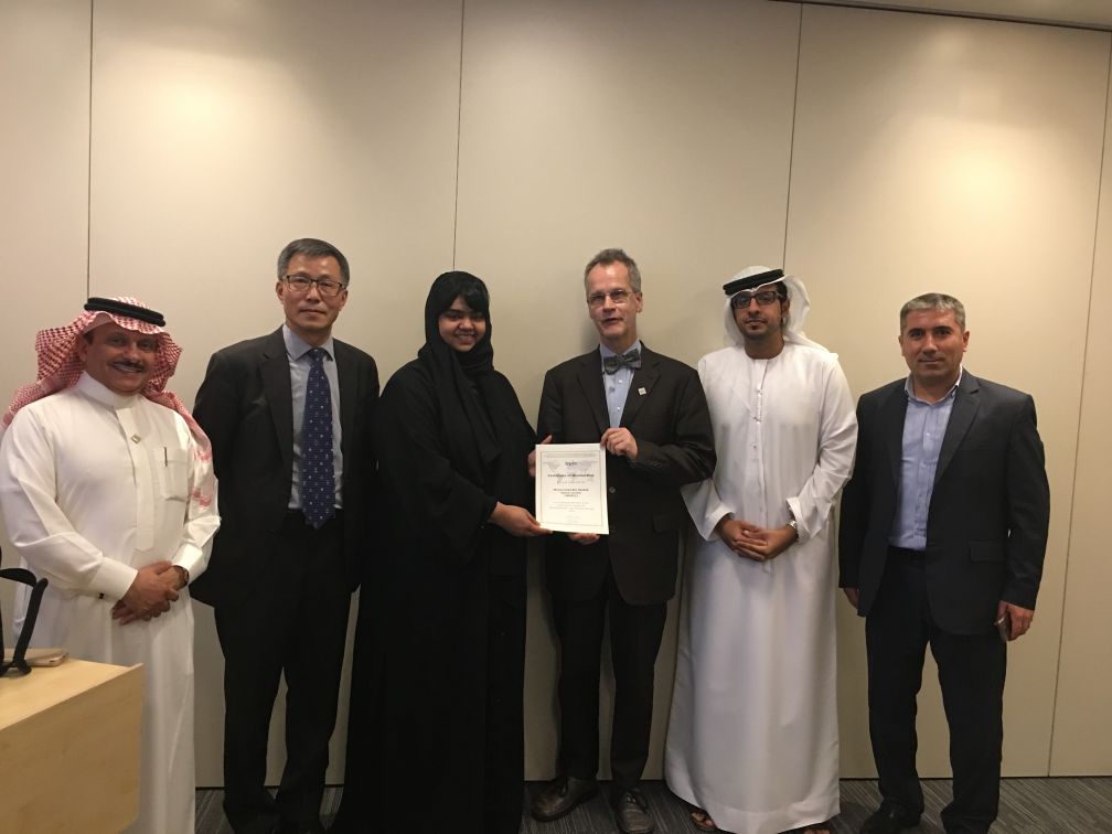
ISPRS representative at MBRSC:
from the left: Muhamad Alrajhi (ISPRS Reg. Coord. Arab States), Songnian Li, (ISPRS Treasurer), Ghariba Salem (MBRSC), Christian Heipke (ISPRS President), Saed Al Mansoori (MBRSC), Abdalla Alobeid (ISPRS Vice-Reg. Coord. Arab States)
PhotoGAUGE, Inc. is a California-based startup that offers photogrammetry-based measurement and inspection services to manufacturers. The proprietary workflow takes a series of photographs obtained using commodity cameras, converts them into an accurate 3D scan and compares them to manufacturer’s specifications to produce customized outputs. The accuracy and precision of their outputs are only as good as the photogrammetry pipeline is, and therefore a fundamental understanding of the underpinning concepts is paramount to the success.
The founders of PhotoGAUGE come from a Computer Vision background.
They were recently introduced to the activities of ISPRS by a contact at the Indian Institute of Remote Sensing.
Read more on PhotoGAUGE here…
Council heartily welcomes the new members to ISPRS and looks forward to a strong collaboration with each of them in the future.
|
|

|
|
ISPRS Scientific Initiatives: Announcement of 2019 Funding
By Songnian Li, ISPRS Treasurer
In accordance with the statutory mission and activities of ISPRS, the Society shall provide funds to support scientific and other initiatives, which will further improve its international status in the field of the photogrammetry, remote sensing and spatial information sciences, and will therefore benefit all ISPRS members. The Scientific Initiatives is a program ISPRS has carried out for one of its focuses on science and development. After two rounds of calls for Scientific Initiatives projects for 2014, 2015 and 2017 physical years, the Council issued a new call in June 2018 for 2019 projects, with an original total budget of 60,000 Swiss Francs.
Read more here…
↑ Up
|
|
|
| |
|
General Announcements
 |
|
GEO and Amazon Web Services collaborate to provide Cloud Credits for Projects that improve Understanding of our Planet
A new collaboration between GEO and Amazon Web Services (AWS) offers GEO Member agencies and research organizations from developing countries access to cloud services to help with the hosting, processing and analysis of big data about the Earth to inform decisions for sustainable development.
Eligible government agencies and research institutions can apply for AWS credits that will enable them to build Earth observations applications that support environmental and development goals, including the Sendai Framework for Disaster Risk Reduction, the Paris Agreement and the United Nations Sustainable Development Goals.
Recipients of cloud credits through this initiative will also receive support from the GEO community and AWS experts to refine and implement their projects for the best possible results. AWS and GEO first announced their collaboration in 2017 to support the Global Earth Observation System of Systems (GEOSS) open data platform.
Visit website
Read full press release
↑ Up
|
|
|
| |
|
Announcements of Scientific Meetings
(see also
ISPRS Calendar)
|
|
|
The 2019 ISPRS Workshop on Cryosphere and Hydrosphere for Global Change Studies (CHGCS 2019)
June 14, 2019
Enschede, The Netherlands
In conjunction with the ISPRS Geospatial Week 2019, June 10-14, 2019.
Full paper submission deadline (for Annals) Jan. 17, 2019
Abstract submission deadline (for Archives, min. 4 pages) Feb. 4, 2019
See the First Circulation flyer here…
For more information, please visit https://www.gsw2019.org/chgcs/ |
 |
|
27th International CIPA Symposium
September 1-5, 2019
Avila, Spain

CIPA - Heritage Documentation - is an international non-profit organization that applies technologies for the benefit of recording, conserving and documenting cultural heritage in all its possible forms. CIPA keeps up with technologies and ensures their usefulness for cultural heritage conservation, education and dissemination. CIPA, co-founded by ISPRS and ICOMOS in 1968, organises every odd year an international symposium.
The symposium will provide a platform for the exchange of ideas, best practices as well as scientific research papers in the field of cultural heritage. Papers in all areas of 3D recording, modelling, conservation, documentation, valorization and preservation of Cultural Heritage are invited. Some tutorials, focusing on underwater photogrammetry, structural analyses, inventory and management of heritage, HBIM and virtual / augmented / mixed reality for heritage, will open the Symposium. Full Papers for the ISPRS Annals are due to Feb 22nd, 2019 whereas Abstracts for the ISPRS Archives are due to March 4th, 2019.
More info can be found at http://www.cipa2019.org/ |
 |
|
Gi4DM 2019
September 3-6, 2019
Prague National Library of Technology, Czech Republic
We are pleased to invite you to submit an abstract and, in case of acceptance, your paper to this conference. All accepted papers will be published in ISPRS Archives. The ISPRS Archives are listed in the ISI Conference Proceedings Citation Index (CPCI) of the Web of Science, SCOPUS, and the Directory of Open Access Journals (DOAJ).
Abstract Submission Deadline: May 1, 2019
Full Paper Submission Deadline: July 20, 2019
Paper submission is already open
See the flyer here…
More information can be found at: www.gi4dm2019.org
↑ Up
|
|
|
| |
|
Event Reports
 |
|
2018 3D GeoInfo Conference
October 1-5, 2018
Delft, Netherlands
Read the report
here…
|
 |
|
Smart Data and Smart Cities in Delft
October 1-5, 2018
Delft, Netherlands
Read the report
here… |
 |
|
2nd ISPRS Workshop on Remote Sensing and Synergic Analysis on Atmospheric Environment
Nov. 6-9, 2018
Guangzhou, China
Read the report
here… |
 |
|
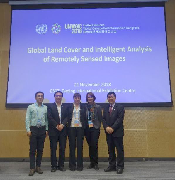
“Global Land Cover and Intelligent Analysis of Remotely Sensed Image” Session at UNWGIS
November 19 - 21, 2018
Deqing, Zhejiang Province, China
Read the report
here…
↑ Up
|
|
|
| |
|
ISPRS International Journal of Geo-Information — Open Access Journal
 |
|
New publications in the ISPRS International Journal of Geo-Information
Open Access Journal
Volume 7, Issue 10 (October 2018)
Incremental Road Network Generation Based on Vehicle Trajectories
Ni, Zhongyi, Xie, Lijun, Xie, Tian, Shi, Binhua, Zheng, Yao
No: 382
Care, Indifference and Anxiety—Attitudes toward Location Data in Everyday Life
Rzeszewski, Michal, Luczys, Piotr
No: 383
Design and Development of a 3D Digital Cadastre Visualization Prototype
Shojaei, Davood, Olfat, Hamed, Rajabifard, Abbas, Briffa, Mark
No: 384
Geospatial IoT—The Need for Event-Driven Architectures in Contemporary Spatial Data Infrastructures
Rieke, Matthes, Bigagli, Lorenzo, Herle, Stefan, Jirka, Simon, Kotsev, Alexander, Liebig, Thomas, Malewski, Christian, Paschke, Thomas, Stasch, Christoph
No: 385
Profiling the Spatial Structure of London: From Individual Tweets to Aggregated Functional Zones
Zhong, Chen, Zeng, Shi, Tu, Wei, Yoshida, Mitsuo
No: 386
Urban Growth Modeling and Future Scenario Projection Using Cellular Automata (CA) Models and the R Package Optimx
Feng, Yongjiu, Cai, Zongbo, Tong, Xiaohua, Wang, Jiafeng, Gao, Chen, Chen, Shurui, Lei, Zhenkun
No: 387
Identifying Urban Neighborhood Names through User-Contributed Online Property Listings
McKenzie, Grant, Liu, Zheng, Hu, Yingjie, Lee, Myeong
No: 388
Multi-Temporal Sentinel-1 and -2 Data Fusion for Optical Image Simulation
He, Wei, Yokoya, Naoto
No: 389
The Effects of Land Use and Land Cover Geoinformation Raster Generalization in the Analysis of LUCC in Portugal
Meneses, Bruno M., Reis, Eusébio, Reis, Rui, Vale, Maria J.
No: 390
Duality and Dimensionality Reduction Discrete Line Generation Algorithm for a Triangular Grid
Du, Lingyu, Ma, Qiuhe, Ben, Jin, Wang, Rui, Li, Jiahao
No: 391
Automated Identification of Discrepancies between Nautical Charts and Survey Soundings
Masetti, Giuseppe, Faulkes, Tyanne, Kastrisios, Christos
No: 392
From IFC to 3D Tiles: An Integrated Open-Source Solution for Visualising BIMs on Cesium
Chen, Yiqun, Shooraj, Erfan, Rajabifard, Abbas, Sabri, Soheil
No: 393
Regional Landslide Identification Based on Susceptibility Analysis and Change Detection
Si, Alu, Zhang, Jiquan, Tong, Siqin, Lai, Quan, Wang, Rui, Li, Na, Bao, Yongbin
No: 394
Bathymetric Photogrammetry to Update CHS Charts: Comparing Conventional 3D Manual and Automatic Approaches
Chénier, René, Faucher, Marc-André, Ahola, Ryan, Shelat, Yask, Sagram, Mesha
No: 395
Mapping Frictions Inhibiting Bicycle Commuting
Pajarito, Diego, Gould, Michael
No: 396
CO-RIP: A Riparian Vegetation and Corridor Extent Dataset for Colorado River Basin Streams and Rivers
Woodward, Brian D., Evangelista, Paul H., Young, Nicholas E., Vorster, Anthony G., West, Amanda M., Carroll, Sarah L., Girma, Rebecca K., Hatcher, Emma Zink, Anderson, Ryan, Vahsen, Megan L., Vashisht, Amandeep, Mayer, Timothy, Carver, Daniel, Jarnevich, Catherine
No: 397
Using Satellite-Borne Remote Sensing Data in Generating Local Warming Maps with Enhanced Resolution
Rahaman, Khan Rubayet, Ahmed, M. Razu, Hassan, Quazi K.
No: 398
High-Performance Geospatial Big Data Processing System Based on MapReduce
Jo, Junghee, Lee, Kang-Woo
No: 399
Analyzing OpenStreetMap Road Data and Characterizing the Behavior of Contributors in Ankara, Turkey
Hacar, Müslüm, Kılıç, Batuhan, Şahbaz, Kadir
No: 400
Fusion of SAR and Multispectral Images Using Random Forest Regression for Change Detection
Seo, Dae Kyo, Kim, Yong Hyun, Eo, Yang Dam, Lee, Mi Hee, Park, Wan Yong
No: 401
Improved Jitter Elimination and Topology Correction Method for the Split Line of Narrow and Long Patches
Li, Chengming, Yin, Yong, Wu, Pengda, Liu, Xiaoli, Guo, Peipei
No: 402
Modeling Patterns of Land Use in Chinese Cities Using an Integrated Cellular Automata Model
Feng, Yanlei, Qi, Yi
No: 403
Multi-Agent Planning for Automatic Geospatial Web Service Composition in Geoportals
Farnaghi, Mahdi, Mansourian, Ali
No: 404
Sentinel-2 Based Temporal Detection of Agricultural Land Use Anomalies in Support of Common Agricultural Policy Monitoring
Kanjir, Urška, Đurić, Nataša, Veljanovski, Tatjana
No: 405
Change Detection for Building Footprints with Different Levels of Detail Using Combined Shape and Pattern Analysis
Zhou, Xiaodong, Chen, Zhe, Zhang, Xiang, Ai, Tinghua
No: 406
Mapping the Changes in Urban Greenness Based on Localized Spatial Association Analysis under Temporal Context Using MODIS Data
Sha, Zongyao, Ali, Yahya, Wang, Yuwei, Chen, Jiangping, Tan, Xicheng, Li, Ruren
No: 407
Comparison of Landscape Metrics for Three Different Level Land Cover/Land Use Maps
Sertel, Elif, Topaloğlu, Raziye Hale, Şallı, Betül, Yay Algan, Irmak, Aksu, Gül Aslı
No: 408
An Improved Progressive TIN Densification Filtering Method Considering the Density and Standard Variance of Point Clouds
Dong, Youqiang, Cui, Ximin, Zhang, Li, Ai, Haibin
No: 409
Line-Constrained Shape Feature for Building Change Detection in VHR Remote Sensing Imagery
Liu, Haifei, Yang, Minhua, Chen, Jie, Hou, Jialiang, Deng, Min
No: 410
Monthly Analysis of Wetlands Dynamics Using Remote Sensing Data
Kaplan, Gordana, Avdan, Ugur
No: 411
A Novel 3D Anisotropic Total Variation Regularized Low Rank Method for Hyperspectral Image Mixed Denoising
Sun, Le, Zhan, Tianming, Wu, Zebin, Jeon, Byeungwoo
No: 412
Three-Dimensional Rule-Based City Modelling to Support Urban Redevelopment Process
Agius, Tyler, Sabri, Soheil, Kalantari, Mohsen
No: 413
↑ Up
New publications in the ISPRS International Journal of Geo-Information
Open Access Journal
Volume 7, Issue 11 (November 2018)
From Global Goals to Local Gains—A Framework for Crop Water Productivity
Blatchford, Megan Leigh, Karimi, Poolad, Bastiaanssen, W.G.M., Nouri, Hamideh
No: 414
Evaluation of User Performance in Interactive and Static 3D Maps
Herman, Lukáš, Juřík, Vojtěch, Stachoň, Zdeněk, Vrbík, Daniel, Russnák, Jan, Řezník, Tomáš
No: 415
Measurement of Opportunity Cost of Travel Time for Predicting Future Residential Mobility Based on the Smart Card Data of Public Transportation
Maeda, Takashi Nicholas, Mori, Junichiro, Ochi, Masanao, Sakimoto, Tetsuo, Sakata, Ichiro
No: 416
A High-Definition Road-Network Model for Self-Driving Vehicles
Zheng, Ling, Li, Bijun, Zhang, Hongjuan, Shan, Yunxiao, Zhou, Jian
No: 417
Method for Mapping Rice Fields in Complex Landscape Areas Based on Pre-Trained Convolutional Neural Network from HJ-1 A/B Data
Jiang, Tian, Liu, Xiangnan, Wu, Ling
No: 418
A Full Level-of-Detail Specification for 3D Building Models Combining Indoor and Outdoor Scenes
Tang, Lei, Li, Lin, Ying, Shen, Lei, Yuan
No: 419
Neural-Network Time-Series Analysis of MODIS EVI for Post-Fire Vegetation Regrowth
Vasilakos, Christos, Tsekouras, George E., Palaiologou, Palaiologos, Kalabokidis, Kostas
No: 420
Measuring Urban Land Cover Influence on Air Temperature through Multiple Geo-Data—The Case of Milan, Italy
Oxoli, Daniele, Ronchetti, Giulia, Minghini, Marco, Molinari, Monia Elisa, Lotfian, Maryam, Sona, Giovanna, Brovelli, Maria Antonia
No: 421
Design of a Generic Mobile GIS for Professional Users
Kuper, Paul Vincent
No: 422
A Task-Oriented Knowledge Base for Geospatial Problem-Solving
Zhuang, Can, Xie, Zhong, Ma, Kai, Guo, Mingqiang, Wu, Liang
No: 423
Assessment of Segmentation Parameters for Object-Based Land Cover Classification Using Color-Infrared Imagery
Akcay, Ozgun, Avsar, Emin Ozgur, Inalpulat, Melis, Genc, Levent, Cam, Ahmet
No: 424
Street Centralities and Land Use Intensities Based on Points of Interest (POI) in Shenzhen, China
Wang, Shuai, Xu, Gang, Guo, Qingsheng
No: 425
Application of Open-Source Software in Community Heritage Resources Management
Jan, Jihn-Fa
No: 426
Effect of Size, Shape and Map Background in Cartographic Visualization: Experimental Study on Czech and Chinese Populations
Stachoň, Zdeněk, Šašinka, Čeněk, Čeněk, Jiří, Angsüsser, Stephan, Kubíček, Petr, Štěrba, Zbyněk, Bilíková, Martina
No: 427
The Scope of Earth-Observation to Improve the Consistency of the SDG Slum Indicator
Kuffer, Monika, Wang, Jiong, Nagenborg, Michael, Pfeffer, Karin, Kohli, Divyani, Sliuzas, Richard, Persello, Claudio
No: 428
Importance of Remotely-Sensed Vegetation Variables for Predicting the Spatial Distribution of African Citrus Triozid (Trioza erytreae) in Kenya
Richard, Kyalo, Abdel-Rahman, Elfatih M., Mohamed, Samira A., Ekesi, Sunday, Borgemeister, Christian, Landmann, Tobias
No: 429
Use of a Multilayer Perceptron to Automate Terrain Assessment for the Needs of the Armed Forces
Pokonieczny, Krzysztof
No: 430
Intact Planar Abstraction of Buildings via Global Normal Refinement from Noisy Oblique Photogrammetric Point Clouds
Zhu, Qing, Wang, Feng, Hu, Han, Ding, Yulin, Xie, Jiali, Wang, Weixi, Zhong, Ruofei
No: 431
Winter Is Coming: A Socio-Environmental Monitoring and Spatiotemporal Modelling Approach for Better Understanding a Respiratory Disease
Marek, Lukas, Campbell, Malcolm, Epton, Michael, Kingham, Simon, Storer, Malina
No: 432
Impaired Water Hazard Zones: Mapping Intersecting Environmental Health Vulnerabilities and Polluter Disproportionality
Liévanos, Raoul S.
No: 433
An Automatic Recognition and Positioning Method for Point Source Targets on Satellite Images
Li, Kai, Zhang, Yongsheng, Zhang, Zhenchao, Yu, Ying
No: 434
Spatial Distribution Estimates of the Urban Population Using DSM and DEM Data in China
Zhang, Junlin, Xu, Wei, Qin, Lianjie, Tian, Yugang
No: 435
Crisis Maps—Observed Shortcomings and Recommendations for Improvement
Kuveždić Divjak, Ana, Lapaine, Miljenko
No: 436
The Elephant in the Room: Informality in Tanzania’s Rural Waterscape
Katomero, Jesper, Georgiadou, Yola
No: 437
Landslide Susceptibility Mapping Using Logistic Regression Analysis along the Jinsha River and Its Tributaries Close to Derong and Deqin County, Southwestern China
Sun, Xiaohui, Chen, Jianping, Bao, Yiding, Han, Xudong, Zhan, Jiewei, Peng, Wei
No: 438
Automatic Parametrization of Urban Areas Using ALS Data: The Case Study of Santiago de Compostela
Soilán, Mario, Riveiro, Belén, Liñares, Patricia, Pérez-Rivas, Andrea
No: 439
Low-Power LoRa Signal-Based Outdoor Positioning Using Fingerprint Algorithm
Choi, Wongeun, Chang, Yoon-Seop, Jung, Yeonuk, Song, Junkeun
No: 440
Change Detection in Coral Reef Environment Using High-Resolution Images: Comparison of Object-Based and Pixel-Based Paradigms
Zhou, Zhenjin, Ma, Lei, Fu, Tengyu, Zhang, Ge, Yao, Mengru, Li, Manchun
No: 441
Complying with Privacy Legislation: From Legal Text to Implementation of Privacy-Aware Location-Based Services
Ataei, Mehrnaz, Degbelo, Auriol, Kray, Christian, Santos, Vitor
No: 442
Effective Identification of Terrain Positions from Gridded DEM Data Using Multimodal Classification Integration
Jiang, Ling, Ling, Dequan, Zhao, Mingwei, Wang, Chun, Liang, Qiuhua, Liu, Kai
No: 443
Multi-Criteria Decision Making (MCDM) Model for Seismic Vulnerability Assessment (SVA) of Urban Residential Buildings
Alizadeh, Mohsen, Hashim, Mazlan, Alizadeh, Esmaeil, Shahabi, Himan, Karami, Mohammad Reza, Beiranvand Pour, Amin, Pradhan, Biswajeet, Zabihi, Hassan
No: 444
Species-Level Vegetation Mapping in a Himalayan Treeline Ecotone Using Unmanned Aerial System (UAS) Imagery
Mishra, Niti B., Mainali, Kumar P., Shrestha, Bharat B., Radenz, Jackson, Karki, Debendra
No: 445
Building a Framework of Usability Patterns for Web Applications in Spatial Data Infrastructures
Henzen, Christin
No: 446
Modelling, Validation and Quantification of Climate and Other Sensitivities of Building Energy Model on 3D City Models
Murshed, Syed Monjur, Picard, Solène, Koch, Andreas
No: 447
Toward Model-Generated Household Listing in Low- and Middle-Income Countries Using Deep Learning
Chew, Robert, Jones, Kasey, Unangst, Jennifer, Cajka, James, Allpress, Justine, Amer, Safaa, Krotki, Karol
No: 448
Estimation of Hourly Link Population and Flow Directions from Mobile CDR
Lwin, Ko Ko, Sekimoto, Yoshihide, Takeuchi, Wataru
No: 449
Real-Time Efficient Exploration in Unknown Dynamic Environments Using MAVs
Mohamed, Haytham, Moussa, Adel, Elhabiby, Mohamed, El-Sheimy, Naser
No: 450
Direct Impacts of Climate Change and Indirect Impacts of Non-Climate Change on Land Surface Phenology Variation across Northern China
Luo, Zhaohui, Song, Qingmei, Wang, Tao, Zeng, Huanmu, He, Tao, Zhang, Hengjun, Wu, Wenchen
No: 451
Place versus Space: From Points, Lines and Polygons in GIS to Place-Based Representations Reflecting Language and Culture
Blaschke, Thomas, Merschdorf, Helena, Cabrera-Barona, Pablo, Gao, Song, Papadakis, Emmanuel, Kovacs-Györi, Anna
No: 452
↑ Up
|
|
|
| |
|
ISPRS Journal of Photogrammetry and Remote Sensing
 |
|
New publications in the ISPRS Journal of
Photogrammetry and Remote Sensing Volume 146 (December 2018)
Editorial Board
Pages: ii
The impact of dataset selection on land degradation assessment
Arden L. Burrell, Jason P. Evans, Yi Liu
Pages: 22-37
Analyzing the role of pulse density and voxelization parameters on full-waveform LiDAR-derived metrics
Pablo Crespo-Peremarch, Luis Ángel Ruiz, Ángel Balaguer-Beser, Javier Estornell
Pages: 453-464
A phenology-based approach to the classification of Arctic tundra ecosystems in Greenland
Mojtaba Karami, Andreas Westergaard-Nielsen, Signe Normand, Urs A. Treier, Bo Elberling, Birger U. Hansen
Pages: 518-529
Progressively Expanded Neural Network (PEN Net) for hyperspectral image classification: A new neural network paradigm for remote sensing image analysis
Paheding Sidike, Vijayan K. Asari, Vasit Sagan
Pages: 161-181
Successional stages and their evolution in tropical forests using multi-temporal photogrammetric surface models and superpixels
Adilson Berveglieri, Nilton N. Imai, Antonio M.G. Tommaselli, Baltazar Casagrande, Eija Honkavaara
Pages: 548-558
Applications and impacts of Google Earth: A decadal review (2006–2016)
Jianming Liang, Jianhua Gong, Wenhang Li
Pages: 91-107
Road safety evaluation through automatic extraction of road horizontal alignments from Mobile LiDAR System and inductive reasoning based on a decision tree
José Antonio Martín-Jiménez, Santiago Zazo, José Juan Arranz Justel, Pablo Rodríguez-Gonzálvez, Diego González-Aguilera
Pages: 334-346
Determining spectral groups to distinguish oil emulsions from Sargassum over the Gulf of Mexico using an airborne imaging spectrometer
Jing Shi, Junnan Jiao, Yingcheng Lu, Minwei Zhang, Zhihua Mao, Yongxue Liu
Pages: 251-259
Determination of changes in leaf and canopy spectra of plants grown in soils contaminated with petroleum hydrocarbons
S. Gürtler, C.R. Souza Filho, I.D. Sanches, M.N. Alves, W.J. Oliveira
Pages: 272-288
An automatic approach for land-change detection and land updates based on integrated NDVI timing analysis and the CVAPS method with GEE support
Yunfeng Hu, Yu Dong, Batunacun
Pages: 347-359
Drainage ditch extraction from airborne LiDAR point clouds
Jennifer Roelens, Bernhard Höfle, Stefaan Dondeyne, Jos Van Orshoven, Jan Diels
Pages: 409-420
Color calibration of digital images for agriculture and other applications
S. Sunoj, C. Igathinathane, N. Saliendra, J. Hendrickson, D. Archer
Pages: 221-234
DEM refinement by low vegetation removal based on the combination of full waveform data and progressive TIN densification
Hongchao Ma, Weiwei Zhou, Liang Zhang
Pages: 260-271
A new generation of the United States National Land Cover Database: Requirements, research priorities, design, and implementation strategies
Limin Yang, Suming Jin, Patrick Danielson, Collin Homer, Leila Gass, Stacie M. Bender, Adam Case, Catherine Costello, Jon Dewitz, Joyce Fry, Michelle Funk, Brian Granneman, Greg C. Liknes, Matthew Rigge, George Xian
Pages: 108-123
Structure from Motion for aerial thermal imagery at city scale: Pre-processing, camera calibration, accuracy assessment
Paolo Conte, Valentina A. Girelli, Emanuele Mandanici
Pages: 320-333
Hyperspectral anomalous change detection based on joint sparse representation
Chen Wu, Bo Du, Liangpei Zhang
Pages: 137-150
HSW: Heuristic Shrink-wrapping for automatically repairing solid-based CityGML LOD2 building models
Junqiao Zhao, Hugo Ledoux, Jantien Stoter, Tiantian Feng
Pages: 289-304
Joining multi-epoch archival aerial images in a single SfM block allows 3-D change detection with almost exclusively image information
D. Feurer, F. Vinatier
Pages: 495-506
An improved progressive morphological filter for UAV-based photogrammetric point clouds in river bank monitoring
Yumin Tan, Shuai Wang, Bo Xu, Jiabin Zhang
Pages: 421-429
Evaluation of the AVHRR DeepBlue aerosol optical depth dataset over mainland China
Yahui Che, Yong Xue, Jie Guang, Lu She, Jianping Guo
Pages: 74-90
Detection of individual trees in urban alignment from airborne data and contextual information: A marked point process approach
Josselin Aval, Jean Demuynck, Emmanuel Zenou, Sophie Fabre, David Sheeren, Mathieu Fauvel, Karine Adeline, Xavier Briottet
Pages: 197-210
Tweets or nighttime lights: Comparison for preeminence in estimating socioeconomic factors
Naizhuo Zhao, Guofeng Cao, Wei Zhang, Eric L. Samson
Pages: 1-10
Towards operational marker-free registration of terrestrial lidar data in forests
Jean-François Tremblay, Martin Béland
Pages: 430-435
Mapping underrepresented land cover heterogeneity in arid regions: The Sahara-Sahel example
João Carlos Campos, José Carlos Brito
Pages: 211-220
Variability in annual temperature cycle in the urban areas of the United States as revealed by MODIS imagery
Peng Fu, Qihao Weng
Pages: 65-73
High-density stereo image matching using intrinsic curves
Mozhdeh Shahbazi, Gunho Sohn, Jérome Théau
Pages: 373-388
UAV-based multispectral remote sensing for precision agriculture: A comparison between different cameras
Lei Deng, Zhihui Mao, Xiaojuan Li, Zhuowei Hu, Fuzhou Duan, Yanan Yan
Pages: 124-136
Exploring the potential of Rayleigh-corrected reflectance in coastal and inland water applications: A simple aerosol correction method and its merits
Lian Feng, Xuejiao Hou, Junsheng Li, Yi Zheng
Pages: 52-64
Estimating forest structural attributes using UAV-LiDAR data in Ginkgo plantations
Kun Liu, Xin Shen, Lin Cao, Guibin Wang, Fuliang Cao
Pages: 465-482
An automated mathematical morphology driven algorithm for water body extraction from remotely sensed images
C.A. Rishikeshan, H. Ramesh
Pages: 11-21
Social functional mapping of urban green space using remote sensing and social sensing data
Wei Chen, Huiping Huang, Jinwei Dong, Yuan Zhang, Yichen Tian, Zhiqi Yang
Pages: 436-452
A multi-UAV cooperative route planning methodology for 3D fine-resolution building model reconstruction
Xiaocui Zheng, Fei Wang, Zhanghua Li
Pages: 483-494
Super-resolution of Sentinel-2 images: Learning a globally applicable deep neural network
Charis Lanaras, José Bioucas-Dias, Silvano Galliani, Emmanuel Baltsavias, Konrad Schindler
Pages: 305-319
Retraction notice to “Use of LiDAR for Calculating Solar Irradiance on Roofs and Façades of Buildings at City Scale: Methodology, Validation, and Analysis” [ISPRS Journal of Photogrammetry and Remote Sensing – 138 (2018)12-29]
Liang Cheng, Hao Xu, Shuyi Li, Yanming Chen, Fangli Zhang, Manchun L
Pages: 530
Multiple instance hybrid estimator for hyperspectral target characterization and sub-pixel target detection
Changzhe Jiao, Chao Chen, Ronald G. McGarvey, Stephanie Bohlman, Licheng Jiao, Alina Zare
Pages: 235-250
Accuracy assessment of NLCD 2011 impervious cover data for the Chesapeake Bay region, USA
J. Wickham, N. Herold, S.V. Stehman, C.G. Homer, G. Xian, P. Claggett
Pages: 151-160
Deep networks under scene-level supervision for multi-class geospatial object detection from remote sensing images
Yansheng Li, Yongjun Zhang, Xin Huang, Alan L. Yuille
Pages: 182-196
A framework for SAR-optical stereogrammetry over urban areas
Hossein Bagheri, Michael Schmitt, Pablo d’Angelo, Xiao Xiang Zhu
Pages: 389-408
Iterative feature mapping network for detecting multiple changes in multi-source remote sensing images
Tao Zhan, Maoguo Gong, Jia Liu, Puzhao Zhang
Pages: 38-51
Sparsity inspired pan-sharpening technique using multi-scale learned dictionary
Rajesh Gogineni, Ashvini Chaturvedi
Pages: 360-372
Remote sensing of albedo-reducing snow algae and impurities in the Maritime Antarctica
Pirjo Huovinen, Jaime Ramírez, Iván Gómez
Pages: 507-517
Soybean crop coverage estimation from NDVI images with different spatial resolution to evaluate yield variability in a plot
A. de la Casa, G. Ovando, L. Bressanini, J. Martínez, G. Díaz, C. Miranda
Pages: 531-547
New publications in the ISPRS Journal of
Photogrammetry and Remote Sensing Volume 147 (January 2019)
Editorial Board
Pages: ii
Measuring stem diameters with TLS in boreal forests by complementary fitting procedure
Timo P. Pitkänen, Pasi Raumonen, Annika Kangas
Pages: 294-306
Efficient and robust lane marking extraction from mobile lidar point clouds
Jaehoon Jung, Erzhuo Che, Michael J. Olsen, Christopher Parrish
Pages: 1-18
Ailanthus altissima mapping from multi-temporal very high resolution satellite images
Cristina Tarantino, Francesca Casella, Maria Adamo, Richard Lucas, Carl Beierkuhnlein, Palma Blonda
Pages: 90-103
Spectral-consistent relative radiometric normalization for multitemporal Landsat 8 imagery
Muhammad Aldila Syariz, Bo-Yi Lin, Lino Garda Denaro, Lalu Muhamad Jaelani, Manh Van Nguyen, Chao-Hung Lin
Pages: 56-64
Correcting rural building annotations in OpenStreetMap using convolutional neural networks
John E. Vargas-Muñoz, Sylvain Lobry, Alexandre X. Falcão, Devis Tuia
Pages: 283-293
Generating a hyperspectral digital surface model using a hyperspectral 2D frame camera
Raquel A. Oliveira, Antonio M.G. Tommaselli, Eija Honkavaara
Pages: 345-360
Segmentation-aided classification of hyperspectral data using spatial dependency of spectral bands
Annalisa Appice, Donato Malerba
Pages: 215-231
Simplification of geometric objects in an indoor space
Joon-Seok Kim, Ki-Joune Li
Pages: 146-162
Structure from motion for ordered and unordered image sets based on random k-d forests and global pose estimation
Xin Wang, Franz Rottensteiner, Christian Heipke
Pages: 19-41
Modeling alpine grassland forage phosphorus based on hyperspectral remote sensing and a multi-factor machine learning algorithm in the east of Tibetan Plateau, China
Jinlong Gao, Baoping Meng, Tiangang Liang, Qisheng Feng, Jing Ge, Jianpeng Yin, Caixia Wu, Xia Cui, Mengjing Hou, Jie Liu, Hongjie Xie
Pages: 104-117
RETRACTED: A new On-orbit Geometric Self-calibration Approach for the High-resolution Multi-linear Array Optical Satellite Based on Stereoscopic Image Pairs
Mi Wang, Yufeng Cheng, Luxiao He, Yuan Tian, Yanli Wan
Pages: 361
Learnable manifold alignment (LeMA): A semi-supervised cross-modality learning framework for land cover and land use classification
Danfeng Hong, Naoto Yokoya, Nan Ge, Jocelyn Chanussot, Xiao Xiang Zhu
Pages: 193-205
Aerial imagery for roof segmentation: A large-scale dataset towards automatic mapping of buildings
Qi Chen, Lei Wang, Yifan Wu, Guangming Wu, Zhiling Guo, Steven L. Waslander
Pages: 42-55
Scale-variable region-merging for high resolution remote sensing image segmentation
Tengfei Su
Pages: 319-334
Wavelet approach applied to EVI/MODIS time series and meteorological data
Andreise Moreira, Denise Cybis Fontana, Tatiana Mora Kuplich
Pages: 335-344
Is field-measured tree height as reliable as believed – A comparison study of tree height estimates from field measurement, airborne laser scanning and terrestrial laser scanning in a boreal forest
Yunsheng Wang, Matti Lehtomäki, Xinlian Liang, Jiri Pyörälä, Antero Kukko, Anttoni Jaakkola, Jingbin Liu, Ziyi Feng, Ruizhi Chen, Juha Hyyppä
Pages: 132-145
Multispectral change detection using multivariate Kullback-Leibler distance
Shabnam Jabari, Mohammad Rezaee, Fatemeh Fathollahi, Yun Zhang
Pages: 163-177
A multi-faceted CNN architecture for automatic classification of mobile LiDAR data and an algorithm to reproduce point cloud samples for enhanced training
Bhavesh Kumar, Gaurav Pandey, Bharat Lohani, Subhas C. Misra
Pages: 80-89
Generating a series of land covers by assimilating the existing land cover maps
Guang Xu, Baozhang Chen
Pages: 206-214
Analogue-based colorization of remote sensing images using textural information
Mathieu Gravey, Luiz Gustavo Rasera, Gregoire Mariethoz
Pages: 242-254
Evaluating the capability of the Sentinel 2 data for soil organic carbon prediction in croplands
Fabio Castaldi, Andreas Hueni, Sabine Chabrillat, Kathrin Ward, Gabriele Buttafuoco, Bart Bomans, Kristin Vreys, Maximilian Brell, Bas van Wesemael
Pages: 267-282
Practical optimal registration of terrestrial LiDAR scan pairs
Zhipeng Cai, Tat-Jun Chin, Alvaro Parra Bustos, Konrad Schindler
Pages: 118-131
A deep learning framework for road marking extraction, classification and completion from mobile laser scanning point clouds
Chenglu Wen, Xiaotian Sun, Jonathan Li, Cheng Wang, Yan Guo, Ayman Habib
Pages: 178-192
Co-polarization channel imbalance phase estimation by corner-reflector-like targets
Lei Shi, Pingxiang Li, Jie Yang, Liangpei Zhang, Xiaoli Ding, Lingli Zhao
Pages: 255-266
Marker-free coregistration of UAV and backpack LiDAR point clouds in forested areas
Przemyslaw Polewski, Wei Yao, Lin Cao, Sha Gao
Pages: 307-318
Canopy penetration depth estimation with TanDEM-X and its compensation in temperate forests
Michael Schlund, Daniel Baron, Paul Magdon, Stefan Erasmi
Pages: 232-241
Saliency detection of targets in polarimetric SAR images based on globally weighted perturbation filters
Haiyi Yang, Zongjie Cao, Zongyong Cui, Yiming Pi
Pages: 65-79
↑ Up
|
|
|
| |
|
New Events
10-13 Feb 2019
International Geoinformatics Conference 2019
http://saudigs.org/en/internationalgeoinformatics-conference2019-index-2/
Riyadh, Saudi Arabia
18-21 Mar 2019
RSCy2019
Seventh International Conference On Remote Sensing and Geo-Information of the Environment
http://www.cyprusremotesensing.com/rscy2019
Paphos, Cyprus
01-04 Jul 2019
39th EARSeL Symposium DIGITAL | EARTH | OBSERVATION
http://symposium.earsel.org/39th-symposium-Salzburg/
Salzburg, Austria
15-18 Aug 2019
15th South East Asia Survey Congress
“Collaboration, Communication and Capacity Building”
http://seasc2019darwin.com.au/
Darwin, Australia
01-03 Oct 2019
Geospatial Kuala Lumpur 2019
http://www.geoinfo.utm.my/geospatial2019
Kuala Lumpur, Malaysia
12-14 Oct 2019
Joint SMPR and GIResearch 2019
Sensors and Models in Photogrammetry and Remote Sensing
http://geospatialconf2019.ut.ac.ir
Tehran, Iran
07-09 Nov 2019
ISAG2019
International Symposium on Applied Geoinformatics
http://isag-2019.yildiz.edu.tr
Istanbul, Turkey
» See more
|
|
| |
|
Updated Events
16-20 Sep 2019
Workshop and Summer School on the Evaluation and Benchmarking Sensors, Systems and Geospatial Data in Photogrammetry and Remote Sensing
http://ptfit.sgp.geodezja.org.pl/workshop2019/
Warsaw, Poland
» See more
|
|
| |
|
Job Opportunities
|
5-Nov-2018 |
Assistant, Associate or Full Professor OR Professor of Practice, Geospatial and Surveying Engineering
Michigan Tech University Surveying/Integrated Geospatial Technology programs, Houghton, MI, USA
|
|
15-Nov-2018 |
Researcher position in the Geomatics Division – Remote Sensing Department
Centre Tecnològic de Telecomunicacions de Catalunya (CTTC), in Castelldefels – Barcelona, Spain
|
|
27-Nov-2018 |
Assistant Professorship in Geomatics and Physical Geography
Department of Geography and Environmental Management, Faculty of Environment, University of Waterloo, Ontario, Canada
Deadline: 15-Jan-2019
|
|
28-Nov-2018 |
PhD position Using hyperspectral imaging of sediments to assess the responses of lakes to multiple stressors
Université Laval, Quebec, Canada
|
|
4-Dec-2018 |
Permanent Lectureship in Geomatic Engineering
Newcastle University, UK
Deadline: 14-Jan-2019
|
|
11-Dec-2018 |
Lecturer in Spatial Sciences
The Discipline of Geography and Spatial Sciences (GSS) at University of Tasmania, Hobart, Tasmania, Australia
Deadline: 11-Feb-2019
|
|
11-Dec-2018 |
Assistant Professorship in Surface Water Hydrology
Department of Geography at Simon Fraser University, Burnaby, British Columbia, Canada
Deadline: 15-Feb-2019
|
|
18-Dec-2018 |
GCRF Water Security and Sustainable Development Hub Manager
Newcastle University, UK
Deadline: 13-Jan-2019
|
|
18-Dec-2018 |
GCRF Water Security and Sustainable Development Hub Impacts and Communications Manager
Newcastle University, UK
Deadline: 13-Jan-2019
|
|
18-Dec-2018 |
GCRF Water Security and Sustainable Hub Core Research Fellow
Newcastle University, UK
Deadline: 13-Jan-2019
|
» See more
|
|
|
| |
|
|
 |
You got this email as you subscribed to the ISPRS mailing list.
Officers, members and contact persons of members get it by default.
To unsubscribe from the ISPRS mailing list,
click here.
© ISPRS, 2018.
Imprint
|
