Click on this
link
if you cannot read this email.
 |
 |
| |
 |
|
ISPRS e-Bulletin
Issue No 4 - 2012
|
 |
| |
|
| |
|
|
Editorial
 |
|
A term has ended
My Voyage in ISPRS
Orhan ALTAN
President of ISPRS 2008-2012
|
My involvement in ISP (RS) activities begun in late 70ties and first attendance to an event of the Society was the Technical Commission V symposium in Stockholm, where I have presented 2 papers on structural monitoring with Close-Range methods.
After this the Hamburg Congress was a miles tone in my career where I have had the chance to present several papers. During this congress I was appointed as the liaison between TCV and TCVII on "Engineering Applications".
Then the TCV Symposium in York/UK and TCVII Symposium in Tubingen/Germany were other events in ISPRS where I have participated actively. During these meetings I have learnt several colleagues working in different scientific organisations and I was invited to participate into the activities of IAG and FIG on "Engineering Applications" as Working Group or Task Group officer. I returned to ISPRS activities with the Congress in Vienna, where my institute received the "Dolezal Support" and members have presented several papers.
Working on "Photogrammetric Applications" the Turkish Ordinary Member has applied in 1999 the Council to organise the ISPRS in 2004 Congress in Istanbul me as "Candidate Congress Director". The bid was successful at the congress in Amsterdam and I have started to work as "Congress Director" in the council acted between 2000-04. Then followed by the council memberships as "Secretary General" and "President" of the Society since 2008.All during these years I have learnt many things and made many friendships. It was a very active years in Technologies in photogrammetry and remote sensing have changed enormously over the past 100 years. They were originally based on hardcopy images and outputs, and processing methods, prior to the development of computers, were aimed at avoiding computations because of their complexity. Today’s images are digital and the processing is likewise digital. As well, multi-spectral digital imaging from aircraft and satellites are far more readily available than in the past. Management of spatial data has become inherently part of the processing of information derived by image processing. Hence ISPRS now has two Technical Commissions dealing with spatial information acquisition, processing and management. ISPRS today is also governed by Statutes and Bylaws that ensure that the Society is well managed and is very active in attracting many high quality scientists to work on the ISPRS Council and to manage its scientific activities. Therefore ISPRS today has developed from the strong foundation introduced by the early leaders based on photogrammetry, into a leading broadly based Society dealing with all aspects of ′information from imagery′.
ISPRS is a ′Society of Societies′ with a mandate to include members from all regions around the world. The Society adheres to the Statutes and Bylaws of ISPRS which specify that the ′Society pursues its aims without any discrimination on grounds of race, religion, nationality, or political philosophy′. Through the ISPRS Technical Commissions we aim to attract people from as many countries as possible to participate in their activities. The newly appointed Regional Representatives from Africa, Latin America and Asia are a further demonstration of the Society’s commitment to include participants from parts of the world. Recent meetings with these representatives have proved to be very fruitful and have led to new collaborative initiatives for the regions. As well, the ISPRS Council has been very active in visiting as many national members, regional members and international organisations to encourage participation in ISPRS activities.
Major applications of our technologies have especially included managing and monitoring natural and man-made disasters. The ′JBGIS Best Practises Booklet on Geo-information for Risk and Disaster Management′ to be launched at the UN Office of Outer Space Affairs (UN-OOSA) on 2 July 2010 during the ISPRS Centenary Celebrations will document a number of examples. There has been excellent cooperation between ISPRS and UN-SPIDER in applying remote sensing technologies for disaster monitoring, management of relief for victims and documenting the impacts of the disasters. In addition, ISPRS is a member organisation of the Group on Earth Observation (GEO), which is making significant advances in the development of the Global Earth Observation System of Systems (GEOSS). Achievements of GEOSS are many, but they include: the GEOSS data sharing principles; and the Geo Web portal and GEOSS clearinghouse for searching data, information and services registries containing information about GEOSS components.
Looking into crystal balls is fraught with difficulties, not the least because one can be accountable for one’s predictions. However, in a general fashion, I think we can see an increase in the type and flexibility of new digital imaging and lidar systems; we are likely to see increasingly higher resolution space systems; there will be a continued introduction of automation for processing images, so that maps can be kept up-to-date more rapidly on a regular basis; there will be a greater availability and use of images and spatial information. However, we are not likely to see a major leap forward in these developments. Looking back over the past 10 years, the improvements have been gradual and I think this will continue to occur over the next 10 years.
The role of president is indeed very challenging, but I am grateful to my supervisors at Istanbul Technical University, who have permitted me to hold council positions in ISPRS, including the presidency. I am indebted to my colleagues at the Institute for Photogrammetry and Remote Sensing who undertake my duties in my absence. My wife Melike has encouraged me to take on this role, even though it means that she remains at home while I carry out many of my responsibilities even during very difficult times for her. I am very grateful to her for her ongoing support.
» Read the PDF version
|
|
| |
|
|
|
| |
|
|
New ISPRS officers for 2012 – 2016
During the XXII. ISPRS Congress held in Melbourne, Australia from Aug.25 to Sept. 1st, 2012 new officers for ISPRS were elected. The new council and techical commission presidents are:
| |
President |
Chen Jun (China) |
| |
Secretary General |
Christian Heipke (Germany) |
| |
1st Vice President |
Orhan Altan (Turkey) |
| |
2nd Vice President |
Marguerite Madden (USA) |
| |
Congress Director |
Lena Halounova (Czech Republic) |
| |
Treasurer |
Jon Mills (United Kingdom) |
| |
» See also |
The eight technical commissions are lead by:
| |
TCP Comm I |
Charles Toth (USA) |
| |
TCP Comm II |
Songnian Li (Canada) |
| |
TCP Comm III |
Konrad Schindler (Switzerland) |
| |
TCP Comm IV |
Jiang Jie (China) |
| |
TCP Comm V |
Fabio Remondino (Italy) |
| |
TCP Comm VI |
Jianya Gong (China) |
| |
TCP Comm VII |
Filiz Sunar (Turkey) |
| |
TCP Comm VIII |
Vinay K Dadhwal (India) |
| |
» See also |
 |
|
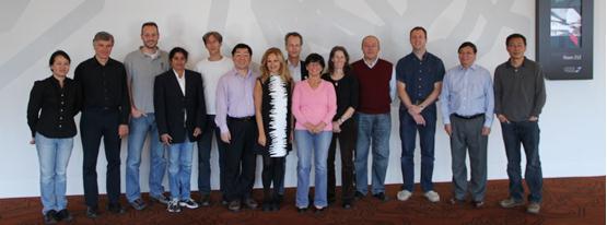
The picture shows all 14 new ISPRS officers.
|
Prof. Chen Jun, new ISPRS president, said during the closing session that while good ISPRS traditions will be kept, necessary reforms need to be implemented following the strategic plan. ISPRS is a society with a long history, high reputation and strong influence. But besides new opportunities it is currently facing grand challenges, such as strong competition and increasing demands of the society at large. The photogrammetry, remote sensing and geospatial information community has been continuously asking for more reliable, more accurate and more current information, more effective analysis and simulation, and more advanced visualization and representation. As the leading scientific society in this field, ISPRS should have a stronger scientific voice, closer collaboration with other organizations, and provide better service for society. A good team effort with open discussions, wise decisions and dedicated implementations are is required. The new ISPRS officers will do their best and mobilize all necessary resources to achieve these goals.
|
|
| |
|
|
Awards
During the Melbourne Congress a number of prestigious awards was presented to members of the scientific community. Some are mentioned in this issue of eBulletin, more will be described in the next issue:
 |
|
Franz Leberl (Austria)
received the Brock Gold Medal for his outstanding landmark contributions in the evolution
of the photogrammetry, remote sensing and spatial information sciences.
» Read more
|
 |
|
Christian Heipke (Germany)
was the recipient of the Frederick J. Doyle Award for his significant accomplishments
in advancing the photogrammetry, remote sensing and spatial information sciences and technologies.
» Read more
|
 |
|
Jan-Henrik Haunert (Germany)
received the Otto von Gruber Award for a paper of outstanding merit in the
photogrammetry, remote sensing and spatial information sciences over the 4 years prior to the Congress.
» Read more
|
 |
|
Ian Dowman (United Kingdom) and Deren Li (China)
were elected as new Honorary Members of ISPRS in recognition of their distinguished
services to the ISPRS and its aims
» Read more
|
 |
|
Dieter Fritsch (Germany), Martien Molenaar (Netherlands), Shailesh Nayak (India),
Paul Newby (United Kingdom) and Heinz Rüther (South Africa)
were made ISPRS Fellows in recognition of their sustained, excellent service to the ISPRS and its aims
» Read more
|
|
|
| |
|
|
Reports of ISPRS Events
 |
|
Joint International Conference and exhibitions on Geomatics-2011 and ISPRS Conference on Data Handling and Modeling of GeoSpatialInformation for Management of Resources
May 15-16, 2011
Teheran, Iran
The Joint International Conference and exhibitions on Geomatics-2011 and ISPRS Conference on Data Handling and Modeling of GeoSpatial Information for Management of Resources was organized on 15-16 May 2011 at the National Cartographic Centre of Iran, Tehran. The event was jointly organized by, National Cartographic Centre of Iran, ISPRS WG II/7 - Spatial Decision Support Systems and Location Based Services, ISPRS WG II/4 - Uncertainty Modelling and Quality Control for Spatial Data, Iranian Space Agency; KNTU University of Technology, and Tehran University.
» Read more
|
 |
|
10th International Symposium and Exhibition on Geoinformation 2011 (ISG 2011)
September 27-29, 2011
Selangor, Malaysia
The 10th ISG 2011 was organized by Universiti Technology Mara (UiTM), and International Society for Photogrammetry and Remote Sensing (ISPRS) on 27 - 29 September 2011 at Shah Alam Convention Centre, Selangor.
» Read more
|
 |
|
The 7th ISPRS WG VI/5 and Student Consortium Summer School Spatial Information Sciences for Environmental Monitoring
October 8-12, 2011
Jhongli, Taiwan
ISPRS WG VI/5 and the Student Consortium (SC) hold the 7th Summer School at the National Central University (NCU), Jhongli, Taoyuan, Taiwan during Oct. 8-12, 2011. The primary objective of this summer school was to improve technical knowledge and expand social networks. At NCU the host was the Center for Space and Remote Sensing Research (Director Prof. Liang-Chien Chen), while a large part of the organizational work for the School was handled by Prof. Fuan Tsai with significant contributions from Prof. Emmanuel Baltsavias, the chairman of WG VI/5. The theme of the 7th Summer School is "Spatial Information Sciences for Environmental Monitoring".
» Read more
|
 |
|
The 1st International Summer School on Mobile Mapping Technology
June 11-15, 2012
Tainan, Taiwan
This summer school is organized by the University of Calgary, the Ohio State University and National Cheng Kung University (NCKU) and officially supported by ISPRS, IAG, CSPRS and National Science Council (NSC) of Taiwan. In addition, more than ten government agencies subsidize the activities of the event as co-organizers. The summer school took place at Zenda Suites within the vicinity of NCKU campus from June 11 to 15, 2012.
» Read more
|
|
|
| |
|
|
Announcements
 |
|
New Terminology Guide
We are pleased to announce that Photogrammetric Terminology: Second
Edition by Paul R. T. Newby, Editor Emeritus of The Photogrammetric
Record, is now available (link to
DOI:
10.1111/j.1477-9730.2012.00693.x). Adapted and expanded from the
widely-used first edition, the new compilation has been completely revised and
updated. It will continue to promote consistency of language and to serve as a
"style guide" for photogrammetric literature.
|
 |
|
GIS Ostrava 2013 - Geoinformatics for City Transformations
21-23 January 2013
Ostrava, Czech Republic
The Institute of Geoinformatics would like to invite you to participate at the 10th year of the symposium GIS Ostrava 2013 - Geoinformatics for City Transformations which will take place from 21 to 23 January 2013 in Ostrava (Czech Republic). The aim of the conference is to present and discuss new methods, issues and challenges of the geoinformatics encountered in various parts of the cities transformations and how can urban geographers and city planners exploit all achievements in geoinformatics to face the current and future needs of cities. The focus of the conference is divided into seven main topics: Data for the city; Database for the city; Spatial processing for the city; Divergence in the city; Distances in the city; Development of the city and Design of the city, generally it is 6D+S. More information about proposed conference are in the attached First circular and call for papers or visit the conference websites http://gis.vsb.cz/gisostrava. The full paper submission due is on the October 12, 2012. We are looking forward to see you in Ostrava. In case of any question do not hesitate to contact our secretariat at gisostrava@vsb.cz.
|
 |
|
2012 Pacific Islands GIS & RS User Conference
27-30 November 2012
Suva, Fiji Islands
The Conference will be held from 27th to 30th November in the Holiday Inn in Suva. Monday 26th of November is reserved for workshops.
The theme of the Conference is "Mapping Pacific Resources".
The website of the Conference: http://picgisrs.appspot.com/
» Read more
|
|
|
| |
|
|
ISPRS Journal of Photogrammetry and Remote Sensing
ISPRS Journal of Photogrammetry and Remote Sensing continues to increase in size and impact
Since 2010 the number of submissions to the ISPRS Journal of Photogrammetry and Remote Sensing is showing a strong upward trend. In negotiation with Elsevier, ISPRS decided to further expand the size of the journal. Whereas the current contract between Elsevier and ISPRS specified 600 pages in 6 issues, already 1050 pages have been published in 2011. From 2013 onward the ISPRS Journal of Photogrammetry and Remote Sensing will appear monthly with a yearly budget of 1200-1400 pages.
The increasing attractiveness of the journal for authors is explained by the increasing impact factor. This factor is the average number of times that articles published in the years X-1 and X-2 are cited in the year X. It is the most used statistic to express the quality of a journal. Whereas the impact factor of the ISPRS Journal of Photogrammetry and Remote Sensing was around 1.4 in the years 2004-2007, it increased to around 2.2 in the years 2008-2010. The recently released 2011 impact factor of 2.885 marks another significant increase that will likely attract further submissions in the years to come.
The journal has a new associate editor:
Sanna Kaasalainen from the Finnish
Geodetic Institute in Espoo near Helsinki.
 |
|
New publications in the ISPRS Journal of Photogrammetry and Remote Sensing Volume 71 (July2012)
Fast AT: A simple procedure for quasi direct orientation
M. Blázquez, I. Colomina
CityGML – Interoperable semantic 3D city models
Gerhard Gröger, Lutz Plümer
Long term land cover and seagrass mapping using Landsat and object-based image analysis from 1972 to 2010 in the coastal environment of South East Queensland, Australia
Mitchell B. Lyons, Stuart R. Phinn, Chris M. Roelfsema
Monitoring water stress and fruit quality in an orange orchard under regulated deficit irrigation using narrow-band structural and physiological remote sensing indices
S. Stagakis, V. González-Dugo, P. Cid, M.L. Guillén-Climent, P.J. Zarco-Tejada
Verification of 2D building outlines using oblique airborne images
Adam Patrick Nyaruhuma, Markus Gerke, George Vosselman, Elifuraha Gerald Mtalo
New rigorous and flexible Fourier self-calibration models for airborne camera calibration
Rongfu Tang, Dieter Fritsch, Michael Cramer
An automated approach for updating land cover maps based on integrated change detection and classification methods
Xuehong Chen, Jin Chen, Yusheng Shi, Yasushi Yamaguchi
A deterministic method to integrate triangular meshes of different resolution
Giorgio Agugiaro, Thomas H. Kolbe
New publications in the ISPRS Journal of Photogrammetry and Remote Sensing Volume 72 (August 2012)
Bi-scale analysis of multitemporal land cover fractions for wetland vegetation mapping
Ryo Michishita, Zhiben Jiang, Peng Gong, Bing Xu
Point-to-plane registration of terrestrial laser scans
Darion Grant, James Bethel, Melba Crawford
Remote sensing of forage nutrients: Combining ecological and spectral absorption feature data
Nichola M. Knox, Andrew K. Skidmore, Herbert H.T. Prins, Ignas M.A. Heitkönig, Rob Slotow, Cornelis van der Waal, William F. de Boer
Classification of 10 m-resolution SPOT data using a combined Bayesian Network Classifier-shape adaptive neighborhood method
Jingxue Yang, Yunpeng Wang
Characterizing land-use classes in remote sensing imagery by shape metrics
Limin Jiao, Yaolin Liu, Hongliang Li
Spatio-temporal MODIS EVI gap filling under cloud cover: An example in Scotland
Laura Poggio, Alessandro Gimona, Iain Brown
Impact of no GCP on elevation extraction from WorldView stereo data
Th. Toutin, C.V. Schmitt, H. Wang
Assessment of soil surface roughness statistics for microwave remote sensing applications using a simple photogrammetric acquisition system
Philip Marzahn, Dirk Rieke-Zapp, Ralf Ludwig
Temporal mixture analysis for estimating impervious surface area from multi-temporal MODIS NDVI data in Japan
Fan Yang, Bunkei Matsushita, Takehiko Fukushima, Wei Yang
Mapping impervious surfaces from superresolution enhanced CHRIS/Proba imagery using multiple endmember unmixing
Luca Demarchi, Jonathan Cheung-Wai Chan, Jianglin Ma, Frank Canters
Bundle adjustment with additional constraints applied to imagery of the Dunhuang wall paintings
Yongjun Zhang, Kun Hu, Rongyong Huang
Upward-fusion urban DTM generating method using airborne Lidar data
Ziyue Chen, Bernard Devereux, Bingbo Gao, Gabriel Amable
|
|
|
| |
|
|
New Events
22-23 Oct 2012
First Latin America Conference of Free and Open Source GIS
www.fiec.espol.edu.ec/LatinOSGIS/index.php
Guayaquil, ECUADOR
6 Nov 2012
The Fourth International Workshop on Indoor Spatial Awareness
http://stem.cs.pusan.ac.kr/isa2012
Redondo Beach, CA, USA
27-30 Nov 2012
Pacific Islands GIS&RS User Conference
"Mapping Pacific Resources"
http://picgisrs.appspot.com/
Suva, FIJI ISLANDS
3-8 Dec 2012
Council Meeting (3,4,7)
Council/TCP Joint Meeting (5,6)
Chengdu, CHINA
10-14 Dec 2012
FIG3 2012 — FIG Commission 3 Workshop 2012
Joint FIG / UNECE Workshop
http://bit.ly/FIG3_Athens2012
Athens, GREECE
21-23 Jan 2013
GIS Ostrava 2013
Geoinformatics for City Transformations
http://gis.vsb.cz/gisostrava/
Ostrava, CZECH REPUBLIC
13-15 Mar 2013
Geoinformatics 2013
http://geoinformatik2013.de/index.php/en/
Heidelberg, GERMANY
24-26 Apr 2013
Interexpo GEO-Siberia-2013
and
International Workshop on Early Warning and Crisis, Disaster and Emergency Management
website not yet ready
Novosibirsk, RUSSIAN FEDERATION
15-17 May 2013
UDMS 2013 - 29th Urban Data Management Symposium
www.udms.net
London, UK
9-11 Sep 2013
2nd Joint International Symposium on Deformation Monitoring (JISDM)
website not yet ready
Nottingham, UK
28 Aug - 3 Sep 2014
ICSU General Assembly
www.icsu.org/
Auckland, NEW ZEALAND
|
|
| |
|
|
Job Opportunities
|
06-July-2012 |
Tenure-Track Faculty Position in Climate and Society, University of Waterloo, Canada |
|
20-Aug-2012 |
PhD position: Synergistic building damage assessment with air- and spaceborne remote sensing data, University of Twente, The Netherlands. |
» See more
|
|
| |
|
|
New Publications on the ISPRS Website
 |
|
ISPRS Book Series, Volume 10
Advances in Geo-Spatial Information Science
Edited by Wenzhong Shi, Michael F. Goodchild, Brian Lees and Yee Leung (Edts), 2012
» Read more
|
 |
|
ISPRS Book Series, Volume 11
Evironmental Tracking for Public Health Surveillance
Edited by Stanley A. Morain & Amelia M. Budge (Edts), 2012
» Read more
|
» See more (ISPRS Annals)
» See more (ISPRS Archives)
» See more (Non ISPRS Proceedings)
|
|
| |
|
|
|
To unsubscribe from the email list, send this with 'Unsubscribe ISPRS' in subject line to
ISPRS webmaster.
© ISPRS, 2012.
|