Click on this
link
if you cannot read this email.
 |
 |
| |
 |
|
ISPRS e-Bulletin
Issue No 1 - 2014
|
 |
| |
|
|
|
Editorial
 |
|
Tales about Prague, the city of the 2016 ISPRS Congress
The Golden Age of Bohemia and Charles IV
by Lena Halounovà
ISPRS Congress Director
|
Nearly everybody who has come to the Czech Republic has heard about Charles Bridge – one of the most famous historical sights together with Prague Castle. You can take a snap of both of them in one photograph. However there are more famous objects with the same adjective:

Prague Castle, Malá Strana and Charles Bridge
Karlův most (Charles Bridge), Karlova univerzita (Charles University), Karlovo náměstí (Charles Square), Karlštejn – castle and village near Prague, Karlovy Vary – a well-known spa in western Bohemia.
Why Charles and who was he? Charles IV (Czech: Karel IV. (1316 – 1378) is the most famous King of Bohemia. He was the second king of Bohemia from the House of Luxembourg, and the first king of Bohemia to also become Holy Roman Emperor. His mother was Elizabeth of Bohemia (Czech: Eliška Přemyslovna), a princess of the Bohemian Přemyslid dynasty who became queen consort of Bohemia as the first wife of King John the Blind (John of Luxembourg).
Charles IV received French education and was literate and fluent in five languages: Czech, French, German, Italian and Latin. He was crowned the Holy Roman Emperor in Bonn in 1346. His father was an important commander crossing Europe and taking part in many battles. However, his passion for wars ruined the Czech Lands. Charles IV started to reconstruct the King and Emperor’s power and the country itself. It was in 1344 when he founded together with his father Chrám sv. Víta (St. Vitus Cathedral) in Prague Castle. The Cathedral was finished in 1929.
If we would like to describe the activities and merits of Charles, we must mention that he founded the University of Prague (named Charles University later), the first university north of the Alps, a new quarter of Prague – Nové Město pražské (New Town of Prague) and a large castle close to Prague as a safeguard for the Czech coronation jewels. Everything was carried out in 1348 at the age of 32. The year was sad for him as his first and beloved wife Blanche de Valois died. He was married four times. All his marriages allowed him to enlargen the Czech Lands area. The best known was the last one – Elizabeth of Pomorania thanks to her ability to break swords.
When Charles came to Bohemia after his years spent in France in 1333, Prague Castle was dilapidated and all the royal castles were mortgaged and therefore he even had to live in a city house. Thanks to his decisions, Prague became one of the largest and most beautiful cities in Europe.
However his influence crossed over the boundary of the Czech Lands. His reign can be characterized as a transformation in the nature of the Empire and is remembered as the Golden Age of Bohemia.
He organized the states of the empire into peace-keeping confederations. In these, the Imperial cities figured prominently. The Swabian Landfriede confederation of 1370 was made up almost entirely of Imperial Cities.
He is famous also by bringing the first grapevine from France. The vineyards are still in many places in my country and produce wine of a high quality.
He is still regarded as Pater Patriae (father of the country or otec vlasti), a title first coined by Adalbertus Ranconis de Ericinio at his funeral.
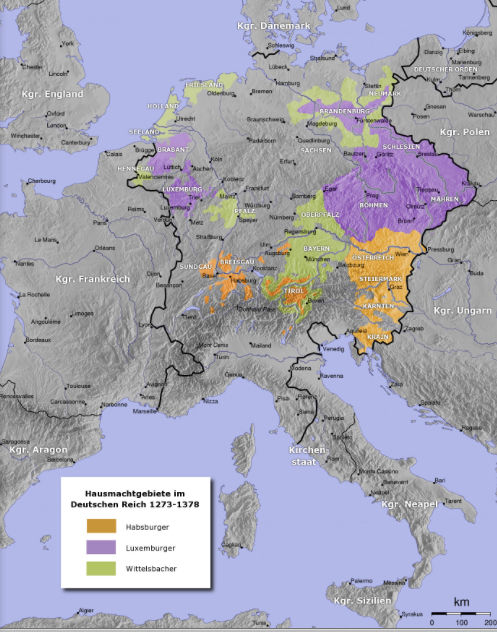
Map: Holy Roman Empire covering also the period of Charles IV (emperor in 1346 -1378)
|
|
| |
|
|
The ISPRS Foundation
|
 |
|
ISPRS and The ISPRS Foundation Join Forces for Public Outreach
by Dieter Fritsch and Christian Heipke


This issue of the ISPRS eBulletin offers for the first time joint contents of ongoing activities of ISPRS and The ISPRS Foundation (TIF). ISPRS Council and the TIF Executive Committee decided to use this medium to disseminate current information amongst the ISPRS community, to inform not only about ISPRS affairs, but also to give notice of recent developments within TIF and its plans for offering travel grants for the Midterm Symposia.
ISPRS Council is very grateful to both, TIF and its donors, for the supporting the activities in photogrammetry, remote sensing and spatial information sciences carried out by ISPRS. Without this support, in particular young scientists from less favoured nations and regions in the world would have less chance to actively participate in ISPRS. Council also believes that it is a good idea to disseminate news of the society and the foundation through the same medium, since this underlines tight connection of the two organisations.
The ISPRS Foundation (TIF) was established during the ISPRS Congress in Istanbul in 2004 and since then has been active in providing financial assistance for ISPRS affairs. In comparison with other international foundations TIF is still young. Therefore, our financial resources are limited. But so far TIF has successfully managed to increase fund raising and to provide grants to assist qualified individuals and organizations around the world. Furthermore it supports all kinds of innovation and knowledge dissemination for advancing the sciences and technologies of ISPRS. TIF offers several awards, such as awareness education, distance learning, exchange programs, fellowships, grants, internships, preservation and archiving, research initiatives, scholarships, standards projects, tools and literature and travel grants. TIF finances are governed by Bylaws according to regulations for exemption from US Federal and other taxation. The Bylaws provide for controlling the outflow of annual grant funds and therefore restrict the annual amount. For example, the annual amount spent 2012 was extraordinarily high, in total US$ 39,907 – in 2013 TIF spent in total close to US$12,000. The TIF Board of Trustees approves every finance item to be covered by TIF.
For 2014, the year of the ISPRS Midterm Symposia, TIF is ready to offer travel grants for all 8 events. Please visit the announcements below.
|
|
 |
|
Dr. Mario Hernandez new member on the TIF Board of
Trustees
The Board of Trustees of The ISPRS Foundation is pleased to announce the appointment of Dr. Mario Hernandez as its new Member. Mario is the successor of the long-term ISPRS and TIF Executive Officer Larry Fritz – his first term covers three years, until end of 2016.
» CV of Mario Hernandez
|
|
|
| |
|
|
Society News
|
 |
|
Intercommission ISPRS Conference in Antalya
a great success
Report by Uwe Sörgel
The ISPRS conference on “Serving Society with Geoinformatics” (SSG 2013, http://isprs2013-ssg.org/) was held in Antalya, Turkey, from November 11 to 17, 2013. The SSG 2013 was jointly organized by ISPRS’ Technical Commissions II, III, IV, and VII. The event included three ISPRS workshops which were scheduled to take place in the first part of the conference, namely ISA 13 - Image Sequence Analysis (11.11.13, http://www.tnt.uni-hannover.de/isprs/isa13/), CMRT 13 - City Models, Roads and Traffic (12.-13.11.13, http://www.pf.bgu.tum.de/isprs/cmrt13/), and and Laser Scanning 2013 (11.-13.11.13, http://www2.isprs.org/laser-scanning-2013/articles/ls2013.html). It was the first time, ISPRS organized such a large scientific meeting across multiple commissions in odd years.
» Read more
|
|
 |
|
ASPRS Appoints Dr. Michael Hauck as
Executive Director
ASPRS announces the appointment of Dr. Michael Hauck as the incoming ASPRS Executive Director. Outgoing Executive Director, James Plasker, announced his retirement from ASPRS, effective January 10, 2014. Hauck becomes only the fourth Executive Director in the past 47 years of the organization’s history. Both incoming and outgoing Executive Directors look forward to working together to ensure a smooth and effective transition.
Hauck has over 20 years of experience in the creation and application of remote sensing and geospatial information technologies. Reflecting the diverse membership of ASPRS, he has practiced in academic, government, Fortune 500, and start-up settings; and in industries that include transportation, energy, telecommunications, and defense. In addition to technical breadth, he is a versatile, collaborative, and adaptive leader with over a decade of general management experience that includes both board and executive positions in not-for-profit organizations. His volunteer work includes service on local, State, and National boards, e.g. the Venture West Network of entrepreneurs, the State of Wyoming Telecommunications Council, and the Transportation Research Board of the National Academies. His key scientific accomplishment has been the acquisition, processing, and interpretation of the first-ever deep seismic reflection profiles through the Himalayas, which were part of his PhD dissertation in Geological Sciences at Cornell University. Beyond training in science and engineering, Hauck is also a student of science and technology communications, and a graduate of the Wyoming trustee leadership development program.
Internet:
www.asprs.org
|
|

|
|
In Memoriam Kimberly A. Tilley (1953-2013)
ASPRS has also informed us that Kimberly A. Tilley, Associate Executive Director and Director of Communications, passed away suddenly Friday evening, December 27, 2013 at her home in Bethesda, Maryland. To ISPRS Kim was a well known, always helpful and extremely reliable point of contact. Our thoughts and those of all who knew her, are with her family and with ASPRS.
|
|
 |
|
French National Meeting on UAV
French National Meeting on UAV: "Drones et moyens légers aéroportés d'observation: recherche, développement, applications : l’état de l’art"
will take place in Montpellier, France, June 24-26, 2014.
The deadline for abstract submission was extended to March 10!
» Read more
|
|
|
| |
|
 |
|
Invitation
|
 |
|
Invitation to join WG VII/7 "Synergy in Radar and LiDAR"
Dear Colleague
The goal of the WG VII/7 Synergy in radar and lidar for 2012-2016 is to bring together researchers
from both radar and lidar remote sensing, and promote the development of joint activities and synergy
in radar and lidar research, such as joint and multi-temporal experiments on vegetation characterization
and upscaling activities. The WG will also facilitate the discussion and evaluation of models and
experimental methods by organizing workshops and providing a web page for dissemination of
resources and publications, see
website.
» Read more
|
|

|
|
|
 |
|
Quick Links
|

|
|
|
| |
|
|
General Announcements
 |
|
GEO to Keep Unleashing the Power of Open Data Mandate Unanimously Endorsed for Another 10 Years
Geneva, 17 January 2014 – In Geneva today, the Group on Earth Observations (GEO) received unanimous endorsement to unleash the power of open data for a second decade. There was agreement to continue building on the organization's first 10 years of pioneering environmental advances, which are designed to improve the quality of life of people everywhere. Fueled by open data, GEO's efforts are now evident in most regions of the world. GEO is comprised of 90 member nations, the European Commission and 77 Participating Organizations.
» Read more
|
 |
|
International Forum on Polar Data Activities in Global Data Systems
Recommendations & Observations Arising From the 'International Polar Data Forum'
15–16 October 2013, Tokyo (Japan)
Participants in the International Polar Data Forum (comprising of data managers, scientists, and research coordinators) share their observations about the current state of polar data activities and their recommendations for enhancing and sustaining core data services into the future.
» Read more
|
 |
|
UN United Nations/Belarus International Workshop on Space Technology Applications for Socio-Economic Benefits
11-15 November 2013, Minsk, Belarus
Report by by Prof. Vladimir Seredovich
The international workshop was hosted by the the Belarusian State University (BSU) on behalf of the Government of Belarus and co-sponsored by the Secure World Foundation (SWF).
The workshop programme included presentations that detailed the current use of the space technology for socio-economic benefits and discussed the on-going and planned initiative, discussion sessions the main purpose of which were a contribution to the creation and consolidation of existing networks and partnerships. A 1-day training describing the analytical and technological process from satellite observations to actionable social and/or economic decisions was offered to participants in cooperation with the International Society for Photogrammetry and Remote Sensing (ISPRS).
» Read more
|
 |
|
Call for Papers
International Journal of Geographical
Information Science
Special Issue on Big Data and Complexity Science
» Read more
|
 |
|
The ISPRS Tracking and Imaging Challenge 2014
Call for Participation
The ISPRS Tracking and Imaging Challenge 2014, TIC’14, is aiming at stimulating research and creativity between communities such as image processing, spatial computing, and GIScience. TIC’14 is requiring that two types of data are linked in innovative ways, namely trajectory data as it is captured for example from mobile positioning sensors, smart cards, or e-tags, and image data as it is captured for example from tourist photos on Flickr, smartphones, CCTV, or car mounted cameras. You may even think of wearable computing. TIC’14 is on purpose broad and open to allow for unorthodox and novel applications and methods.
For all the details please check the attached PDF document, or visit the TIC’14 website at
http://www2.isprs.org/commissions/comm2/wg8/tic.html
Looking forward to your ideas,
Your ISPRS Organizers
Stephan Winter (Melbourne), Monika Sester (Hannover) and Alper Yilmaz (Ohio State)
» Call for Participation
|
 |
|
Call for Participation –
Training Opportunity
Photogrammetric Processing of Planetary Stereo Imagery using SOCET SET®
April 29 - May 1, 2014
» Read more
|
 |
|
Call for Proposal:
Free FORMOSAT-2 Satellite Imagery
ISPRS-WG VI/5 is pleased to announce the call for proposals for free
FORMOSAT-2 satellite data. FORMOSAT-2 has a unique daily-revisiting capability to acquire images at a ground resolution of 2m
(panchromatic) and 8m (multispectral). The images are suitable for various researches and applications. Each selected proposal will be granted up to 10 archived images and/or new data acquisition requests free of charge.
Sponsored by the National Space Organization, National Applied Research Laboratories and jointly supported by the Chinese Taipei Society of Photogrammetry and Remote Sensing and the Center for Space and Remote Sensing Research, National Central University of Taiwan, This call for proposal is open to all researchers worldwide. Proposals that include ISPRS affiliated personnels (including Student Consortium
members) as PI or CI (co-investigators) will be given higher priorities.
» Call for Proposals
Visit
http://www.csrsr.ncu.edu.tw/FS2CFP
for more details and to submit proposals.
|
 |
|
Call for Papers (MSF 2014)
IEEE/ISPRS CVPR 2014 Workshop on Multi-Sensor Fusion for Dynamic Scene Understanding
Aims: This workshop will focus on multi-sensory dynamic spatial information fusion from stereo sequences, visual and infrared sequences, video and LIDAR sequences, stereo and laser sequences, Inertial Measurement Units etc. Indoor applications are also welcome to submit.
Topics of interest include, but are not limited to:
• Object detection and tracking
• Motion segmentation
• Image sequence registration
• Dynamic scene understanding
• Security/surveillance
• Vision based robot/drone navigation
• Multi-modal fusion of sensory information
• Low-level processing of different sensors
• 3D scanning sensors, laser and lidar systems
• 3D object recognition and classification
• Large scale issues
• Simultaneous localization and mapping
All manuscripts will be subject to a double-blind review process. The proceedings will be published by IEEE on the DVD proceedings of CVPR 2014, and will be available in IEEE Xplore.
The event is organized by ISPRS WG III/3 on
"Image Sequence Analysis".
Important dates
Submission site open: 18th of February 2014
Submission deadline: 12th of March 2014, 23:59 (GMT)
Notification of acceptance: 18th of April 2014
Camera-ready paper: 6th of May 2014
|
|
|
| |
|
|
Announcements of Scientific Meetings
(see also
ISPRS Calendar)
|
|
|
2014 is the year of Symposia in ISPRS.
In this issue of the eBulletin, we present the complete list incl. all available dates for abstract and paper submission.
- Technical Commission I
Denver, USA, Nov. 17-20, 2014
Theme: Sustaining Land Imaging: UAVs to Satellites
Deadline abstracts: June 6, 2014
Deadline full papers: June 6, 2014
Deadline cam.-ready manuscripts: October 17, 2014
-
Technical Commission II
Toronto, Canada, Oct. 6-8, 2014
Theme: Building Connections in GIScience for Future
Deadline abstracts: Mar 1, 2014
Deadline full papers: May 1, 2014
Deadline cam.-ready manuscripts: August 1, 2014
-
Technical Commission III
Zürich, Switzerland, Sept. 5-7, 2014
Theme: Photogrammetric Computer Vision - PCV 2014
Deadline abstracts: Feb 26, 2014
Deadline full papers: April 13, 2014
Deadline cam.-ready manuscripts: July 27, 2014
-
Technical Commission IV
Suzhou, China, May 14-16, 2014
Theme: Geospatial databases and location based services
Deadline abstracts: Jan 12, 2014 (for Archives and Annals)
Deadline full papers: Feb 17, 2014 (Archives) / Feb 28, 2014 (Annals)
Deadline cam.-ready manuscripts: March 24, 2014 (all)
Announcement
-
Technical Commission V
Riva del Garda, Italy, June 23-25, 2014
Theme: Close-range imaging, ranging and applications
Deadline abstracts: Mar 7, 2014
Deadline full papers: Mar 7, 2014
Deadline cam.-ready manuscripts: May 12, 2014
-
Technical Commission VI
Wuhan, China, May 19-21, 2014
Theme: Data, information, and knowledge sharing for geo-education
Deadline abstracts: Dec 15, 2013
Deadline cam.-ready manuscripts: Mar 16, 2014
-
Technical Commission VII
Istanbul, Turkey, Sept. 29-Oct. 2, 2014
Theme: Thematic Processing, Modeling and Analysis of Remotely Sensed Data
Deadline abstracts: Jun 1, 2014 (Archives)
Deadline full papers: May 1, 2014 (Annals)
Deadline cam.-ready manuscripts: Jul 15, 2014 (Archives)
- Technical Commission VIII
Hyderabad, India, Dec. 9-12, 2014
Theme: Tbd
Deadline abstracts: Aug 15, 2014 (tbc)
Deadline full papers: Aug 15, 2014 (tbc)
Deadline cam.-ready manuscripts: Nov 15, 2014 (tbc)
Updated information of all Symposia can be found at
www.isprs.org/society/midterm.aspx.
|
|
|
| |
|
|
Event Reports
 |
|
ISPRS Working Group IV/2 workshop on "Global Geospatial Information"
Novosibirsk, Russia
April 24–26, 2013
by Gottfried Konecny & Vladimir Komosko
» Report
|
 |
|
Joint International Workshop of ISPRS WG VIII/1 and WG IV/1 on
Geospatial Data for Disaster and Risk Reduction
Hyderabad, India
November 21-22, 2013
by Srinivasa Kumar & E. Pattabhi Rama Rao
» Report
|
 |
|
ISPRS WG IV/5 workshop on Global Spatial Grid & Cloud-based Services
Xuzhou, China
November 11–12, 2013
by Bert Veenendaal & Lixin WU
» Report
|
 |
|
ISPRS WG IV/7 joint Workshop with ACRS2013 on 3D indoor modelling and
navigation in the 34th Asian Conference on Remote Sensing 2013
Bali, Indonesia
October 20-24, 2013
by Masafumi Nakagawa
» Report
|
 |
|
ISPRS WG IV/7 joint workshop with WG I/2, ICWG II/IV, WG III/2, WG IV/6
and OGC SWG IndoorGML on 3D Indoor Modelling, Modelling, Visualisation and
Navigation
Cape Town, South Africa
December 11-13, 2013
by Sisi Zlatanova, George Sithole, Masafumi Nakagawa & Qing Zhu
» Report
|
 |
|
ISPRS ICWG IV/II/VIII Workshop on High Resolution Global Land Cover Mapping
Beijing, China
April 27-28, 2013
by Yifang Ban & Lijun Chen
» Report
|
 |
|
ISPRS/IGU/ICA Joint Workshop on Borderlands Modelling and
Understanding for Global Sustainability
Beijing, China
December 5-6, 2013
by Jun CHEN
» Report
|
 |
|
6th International Workshop on Computational Transportation Science
in conjunction with the 21th ACM SIGSPATIAL conference
Orlando, Florida, USA
November 5, 2013
by Johannes Lauer
» Report
|
 |
|
UDMS 2013
29th Urban Data Managemnet Symposium
London, United Kingdom
May 29-31, 2013
by Claire Ellul, Sisi Zlatanova, Massimo Rumor & Robert Laurini
» Report
|
|
|
| |
|
|
ISPRS Journal of Photogrammetry and Remote Sensing
 |
|
New publications in the ISPRS Journal of
Photogrammetry and Remote Sensing Volume 87 (January 2014)
Evaluation of data fusion and image segmentation in earth observation based rapid mapping workflows
Chandi Witharana, Daniel L. Civco, Thomas H. Meyer
Pages: 1-18
Assessment of the image misregistration effects on object-based change detection
Gang Chen, Kaiguang Zhao, Ryan Powers
Pages: 19-27
Deriving leaf mass per area (LMA) from foliar reflectance across a variety of plant species using continuous wavelet analysis
Tao Cheng, Benoit Rivard, Arturo G. Sánchez-Azofeifa, Jean-Baptiste Féret, Stéphane Jacquemoud, Susan L. Ustin
Pages: 28-38
Integrating environmental variables and WorldView-2 image data to improve the prediction and mapping of Thaumastocoris peregrinus (bronze bug) damage in plantation forests
Zakariyyaa Oumar, Onisimo Mutanga
Pages: 39-46
An algorithm for automatic detection of pole-like street furniture objects from Mobile Laser Scanner point clouds
C. Cabo, C. Ordoñez, S. García-Cortés, J. Martínez
Pages: 47-56
EarthEnv-DEM90: A nearly-global, void-free, multi-scale smoothed, 90m digital elevation model from fused ASTER and SRTM data
Natalie Robinson, James Regetz, Robert P. Guralnick
Pages: 57-67
Maximum-likelihood estimation for multi-aspect multi-baseline SAR interferometry of urban areas
Michael Schmitt, Uwe Stilla
Pages: 68-77
Fusion of airborne laserscanning point clouds and images for supervised and unsupervised scene classification
Markus Gerke, Jing Xiao
Pages: 78-92
Using mobile laser scanning data for automated extraction of road markings
Haiyan Guan, Jonathan Li, Yongtao Yu, Cheng Wang, Michael Chapman, Bisheng Yang
Pages: 93-107
Optimizing multi-resolution segmentation scale using empirical methods: Exploring the sensitivity of the supervised discrepancy measure Euclidean distance 2 (ED2)
Chandi Witharana, Daniel L. Civco
Pages: 108-121
Hierarchical extraction of landslides from multiresolution remotely sensed optical images
Camille Kurtz, André Stumpf, Jean-Philippe Malet, Pierre Gançarski, Anne Puissant, Nicolas Passat
Pages: 122-136
Assessment of satellite ocean color products of MERIS, MODIS and SeaWiFS along the East China Coast (in the Yellow Sea and East China Sea)
Tingwei Cui, Jie Zhang, Junwu Tang, Shubha Sathyendranath, Steve Groom, Yi Ma, Wei Zhao, Qingjun Song
Pages: 137-151
Contextual classification of lidar data and building object detection in urban areas
Joachim Niemeyer, Franz Rottensteiner, Uwe Soergel
Pages: 152-165
Assessing the performance of two unsupervised dimensionality reduction techniques on hyperspectral APEX data for high resolution urban land-cover mapping
Luca Demarchi, Frank Canters, Claude Cariou, Giorgio Licciardi, Jonathan Cheung-Wai Chan
Pages: 166-179
Geographic Object-Based Image Analysis – Towards a new paradigm
Thomas Blaschke, Geoffrey J. Hay, Maggi Kelly, Stefan Lang, Peter Hofmann, Elisabeth Addink, Raul Queiroz Feitosa, Freek van der Meer, Harald van der Werff, Frieke van Coillie, Dirk Tiede
Pages: 180-191
Geomorphometric pattern recognition of SRTM data applied to the tectonic interpretation of the Amazonian landscape
Delano Menecucci Ibanez, Fernando Pellon de Miranda, Claudio Riccomini
Pages: 192-204
Quantitative evaluation of variations in rule-based classifications of land cover in urban neighbourhoods using WorldView-2 imagery
Mariana Belgiu, Lucian Drǎguţ, Josef Strobl
Pages: 205-215
A practical method for SRTM DEM correction over vegetated mountain areas
Yanjun Su, Qinghua Guo
Pages: 216-228
CPU/GPU near real-time preprocessing for ZY-3 satellite images: Relative radiometric correction, MTF compensation, and geocorrection
Liuyang Fang, Mi Wang, Deren Li, Jun Pan
Pages: 229-240
An innovative support vector machine based method for contextual image classification
Rogério Galante Negri, Luciano Vieira Dutra, Sidnei João Siqueira Sant’Anna
Pages: 241-248
New publications in the ISPRS Journal of
Photogrammetry and Remote Sensing Volume 88 (February 2014)
Multiple-entity based classification of airborne laser scanning data in urban areas
S. Xu, G. Vosselman, S. Oude Elberink
Pages: 1-15
A GIHS-based spectral preservation fusion method for remote sensing images using edge restored spectral modulation
Xiran Zhou, Jun Liu, Shuguang Liu, Lei Cao, Qiming Zhou, Huawen Huang
Pages: 16-27
Automatic registration of optical imagery with 3D LiDAR data using statistical similarity
Ebadat G. Parmehr, Clive S. Fraser, Chunsun Zhang, Joseph Leach
Pages: 28-40
Estimation of higher chlorophylla concentrations using field spectral measurement and HJ-1A hyperspectral satellite data in Dianshan Lake, China
Liguo Zhou, Dar A. Roberts, Weichun Ma, Hao Zhang, Lin Tang
Pages: 41-47
Detecting Sirex noctilio grey-attacked and lightning-struck pine trees using airborne hyperspectral data, random forest and support vector machines classifiers
Elfatih M. Abdel-Rahman, Onisimo Mutanga, Elhadi Adam, Riyad Ismail
Pages: 48-59
Identification of multi-scale corresponding object-set pairs between two polygon datasets with hierarchical co-clustering
Yong Huh, Jiyoung Kim, Jeabin Lee, Kiyun Yu, Wenzhong Shi
Pages: 60-68
The potential of the greenness and radiation (GR) model to interpret 8-day gross primary production of vegetation
Chaoyang Wu, Alemu Gonsamo, Fangmin Zhang, Jing M. Chen
Pages: 69-79
Mapping the human footprint from satellite measurements in Japan
Fan Yang, Bunkei Matsushita, Wei Yang, Takehiko Fukushima
Pages: 80-90
Remotely sensed biomass over steep slopes: An evaluation among successional stands of the Atlantic Forest, Brazil
Jomar Magalhães Barbosa, Ignacio Melendez-Pastor, Jose Navarro-Pedreño, Marisa Dantas Bitencourt
Pages: 91-100
Structured Sparse Method for Hyperspectral Unmixing
Feiyun Zhu, Ying Wang, Shiming Xiang, Bin Fan, Chunhong Pan
Pages: 101-118
Automated parameterisation for multi-scale image segmentation on multiple layers
L. Drăguţ, O. Csillik, C. Eisank, D. Tiede
Pages: 119-127
Indoor and outdoor depth imaging of leaves with time-of-flight and stereo vision sensors: Analysis and comparison
Wajahat Kazmi, Sergi Foix, Guillem Alenyà, Hans Jørgen Andersen
Pages: 128-146
Application of multispectral LiDAR to automated virtual outcrop geology
Preston Hartzell, Craig Glennie, Kivanc Biber, Shuhab Khan
Pages: 147-155
Measuring deformations using SAR interferometry and GPS observables with geodetic accuracy: Application to Tokyo, Japan
Tamer ElGharbawi, Masayuki Tamura
Pages: 156-165
Aboveground total and green biomass of dryland shrub derived from terrestrial laser scanning
Peter J. Olsoy, Nancy F. Glenn, Patrick E. Clark, DeWayne R. Derryberry
Pages: 166-173
Detecting subcanopy invasive plant species in tropical rainforest by integrating optical and microwave (InSAR/PolInSAR) remote sensing data, and a decision tree algorithm
Abduwasit Ghulam, Ingrid Porton, Karen Freeman
Pages: 174-192
New publications in the ISPRS Journal of
Photogrammetry and Remote Sensing Volume 89 (March 2014)
An improved dark object method to retrieve 500 m-resolution \{AOT\} (Aerosol Optical Thickness) image from \{MODIS\} data: A case study in the Pearl River Delta area, China
Lili Li, Jingxue Yang, Yunpeng Wang
Pages: 1-12
Automated geometric correction of multispectral images from High Resolution CCD Camera (HRCC) on-board CBERS-2 and CBERS-2B
Chabitha Devaraj, Chintan A. Shah
Pages: 13-24
UL-Isomap based nonlinear dimensionality reduction for hyperspectral imagery classification
Weiwei Sun, Avner Halevy, John J. Benedetto, Wojciech Czaja, Chun Liu, Hangbin Wu, Beiqi Shi, Weiyue Li
Pages: 25-36
Efficient, simultaneous detection of multi-class geospatial targets based on visual saliency modeling and discriminative learning of sparse coding
Junwei Han, Peicheng Zhou, Dingwen Zhang, Gong Cheng, Lei Guo, Zhenbao Liu, Shuhui Bu, Jun Wu
Pages: 37-48
Above ground biomass estimation in an African tropical forest with lidar and hyperspectral data
Gaia Vaglio Laurin, Qi Chen, Jeremy A. Lindsell, David A. Coomes, Fabio Del Frate, Leila Guerriero, Francesco Pirotti, Riccardo Valentini
Pages: 49-58
Effects of green space spatial pattern on land surface temperature: Implications for sustainable urban planning and climate change adaptation
Matthew Maimaitiyiming, Abduwasit Ghulam, Tashpolat Tiyip, Filiberto Pla, Pedro Latorre-Carmona, Ümüt Halik, Mamat Sawut, Mario Caetano
Pages: 59-66
|
|
|
| |
|
|
ISPRS International Journal of Geo-Information — Open Access Journal
 |
|
New publications in the ISPRS International Journal of Geo-Information
Open Access Journal (December 2013 - February 2014)
Spatio-Temporal Occurrence Modeling of Highly Pathogenic Avian Influenza Subtype H5N1: A Case Study in the Red River Delta, Vietnam
Tran, Chinh C., Yost, Russell S., Yanagida, John F., Saksena, Sumeet, Fox, Jefferson, Sultana, Nargis
Pages: 1106-1121
Low Power 24 GHz ad hoc Networking System Based on TDOA for Indoor Localization
Jung, Melanie, Fischer, Georg, Weigel, Robert, Ussmueller, Thomas
Pages: 1122-1135
Drainage Structure Datasets and Effects on LiDAR-Derived Surface Flow Modeling
Li, Ruopu, Tang, Zhenghong, Li, Xu, Winter, Jessie
Pages: 1136-1152
Optimizing the Use of Secchi Depth as a Proxy for Euphotic Depth in Coastal Waters: An Empirical Study from the Baltic Sea
Luhtala, Hanna, Tolvanen, Harri
Pages: 1153-1168
|
|
|
| |
|
|
New Events
14-16 Apr 2014
Wavelength 2014
The 3-day annual RSPSoc conference for students and early career professionals in remote sensing and photogrammetry
www.rspsoc-wavelength.org.uk/index.php/wavelength-2014
Great Malvern, Worcestershire, UK
19-21 May 2014
INOTEX 2014
International Innovation and Technology Exhibition
hitech-expo.com/
Tehran, IRAN
22-23 May 2014
SplitRS 2014 - Split Remote Sensing Summer School
G-ECO Research, with support of EARSeL and Bowling Green State University, are inviting PhD students and early career professionals to submit an application for Split Remote Sensing Summer School (SplitRS 2014).
splitremotesensing.com/
Split, CROATIA
9-15 Jun 2014
WG I/2, ICWG V/I
The 2nd International Summer School on Mobile Mapping Technology 2014
conf.ncku.edu.tw/mmt2014
Tainan City, TAIWAN
16-20 June 2014
EARSeL & ISPRS Young Scientist Days 2014
www.earsel.org/symposia/2014-symposium-Warsaw/YoungScientistDays.php
Warsaw, POLAND
18-20 June 2014
CBMI 2014 Special Session on Image Retrieval in Remote Sensing
cbmi2014.itec.aau.at/image-retrieval-in-remote-sensing/
Klagenfurt, AUSTRIA
24-26 Jun 2014
Drones et moyens légers aéroportés d'observation
drone.teledetection.fr
Montpellier, FRANCE
8-17 Sep 2014
ITaRS Summer School 2014
Clouds and Precipitation: Observation and Processes
itars.uni-koeln.de/index.php/network-events/summer-school-2014
Jülich, GERMANY
22-25 Sep 2014
SPIE Remote Sensing 2014
spie.org/remote-sensing-europe.xml?WT.mc_id=RCal-ERSW
Amsterdam, NETHERLANDS
7-11 Oct 2014
GéoCongrès 2014 / GeoConference 2014
www.geocongres2014.ca
Quebec City, Quebec, Canada
14-16 Oct 2014
11th SenGeF
11th Seminar on Remote Sensing and GIS Applications in Forest Engineering
www.11sengef.com.br/home/
Curitiba, Paraná, Brazil
3-5 Nov 2014
Geomatics Atlantic 2014
Geomatics in your Toolbox!
geoatlantic.org
St. John’s, Newfoundland, Canada
3-8 Nov 2014
EuroMed 2014
Progress in Cultural Heritage e-Documentation, Preservation and Protection
www.euromed2014.eu
Limassol, CYPRUS
25-27 Nov 2014
Pacific Islands GIS&RS User Conference
Empowering Pacific Communities through Improved Geospatial Data
24th is reserved for workshops
http://picgisrs.appspot.com/
Suva, FIJI ISLANDS
26-27 Nov 2014
MoLaS - Mobile Laser Scanning Technology Workshop
www.molas-workshop.org
Freiburg, GERMANY
26-28 Nov 2014
11th International Symposium on Location-Based Services
lbs2014.org/
Vienna, AUSTRIA
» See more
|
|
| |
|
|
Updated Events
19-28 May 2014
2014 GeoInformatics Summer Camp & 11th ISPRS Summer School and 5th ISPRS 3S–Summer Students Seminar
www.lmars.whu.edu.cn/isprscom6/summercamp.html
Wuhan, CHINA
29 Sep - 2 Oct 2014
ISPRS Technical Commission VII Symposium
Thematic Processing, Modeling and Analysis of Remotely Sensed Data
isprstc7-2014.org
Istanbul, TURKEY
2-3 Dec 2014
TC V
Low Cost 3D (LC3D), Sensors, Algorithms, Applications
www.lc3d.net
Berlin, GERMANY
» See more
|
|
| |
|
|
New Publications in the ISPRS Archives & Annals
Archives - 2013, WG V/3
The Role of Geomatics in Hydrogeological Risk
27–28 Feb, Padua, Italy
XL-5/W3 |
Archives - 2013, WG IV/7, WG I/2, ICWG II/IV, WG III/2, WG IV/6, OGC SWG IndoorGML
Indoor 3D 2013 – Acquisition and Modelling of Indoor and Enclosed Environments
11–13 Dec, Cape Town, South Africa
XL-4/W4 |
Archives - 2013, ICWG IV/II/VIII
ISPRS/IGU/ICA Joint Workshop on Borderlands Modelling and Understanding for Global Sustainability 2013
5–6 Dec, Beijing, China
XL-4/W3 |
Archives - 2014, ICWG III/I
EuroCOW 2014, the European Calibration and Orientation Workshop
12–14 Feb, Castelldefels, Spain
XL-3/W1 |
Annals - 2013, WG IV/7, WG I/2, ICWG II/IV, WG III/2, WG IV/6, OGC SWG IndoorGML
Indoor 3D 2013 – Acquisition and Modelling of Indoor and Enclosed Environments
11–13 Dec, Cape Town, South Africa
II-4/W1 |
» See more (ISPRS Archives)
» See more (ISPRS Annals)
» See more (Non ISPRS Proceedings)
|
|
| |
|
|
Job Opportunities
|
05-Jan-2014 |
Full Time Marie Curie Early Stage Researcher Positions in the fields of large scale spatiotemporal reconstruction and Environmental factors for digital Cultural Heritage
Faculty of Civil and Geodetic Engineering of University of Ljubljana (UL FGG), Slovenia
Deadline: 30-Mar-2014 |
|
05-Jan-2014 |
Full Time Marie Curie Early Stage Researcher Position in the fields of 3D Laser scanning and structured lighting methods in cultural heritage digitization for high resolution 3D surveys
ArcTron 3D Ltd - Engineering Services for 3D Documentation & Software Development, Altenthann (near Regensburg), Bavaria, Germany
Deadline: 30-Apr-2014 |
|
05-Jan-2014 |
Full Time Marie Curie Early Stage Researcher Position in the fields of Digital Cultural Heritage Documentation and Protection
School of Chemical Engineering Section III of Materials Science and Engineering Laboratory of Materials Science and Engineering, National Technical University of Athens (NTUA), Greece
Deadline: 31-Mar-2014 |
|
05-Jan-2014 |
Full Time Marie Curie Early Stage Act1ons Researcher Position in the fields of real-time Computer Graphics, Computer Vision and HCI for Cultural Heritage
Institute of Computer Science at the Foundation for Researdl and Technology Hellas (FORTH), Heraklion, Greece |
|
10-Jan-2014 |
Full professor or senior research scientist (1 ~ 2)
Research associates or post doctoral researchers (2 ~ 3)
Tongji University, Shanghai, China |
|
21-Jan-2014 |
Post doctoral fellowship in the field of nD spatial modelling
3D GIS Research Group at the Universiti Teknologi Malaysia |
|
13-Feb-2014 |
Associate Professor Position in Geodesy, Land Surveying and Positioning
ENSTA Bretagne(Ocean Sensing and Mapping Lab), Brest, France |
|
20-Feb-2014 |
Tenure-track professor position in High Precision Measurement and Surveying Engineering
Department of Geomatics Sciences, Université Laval, Quebec city, Canada |
|
05-Mar-2014 |
AIO (PhD student) Mapping informal settlements
The University of Twente, The Netherlands
Deadline: 11-Apr-2014 |
|
05-Mar-2014 |
AIO (PhD student) Spatio-temporal disease mapping and modelling
The University of Twente, The Netherlands
Deadline: 11-Apr-2014 |
|
06-Mar-2014 |
Hyperspectral Image Analysis Specialist
EFTAS Remote Sensing Transfer of Technology, Münster, Germany
Deadline: 01-Apr-2014 |
» See more
|
|
| |
|
|
|
To unsubscribe from the email list, send this with 'Unsubscribe ISPRS' in subject line to
ISPRS webmaster.
© ISPRS, 2014.
|


