ISPRS e-Bulletin: March 2021


ISPRS e-Bulletin
Issue No 1 - 2021


Quick Links

•  ISPRS Homepage
•  Editorial
•  General Announcements
•  The ISPRS Foundation
•  Scientific Meetings
•  Journal of Geo-Information
•  Student Consortium
•  ISPRS Calendar
•  Society News
•  ISPRS Journal
•  New Events
 

Editorial

Christian Heipke
 
Nicolas Paparoditis
     

Another pandemic year: ISPRS 2021 Congress edition will be digital – but a real Congress

by Christian Heipke & Nicolas Paparoditis

As you have perhaps heard already, in February, after a long deliberation, ISPRS Council has announced to move the 2021 edition of the ISPRS Congress in Nice to the digital domain, as done in 2020, taking place on July 4-10, and to shift the physical meeting to summer 2022, from June 6-10, see also www.isprs.org. As much as we all regret this decision, and as much as we would have preferred to meet physically in Southern France this year, we believe that considering the current pandemic situation worldwide, the restrictions to travel and cross borders in the short term, and the health risks for the members of our community, this is the only reasonable way forward.

On the positive side, this 2021 edition of the XXIV Congress will have most of the features of a classical ISPRS Congress: the classical Congress program, including scientific tracks and sessions, plenary sessions with exciting keynote speakers, a forum track to discuss hot topics for our community (the role of geo in pandemics, earth resource and climate change monitoring, smart cities and autonomous navigation, etc.). The 2021 edition will also involve a technology track for industry to present their latest innovations, as well as an exhibition to meet with sponsors and exhibitors. As introduced last year, all presented videos will be made available to the public after the event, together with the published papers. We therefore encourage you to participate in this exciting event. Registration will open very soon; more details can be found at www.isprs2020-nice.com/.

Before leaving you, allow us to point you to two other interesting developments in ISPRS publications. As published in the last eBulletin editorial, at the beginning of this year ISPRS has started a new open access journal, the ISPRS Open Journal of Photogrammetry and Remote Sensing, with George Vosselman as Editor-in-Chief, which is now open for submissions, see more information below and at www.journals.elsevier.com/isprs-open-journal-of-photogrammetry-and-remote-sensing.

Changes are also coming in other parts of ISPRS publications: we will install Associate Editors for the ISPRS International Journal of Geo-Information, now in its 10th year of existence, in an effort to further increase the quality and visibility of the journal. You can find the call for positions in this eBulletin edition, please do not hesitate to drop us a note if you are interested in taking up this role.

In closing, we thank you for supporting ISPRS, and look forward to meeting digitally this summer, and in person in summer 2022 in Nice!


The ISPRS Foundation (TIF) News

Kennert Torlegård


ISPRS WEC Kennert Torlegård Travel Grant

ISPRS and TIF have estabished a new award, the ISPRS WEC Kennert Torlegård Travel Grant. The purpose of the Award is to support attendance at an ISPRS congress by a young scientist. The Fund from which the Award is financed is known as the White Elephant Restricted Kennert Torlegård Travel Grant Fund (TIF).

Find more information here »


TIF PowerPoint Presentation


TIF updates its PowerPoint Presentation

The ISPRS Foundation (TIF) has updated its PowerPoint presentation. The new version is downloadable from https://www.isprs.org/foundation/ (just below the information about the TIF brochure). This PowerPoint presentation is available to anyone in the ISPRS community, so please take advantage of it and use it to:

  • Publicize the work of TIF
  • Entice students and early-career researchers to apply for awards
  • Attract donations
  • Encourage members of your audience to serve TIF as trustees or committee members.

The download is the original PowerPoint (.pptx file), so that you can modify it to meet your needs, for example adding your name as presenter, the date, etc., and perhaps hiding some slides if there is too much detail for your audience or time slot. There is additional information to help you in the Notes pages.

We welcome comments, criticisms and suggestions for improvements – please e-mail me at foundationchair@isprs.org. Thank you.


ISPRS Student Consortium News

The ISPRS Foundation


Student Consortium GeoMixer

The GeoMixer monthly event is a new opportunity to network with other remote sensing scientists at all career stages from around the world!

Find out how to participate in the next GeoMixer, scheduled for Thursday, 18 March, 11 AM UTC, and more here…


Society News

ISPRS Nice Logo


ISPRS Congress 2021 digital - Physical Congress now 2022
bar

Dear all,

As you will see from the links (postponement note & postponement rationale ), Council has decided to run the 2021 edition of the XXIV Congress digitally only, and to organise a physical meeting in 2022. It was also decided to postpone the General Assembly and the hand-over of all officer positions until June 2022, and to shift the ISPRS meeting cycle by two years. This means that the next Symposia are now planned to take place in 2024, and the Congress following the one in 2022 will be organised in 2026. A rationale for these decision can also be found here.

We would like to thank you all for what you have done for ISPRS during the current term, and we hope to meet you in person in Nice in summer 2022.

Yours sincerely,

Christian Heipke, ISPRS President & Nicolas Paparoditis, ISPRS Congress Director


GIS Journal


Seeking Associate Editors for the ISPRS International Journal of Geo-Information

10 years after the appearance of its first volume, the ISPRS International Journal of Geo-Information, the open access journal on geospatial sciences of the International Society for Photogrammetry and Remote Sensing (ISPRS) published by MDPI introduces a new publishing process and is seeking a total of 11 Associate Editors.

Under the guidance of the Editor-in-Chief, Wolfgang Kainz from the University of Vienna, each Associate Editor will be responsible for one of the following areas:


  1. Spatial data modeling (3D and multi-dimensional modeling, data structures and algorithms, uncertainty modeling, ontologies…)
  2. Spatial data management (spatial databases, cloud data management, blockchain…)
  3. Spatial analysis and decision making (geocomputation, geosimulation, spatial statistics…)
  4. Geospatial Artificial intelligence (machine learning, deep learning, big data, data mining, cognition…)
  5. Cartography (geovisualization, visual analytics, augmented and virtual reality, digital globes…)
  6. Spatial data infrastructures (data integration, standards, metadata, policies…)
  7. Geospatial Web (semantic web, Internet of Things, sensor networks, web services, cloud computing, interoperability…)
  8. Citizen science, crowd sourcing and volunteered geographic information (open data, social media…)
  9. Location based services and trajectory analysis (mobility, real-time GIS, indoor/outdoor modeling and mapping…)
  10. Urban informatics, smart cities and communities (urban digital twins, BIM/CIM/AEC…)
  11. Advanced geospatial applications (climate change, ecology, SDGs, disaster management, One Health, mobility…)

Published by MDPI, the aim of the journal is to be a channel of communication for scientists and professionals in all countries working in the science and technology of geographic information. A list of topic areas can be found at https://www.mdpi.com/journal/ijgi/about. It is one of the top ranked geo-information journals with an impact factor of 2.239 and a 5-year impact factor of 2.402.

Duties:

  • Manage the editorial process for papers submitted to the Journal in the respective areas under the leadership of the Editor-in-Chief.
  • Ensure high quality scientific content for the Journal, taking into account the Aims and Scope and the MDPI editorial policies.
  • Work closely with the Guest Editors of special issues in the respective area who will report to the successful candidate.
  • Work closely with the Editor-in-Chief and the Publisher on matters of the Journal's strategic directions and manuscript decisions (general philosophy, editorial speed, ethics and difficult cases).

Experience and required qualities:

  • The successful candidates should have a demonstrated record of accomplishment of publishing high-quality papers in peer-reviewed journals.
  • The successful candidates should have some editorial experience.
  • This position demands an amount of time, so the successful candidates should not only possess strong time management skills, but should also have the capacity to devote the necessary time to the job.
  • Strong written English communication skills.

Candidates with demonstrated commitment to the ISPRS International Journal of Geo-Information (as author, reviewer, Guest Editor, or Editorial Board Members) are highly encouraged to apply. Interested individuals should submit a cover letter including a statement of motivation and previous experience, their vision for the journal, together with a CV to Lena Halounová, ISPRS Secretary General, by April 30, 2021 (isprs-sg@isprs.org).


The ISPRS Open Journal of Photogrammetry and Remote Sensing


The ISPRS Open Journal of Photogrammetry and Remote Sensing is open for submissions!

Dear colleague,

It’s our pleasure to warmly invite you to submit research and review articles to the newly established ISPRS Open Journal of Photogrammetry and Remote Sensing (IOJPRS). As the ISPRS Council communicated last December this new journal has been launched in response to the general demand for Golden Open Access publishing. Elsevier, the publisher of IOJPRS, last year noted an increase of 40% in published open access articles while the number of articles only accessible on subscription basis increased by 5%. We are expecting similar developments in the ISPRS community. Together with the ISPRS International Journal of Geoinformation, the ISPRS Open Journal of Photogrammetry and Remote Sensing now facilitates Golden Open Access publishing for the complete ISPRS scope covering photogrammetry, remote sensing, and spatial information science.

The aim of the ISPRS Open Journal of Photogrammetry and Remote Sensing is to gather latest advancements in the field of photogrammetry and remote sensing, ranging from cutting edge Earth monitoring tasks to methodological advances in areas computer vision and machine learning”. As editors of the new Open Access journal we also aim to set high quality standards. We welcome you to submit your article on https://www.editorialmanager.com/OPHOTO/default.aspx. Like for all open access journals Article Publishing Charges apply. In the first year a 50% reduction will apply, bringing the costs down to US$ 900.- per article. To enable Golden Open Access publishing by authors from low-income countries, Elsevier’s Research4Life programme offers waivers for 50%-100% of the Article Publishing Charges depending on the authors’ country of origin.

We are looking forward to your submissions!

George Vosselman
Eija Honkavaara
Michele Volpi


U.V. Helava


The U.V. Helava Award – Best Paper 2020 announced

Congratulations go to Andrea Meranera, Patrick Ebelb, Xiao Xiang Zhub and Michael Schmitt for their paper “Cloud removal in Sentinel-2 imagery using a deep residual neural network and SAR-optical data fusion” which was chosen as the 2020 Best Paper for the new evaluation period.


ISPRS


ISPRS announces 2021 Scientific Initiatives Projects

In accordance with the statutory mission and activities of ISPRS, the Society shall provide funds to support scientific and other initiatives, which will further improve its international status in the field of the photogrammetry, remote sensing and spatial information sciences, and will therefore benefit all ISPRS members. For 2021, seven Scientific Initiatives projects were selected and approved by the Council for funding.


Title PI(s) TC

UAV-based Multi-sensor Dataset for Geospatial Research - UseGEO

Francesco Nex

I & II

ISPRS Benchmark Dataset on Object Detection in High-Resolution Satellite Images

Xian Sun

I

H3D - Hessigheim 3D - Benchmark on Semantic Segmentation of High-Resolution 3D Point Clouds and Meshes from Airborne LiDAR and Multi-View-Stereo-Image-Matching

Norbert Haala

II

Urban Underground Space 3D Semantic Mapping

Bisheng Yang

II

ISPRS Open-Data Collector for Supporting Remote Sensing Analyses over Agriculture and Natural Ecosystems by Sharing Sampled Ground Truth (Shy)

Francesco Pirotti

III

Modelling interrelationships among air quality, crop residue burning, soil moisture and crop yield using geospatial technology

Raj Setia

III & IV

Pushing forward the development of software tools for IndoorGML

Abdoulaye Abou Diakite

IV


» more information


ISPRS


Digitisation of ISPRS Archives

Council is very pleased to announce that all but approximately 30 publications of the ISPRS Archives are now available online. Dating back almost 100 years, they provide a wealth of knowledge and research history to everyone around the globe free of charge.

In the past weeks, older volumes of the ISPRS Archives have been digitised and integrated into the Archives web site, adding to the many volumes digitised in 2017, by the Technical Information Library (TIB) at Leibniz Universität Hannover, Germany.

Since 2014, the ISPRS publications repository is held at TIB, to whom ISPRS is very grateful, and who perform the digitisation as a service to the Society and the spatial science community. ISPRS is greatly indebted to them.

The digitisation of ISPRS Archives began in 2009, at Stuttgart University, when our Web-Master was informed, in regard to indexing, of the importance of open access to old Archive publications, in a uniform format. So, Markus Englich began the tedious task of digitising, with the hardware at his disposal, all publications held in Stuttgart, and also CD-Roms, both locally held, and those received from external sources. It goes without saying that this involved many hours work, and for this, ISPRS is also very grateful, both to our Web-Master and to the Institute for Photogrammetry at Stuttgart University, who continue to host the ISPRS web site free of charge.

So now, Council is very pleased to announce that all but approximately 30 publications are available online, dating back almost 100 years, and providing a wealth of knowledge and research history to everyone around the globe free of charge. You are invited to visit the Archives to view these publications. Should anyone have printed volumes, which are not yet available in digital form and feel they can make them available to the Society, please contact Headquarters at isprs-sg@isprs.org.


GIS Journal


Special Issue "Upscaling AI Solutions for National Mapping and Cadastral Agencies (NMCA)”

You are invited to submit a paper for the ISPRS IJGI Special Issue on Geo-Information and Artificial Intelligence (AI) methods. The Special Issue aims to raise awareness and understanding of AI methods applied to large geospatial data and to collect ongoing research activities, best practices and applications showing innovative uses of AI within the context of NMCAs.

More information: https://www.mdpi.com/journal/ijgi/special_issues/AI_solutions

Deadline for submitting manuscripts: until 31 December 2021


ISPRS Benchmark on Semantic Segmentation of High-Resolution 3D Points and Meshes


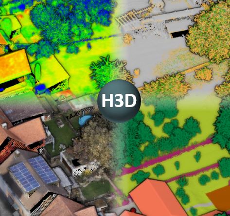
Call for participation - ISPRS Benchmark on Semantic Segmentation of High-Resolution 3D Points and Meshes

The Hessigheim 3D - Benchmark (H3D) on Semantic Segmentation of High-Resolution 3D Point Clouds and Meshes was selected as an ISPRS scientific initiative 2021. The data set consists of both an Unmanned Aerial Vehicle (UAV) laser scanning point cloud and a 3D textured mesh captured at the village of Hessigheim (Germany).

The point cloud features a mean point density of about 800 pts/m² and the oblique imagery used for 3D mesh texturing realizes a ground sampling distance of about 2-3 cm. This enables the identification of fine-grained structures and represents the state of the art in UAV-based mapping.  The respective point clouds are manually labeled into 11 classes and are used to derive labeled textured 3D meshes as an alternative representation.

Ultimately, data sets from three different epochs will be made available, currently the first epoch can be accessed by the benchmark webpage  https://ifpwww.ifp.uni-stuttgart.de/benchmark/hessigheim/default.aspx.

Interested researchers can use these state-of-the-art data sets to test their methods and algorithms on semantic segmentation of 3D point clouds for geospatial applications. Detailed information on the data, the participation and the submission of results for the H3D benchmark is also available in the accompanying paper https://arxiv.org/abs/2102.05346


General Announcements

ISC-GeoUnions      

About the GeoUnions (GUs)
bar

GeoUnions is a network of representatives from the international scientific unions of the International Science Council (ISC) dealing with Earth and space sciences.

The GeoUnions (GUs) is a network of representatives from the international scientific unions of the International Science Council (ISC) dealing with Earth and space sciences. The GUs established a Steering Committee in 2004 (in Paris, France) to promote the sciences worldwide, to communicate and to coordinate the scientific activities of the individual unions, and to speak on behalf of GU members to the ISC Governing Board, ISC Members and its interdisciplinary bodies, and at international level, especially to the United Nations organizations and other global stakeholders. The current Members of the GUs are:

The Steering Committee of GUs normally meets a day before of the ISC General Assemblies and Scientific Unions Meetings of ISC. More information about the GeoUnions, including Working Procedures, can be found at http://www.icsu-geounions.org/ 

ISPRS plays an important role by participating in several joint projects and taking   chair positions. Currently, ISPRS Secretary General Lena Halounová is the Chair of the Steering Committee.   


ISC-GeoUnions      

New Activity: ISC GeoUnions Standing Committee on Disaster Risk Reduction

The GeoUnions Standing Committee on Disaster Risk Reduction (ISC-GU-SC-DRR) was established in July 2020, initiated and lead by Prof. Orhan Altan, who was nominated by the International Science Council (ISC) GeoUnions Steering Committee and ISPRS. The newly established Committee seeks to strengthen the long-standing ISC leadership in advancing DRR.…

Read the report here…

Read the Policy Brief here…

View list of Committee Members here…


Good Practise      

Geospatial Information-enabled SDGs Local Monitoring Featured as Outstanding Good Practice by UN DESA

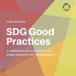
A pilot practice, lead by Prof. Jun Chen (ISPRS Past President), of comprehensive SDGs local monitoring with geospatial information was featured as one of the 16 outstanding examples of SDG implementation across the globe and presented in the new UN DESA booklet publication “SDG Good Practices: A complication of successful stories and lessons learned in SDG Implementation”.

Read more here…


Announcements of Scientific Meetings                (see also ISPRS Calendar)

CRSS-SCT      

The 42nd Canadian Symposium on Remote Sensing

bar

June 21-24, 2021
Yellowknife, Northwest Territories, Canada

A hybrid event that will bring together academics, practitioners, vendors, and policymakers from the Remote Sensing community in an informative and productive five-day event under the theme of Understanding Our World: Remote Sensing for A Sustainable Future. With special sessions, general sessions, Keynotes, panel discussions, and workshops. Attendees will enjoy both technical sessions and networking opportunities, online and those attending on-site, will be enjoying the beautiful City Yellowknife. We hope this will encourage cross disciplinary and cross-cultural engagement as well as the sharing of knowledge derived from a range of scientific and traditional approaches.

For details visit https://crss-sct.ca/conferences/csrs-2021/


BRAUIC      

The 2021 International Student Competition on Architectural Design and Digital Modelling

The Theme of the event is “Modelling: Resilience: To Recreate the Glamour of Canals”, including Architectural Design, Structural Design, Building and Space 3D Modelling. An International Photography Competition on Historic Canal Towns Along the Belt and Road will be part of the event. Award ceremony and work exhibition will be held in October 2021, Mostar, Bosnia and Herzegovina.

For more information see…


COSPAR      

COSPAR 2022 - 44th Scientific Assembly of the Committee on Space Research (COSPAR) and Associated Events

16 – 24 July 2022
Athens, Greece

Contact: cospar@cosparhq.cnes.fr

https://www.cospar-assembly.org

Abstract Deadline: Mid-February 2022


ISPRS International Journal of Geo-Information — Open Access Journal

ISPRS International Journal of Geo-Information — Open Access Journal      

New publications in the ISPRS International Journal of Geo-Information
Open Access Journal
Volume 9, Issue 12 (December 2020)

Performance Evaluation and Comparison of Bivariate Statistical-Based Artificial Intelligence Algorithms for Spatial Prediction of Landslides
Chen, Wei, Sun, Zenghui, Zhao, Xia, Lei, Xinxiang, Shirzadi, Ataollah, Shahabi, Himan
No: 696

Network Characteristics and Vulnerability Analysis of Chinese Railway Network under Earthquake Disasters
Yin, Lingzhi, Wang, Yafei
No: 697

A Coarse-to-Fine Model for Geolocating Chinese Addresses
Qian, Chunyao, Yi, Chao, Cheng, Chengqi, Pu, Guoliang, Liu, Jiashu
No: 698

Modeling Spatial Charging Demands Related to Electric Vehicles for Power Grid Planning Applications
Gauglitz, Philip, Ulffers, Jan, Thomsen, Gyde, Frischmuth, Felix, Geiger, David, Scheidler, Alexander
No: 699

Between Post-Flâneur and Smartphone Zombie: Smartphone Users’ Altering Visual Attention and Walking Behavior in Public Space
Argin, Gorsev, Pak, Burak, Turkoglu, Handan
No: 700

A Theoretical Approach for Forecasting Different Types of Drought Simultaneously, Using Entropy Theory and Machine-Learning Methods
Aghelpour, Pouya, Mohammadi, Babak, Biazar, Seyed Mostafa, Kisi, Ozgur, Sourmirinezhad, Zohreh
No: 701

Applying GIS and Text Mining Methods to Twitter Data to Explore the Spatiotemporal Patterns of Topics of Interest in Kuwait
G. Almatar, Muhammad, Alazmi, Huda S., Li, Liuqing, Fox, Edward A.
No: 702

Developing Versatile Graphic Map Load Metrics
Barvir, Radek, Vozenilek, Vit
No: 705

A Fuzzy Spatial Region Extraction Model for Object’s Vague Location Description from Observer Perspective
Xu, Jun, Pan, Xin
No: 703

A Framework for Classifying Participant Motivation that Considers the Typology of Citizen Science Projects
Lotfian, Maryam, Ingensand, Jens, Brovelli, Maria Antonia
No: 704

Evaluating a Workflow Tool for Simplifying Scenario Planning with the Online WhatIf? Planning Support System
Hussnain, Muhammad Qadeer ul, Waheed, Abdul, Wakil, Khydija, Jabbar, Junaid Abdul, Pettit, Christopher James, Tahir, Ali
No: 706

Spatial Pattern of Construction Land Distribution in Bays along the Coast of Vietnam
Zhang, Junjue, Su, Fenzhen
No: 707

Spatial Determinants of Land Conversion for Various Urban Use: A Case Study of Beijing
Huang, Daquan, Chu, Erxuan, Liu, Tao
No: 708

Case Study on Privacy-Aware Social Media Data Processing in Disaster Management
Löchner, Marc, Fathi, Ramian, Schmid, David ‘-1’, Dunkel, Alexander, Burghardt, Dirk, Fiedrich, Frank, Koch, Steffen
No: 709

Supporting SDG 15, Life on Land: Identifying the Main Drivers of Land Degradation in Honghe Prefecture, China, between 2005 and 2015
Wang, Tuo, Giuliani, Gregory, Lehmann, Anthony, Jiang, Yangming, Shao, Xiaodong, Li, Liping, Zhao, Huihui
No: 710

OurPlaces: Cross-Cultural Crowdsourcing Platform for Location Recommendation Services
Nguyen, Luong Vuong, Jung, Jason J., Hwang, Myunggwon
No: 711

Event Geoparser with Pseudo-Location Entity Identification and Numerical Argument Extraction Implementation and Evaluation in Indonesian News Domain
Dewandaru, Agung, Widyantoro, Dwi Hendratmo, Akbar, Saiful
No: 712

Aerial Bombing Crater Identification: Exploitation of Precise Digital Terrain Models
Dolejš, Martin, Pacina, Jan, Veselý, Martin, Brétt, Dominik
No: 713

Near Relation-Based Indoor Positioning Method under Sparse Wi-Fi Fingerprints
Wang, Yankun, Guo, Renzhong, Wang, Weixi, Li, Xiaoming, Tang, Shengjun, Zhang, Wei, Wang, Luyao, Chen, Liang, Li, You, Xiu, Wenqun
No: 714

Intracity Pandemic Risk Evaluation Using Mobile Phone Data: The Case of Shanghai during COVID-19
Gan, Tian, Li, Weifeng, He, Linghui, Li, Jian
No: 715

Geodiversity Assessment with Crowdsourced Data and Spatial Multicriteria Analysis
Jankowski, Piotr, Najwer, Alicja, Zwoliński, Zbigniew, Niesterowicz, Jacek
No: 716

Design of Multiple Spatial Context Detection Method Considering Elongated Top-Bounded Spaces Based on GPS Signal-To-Noise Ratio and Fuzzy Inference
Tabata, Kenichi, Nakajima, Madoka, Kohtake, Naohiko
No: 717

Spatiotemporal LUCC Simulation under Different RCP Scenarios Based on the BPNN_CA_Markov Model: A Case Study of Bamboo Forest in Anji County
Huang, Zihao, Du, Huaqiang, Li, Xuejian, Zhang, Meng, Mao, Fangjie, Zhu, Di’en, He, Shaobai, Liu, Hua
No: 718

Form Follows Content: An Empirical Study on Symbol-Content (In)Congruences in Thematic Maps
Klettner, Silvia
No: 719

Flood Susceptibility Mapping through the GIS-AHP Technique Using the Cloud
Swain, Kishore Chandra, Singha, Chiranjit, Nayak, Laxmikanta
No: 720

A Multiresolution Vector Data Compression Algorithm Based on Space Division
Liu, Dongge, Wang, Tao, Li, Xiaojuan, Ni, Yeqing, Li, Yanping, Jin, Zhao
No: 721

From Massive Trajectory Data to Traffic Modeling for Better Behavior Prediction in a Usage-Based Insurance Context
Blais, Philippe, Badard, Thierry, Duchesne, Thierry, Côté, Marie-Pier
No: 722

Retraction: Khan, N.U. et al. Spatiotemporal Analysis of Tourists and Residents in Shanghai Based on Location-Based Social Network’s Data from Weibo. ISPRS Int. J. Geo-Inf. 2020, 9, 70
IJGI Editorial Office
No: 723

Spatial Distribution of China’s Industrial Output Values under Global Warming Scenarios RCP4.5 and RCP8.5
Xue, Qian, Song, Wei
No: 724

Multi-Criteria Evaluation (MCE) Method for the Management of Woodland Plantations in Floodplain Areas
Tzioutzios, Christos, Kastridis, Aristeidis
No: 725

Assessment of Changes in Land Use/Land Cover and Land Surface Temperatures and Their Impact on Surface Urban Heat Island Phenomena in the Kathmandu Valley (1988–2018)
Sarif, Md. Omar, Rimal, Bhagawat, Stork, Nigel E.
No: 726

Quality of GNSS Traces from VGI: A Data Cleaning Method Based on Activity Type and User Experience
Àvila Callau, Aitor, Pérez-Albert, Yolanda, Serrano Giné, David
No: 727

A High-Resolution Spatial and Time-Series Labeled Unmanned Aerial Vehicle Image Dataset for Middle-Season Rice
Zhou, Dongbo, Liu, Shuangjian, Yu, Jie, Li, Hao
No: 728

Spatial Dimensions of Female Political Participation: Regional Perspective of Women’s Descriptive Representation in Czech Local Councils, 1994–2018
Maškarinec, Pavel
No: 729

An Adaptive Cutoff Frequency Selection Approach for Fast Fourier Transform Method and Its Application into Short-Term Traffic Flow Forecasting
Wang, Runjie, Shi, Wenzhong, Liu, Xianglei, Li, Zhiyuan
No: 731

Crime Prediction with Historical Crime and Movement Data of Potential Offenders Using a Spatio-Temporal Cokriging Method
Yu, Hongjie, Liu, Lin, Yang, Bo, Lan, Minxuan
No: 732

Characterizing Tourism Destination Image Using Photos’ Visual Content
Xiao, Xin, Fang, Chaoyang, Lin, Hui
No: 730

A Study of User Activity Patterns and the Effect of Venue Types on City Dynamics Using Location-Based Social Network Data
Khan, Naimat Ullah, Wan, Wanggen, Yu, Shui, Muzahid, A. A. M., Khan, Sajid, Hou, Li
No: 733

DEM Void Filling Based on Context Attention Generation Model
Zhang, Chunsen, Shi, Shu, Ge, Yingwei, Liu, Hengheng, Cui, Weihong
No: 734

Combining Satellite Remote Sensing and Climate Data in Species Distribution Models to Improve the Conservation of Iberian White Oaks (Quercus L.)
Vila-Viçosa, Carlos, Arenas-Castro, Salvador, Marcos, Bruno, Honrado, João, García, Cristina, Vázquez, Francisco M., Almeida, Rubim, Gonçalves, João
No: 735

Geographic Information System Technology Combined with Back Propagation Neural Network in Groundwater Quality Monitoring
Sun, Jing, Wang, Genhou
No: 736

A Fuzzy Logic-Based Approach for Modelling Uncertainty in Open Geospatial Data on Landfill Suitability Analysis
Lyimo, Neema Nicodemus, Shao, Zhenfeng, Ally, Ally Mgelwa, Twumasi, Nana Yaw Danquah, Altan, Orhan, Sanga, Camilius A.
No: 737

The Methodology of Creating Variable Resolution Maps Based on the Example of Passability Maps
Pokonieczny, Krzysztof
No: 738

Correlation between Geochemical and Multispectral Patterns in an Area Severely Contaminated by Former Hg-As Mining
Boente, Carlos, Salgado, Lorena, Romero-Macías, Emilio, Colina, Arturo, López-Sánchez, Carlos A., Gallego, José Luis R.
No: 739

Spatial Modeling for Homicide Rates Estimation in Pernambuco State-Brazil
Silva, Carlos, Melo, Silas, Santos, Alex, Junior, Pedro Almeida, Sato, Simone, Santiago, Katarina, Sá, Lucilene
No: 740

Virtual Touring for the Puglia Regional Museum Directorate
Lerario, Antonella, Maiellaro, Nicola
No: 741

Exploring the Attractiveness of Residential Areas for Human Activities Based on Shared E-Bike Trajectory Data
Cheng, Xiaoqian, Du, Weibing, Li, Chengming, Yang, Leiku, Xu, Linjuan
No: 742

Automatic Workflow for Roof Extraction and Generation of 3D CityGML Models from Low-Cost UAV Image-Derived Point Clouds
Murtiyoso, Arnadi, Veriandi, Mirza, Suwardhi, Deni, Soeksmantono, Budhy, Harto, Agung Budi
No: 743

Quantifying the Spatial Heterogeneity and Driving Factors of Aboveground Forest Biomass in the Urban Area of Xi’an, China
Zhao, Xuan, Liu, Jianjun, Hao, Hongke, Yang, Yanzheng
No: 744

Recognition Method of New Address Elements in Chinese Address Matching Based on Deep Learning
Zhang, Hongwei, Ren, Fu, Li, Huiting, Yang, Renfei, Zhang, Shuai, Du, Qingyun
No: 745

Mapping Food and Health Premises in Barcelona. An Approach to Logics of Distribution and Proximity of Essential Urban Services
Crosas, Carles, Gómez-Escoda, Eulàlia
No: 746

A BIM Based Hybrid 3D Indoor Map Model for Indoor Positioning and Navigation
Liu, Jianhua, Luo, Jingyan, Hou, Jiwei, Wen, Danqi, Feng, Guoqiang, Zhang, Xu
No: 747

Flash Flood Susceptibility Assessment Based on Geodetector, Certainty Factor, and Logistic Regression Analyses in Fujian Province, China
Cao, Yifan, Jia, Hongliang, Xiong, Junnan, Cheng, Weiming, Li, Kun, Pang, Quan, Yong, Zhiwei
No: 748

Data Gap Classification for Terrestrial Laser Scanning-Derived Digital Elevation Models
O’Banion, Matthew S., Olsen, Michael J., Hollenbeck, Jeff P., Wright, William C.
No: 749

Analysis of the Temporal Characteristics of the Elderly Traveling by Bus Using Smart Card Data
Shi, Zhicheng, Pun-Cheng, Lilian S. C., Liu, Xintao, Lai, Jianhui, Tong, Chengzhuo, Zhang, Anshu, Zhang, Min, Shi, Wenzhong
No: 751

A Virtual Reality Simulation Method for Crowd Evacuation in a Multiexit Indoor Fire Environment
Guo, Yukun, Zhu, Jun, Wang, Yu, Chai, Jinchuan, Li, Weilian, Fu, Lin, Xu, Bingli, Gong, Yuhang
No: 750

Opportunities and Challenges of Geospatial Analysis for Promoting Urban Livability in the Era of Big Data and Machine Learning
Kovacs-Györi, Anna, Ristea, Alina, Havas, Clemens, Mehaffy, Michael, Hochmair, Hartwig H., Resch, Bernd, Juhasz, Levente, Lehner, Arthur, Ramasubramanian, Laxmi, Blaschke, Thomas
No: 752

Towards Self-Service GIS—Combining the Best of the Semantic Web and Web GIS
Rowland, Alexandra, Folmer, Erwin, Beek, Wouter
No: 753

The Land Use Mapping Techniques (Including the Areas Used by Pedestrians) Based on Low-Level Aerial Imagery
Smaczyński, Maciej, Medyńska-Gulij, Beata, Halik, Łukasz
No: 754

Infrastructure of the Spatial Information in the European Community (INSPIRE) Based on Examples of Italy and Poland
Ogryzek, Marek, Tarantino, Eufemia, Rząsa, Krzysztof
No: 755

Understanding Spatiotemporal Variations of Ridership by Multiple Taxi Services
Zhang, Wenbo, Xi, Yinfei, Ukkusuri, Satish V.
No: 757

Identifying Port Calls of Ships by Uncertain Reasoning with Trajectory Data
Wu, Lin, Xu, Yongjun, Wang, Fei
No: 756

Deep Learning for Detecting and Classifying Ocean Objects: Application of YoloV3 for Iceberg–Ship Discrimination
Hass, Frederik Seerup, Jokar Arsanjani, Jamal
No: 758

An Efficient Probabilistic Registration Based on Shape Descriptor for Heritage Field Inspection
Zang, Yufu, Li, Bijun, Xiao, Xiongwu, Zhu, Jianfeng, Meng, Fancong
No: 759

Structural Elements Detection and Reconstruction (SEDR): A Hybrid Approach for Modeling Complex Indoor Structures
Wu, Ke, Shi, Wenzhong, Ahmed, Wael
No: 760

Adjusting the Regular Network of Squares Resolution to the Digital Terrain Model Surface Shape
Gościewski, Dariusz, Gerus-Gościewska, Małgorzata
No: 761

The Correlation between the Jobs–Housing Relationship and the Innovative Development of Sci-Tech Parks in New Urban Districts: A Case Study of the Hangzhou West Hi-Tech Corridor in China
Wu, Yue, Yang, Yue, Chen, Qiuxiao, Xu, Weishun
No: 762

Local Segregation of Realised Niches in Lizards
Sillero, Neftalí, Argaña, Elena, Matos, Cátia, Franch, Marc, Kaliontzopoulou, Antigoni, Carretero, Miguel A.
No: 764

Participatory Rural Spatial Planning Based on a Virtual Globe-Based 3D PGIS
Yu, Linjun, Zhang, Xiaotong, He, Feng, Liu, Yalan, Wang, Dacheng
No: 763


New publications in the ISPRS International Journal of Geo-Information
Open Access Journal
Volume 10, Issue 01 (January 2021)

GeoFairy2: A Cross-Institution Mobile Gateway to Location-Linked Data for In-Situ Decision Making
Sun, Ziheng, Di, Liping, Cvetojevic, Sreten, Yu, Zhiqi
No: 1

A Person-to-Person and Person-to-Place COVID-19 Contact Tracing System Based on OGC IndoorGML
Ojagh, Soroush, Saeedi, Sara, Liang, Steve H. L.
No: 2

Radio Base Stations and Electromagnetic Fields: GIS Applications and Models for Identifying Possible Risk Factors and Areas Exposed. Some Exemplifications in Rome
Pesaresi, Cristiano, Pavia, Davide
No: 3

Identifying Complex Junctions in a Road Network
Yang, Jianting, Zhao, Kongyang, Li, Muzi, Xu, Zhu, Li, Zhilin
No: 4

Research on Large-Scale Urban Shrinkage and Expansion in the Yellow River Affected Area Using Night Light Data
Niu, Wenhui, Xia, Haoming, Wang, Ruimeng, Pan, Li, Meng, Qingmin, Qin, Yaochen, Li, Rumeng, Zhao, Xiaoyang, Bian, Xiqing, Zhao, Wei
No: 5

Indoor Floor Localization Based on Multi-Intelligent Sensors
Zhao, Min, Qin, Danyang, Guo, Ruolin, Wang, Xinxin
No: 6

Accessible Routes Integrating Data from Multiple Sources
Luaces, Miguel R., Fisteus, Jesús A., Sánchez-Fernández, Luis, Munoz-Organero, Mario, Balado, Jesús, Díaz-Vilariño, Lucía, Lorenzo, Henrique
No: 7

Independent Map Enhancement for a Spatial Road Network: Fundamental Applications and Opportunities
Alamri, Sultan
No: 8

A Theoretical Proposition for Spatial Data Infrastructure On-Going Improvement
Maphale, Lopang, Smit, Julian L.
No: 9

A Critical Comparison of 3D Digitization Techniques for Heritage Objects
Adamopoulos, Efstathios, Rinaudo, Fulvio, Ardissono, Liliana
No: 10

Identification of Poverty Areas by Remote Sensing and Machine Learning: A Case Study in Guizhou, Southwest China
Yin, Jian, Qiu, Yuanhong, Zhang, Bin
No: 11

Knowledge Discovery Web Service for Spatial Data Infrastructures
Omidipoor, Morteza, Toomanian, Ara, Neysani Samany, Najmeh, Mansourian, Ali
No: 12

A Review of Human Mobility Research Based on Big Data and Its Implication for Smart City Development
Wang, Anqi, Zhang, Anshu, Chan, Edwin H. W., Shi, Wenzhong, Zhou, Xiaolin, Liu, Zhewei
No: 13

Understanding the Correlation between Landscape Pattern and Vertical Urban Volume by Time-Series Remote Sensing Data: A Case Study of Melbourne
Ge, Mengyu, Fang, Shenghui, Gong, Yan, Tao, Pengjie, Yang, Guang, Gong, Wenbing
No: 14

A Refined Lines/Regions and Lines/Lines Topological Relations Model Based on Whole-Whole Objects Intersection Components
Zhou, Xiaoguang, He, Hongyuan, Hou, Dongyang, Li, Rui, Zheng, Heng
No: 15

Simulation of the Urban Jobs–Housing Location Selection and Spatial Relationship Using a Multi-Agent Approach
Wang, Huihui, Zeng, Weihua, Cao, Ruoxin
No: 16

Reconstruction of Multi-Temporal Satellite Imagery by Coupling Variational Segmentation and Radiometric Analysis
Case, Nicola, Vitti, Alfonso
No: 17

The Effect of Environmental Conditions on the Quality of UAS Orthophoto-Maps in the Coastal Environment
Doukari, Michaela, Katsanevakis, Stelios, Soulakellis, Nikolaos, Topouzelis, Konstantinos
No: 18

Determining Cover Management Factor with Remote Sensing and Spatial Analysis for Improving Long-Term Soil Loss Estimation in Watersheds
Tsai, Fuan, Lai, Jhe-Syuan, Nguyen, Kieu Anh, Chen, Walter
No: 19

A Tourist Attraction Recommendation Model Fusing Spatial, Temporal, and Visual Embeddings for Flickr-Geotagged Photos
Han, Shanshan, Liu, Cuiming, Chen, Keyun, Gui, Dawei, Du, Qingyun
No: 20

Analysis of Differences in the Spatial Distribution among Terrestrial Mammals Using Geodetector—A Case Study of China
Chi, Yao, Qian, Tianlu, Sheng, Caiying, Xi, Changbai, Wang, Jiechen
No: 21

Residual Multi-Attention Classification Network for A Forest Dominated Tropical Landscape Using High-Resolution Remote Sensing Imagery
Yu, Tong, Wu, Wenjin, Gong, Chen, Li, Xinwu
No: 22

Deep Learning-Based Generation of Building Stock Data from Remote Sensing for Urban Heat Demand Modeling
Wurm, Michael, Droin, Ariane, Stark, Thomas, Geiß, Christian, Sulzer, Wolfgang, Taubenböck, Hannes
No: 23

Open Community-Based Crowdsourcing Geoportal for Earth Observation Products: A Model Design and Prototype Implementation
Vahidnia, Mohammad H., Vahidi, Hossein
No: 24

An Examination of People’s Privacy Concerns, Perceptions of Social Benefits, and Acceptance of COVID-19 Mitigation Measures That Harness Location Information: A Comparative Study of the U.S. and South Korea
Kim, Junghwan, Kwan, Mei-Po
No: 25

Pairwise Coarse Registration of Indoor Point Clouds Using 2D Line Features
Li, Zhen, Zhang, Xiaoming, Tan, Junxiang, Liu, Hua
No: 26

Torrential Flood Water Management: Rainwater Harvesting through Relation Based Dam Suitability Analysis and Quantification of Erosion Potential
Munir, Bilal Ahmad, Ahmad, Sajid Rashid, Rehan, Raja
No: 27

Sensitivity Assessment of Spatial Resolution Difference in DEM for Soil Erosion Estimation Based on UAV Observations: An Experiment on Agriculture Terraces in the Middle Hill of Nepal
Chidi, Chhabi Lal, Zhao, Wei, Chaudhary, Suresh, Xiong, Donghong, Wu, Yanhong
No: 28

Rapid Evaluation and Validation Method of Above Ground Forest Biomass Estimation Using Optical Remote Sensing in Tundi Reserved Forest Area, India
Kumar, Praveen, Krishna, Akhouri P., Rasmussen, Thorkild M., Pal, Mahendra K.
No: 29

Geospatial Open Data Usage and Metadata Quality
Quarati, Alfonso, De Martino, Monica, Rosim, Sergio
No: 30

PM2.5 Estimation and Spatial-Temporal Pattern Analysis Based on the Modified Support Vector Regression Model and the 1 km Resolution MAIAC AOD in Hubei, China
Chen, Nengcheng, Yang, Meijuan, Du, Wenying, Huang, Min
No: 31

Semantics-Driven Remote Sensing Scene Understanding Framework for Grounded Spatio-Contextual Scene Descriptions
Potnis, Abhishek V., Durbha, Surya S., Shinde, Rajat C.
No: 32

Temporal and Spatial Variations in the Leaf Area Index and Its Response to Topography in the Three-River Source Region, China from 2000 to 2017
Zhang, Wenqi, Jin, Huaan, Shao, Huaiyong, Li, Ainong, Li, Shangzhi, Fan, Wenjie
No: 33

AIRSENSE-TO-ACT: A Concept Paper for COVID-19 Countermeasures Based on Artificial Intelligence Algorithms and Multi-Source Data Processing
Sebastianelli, Alessandro, Mauro, Francesco, Di Cosmo, Gianluca, Passarini, Fabrizio, Carminati, Marco, Ullo, Silvia Liberata
No: 34

A Blockchain Solution for Securing Real Property Transactions: A Case Study for Serbia
Sladić, Goran, Milosavljević, Branko, Nikolić, Siniša, Sladić, Dubravka, Radulović, Aleksandra
No: 35

Incorporating Memory-Based Preferences and Point-of-Interest Stickiness into Recommendations in Location-Based Social Networks
Zhang, Hang, Gan, Mingxin, Sun, Xi
No: 36

Spatially Characterizing Major Airline Alliances: A Network Analysis
Chan, Chun-Hsiang, Chu, Tzu-How, Wu, Jiun-Huei Proty, Wen, Tzai-Hung
No: 37

Using Restaurant POI Data to Explore Regional Structure of Food Culture Based on Cuisine Preference
Jiang, Shangjing, Zhang, Haiping, Wang, Haoran, Zhou, Lei, Tang, Guoan
No: 38

FuNet: A Novel Road Extraction Network with Fusion of Location Data and Remote Sensing Imagery
Zhou, Kai, Xie, Yan, Gao, Zhan, Miao, Fang, Zhang, Lei
No: 39

Traffic Inequality and Relations in Maritime Silk Road: A Network Flow Analysis
Mou, Naixia, Ren, Haonan, Zheng, Yunhao, Chen, Jinhai, Niu, Jiqiang, Yang, Tengfei, Zhang, Lingxian, Liu, Feng
No: 40

The Potential of LiDAR and UAV-Photogrammetric Data Analysis to Interpret Archaeological Sites: A Case Study of Chun Castle in South-West England
Kadhim, Israa, Abed, Fanar M.
No: 41

Comparison of Ensemble Machine Learning Methods for Soil Erosion Pin Measurements
Nguyen, Kieu Anh, Chen, Walter, Lin, Bor-Shiun, Seeboonruang, Uma
No: 42


New publications in the ISPRS International Journal of Geo-Information
Open Access Journal
Volume 10, Issue 02 (February 2021)

Watershed Drought and Ecosystem Services: Spatiotemporal Characteristics and Gray Relational Analysis
Bai, Jizhou, Zhou, Zixiang, Zou, Yufeng, Pulatov, Bakhtiyor, Siddique, Kadambot H. M.
No: 43

Estimating the Impacts of Proximity to Public Transportation on Residential Property Values: An Empirical Analysis for Hartford and Stamford Areas, Connecticut
Zhang, Bo, Li, Weidong, Lownes, Nicholas, Zhang, Chuanrong
No: 44

Study on Fractal Characteristics of Migration-Population Flow—Evidence from Egypt
Zhao, Sidong, Wang, Xingping, Ma, Zhishan
No: 45

Crowdsourcing without Data Bias: Building a Quality Assurance System for Air Pollution Symptom Mapping
Samulowska, Marta, Chmielewski, Szymon, Raczko, Edwin, Lupa, Michał, Myszkowska, Dorota, Zagajewski, Bogdan
No: 46

A National Examination of the Spatial Extent and Similarity of Offenders’ Activity Spaces Using Police Data
Curtis-Ham, Sophie, Bernasco, Wim, Medvedev, Oleg N., Polaschek, Devon L. L.
No: 47

Evaluation Methods for Citizen Design Science Studies: How Do Planners and Citizens Obtain Relevant Information from Map-Based E-Participation Tools?
Müller, Johannes
No: 48

Acknowledgement to Reviewers of IJGI in 2020
IJGI Editorial Office
No: 49

ArcStereoNet: A New ArcGIS® Toolbox for Projection and Analysis of Meso- and Micro-Structural Data
Ortolano, Gaetano, D’Agostino, Alberto, Pagano, Mario, Visalli, Roberto, Zucali, Michele, Fazio, Eugenio, Alsop, Ian, Cirrincione, Rosolino
No: 50

Micro-Fabric Analyzer (MFA): A New Semiautomated ArcGIS-Based Edge Detector for Quantitative Microstructural Analysis of Rock Thin-Sections
Visalli, Roberto, Ortolano, Gaetano, Godard, Gaston, Cirrincione, Rosolino
No: 51

Linking Geosocial Sensing with the Socio-Demographic Fabric of Smart Cities
Ostermann, Frank O.
No: 52

Spatial Patterns of COVID-19 Incidence in Relation to Crime Rate Across London
Sun, Yeran, Huang, Ying, Yuan, Ke, Chan, Ting On, Wang, Yu
No: 53

A Perception Model for Optimizing and Evaluating Evacuation Guidance Systems
Huang, Lin, Gong, Jianhua, Li, Wenhang
No: 54

Versioning of 3D City Models for Municipality Applications: Needs, Obstacles and Recommendations
Eriksson, Helen, Harrie, Lars
No: 55

DEM Based Study on Shielded Astronomical Solar Radiation and Possible Sunshine Duration under Terrain Influences on Mars by Using Spectral Methods
Lin, Siwei, Chen, Nan
No: 56

Joint Promotion Partner Recommendation Systems Using Data from Location-Based Social Networks
Chen, Yi-Chung, Huang, Hsi-Ho, Chiu, Sheng-Min, Lee, Chiang
No: 57

Mapping Allochemical Limestone Formations in Hazara, Pakistan Using Google Cloud Architecture: Application of Machine-Learning Algorithms on Multispectral Data
Khan, Muhammad Fawad Akbar, Muhammad, Khan, Bashir, Shahid, Ud Din, Shahab, Hanif, Muhammad
No: 58

New Insight on Soil Loss Estimation in the Northwestern Region of the Zagros Fold and Thrust Belt
Othman, Arsalan Ahmed, Obaid, Ahmed K., Al-Manmi, Diary Ali Mohammed Amin, Al-Maamar, Ahmed F., Hasan, Syed E., Liesenberg, Veraldo, Shihab, Ahmed T., Al-Saady, Younus I.
No: 59

Mitigating Urban Visual Pollution through a Multistakeholder Spatial Decision Support System to Optimize Locational Potential of Billboards
Wakil, Khydija, Tahir, Ali, Hussnain, Muhammad Qadeer ul, Waheed, Abdul, Nawaz, Raheel
No: 60

Integrating a Three-Level GIS Framework and a Graph Model to Track, Represent, and Analyze the Dynamic Activities of Tidal Flats
Xu, Chao, Liu, Weibo
No: 61

Machine Learning Approaches to Bike-Sharing Systems: A Systematic Literature Review
Albuquerque, Vitória, Sales Dias, Miguel, Bacao, Fernando
No: 62

Big Data Supported the Identification of Urban Land Efficiency in Eurasia by Indicator SDG 11.3.1
Li, Chaopeng, Cai, Guoyin, Du, Mingyi
No: 64

A GIS-Based System for Spatial-Temporal Availability Evaluation of the Open Spaces Used as Emergency Shelters: The Case of Victoria, British Columbia, Canada
Yao, Yibing, Zhang, Yuyang, Yao, Taoyu, Wong, Kapo, Tsou, Jin Yeu, Zhang, Yuanzhi
No: 63

User-Specific Route Planning for People with Motor Disabilities: A Fuzzy Approach
Gharebaghi, Amin, Mostafavi, Mir-Abolfazl, Edwards, Geoffrey, Fougeyrollas, Patrick
No: 65

A Multiple Subspaces-Based Model: Interpreting Urban Functional Regions with Big Geospatial Data
Zhu, Jiawei, Tao, Chao, Lin, Xin, Peng, Jian, Huang, Haozhe, Chen, Li, Wang, Qiongjie
No: 66

Discovering Spatial-Temporal Indication of Crime Association (STICA)
Jiang, Chao, Liu, Lin, Qin, Xiaoxing, Zhou, Suhong, Liu, Kai
No: 67

Techniques for the Automatic Detection and Hiding of Sensitive Targets in Emergency Mapping Based on Remote Sensing Data
Qiu, Tianqi, Liang, Xiaojin, Du, Qingyun, Ren, Fu, Lu, Pengjie, Wu, Chao
No: 68

Do Different Map Types Support Map Reading Equally? Comparing Choropleth, Graduated Symbols, and Isoline Maps for Map Use Tasks
Słomska-Przech, Katarzyna, Gołębiowska, Izabela Małgorzata
No: 69

Study on an Artificial Society of Urban Safety Livability Change
Pan, Lihu, Zhang, Le, Qin, Shipeng, Yan, Huimin, Peng, Rui, Li, Fen
No: 70

Research on the Method of Urban Jobs-Housing Space Recognition Combining Trajectory and POI Data
Zhang, Ya, Liu, Jiping, Wang, Yong, Cao, Yungang, Bai, Youda
No: 71

Evaluation of Urban Vibrancy and Its Relationship with the Economic Landscape: A Case Study of Beijing
Jia, Chen, Liu, Yuefeng, Du, Yunyan, Huang, Jianfeng, Fei, Teng
No: 72

Comparative Analysis of Geolocation Information through Mobile-Devices under Different COVID-19 Mobility Restriction Patterns in Spain
Pérez-Arnal, Raquel, Conesa, David, Alvarez-Napagao, Sergio, Suzumura, Toyotaro, Català, Martí, Alvarez-Lacalle, Enrique, Garcia-Gasulla, Dario
No: 73

Spationomy Simulation Game—Playful Learning in Spatial Economy Higher Education
Pászto, Vít, Pánek, Jiří, Glas, René, van Vught, Jasper
No: 74

Multiscale Spatial Polygonal Object Granularity Factor Matching Method Based on BPNN
Zhu, Daoye, Cheng, Chengqi, Zhai, Weixin, Li, Yihang, Li, Shizhong, Chen, Bo
No: 75

Impact of Urban Land-Cover Changes on the Spatial-Temporal Land Surface Temperature in a Tropical City of Mexico
Palafox-Juárez, Erika Betzabeth, López-Martínez, Jorge Omar, Hernández-Stefanoni, José Luis, Hernández-Nuñez, Héctor
No: 76

Exploring the Influence of E-Hailing Applications on the Taxi Industry—From the Perspective of the Drivers
Gan, Yitong, Fan, Hongchao, Jiao, Wei, Sun, Mengqi
No: 77

Privacy-Preserving Trajectory Data Publishing by Dynamic Anonymization with Bounded Distortion
Li, Songyuan, Tian, Hui, Shen, Hong, Sang, Yingpeng
No: 78

Development of Multilayer-Based Map Matching to Enhance Performance in Large Truck Fleet Dispatching
Mu, Ching-Yun, Chou, Tien-Yin, Hoang, Thanh Van, Kung, Pin, Fang, Yao-Min, Chen, Mei-Hsin, Yeh, Mei-Ling
No: 79

Lost Person Search Area Prediction Based on Regression and Transfer Learning Models
Šerić, Ljiljana, Pinjušić, Tomas, Topić, Karlo, Blažević, Tomislav
No: 80

Design and Development of an Internet of Smart Cameras Solution for Complex Event Detection in COVID-19 Risk Behaviour Recognition
Honarparvar, Sepehr, Saeedi, Sara, Liang, Steve, Squires, Jeremy
No: 81

Mixed Reality Flood Visualizations: Reflections on Development and Usability of Current Systems
Rydvanskiy, Ruslan, Hedley, Nick
No: 82

Performance and Productivity of Regional Air Transport Systems in China
Song, Mingli, Jia, Guangshe
No: 83

Spatial Variability of Rainfall Trends in Sri Lanka from 1989 to 2019 as an Indication of Climate Change
Alahacoon, Niranga, Edirisinghe, Mahesh
No: 84

Digital Graphic Documentation and Architectural Heritage: Deformations in a 16th-Century Ceiling of the Pinelo Palace in Seville (Spain)
Reinoso-Gordo, Juan Francisco, Gámiz-Gordo, Antonio, Barrero-Ortega, Pedro
No: 85

Spatiotemporal Dynamics of Suspended Sediments in the Negro River, Amazon Basin, from In Situ and Sentinel-2 Remote Sensing Data
Marinho, Rogério Ribeiro, Harmel, Tristan, Martinez, Jean-Michel, Filizola Junior, Naziano Pantoja
No: 86

A Data Cube Metamodel for Geographic Analysis Involving Heterogeneous Dimensions
Kasprzyk, Jean-Paul, Devillet, Guénaël
No: 87

Simulating Spatio-Temporal Patterns of Bicycle Flows with an Agent-Based Model
Kaziyeva, Dana, Loidl, Martin, Wallentin, Gudrun
No: 88

IdroGEO: A Collaborative Web Mapping Application Based on REST API Services and Open Data on Landslides and Floods in Italy
Iadanza, Carla, Trigila, Alessandro, Starace, Paolo, Dragoni, Alessio, Biondo, Tommaso, Roccisano, Marco
No: 89

A New Approach to Measuring the Similarity of Indoor Semantic Trajectories
Zhu, Jin, Cheng, Dayu, Zhang, Weiwei, Song, Ci, Chen, Jie, Pei, Tao
No: 90

Production, Validation and Morphometric Analysis of a Digital Terrain Model for Lake Trichonis Using Geospatial Technologies and Hydroacoustics
Perivolioti, Triantafyllia-Maria, Mouratidis, Antonios, Terzopoulos, Dimitrios, Kalaitzis, Panagiotis, Ampatzidis, Dimitrios, Tušer, Michal, Frouzova, Jaroslava, Bobori, Dimitra
No: 91

A Fine-Scale Mangrove Map of China Derived from 2-Meter Resolution Satellite Observations and Field Data
Zhang, Tao, Hu, Shanshan, He, Yun, You, Shucheng, Yang, Xiaomei, Gan, Yuhang, Liu, Aixia
No: 92

A Novel Hybrid Method for Landslide Susceptibility Mapping-Based GeoDetector and Machine Learning Cluster: A Case of Xiaojin County, China
Xie, Wei, Li, Xiaoshuang, Jian, Wenbin, Yang, Yang, Liu, Hongwei, Robledo, Luis F., Nie, Wen
No: 93

Geoinformation Technologies in Support of Environmental Hazards Monitoring under Climate Change: An Extensive Review
Tsatsaris, Andreas, Kalogeropoulos, Kleomenis, Stathopoulos, Nikolaos, Louka, Panagiota, Tsanakas, Konstantinos, Tsesmelis, Demetrios E., Krassanakis, Vassilios, Petropoulos, George P., Pappas, Vasilis, Chalkias, Christos
No: 94

The Intensity of Urban Sprawl in Poland
Lityński, Piotr
No: 95

Mini-Map for Gamers Who Walk and Teleport in a Virtual Stronghold
Zagata, Krzysztof, Gulij, Jacek, Halik, Łukasz, Medyńska-Gulij, Beata
No: 96

Framework for Indoor Elements Classification via Inductive Learning on Floor Plan Graphs
Song, Jaeyoung, Yu, Kiyun
No: 97

Passive Mobile Data for Studying Seasonal Tourism Mobilities: An Application in a Mediterranean Coastal Destination
Zaragozí, Benito, Trilles, Sergio, Gutiérrez, Aaron
No: 98

Artificial Neural Network Model Development to Predict Theft Types in Consideration of Environmental Factors
Kwon, Eunseo, Jung, Sungwon, Lee, Jaewook
No: 99

Practical Efficient Regional Land-Use Planning Using Constrained Multi-Objective Genetic Algorithm Optimization
Pan, Tingting, Zhang, Yu, Su, Fenzhen, Lyne, Vincent, Cheng, Fei, Xiao, Han
No: 100

Urban Growth, Real Estate Development and Indigenous Property: Simulating the Expansion Process in the City of Temuco, Chile
Maturana, Francisco, Morales, Mauricio, Peña-Cortés, Fernando, Peña, Marco A., Vielma, Carlos
No: 101

Machine Learning-Based Processing Proof-of-Concept Pipeline for Semi-Automatic Sentinel-2 Imagery Download, Cloudiness Filtering, Classifications, and Updates of Open Land Use/Land Cover Datasets
Řezník, Tomáš, Chytrý, Jan, Trojanová, Kateřina
No: 102

Escaping from Cities during the COVID-19 Crisis: Using Mobile Phone Data to Trace Mobility in Finland
Willberg, Elias, Järv, Olle, Väisänen, Tuomas, Toivonen, Tuuli
No: 103

Modeling of the German Wind Power Production with High Spatiotemporal Resolution
Lehneis, Reinhold, Manske, David, Thrän, Daniela
No: 104

A Zonal Displacement Approach via Grid Point Weighting in Building Generalization
Sahbaz, Kadir, Basaraner, Melih
No: 105

↑ Up


ISPRS Journal of Photogrammetry and Remote Sensing

ISPRS Journal of Photogrammetry and Remote Sensing      

New publications in the ISPRS Journal of Photogrammetry and Remote Sensing Volume 171 (January 2021)

Editorial Board
Pages: ii

Fully convolutional recurrent networks for multidate crop recognition from multitemporal image sequences
Jorge Andres {Chamorro Martinez}, Laura Elena {Cué La Rosa}, Raul Queiroz Feitosa, Ieda Del’Arco Sanches, Patrick Nigri Happ
Pages: 188-201

Laplacian fusion approach of multi-source point clouds for detail enhancement
Shiming Li, Xuming Ge, Han Hu, Qing Zhu
Pages: 385-396

Three-dimensional photogrammetry with deep learning instance segmentation to extract berry fruit harvestability traits
Xueping Ni, Changying Li, Huanyu Jiang, Fumiomi Takeda
Pages: 297-309

Robust line segment matching across views via ranking the line-point graph
Dong Wei, Yongjun Zhang, Xinyi Liu, Chang Li, Zhuofan Li
Pages: 49-62

Automatic 3D building reconstruction from multi-view aerial images with deep learning
Dawen Yu, Shunping Ji, Jin Liu, Shiqing Wei
Pages: 155-170

A cross-correction LiDAR SLAM method for high-accuracy 2D mapping of problematic scenario
Shoujun Jia, Chun Liu, Hangbin Wu, Doudou Zeng, Mengchi Ai
Pages: 367-384

Individual tree detection and crown delineation from Unmanned Aircraft System (UAS) LiDAR in structurally complex mixed species eucalypt forests
D. Jaskierniak, A. Lucieer, G. Kuczera, D. Turner, P.N.J. Lane, R.G. Benyon, S. Haydon
Pages: 171-187

Kernel low-rank representation with elastic net for China coastal wetland land cover classification using GF-5 hyperspectral imagery
Hongjun Su, Wenjing Yao, Zhaoyue Wu, Pan Zheng, Qian Du
Pages: 238-252

From local to global: A transfer learning-based approach for mapping poplar plantations at national scale using Sentinel-2
Yousra Hamrouni, Eric Paillassa, Véronique Chéret, Claude Monteil, David Sheeren
Pages: 76-100

Analysis of the temporal correlations of TLS range observations from plane fitting residuals
Gaël Kermarrec, Michael Lösler, Jens Hartmann
Pages: 119-132

Missing data reconstruction in VHR images based on progressive structure prediction and texture generation
Hanwen Xu, Xinming Tang, Bo Ai, Xiaoming Gao, Fanlin Yang, Zhen Wen
Pages: 266-277

Cascaded multi-baseline interferometry with bistatic TerraSAR-X/TanDEM-X observations for DEM generation
Yuting Dong, Lu Zhang, Houjun Jiang, Timo Balz, Mingsheng Liao
Pages: 224-237

Lidar sheds new light on plant phenomics for plant breeding and management: Recent advances and future prospects
Shichao Jin, Xiliang Sun, Fangfang Wu, Yanjun Su, Yumei Li, Shiling Song, Kexin Xu, Qin Ma, Frédéric Baret, Dong Jiang, Yanfeng Ding, Qinghua Guo
Pages: 202-223

Exploring Google Street View with deep learning for crop type mapping
Yulin Yan, Youngryel Ryu
Pages: 278-296

A review of image fusion techniques for pan-sharpening of high-resolution satellite imagery
Farzaneh {Dadrass Javan}, Farhad Samadzadegan, Soroosh Mehravar, Ahmad Toosi, Reza Khatami, Alfred Stein
Pages: 101-117

Corrigendum to “Improved estimates of monthly land surface temperature from MODIS using a diurnal temperature cycle (DTC) model” [ISPRS J. Photogramm. Remote Sens. 168 (2020) 131–140]
Leiqiu Hu, Ying Sun, Gavin Collins, Peng F
Pages: 118

Unmixing-based Sentinel-2 downscaling for urban land cover mapping
Fei Xu, Ben Somers
Pages: 133-154

Aleatoric uncertainty estimation for dense stereo matching via CNN-based cost volume analysis
Max Mehltretter, Christian Heipke
Pages: 63-75

Land surface phenology as indicator of global terrestrial ecosystem dynamics: A systematic review
Jose A. Caparros-Santiago, Victor Rodriguez-Galiano, Jadunandan Dash
Pages: 330-347

Improving traffic sign recognition results in urban areas by overcoming the impact of scale and rotation
R. Yazdan, M. Varshosaz
Pages: 18-35

Improving hyperspectral image segmentation by applying inverse noise weighting and outlier removal for optimal scale selection
Phuong D. Dao, Kiran Mantripragada, Yuhong He, Faisal Z. Qureshi
Pages: 348-366

Monitoring tree-crown scale autumn leaf phenology in a temperate forest with an integration of PlanetScope and drone remote sensing observations
Shengbiao Wu, Jing Wang, Zhengbing Yan, Guangqin Song, Yang Chen, Qin Ma, Meifeng Deng, Yuntao Wu, Yingyi Zhao, Zhengfei Guo, Zuoqiang Yuan, Guanhua Dai, Xiangtao Xu, Xi Yang, Yanjun Su, Lingli Liu, Jin Wu
Pages: 36-48

Developing a spectral angle based vegetation index for detecting the early dying process of Chinese fir trees
Zhuo Zang, Guangxing Wang, Hui Lin, Peng Luo
Pages: 253-265

Universal SAR and optical image registration via a novel SIFT framework based on nonlinear diffusion and a polar spatial-frequency descriptor
Qiuze Yu, Dawen Ni, Yuxuan Jiang, Yuxuan Yan, Jiachun An, Tao Sun
Pages: 1-17

Robust global registration of point clouds by closed-form solution in the frequency domain
Rong Huang, Yusheng Xu, Wei Yao, Ludwig Hoegner, Uwe Stilla
Pages: 310-329


bar

New publications in the ISPRS Journal of Photogrammetry and Remote Sensing Volume 172 (February 2021)

SceneNet: Remote sensing scene classification deep learning network using multi-objective neural evolution architecture search
Ailong Ma, Yuting Wan, Yanfei Zhong, Junjue Wang, Liangpei Zhang
Pages: 171-188

Combining graph-cut clustering with object-based stem detection for tree segmentation in highly dense airborne lidar point clouds
Sebastian Dersch, Marco Heurich, Nina Krueger, Peter Krzystek
Pages: 207-222

Digital surface model generation for drifting Arctic sea ice with low-textured surfaces based on drone images
Jae-In Kim, Chang-Uk Hyun, Hyangsun Han, Hyun-Cheol Kim
Pages: 147-159

Spruce budworm tree host species distribution and abundance mapping using multi-temporal Sentinel-1 and Sentinel-2 satellite imagery
Rajeev Bhattarai, Parinaz Rahimzadeh-Bajgiran, Aaron Weiskittel, Aaron Meneghini, David A. MacLean
Pages: 28-40

Tropical forest canopy height estimation from combined polarimetric SAR and LiDAR using machine-learning
Maryam Pourshamsi, Junshi Xia, Naoto Yokoya, Mariano Garcia, Marco Lavalle, Eric Pottier, Heiko Balzter
Pages: 79-94

Automated iceberg tracking with a machine learning approach applied to SAR imagery: A Weddell sea case study
Mauro M. Barbat, Thomas Rackow, Christine Wesche, Hartmut H. Hellmer, Mauricio M. Mata
Pages: 189-206

Radiometric correction of laser scanning intensity data applied for terrestrial laser scanning
Nathan Sanchiz-Viel, Estelle Bretagne, El Mustapha Mouaddib, Pascal Dassonvalle
Pages: 1-16

An anchor-based graph method for detecting and classifying indoor objects from cluttered 3D point clouds
Fei Su, Haihong Zhu, Taoyi Chen, Lin Li, Fan Yang, Huixiang Peng, Lei Tang, Xinkai Zuo, Yifan Liang, Shen Ying
Pages: 114-131

Multi-directional change detection between point clouds
Jack G. Williams, Katharina Anders, Lukas Winiwarter, Vivien Zahs, Bernhard Höfle
Pages: 95-113

AMENet: Attentive Maps Encoder Network for trajectory prediction
Hao Cheng, Wentong Liao, Michael Ying Yang, Bodo Rosenhahn, Monika Sester
Pages: 253-266

A novel surface water index using local background information for long term and large-scale Landsat images
Linrong Li, Hongjun Su, Qian Du, Taixia Wu
Pages: 59-78

Per-pixel land cover accuracy prediction: A random forest-based method with limited reference sample data
Hamid Ebrahimy, Babak Mirbagheri, Ali Akbar Matkan, Mohsen Azadbakht
Pages: 17-27

Comprehensive time-series analysis of bridge deformation using differential satellite radar interferometry based on Sentinel-1
Matthias Schlögl, Barbara Widhalm, Michael Avian
Pages: 132-146

Quality-based registration refinement of airborne LiDAR and photogrammetric point clouds
I. Toschi, E.M. Farella, M. Welponer, F. Remondino
Pages: 160-170

Robust line feature matching based on pair-wise geometric constraints and matching redundancy
Jingxue Wang, Qing Zhu, Suyan Liu, Weixi Wang
Pages: 41-58

GTP-PNet: A residual learning network based on gradient transformation prior for pansharpening
Hao Zhang, Jiayi Ma
Pages: 223-239

Deep regression for LiDAR-based localization in dense urban areas
Shangshu Yu, Cheng Wang, Zenglei Yu, Xin Li, Ming Cheng, Yu Zang
Pages: 240-252


bar

New publications in the ISPRS Journal of Photogrammetry and Remote Sensing Volume 173 (March 2021)

Editorial Board
Pages: ii

Mapping coastal salt marshes in China using time series of Sentinel-1 SAR
Yuekai Hu, Bo Tian, Lin Yuan, Xiuzhen Li, Ying Huang, Runhe Shi, Xiaoyi Jiang, lihua Wang, Chao Sun
Pages: 122-134

Remote sensing image segmentation advances: A meta-analysis
Ioannis Kotaridis, Maria Lazaridou
Pages: 309-322

Efficient global color correction for large-scale multiple-view images in three-dimensional reconstruction
Junxing Yang, Lulu Liu, Jiabin Xu, Yi Wang, Fei Deng
Pages: 209-220

Robust unsupervised small area change detection from SAR imagery using deep learning
Xinzheng Zhang, Hang Su, Ce Zhang, Xiaowei Gu, Xiaoheng Tan, Peter M. Atkinson
Pages: 79-94

Feature-preserving 3D mesh simplification for urban buildings
Minglei Li, Liangliang Nan
Pages: 135-150

Enhanced trajectory estimation of mobile laser scanners using aerial images
Zille Hussnain, Sander {Oude Elberink}, George Vosselman
Pages: 66-78

Monitoring spatiotemporal variation in beach surface moisture using a long-range terrestrial laser scanner
Junling Jin, Jeffrey Verbeurgt, Lars {De Sloover}, Cornelis Stal, Greet Deruyter, Anne-Lise Montreuil, Sander Vos, Philippe {De Maeyer}, Alain {De Wulf}
Pages: 195-208

Semantics-guided reconstruction of indoor navigation elements from 3D colorized points
Juntao Yang, Zhizhong Kang, Liping Zeng, Perpetual {Hope Akwensi}, Monika Sester
Pages: 238-261

UAV-Thermal imaging and agglomerative hierarchical clustering techniques to evaluate and rank physiological performance of wheat genotypes on sodic soil
Sumanta Das, Jack Christopher, Armando Apan, Malini {Roy Choudhury}, Scott Chapman, Neal W. Menzies, Yash P. Dang
Pages: 221-237

Review on Convolutional Neural Networks (CNN) in vegetation remote sensing
Teja Kattenborn, Jens Leitloff, Felix Schiefer, Stefan Hinz
Pages: 24-49

Fully automatic spatiotemporal segmentation of 3D LiDAR time series for the extraction of natural surface changes
Katharina Anders, Lukas Winiwarter, Hubert Mara, Roderik Lindenbergh, Sander E. Vos, Bernhard Höfle
Pages: 297-308

Efficient RTM-based training of machine learning regression algorithms to quantify biophysical & biochemical traits of agricultural crops
Martin Danner, Katja Berger, Matthias Wocher, Wolfram Mauser, Tobias Hank
Pages: 278-296

PBNet: Part-based convolutional neural network for complex composite object detection in remote sensing imagery
Xian Sun, Peijin Wang, Cheng Wang, Yingfei Liu, Kun Fu
Pages: 50-65

Automated digital elevation model (DEM) generation from very-high-resolution Planet SkySat triplet stereo and video imagery
Shashank Bhushan, David Shean, Oleg Alexandrov, Scott Henderson
Pages: 151-165

Airborne LiDAR point cloud classification with global-local graph attention convolution neural network
Congcong Wen, Xiang Li, Xiaojing Yao, Ling Peng, Tianhe Chi
Pages: 181-194

Growing status observation for oil palm trees using Unmanned Aerial Vehicle (UAV) images
Juepeng Zheng, Haohuan Fu, Weijia Li, Wenzhao Wu, Le Yu, Shuai Yuan, Wai Yuk William Tao, Tan Kian Pang, Kasturi Devi Kanniah
Pages: 95-121

Sentinel-2 and WorldView-3 atmospheric correction and signal normalization based on ground-truth spectroradiometric measurements
J.L. Pancorbo, B.T. Lamb, M. Quemada, W.D. Hively, I. Gonzalez-Fernandez, I. Molina
Pages: 166-180

Damage detection using SAR coherence statistical analysis, application to Beirut, Lebanon
Tamer ElGharbawi, Fawzi Zarzoura
Pages: 1-9

Phenology estimation of subtropical bamboo forests based on assimilated MODIS LAI time series data
Xuejian Li, Huaqiang Du, Guomo Zhou, Fangjie Mao, Meng Zhang, Ning Han, Weiliang Fan, Hua Liu, ZiHao Huang, Shaobai He, Tingting Mei
Pages: 262-277

Characterizing urban land changes of 30 global megacities using nighttime light time series stacks
Qiming Zheng, Qihao Weng, Ke Wang
Pages: 10-23

M2H-Net: A Reconstruction Method For Hyperspectral Remotely Sensed Imagery
Lei Deng, Jie Sun, Yong Chen, Han Lu, Fuzhou Duan, Lin Zhu, Tianxing Fan
Pages: 323-348

bar

↑ Up


New Events

29-31 Mar 2021
International Geoinformatics Conference 2021
https://cutt.us/MxD6w
Riyadh, Saudi Arabia
 

29 Mar - 02 Apr 2021
ASPRS 2021
Annual Conference
http://conferences.asprs.org/asprs-2021/
virtual conference, USA
 

02-04 Apr 2021
UASG-2021
Second International Conference on Unmanned Aerial Systems in Geomatics-2021
https://new.iitr.ac.in/uasg2021/
Greater Noida, India
 

05-06 May 2021
2nd Intercontinental Geoinformation Days (IGD)
http://igd.mersin.edu.tr/2020/
Mersin, Turkey
 

26 Jun - 05 Jul 2021
SGEM GeoConference 2021
21st International Scientific GeoConference SGEM 2021
https://www.sgem.org
Albena, Bulgaria
 

28 Aug - 01 Sep 2021
28th CIPA Symposium
Great Learning & Digital Emotion
http://www.cipa2021.org/
Beijing, China
 

15-17 Sep 2021
“Smart Data, Smart Cities” 2021
http://www.udms.net
Stuttgart, Germany
 

11-14 Oct 2021
3D GeoInfo 2021
The 16th 3D GeoInfo Conference
in conjunction with 3D Cadastres
https://3dgeoinfo2021.github.io/
New York City, USA
 

01-04 Nov 2021
Joint Conference of Gi4DM and High-level Forum on Urban Geoinformatics
1. Geo-Information for Disaster Management (Gi4DM 2021), Nov.1-3, 2021
2. High-level Forum on Urban Geo-Informatics (Urban Geo-Informatics 2021), Nov.2-4, 2021
https://www.gi4dm.net/2021/
Beijing, China
 

07-11 Dec 2021
SGEM Vienna Green 2021
21st International Scientific GeoConference SGEM Vienna Green 2021
https://www.sgemviennagreen.org
Vienna, Austria
 

06-10 Jun 2022
XXIVth ISPRS Congress
Imaging today, Foreseeing tomorrow
http://www.isprs2020-nice.com/
Nice, France
 

16-24 Jul 2022
COSPAR 2022
44th Scientific Assembly of the Committee on Space Research (COSPAR) and Associated Events
https://www.cospar-assembly.org
Athens, Greece
 

13-16 Sep 2022
58th Photogrammetric Week
https://phowo.ifp.uni-stuttgart.de/
Stuttgart, Germany
 

18-24 Sep 2022
Innsbruck Summer School of Alpine Research 2022
Close Range Sensing Techniques in Alpine Terrain
https://www.uibk.ac.at/geographie/summerschool/
Obergurgl, Austria
 

» See more


Updated Events

04-10 Jul 2021
2021 Edition of XXIV ISPRS Congress
Imaging today, Foreseeing tomorrow
http://www.isprs2020-nice.com/
Nice, France
 

27 Sep - 02 Oct 2021
FOSS4G 2021
Academic Track
https://2021.foss4g.org/
Buenos Aires, Argentina
 

» See more


Job Opportunities

8-Mar-2021 Wissenschaftlichen Mitarbeiterin/Mitarbeiters (m,w,d) (EntgGr. 13 oder 14 TV-L, 100%) mit Promotion (PostDoc) im Bereich des Maschinellen Lernens, Schwerpunkt optische Fernerkundung
Institute of Geodesy and Photogrammetry, Technische Universität Braunschweig, Germany
Deadline: 30-Apr-2021
9-Mar-2021 PhD student Autonomous UAV Data Acquisition for 3D City Modelling
Faculty ITC, University of Twente, the Netherlands
Deadline: 15-Apr-2021
16-Mar-2021 Full Professorship of Remote Sensing
At the Faculty of Mathematics, Physics and Geodesy / Institute of Geodesy, Graz University of Technology, Austria
Deadline: 17-May-2021

» See more


You got this email as you subscribed to the ISPRS mailing list.
Officers, members and contact persons of members get it by default.
 
To unsubscribe from the ISPRS mailing list, click here.
© ISPRS, 2021.
Imprint