ISPRS e-Bulletin
Welcome to the XXIV ISPRS Congress, 6–11 June 2022
by Lena Halounová, ISPRS Secretary General
The covid virus has changed our lives in many aspects. While ISPRS usually holds its Congresses in the quadrennial cycle, the last occasion to meet friends and create new ones at an ISPRS Congress was in Prague in 2016. The younger generation has had no opportunity to take part in an ISPRS Congress. Six years is a long time; more than a normal university degree takes, more than a Ph.D. We have missed personal contacts. It is just one example of the negative side of this ongoing pandemic.
People are inventive and operational. We have replaced restrictions by using already existing technologies. Their existence and amazing boom have allowed us to organise virtual events and on-line meetings, including for education, concerts, exhibitions, etc.
The ISPRS Congress, originally planned for July 2020, was replaced in 2020 by a virtual presentation of all papers of authors willing to present them to the community - already in August and September 2020. The Congress Director and his team used tools for these virtual meetings, as one of first scientific organisers, for the 2020 ISPRS Congress Edition. This event, attended by more than one thousand persons, became the 2020 edition of the XXIV Congress.
The year of 2021 did not bring any relief, and the physical meeting of the XXIV Congress and its General Assembly could still not be carried out in Nice. While the organisers had opened a call for papers, they had no choice but to carry on and process the reviewing of submissions, and once again had to change the in-person event to a digital one.
In 2022, life has slowly returned to normal. The Congress Director and his colleagues have been tirelessly continuing to prepare the 2022 Edition of the XXIV ISPRS Congress in Nice – as promised in 2016 – with new dates, 6-11 June 2022.
They have received more than one thousand contributions, accepted hundreds of papers, arranged their reviews, checked for plagiarism, checked the paper formats, arranged the publication of the Congress proceedings, and elaborated the programme of the scientific tracks, together with Technical Commission Presidents and Working Group Chairs. Besides these scientific tracks of the ISPRS Commissions, one specific track of the Congress is dedicated to Fora with invited speakers to discuss selected hot topics for our community. Another key track is the technology track, giving the opportunity to sponsors and industry to present their latest remarkable developments connected with ISPRS commissions. The Congress also offers an educational programme - half day or full day tutorials the day before the beginning of the Congress, and a Summer School for young researchers the week after the Congress (more at https://www.isprs2022-nice.com ).
To enable those unable to travel due to Covid-19 restrictions to partake in the Congress, new paths have been opened. Remote Congress presenters will be allowed to present their papers in the Congress rooms via pre-recorded videos; the plenary sessions (including the 10 keynote speeches and the award ceremonies) and many key sessions will be available in live streaming and also in replay for registered participants; the General Assembly will be held in hybrid form, and voting of Ordinary Members will be performed via digital voting, both on site and remotely.
The technologies which allowed people to continue their activities throughout the pandemic have been widely used to organise three editions of the XXIV ISPRS Congress, including digital or hybrid, for the very first time. It is the only way to combine our efforts of co-operation in science, research, education and industry, regardless of the restrictions keeping many participants from travelling to Nice.
Let me welcome you on behalf of France, on behalf of Congress Director Nicolas Paparoditis and his team, ISPRS Council and all who have been helping to prepare the XXIV ISPRS Congress. Your presence will be greatly appreciated by the people who have had to deal with unexpected changes and have had to organised three large events instead of just one.
I am looking forward to meeting you and your colleagues and students in Nice in June 2022.
Donation from Indian Society of Remote Sensing
The ISPRS Foundation (TIF) is delighted to announce that it has received a generous donation of $10,000 (US dollars) from the Indian Society of Remote Sensing (ISRS). This will be added to TIF funds and used in the future to support grants, for example for travel to ISPRS-sponsored events. Stewart Walker, chair of the board of trustees of TIF, commented, “We are thrilled to have received such a major donation. We are extremely grateful to president Shri Nilesh Desai, his Executive Council and the members of ISRS. This will help us towards our goal of expanding TIF’s activities to support more students and early-career professionals in the future.”
TIF makes Awards to support attendance at XXIV Congress
Applications for grants to support attendance at the XXIV Congress in Nice, France, were assessed by TIF’s Grants Evaluation Committee. There are 63 successful candidates.
The grants are in two parts: fee waivers in euros (€), funded by the French organization IRD (Institut de recherche pour le développement); and cash travel grants awarded from TIF funds in US dollars ($). The amounts awarded are as follows:
Fee waiver only – 10 awards for a total of €5,600
Fee waiver and cash travel grants – 29 awards for a total of €11,550 for fee waivers and $17,300 cash travel grants
Cash travel grants – 24 awards for a total of $17,300.
TIF is planning a small reception in Nice to honor these award winners, thanks to the generosity of a sponsor. Also invited will be TIF donors and trustees, and ISPRS Council. Further details will be circulated as soon as the date, time and venue are finalized.
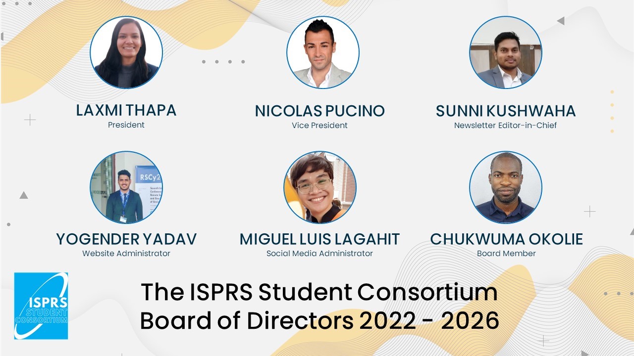
ISPRS Student Consortium announces new Board of Directors for the term 2022 – 2026
The current ISPRS SC Board of Directors is pleased to announce the incoming Board of Directors for the term 2022 – 2026:
Name Country Position
Laxmi Thapa
Nepal
President
Nicolas Pucino
Australia
Vice President
Sunni Kushwaha
India
Newsletter Editor-in-Chief
Miguel Luis Lagahit
Philippines
Social Media Administrator
Yogender Yadav
India
Website Administrator
Chukwuma Okolie
Nigeria
Board Member
The online elections were held from March 1-8, 2022. We have a voter turnout of 29% (147 of 500 individual members). For the official election results, please follow this link: https://vote.electionrunner.com/election/WQR0J/results
We will be transitioning the responsibilities from the current to our newly elected Board of Directors until the ISPRS Congress in June, where they will be officially inducted.
We hope that you will join us in congratulating our incoming officers! We also look forward to your continued participation in the Consortium’s activities!
Sincerely,
The ISPRS SC Board of Directors
2016 – 2022
Bids and Nominations for the 2022-2026 Inter-Congress Period
Bids for the XXV ISPRS Congress 2026
(listed in alphabetical order)
Bids for Technical Commissions 2022-2026
Commission I - Sensor Systems Chinese Society for Geodesy Photogrammetry and Cartography
Proposed President: TANG Xinming, Land Satellite Remote Sensing Application Center, Ministry of Natural Resources of the People’s Republic of China
Proposed Vice-president: Antonio Maria Garcia Tommaselli, São Paulo State University, Brazil
Proposed Secretary: ZHANG Tao, Land Satellite Remote Sensing Application Center, Ministry of Natural Resources of the People’s Republic of China
Commission II – Photogrammetry 1. Chinese Society for Geodesy Photogrammetry and Cartography
Proposed President: YANG Bisheng, Wuhan University, China
Proposed Vice-president: Hyyppä Juha, Finnish Geospatial Research Institute, Finland
Proposed Secretary: CHEN Chi, Wuhan University, China
2. American Society for Photogrammetry and Remote Sensing
Proposed President: Alper Yilmaz, The Ohio State University, USA
Proposed Vice-president: Jan Dirk Wegner, ETH Zürich, Switzerland
Proposed Secretary: Rongjun Qin, The Ohio State University, USA
Commission III - Remote Sensing 1. Indian Society of Remote Sensing
Proposed President: Prakash Chauhan, National Remote Sensing Centre, ISRO, Hyderabad
Proposed Vice-president: Sultan Kocaman, Hacettepe University, Ankara, Turkey
Proposed Secretary: Sameer Saran, Indian Institute of Remote Sensing, Indian Space Research Organisation
2. Société Française de Photogrammétrie et de Télédétection
Proposed President: Laurent Polidori, Universidade Federal do Pará, Brazil, and Centre d’Etudes Spatiales de la Biosphère, France
Proposed Vice-president: Alessandra Gomes, Instituto Nacional de Pesquisas Espaciais, Brazil
Proposed Secretary: Jean-François Faure, Institute of Research for Development, France
Commission IV - Spatial Information Systems Surveying and Spatial Sciences Institute, Australia
Proposed President: Sisi Zlatanova, University of New South Wales, Sydney, Australia
Proposed Vice-president: Maria Antonia Brovelli, Politecnico di Milano, Italy
Proposed Secretary: Hao Wu, National Geomatics Center of China, Beijing, China
Commission V - Education and Outreach Philippine Geosciences and Remote Sensing Society
Proposed President: Gay Jane Perez, Philippine Space Agency, Philippines
Proposed Vice-president: Josefino Comiso, NASA Goddard Space Flight Center, USA
Proposed Secretary: Ayin Tamondong, University of the Philippines, Diliman, Philippines
Nominations for Council Positions 2022-2026
President: Lena Halounová, Czech Republic
Vice President: Nicolas Paparoditis, France
Secretary General: Jie Jiang, China
Treasurer: Stewart Walker, USA
Past President: The position will be filled by appointment.
ISPRS announces Recipients of additional Awards to be presented at the XXIV IS-PRS Congress in Nice, June 6-11, 2022
See details
The ISPRS Council wholeheartedly congratulates all awardees to their splendid success! We also thank all nominators, jury members and everybody else who had a part in selecting the awardees. More information on ISPRS awards can be found at https://www.isprs.org/society/awards.aspx
New Fellows nominated for 2022
Due to the extended ISPRS period 2021-2022, Council decided to ask the Fellows Nomination Committee to select 2 further Fellows to be elected at the General Assembly.
Of the seven worthy candidates, Council is very pleased to congratulate Jon Mills and Sisi Zlatanova who were chosen to be elected in 2022.
GSW 2023 Egypt – The First Geospatial Week in Africa and The Middle East
The Arab Academy for Science, Technology, and Maritime Transport (AASTMT) will host the first Geospatial Week in Africa and Middle East, held under the auspices of H.E Secretary-General of the League of Arab States. The conference will be held in September 2023, at the InterContinental Cairo City stars Cairo, Egypt.
Read the welcome address here…
Korean Ordinary member, KSGPC announces new President
The Korean Ordinary member to ISPRS, Korean Society of Surveying, Geodesy, Photogrammetry, and Cartography, recently elected Byoungkil Lee as the new president of the Society.
ISPRS Council congratulates Byoungkil Lee on his new position and wishes him success in his new role. We look forward to close collaboration in the coming years under his leadership.
Call for Participation:
2022 Belt and Road International Student Competition on Digital Architectural Design
The 2022 Belt and Road International Student Competition on Digital Architectural Design is an ISPRS co-sponsored event aiming aims to promote the international communication of students, especially in the pandemic situation. It is organized and hosted by Beijing University of Civil Engineering and Architecture (BUCEA). The theme of the competition is “Railway: A New Bond Along the Silk Road”, focusing on construction and management of railways and facilities, urban renewal, architectural heritage protection, environmental monitoring, and other topics. The 3 categories of the competition will be Architectural Design, Structural Design, and Scene Modelling and Visualization.
Read more
Participants of the registration‐fee‐free design competition should be full time students. Submissions will be reviewed by an international jury and will be awarded in October. The event is jointly supported by UNESCO, ISPRS and other academic organizations.
URL: https://brauic.bucea.edu.cn/english/Events/
Submission Deadline: July 29, 2022
Award ceremony & work exhibition: October 2022
Contact Information: Ms. LI Yang
Tel: +86‐10‐68327443
E‐mail: brauic@163.com
(see also
ISPRS Calendar )
12th IAPR - Workshop on Pattern Recognition in Remote Sensing, as part of ICPR 2022
Montreal, Canada
Paper submission deadline: May 16, 2022iapr-tc7.ipb.uni-bonn.de/prrs-2022 icpr2022.com
See flyer here…
Commercial UAV Expo
Caesars Forum, Las Vegas, USA
September 6: Pre-Conference, Demos & Workshops
For more information visit www.expouav.com
or contact info@expouav.com
58th Photogrammetric Week '22
Advancement in Photogrammetry, Remote Sensing and Geoinformatics
September 13-16, 2022
Detailed information can be found in the programme website
The registration
UPINLBS 2022 REPORT
7th International Ubiquitous Positioning, Indoor Navigation and Location-Based Services (UPINLBS) Conference
Read the report here…
New publications in the ISPRS International Journal of Geo-Information
List of papers
Detecting People on the Street and the Streetscape Physical Environment from Baidu Street View Images and Their Effects on Community-Level Street Crime in a Chinese City
Spatial Patterns of the Spread of COVID-19 in Singapore and the Influencing Factors
The Use of Spatial Interpolation to Improve the Quality of Corn Silage Data in Case of Presence of Extreme or Missing Values
Quantitative Analysis of Land Subsidence and Its Effect on Vegetation in Xishan Coalfield of Shanxi Province
Monitoring Coastal Vulnerability by Using DEMs Based on UAV Spatial Data
Integrating Visualization and Interaction Tools for Enhancing Collaboration in Different Public Participation Settings
Aquaculture Site Selection of Oncorhynchus Mykiss (Rainbow Trout) in Markazi Province Using GIS-Based MCDM
RepDarkNet: A Multi-Branched Detector for Small-Target Detection in Remote Sensing Images
Road Network Generalization Method Constrained by Residential Areas
All Burglaries Are Not the Same: Predicting Near-Repeat Burglaries in Cities Using Modus Operandi
(Of) Indigenous Maps in the Amazon: For a Decolonial Cartography
DeepWindows: Windows Instance Segmentation through an Improved Mask R-CNN Using Spatial Attention and Relation Modules
Land Use/Land Cover Change and Their Driving Factors in the Yellow River Basin of Shandong Province Based on Google Earth Engine from 2000 to 2020
Exploring the Strategy Goals and Strategy Drivers of National Mapping, Cadastral, and Land Registry Authorities
Multi-Resolution Transformer Network for Building and Road Segmentation of Remote Sensing Image
Modeling Buildings in CityGML LOD1: Building Parts, Terrain Intersection Curve, and Address Features
A Cybercartographic Atlas of the Sky: Cybercartography, Interdisciplinary and Collaborative Work among the Pa Ipai Indigenous Families from Baja California, Mexico
Nonparametric Regression Analysis of Cyclist Waiting Times across Three Behavioral Typologies
Optimizing the Sampling Area across an Old-Growth Forest via UAV-Borne Laser Scanning, GNSS, and Radial Surveying
Characteristics and Influencing Factors of Spatial Differentiation of Market Service Industries in Rural Areas around Metropolises—A Case Study of Wuhan City’s New Urban Districts
Street Patrol Routing Optimization in Smart City Management Based on Genetic Algorithm: A Case in Zhengzhou, China
Modeling as a Critical Process of Knowledge: Survey of Buildings in a State of Ruin
3D Modeling of Individual Trees from LiDAR and Photogrammetric Point Clouds by Explicit Parametric Representations for Green Open Space (GOS) Management
Structure Monitoring with BIM and IoT: The Case Study of a Bridge Beam Model
Extracting Spatio-Temporal Information from Chinese Archaeological Site Text
Interactive Geological Data Visualization in an Immersive Environment
Uncertainty of Historic GLAD Forest Data in Temperate Climates and Implications for Forest Change Modelling
A Map-Based Recommendation System and House Price Prediction Model for Real Estate
GIScience and Historical Cartography for Evaluating Land Use Changes and Resulting Effects on Carbon Balance
Geography Education in a Collaborative Virtual Environment: A Qualitative Study on Geography Teachers
IAGC: Interactive Attention Graph Convolution Network for Semantic Segmentation of Point Clouds in Building Indoor Environment
An Application of Improved MODIS-Based Potential Evapotranspiration Estimates in a Humid Tropic Brantas Watershed—Implications for Agricultural Water Management
Location Optimization of VTS Radar Stations Considering Environmental Occlusion and Radar Attenuation
Modeling of Time Geographical Kernel Density Function under Network Constraints
Predicting Taxi-Calling Demands Using Multi-Feature and Residual Attention Graph Convolutional Long Short-Term Memory Networks
B-GPS: Blockchain-Based Global Positioning System for Improved Data Integrity and Reliability
Point Event Cluster Detection via the Bayesian Generalized Fused Lasso
A Lightweight Object Detection Method in Aerial Images Based on Dense Feature Fusion Path Aggregation Network
Clustering Methods Based on Stay Points and Grid Density for Hotspot Detection
Modeling and Querying Fuzzy SOLAP-Based Framework
Unmanned Aerial Vehicle Target Tracking Based on OTSCKF and Improved Coordinated Lateral Guidance Law
Geospatial Information Technologies for Mobile Collaborative Geological Mapping: The Italian CARG Project Case Study
SmartEle: Smart Electricity Dashboard for Detecting Consumption Patterns: A Case Study at a University Campus
Spatial-Temporal Diffusion Convolutional Network: A Novel Framework for Taxi Demand Forecasting
Modeling the Spatial and Temporal Spread of COVID-19 in Poland Based on a Spatial Interaction Model
Development of Big Data-Analysis Pipeline for Mobile Phone Data with Mobipack and Spatial Enhancement
Mapping of Rill Erosion of the Middle Volga (Russia) Region Using Deep Neural Network
Modelling Fire Behavior to Assess Community Exposure in Europe: Combining Open Data and Geospatial Analysis
Assessing the Spectral Information of Sentinel-1 and Sentinel-2 Satellites for Above-Ground Biomass Retrieval of a Tropical Forest
Ownership Protection on Digital Elevation Model (DEM) Using Transform-Based Watermarking
Contact-Fraud Victimization among Urban Seniors: An Analysis of Multilevel Influencing Factors
Consistency Analysis and Accuracy Assessment of Three Global Ten-Meter Land Cover Products in Rocky Desertification Region—A Case Study of Southwest China
A Fine-Grain Batching-Based Task Allocation Algorithm for Spatial Crowdsourcing
Temperature Accuracy Analysis by Land Cover According to the Angle of the Thermal Infrared Imaging Camera for Unmanned Aerial Vehicles
Crowd Anomaly Detection via Spatial Constraints and Meaningful Perturbation
Population Space–Time Patterns Analysis and Anthropic Pressure Assessment of the Insubric Lakes Using User-Generated Geodata
Fusion Scheme and Implementation Based on SRTM1, ASTER GDEM V3, and AW3D30
A Geospatial Platform for Crowdsourcing Green Space Area Management Using GIS and Deep Learning Classification
A Novel Traffic Flow Reduction Method Based on Incomplete Vehicle History Spatio-Temporal Trajectory Data
An Urban Hot/Cold Spot Detection Method Based on the Page Rank Value of Spatial Interaction Networks Constructed from Human Communication Records
New publications in the ISPRS International Journal of Geo-Information
List of papers
Predicting Terrorism in Europe with Remote Sensing, Spatial Statistics, and Machine Learning
Nominal Land Valuation with Best-Worst Method Using Geographic Information System: A Case of Atakum, Samsun
Is One-Way Multi-Station Feasible? Influence of Value and Cost on Travel Intention of Urban Agglomeration in the Guangdong–Hong Kong–Macao Greater Bay Area
The Point Cloud Semantic Segmentation Method for the Ming and Qing Dynasties’ Official-Style Architecture Roof Considering the Construction Regulations
Exploring the Relationship between the Spatial Distribution of Different Age Populations and Points of Interest (POI) in China
Intelligent Mining of Urban Ventilated Corridor Based on Digital Surface Model under the Guidance of K-Means
A Knowledge Discovery Method for Landslide Monitoring Based on K-Core Decomposition and the Louvain Algorithm
A Generalized 9-Intersection Model for Topological Relations between Regions with Holes
Daily Human Mobility: A Reproduction Model and Insights from the Energy Concept
A Novel Composite Index to Measure Environmental Benefits in Urban Land Use Optimization Problems
Accuracy Issues for Spatial Update of Digital Cadastral Maps
Utilizing Geospatial Data for Assessing Energy Security: Mapping Small Solar Home Systems Using Unmanned Aerial Vehicles and Deep Learning
Perspective Charts in a Multi-Foci Globe-Based Visualization of COVID-19 Data
A Robustness Study for the Extraction of Watertight Volumetric Models from Boundary Representation Data
Using TanDEM-X Global DEM to Map Coastal Flooding Exposure under Sea-Level Rise: Application to Guinea-Bissau
The Use of Machine Learning Algorithms in Urban Tree Species Classification
Similarity Analysis: Revealing the Regional Difference in Geomorphic Development in Areas with High and Coarse Sediment Yield of the Loess Plateau in China
Identification and Classification of Routine Locations Using Anonymized Mobile Communication Data
Moderating Effect of a Cross-Level Social Distancing Policy on the Disparity of COVID-19 Transmission in the United States
OSM Science—The Academic Study of the OpenStreetMap Project, Data, Contributors, Community, and Applications
An Occupancy Information Grid Model for Path Planning of Intelligent Robots
EU Net-Zero Policy Achievement Assessment in Selected Members through Automated Forecasting Algorithms
Method to Determine the Centroid of Non-Homogeneous Polygons Based on Suspension Theory
A Vector Data Model for Efficiently Rendering Large Vector Maps on Global 3D Terrain Surfaces
Using GIS to Understand Healthcare Access Variations in Flood Situation in Surabaya
Hydrological Web Services for Operational Flood Risk Monitoring and Forecasting at Local Scale in Niger
Revealing Dynamic Spatial Structures of Urban Mobility Networks and the Underlying Evolutionary Patterns
Digitalization and Classification of Cesare Battisti’s Atlas of 1915
Towards a Sensitive Urban Wind Representation in Virtual Reality
Virtual 3D City Models
Evaluation of Street Space Quality Using Streetscape Data: Perspective from Recreational Physical Activity of the Elderly
Incorporating Spatial Autocorrelation in Machine Learning Models Using Spatial Lag and Eigenvector Spatial Filtering Features
Precise Indoor Path Planning Based on Hybrid Model of GeoSOT and BIM
Visual Analysis of Vessel Behaviour Based on Trajectory Data: A Case Study of the Yangtze River Estuary
Automatic Classification of Photos by Tourist Attractions Using Deep Learning Model and Image Feature Vector Clustering
Urban Change Detection from Aerial Images Using Convolutional Neural Networks and Transfer Learning
An Efficient Plane-Segmentation Method for Indoor Point Clouds Based on Countability of Saliency Directions
Metric Rectification of Spherical Images
Quantification of Spatial Association between Commercial and Residential Spaces in Beijing Using Urban Big Data
A Tourist Behavior Analysis Framework Guided by Geo-Information Tupu Theory and Its Application in Dengfeng City, China
Bibliometric Analysis of OGC Specifications between 1994 and 2020 Based on Web of Science (WoS)
Fine Crop Classification Based on UAV Hyperspectral Images and Random Forest
Automatic Positioning of Street Objects Based on Self-Adaptive Constrained Line of Bearing from Street-View Images
Geospatial Web Services Discovery through Semantic Annotation of WPS
HDRLM3D: A Deep Reinforcement Learning-Based Model with Human-like Perceptron and Policy for Crowd Evacuation in 3D Environments
An Adaptive Embedding Network with Spatial Constraints for the Use of Few-Shot Learning in Endangered-Animal Detection
Assessment of Groundwater Potential Zones Using GIS and Fuzzy AHP Techniques—A Case Study of the Titel Municipality (Northern Serbia)
Editorial on Geomatic Applications to Coastal Research: Challenges and New Developments
Analyzing Air Pollutant Reduction Possibilities in the City of Zagreb
Spatiotemporal Analysis of Traffic Accidents Hotspots Based on Geospatial Techniques
Toward User-Generated Content as a Mechanism of Digital Placemaking—Place Experience Dimensions in Spatial Media
Optimization of Shelter Location Based on a Combined Static/Dynamic Two-Stage Optimization Methodology: A Case Study in the Central Urban Area of Xinyi City, China
Hybrid-TransCD: A Hybrid Transformer Remote Sensing Image Change Detection Network via Token Aggregation
A Distributed Hybrid Indexing for Continuous KNN Query Processing over Moving Objects
Structural Differences of PM2.5 Spatial Correlation Networks in Ten Metropolitan Areas of China
An Information Fusion Model between GeoSOT Grid and Global Hexagonal Equal Area Grid
Increasing Access to Cultural Heritage Objects from Multiple Museums through Semantically-Aware Maps
Quantitative Relations between Topological Similarity Degree and Map Scale Change of Contour Clusters in Multi-Scale Map Spaces
↑ Up
New publications in the ISPRS Journal of
Photogrammetry and Remote Sensing Volume 186 (April 2022)
List of papers
PolGAN: A deep-learning-based unsupervised forest height estimation based on the synergy of PolInSAR and LiDAR data
GeoRec: Geometry-enhanced semantic 3D reconstruction of RGB-D indoor scenes
Refraction and coordinate correction with the JONSWAP model for ICESat-2 bathymetry
An enhanced relation-aware global-local attention network for escaping human detection in indoor smoke scenarios
Mapping corn and soybean phenometrics at field scales over the United States Corn Belt by fusing time series of Landsat 8 and Sentinel-2 data with VIIRS data
Modelling people’s perceived scene complexity of real-world environments using street-view panoramas and open geodata
Gapless-REMA100: A gapless 100-m reference elevation model of Antarctica with voids filled by multi-source DEMs
DKDFN: Domain Knowledge-Guided deep collaborative fusion network for multimodal unitemporal remote sensing land cover classification
Cloud detection with boundary nets
Continuous space ant colony algorithm for automatic selection of orthophoto mosaic seamline network
Deformations monitoring in complicated-surface areas by adaptive distributed Scatterer InSAR combined with land cover: Taking the Jiaju landslide in Danba, China as an example
VD-LAB: A view-decoupled network with local-global aggregation bridge for airborne laser scanning point cloud classification
Airborne imaging spectroscopy for assessing land-use effect on soil quality in drylands
3D-CSTM: A 3D continuous spatio-temporal mapping method
A machine learning approach for identifying and delineating agricultural fields and their multi-temporal dynamics using three decades of Landsat data
Parameter selection of Touzi decomposition and a distribution improved autoencoder for PolSAR image classification
Direct photogrammetry with multispectral imagery for UAV-based snow depth estimation
Meta captioning: A meta learning based remote sensing image captioning framework
Hysteretic mapping and corridor semantic modeling using mobile LiDAR systems
Adjusting solar-induced fluorescence to nadir-viewing provides a better proxy for GPP
New publications in the ISPRS Journal of
Photogrammetry and Remote Sensing Volume 187 (May 2022)
List of papers
Editorial Board
Leveraging vocabulary tree for simultaneous match pair selection and guided feature matching of UAV images
Spatiotemporal distribution of labeled data can bias the validation and selection of supervised learning algorithms: A marine remote sensing example
Extracting planar roof structures from very high resolution images using graph neural networks
Water body classification from high-resolution optical remote sensing imagery: Achievements and perspectives
Remote sensing of total suspended matter concentration in lakes across China using Landsat images and Google Earth Engine
Change detection-based co-seismic landslide mapping through extended morphological profiles and ensemble strategy
A new East African satellite data validation station: Performance of the LSA-SAF all-weather land surface temperature product over a savannah biome
Downscaling land surface temperature: A framework based on geographically and temporally neural network weighted autoregressive model with spatio-temporal fused scaling factors
Deep residential representations: Using unsupervised learning to unlock elevation data for geo-demographic prediction
Weakly supervised semantic segmentation of airborne laser scanning point clouds
The effects of Landsat image acquisition date on winter wheat classification in the North China Plain
Field-level crop yield estimation with PRISMA and Sentinel-2
A training dataset for semantic segmentation of urban point cloud map for intelligent vehicles
Hybrid retrieval of crop traits from multi-temporal PRISMA hyperspectral imagery
Mapping the distribution of invasive tree species using deep one-class classification in the tropical montane landscape of Kenya
Multi-modal temporal attention models for crop mapping from satellite time series
FCCDN: Feature constraint network for VHR image change detection
Taxonomy of seasonal and diurnal clear-sky climatology of surface urban heat island dynamics across global cities
Individual tree detection and estimation of stem attributes with mobile laser scanning along boreal forest roads
Fusion of optical, radar and waveform LiDAR observations for land cover classification
Predicting annual PM2.5 in mainland China from 2014 to 2020 using multi temporal satellite product: An improved deep learning approach with spatial generalization ability
Modeling and SAR imaging of the sea surface: A review of the state-of-the-art with simulations
Implementing urban canopy height derived from a TanDEM-X-DEM: An expert survey and case study
New publications in the ISPRS Journal of
Photogrammetry and Remote Sensing Volume 188 (June 2022)
List of papers
Editorial Board
SAR image classification based on spiking neural network through spike-time dependent plasticity and gradient descent
Beyond single receptive field: A receptive field fusion-and-stratification network for airborne laser scanning point cloud classification
TimeMatch: Unsupervised cross-region adaptation by temporal shift estimation
A visual saliency-driven extraction framework of smoothly embedded entities in 3D point clouds of open terrain
Can linguistic features extracted from geo-referenced tweets help building function classification in remote sensing?
Deep transfer learning of global spectra for local soil carbon monitoring
A new snow bidirectional reflectance distribution function model in spectral regions from UV to SWIR: Model development and application to ground-based, aircraft and satellite observations
A new weakly supervised approach for ALS point cloud semantic segmentation
A coarse-to-fine weakly supervised learning method for green plastic cover segmentation using high-resolution remote sensing images
Monitoring vegetation dynamics with open earth observation tools: the case of fire-modulated savanna to forest transitions in Central Africa
Modelling soil organic carbon stock distribution across different land-uses in South Africa: A remote sensing and deep learning approach
Cloud and cloud shadow detection for optical satellite imagery: Features, algorithms, validation, and prospects
HyperNet: A deep network for hyperspectral, multispectral, and panchromatic image fusion
Cross-view SLAM solver: Global pose estimation of monocular ground-level video frames for 3D reconstruction using a reference 3D model from satellite images
HMSM-Net: Hierarchical multi-scale matching network for disparity estimation of high-resolution satellite stereo images
Point cloud registration and localization based on voxel plane features
Deep-learning generation of POI data with scene images
Vision based crown loss estimation for individual trees with remote aerial robots
A spectral grouping-based deep learning model for haze removal of hyperspectral images
Towards big SAR data era: An efficient Sentinel-1 Near-Real-Time InSAR processing workflow with an emphasis on co-registration and phase unwrapping
A systematic review and meta-analysis of Digital elevation model (DEM) fusion: pre-processing, methods and applications
Retraction notice to “A novel semi-supervised method for airborne LiDAR point cloud classification” [ISPRS Journal of Photogrammetry and Remote Sensing 180 (2021) 117–129]
A new terrain matching method for estimating laser pointing and ranging systematic biases for spaceborne photon-counting laser altimeters
A robust multimodal remote sensing image registration method and system using steerable filters with first- and second-order gradients
↑ Up
New publications in the ISPRS Open Journal of Photogrammetry and Remote Sensing Volume 4 (April 2022)
List of papers
Comparison of neural networks and k-nearest neighbors methods in forest stand variable estimation using airborne laser data
Detection of anomalous vehicle trajectories using federated learning
Hybrid georeferencing of images and LiDAR data for UAV-based point cloud collection at millimetre accuracy
Geometric calibration of a hyperspectral frame camera with simultaneous determination of sensors misalignment
↑ Up
01 Mar - 30 Nov 2022 http://brauic.bucea.edu.cn/
14 Jun 2022 http://cybercarto.ntua.gr/events/agile2022/
11-14 Jul 2022 https://icag-csrs2022.org/en
21 Aug 2022 http://iapr-tc7.ipb.uni-bonn.de/prrs-2022/
23-25 Aug 2022 https://www.unb.ca/ocrc/events/reality-capture/index.html
04-17 Sep 2022 https://www.sunrisesummerschool.com
06-08 Sep 2022 http://www.expouav.com/
11-15 Sep 2022 https://www.fig.net/fig2022/
03-07 Oct 2022 http://www.acrs2022.mn/
18-20 Oct 2022 http://www.medi-ast.org/SCA22/
01-04 Nov 2022 http://www.gi4dm.net/2022/
14-17 Nov 2022 https://www.geoinfo.utm.my/geoweek/
28 Nov - 01 Dec 2022 http://www.pgrsc.org/
09-11 Dec 2022 https://wwwuat.polyu.edu.hk/lsgi/icge22/
13-15 Feb 2023 https://www.geo-week.com/
» See more
Updated Events
15-19 Oct 2022 https://geospatialconf2022.ut.ac.ir
» See more
18-Apr-2022
Tenure-Track Assistant Professor - Geomatics
18-Apr-2022
Lecturer or Teaching Assistant Professor - Geomatics
18-Apr-2022
Post-doc Position
29-Apr-2022
Funded Full-Time PhD Studentship
17-May-2022
Director, United Nations Office for Outer Space Affairs, D2
For this position, applicants from the following Member States, which are unrepresented or underrepresented in the UN Secretariat as of 31 January 2022, are strongly encouraged to apply: Afghanistan, Andorra, Angola, Antigua and Barbuda, Bahrain, Belize, Brunei Darussalam, Cabo Verde, Cambodia, China, Comoros, Cuba, Cyprus, Democratic People's Republic of Korea, Djibouti, Dominica, Equatorial Guinea, Gabon, Grenada, Guinea-Bissau, Haiti, Israel, Japan, Kiribati, Kuwait, Lao People's Democratic Republic, Lesotho, Liberia, Libya, Liechtenstein, Luxembourg, Marshall Islands, Federated States of Micronesia, Monaco, Mozambique, Namibia, Nauru, Norway, Oman, Palau, Papua New Guinea, Paraguay, Qatar, Republic of Korea, Saint Lucia, Saint Vincent and the Grenadines, Samoa, San Marino, Sao Tome and Principe, Saudi Arabia, Solomon Islands, Somalia, South Sudan, Timor-Leste, Turkmenistan, Tuvalu, United Arab Emirates, United States of America, Vanuatu, Viet Nam.
Deadline: 12-Jun-2022
» See more
click here .
Imprint