ISPRS e-Bulletin
Issue No 2 - 2023

Editorial


Derek Lichti Derek Lichti

2026 Congress Update

The XXV ISPRS Congress is still more than three years away but work has already begun and planning is underway. The Congress Organizing Committee has been formed and has met several times. Several members attended Geo Week 2023 in February in Denver, USA. Geo Week 2023 organizer Diversified Communications kindly provided ISPRS with a booth in the exhibition that allowed us to promote the Society and the Congress. As noted in an earlier e-Bulletin, Geo Week provided an opportunity to hold a signing ceremony for the contract between ISPRS and the Canadian Remote Sensing Society – Société canadienne de télédétection (CRSS-SCT), the host society for the Congress.

About Toronto

As the largest city in Canada and fourth largest in North America, Toronto is an ideal location to host the Congress. Toronto is a well-connected air transportation centre with direct flights to many destinations in Europe, Asia, Africa, South America and North America, and is well resourced in terms of accommodation, restaurants and entertainment. Travel within the city is very easy thanks to the dedicated train service between Toronto Pearson Airport and Union train station downtown, and the city’s extensive transit network of subways (metro), streetcars (tram) and buses as well as the GO train and GO bus interregional transit systems that connect the Greater Toronto Area (GTA).

Toronto is a very safe city to visit, named in 2021 as the second safest city in the world. Furthermore, it  has been recognized by BBC Radio as the most diverse city in the world. That diversity is reflected in the composition of the Congress Organizing Committee with geographical representation from across Canada (six of ten provinces) and members belonging to six nationalities. You can find diverse communities across Toronto offering their cultures through food, community activities, landscaping and architecture.

The Congress venue is the state-of-the-art Metro Toronto Convention Centre (MTCC). Located in the heart of downtown Toronto, the MTCC is the largest facility of its kind in Canada. The Congress has exclusive use of the South Building of the MTCC. Up to 250,000 sq ft/23,000 m2 of exhibition space is available. MTCC is surrounded by iconic places such as CN Tower, SkyDome, Nathan Phillips Square, Yonge-Dundas Square, St Lawrence Market, The Distillery Historic District, the Royal Ontario Museum (ROM), the Art Gallery of Ontario (AGO), Toronto Inukshuk Park and many more.

MTCC is located just a few steps away from Lake Ontario and the Harbourfront neighbourhood, a vibrant and very attractive place to spend time during the day or the evening to take advantage of the vast range of restaurants and food trucks. If you are interested in more adventure, a short ferry ride to the Toronto Islands will provide excellent photographic vistas of the city and access to walking trails and Centreville Amusement Park. If you are even more adventurous and looking for a high-adrenaline experience, visit Canada’s Wonderland north of the city. The city also offers world-class fashion in many places such the Eaton Centre or along Bloor St West from Yonge St to University Ave. Toronto features a modern and vertical urban design but its many parks and trails can make you forget you are in the city.

Toronto is located close to many other attractions such as Niagara Falls and the wine region of the Niagara Peninsula, the world’s longest freshwater beach at Wasaga Beach, the Bruce Trail, the UNESCO Niagara Escarpment Biosphere Reserve and the scenic Muskoka region.

Derek Lichti
ISPRS Congress Director
isprs-cd@isprs.org
ddlichti@ucalgary.ca

Toronto skyline

Lena Halounova Lena Halounova

President’s Message

by Lena Halounová

Dear colleagues and friends,

ISPRS is a member of several important international organisations. One of them is International Science Council (ISC).

ISC was created in 2018 as the result of a merger between the International Council for Science (ICSU) and the International Social Science Council (ISSC). The ISC members are international and national organisations - international scientific unions and associations from natural and social sciences. The humanities, and national and regional scientific organizations such as academies and research councils form the national members.

The International Science Council catalyses and convenes scientific expertise, advice and influence on issues of major concern to both science and society, through a unique global membership of natural and social sciences and humanities.”

ISC’s vision can be found in the paper Science as a Global Public Good:

The mission of the ISC is to act as the global voice of and for science. As part of that mission, the ISC:

  • Speaks for the value of all science and the need for evidence-informed understanding and decision-making
  • Stimulates and supports international scientific research and scholarship on major issues of global concern
  • Articulates scientific knowledge on such issues in the public domain
  • Promotes the continued and equal advancement of scientific rigour, creativity and relevance in all parts of the world
  • Defends the free and responsible practice of science.”

The ISC is a platform which opens a scientific door to all who are interested in the world position of science and its impact to the human society and environment.

More at https://council.science.

I hope you will find interesting pieces of information at the ISC web page, in ISC publications and during ISC webinars.

All the best from Prague.

Lena

The ISPRS Foundation (TIF) News


The ISPRS Foundation The ISPRS Foundation

The ISPRS Foundation

The ISPRS Foundation (TIF) is a non-profit entity established in 2003 and managed by a Board of Trustees. It responds to ISPRS grant needs that are identified by the ISPRS Council. Grant recipients are active participants in the ISPRS and ISPRS-sponsored events, presenting posters and oral papers, publishing in the ISPRS Archives and Annals, and joining both technical discussions and cultural exchanges. While their experiences may sometimes lead to academic and professional opportunities, they always lead to new friendships and exposure to the latest research and advancements in geospatial sciences.

The ISPRS Foundation depends on individual donations and contributions from ISPRS. Donations may be mailed directly to the TIF Finance Officer, Jeff Yates (General Manager, DAT/EM Systems International, a division of NV5 Geospatial, 2014 Merrill Field Drive, Anchorage, Alaska 99501, USA, e-mail: jyates@datem.com).


White White

Extended deadline for Travel Grants by the ISPRS Foundation for GSW 2023, September 2-7 2023

Important dates for applicants for travel grants sponsored by The ISPRS Foundation.

  • Deadline for submission of travel grant applications : June 16, 2023
  • Decision and notification of successful applicants : July 15, 2023
  • Notification of acceptance of travel grant to Operations Officer : July 30, 2023

Applications can be submitted through below link:
https://www.isprs.org/foundation/forms/Travel_Grants.aspx


White White

TIF@ISRSE-39

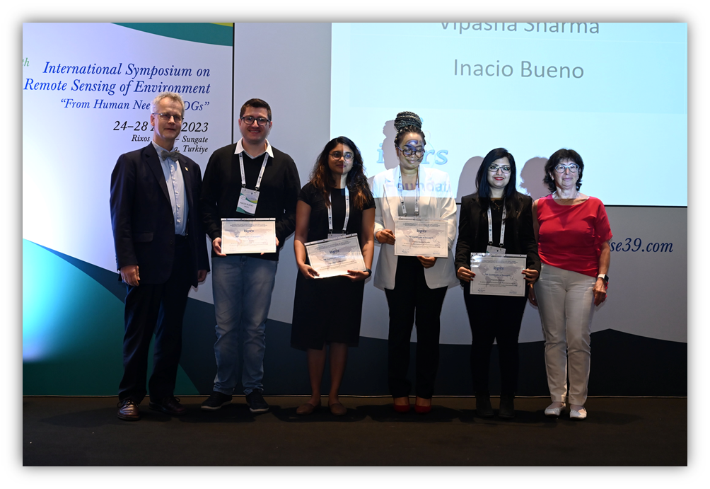
TIF provided 4 travel grants to students and young professionals from developing countries to attend the 39th International Symposium on Remote Sensing of Environment (ISRSE-39) on the theme “From Human Needs to SDGs”, held in Antalya, Turkey during April 24-28, 2023. The awardees were provided with early-bird student registration by the event organiser. The awardees were invited and awarded the grant and certificate by ISPRS President Lena Halounová and ISPRS Past President Christian Heipke in the first Plenary Session of the Symposium. The awardees have reported in their feedback on the benefits gained by attending this event with special thanks to TIF for their attending event possible.

TIF awardees

TIF awardees receiving certificates and cash awards from ISPRS Council members at ISRSE-39.

Read the reports from recipients of TIF Travel Grants for ISRSE 39 here:

  1. Madhuanand Logambal
  2. Nesisa Nyathi
  3. Vipasha Sharma

White White

TIF Grants for CIPA, Florence, Italy

TIF has announced the awardees of its travel grants to attend the Comité International de la Photogrammétrie Architecturale (CIPA) International Symposium 2023, to be held in Florence, Italy during June 25-30, 2023. It received a good response from participants who applied for the grants. Ms. Rashi Shaheen (Egypt), Ms. Tuğçe Halici (Turkey), Ms. Gusty Kartini (Indonesia) and Ms. Dina Jovanovic (Serbia) were the awardees selected by TIF’s Grants Evaluation Committee, which reviewed all the submitted applications. The awardees will receive the grant funds at the venue from one of the office-bearers of ISPRS Council. TIF congratulates the awardees and wishes them all the very best for excellent deliberations during the CIPA2023.

Student Consortium News


Student Consortium logo Student Consortium logo

New Issue of the ISPRS SC Official Newsletter – SPECTRUM is out now!

ISPRS SC has published the new issue of its Newsletter SPECTRUM (Issue No. 1, Volume 16) focusing on the theme “Application of Close Range Remote Sensing for Forestry”. In addition to the news about past and upcoming activities that the ISPRS SC has been doing and will do, the Newsletter features Dr. Antero Kukko, Director of Autonomous Mapping and Driving group, Department of Remote Sensing and Photogrammetry-Finnish geospatial Research Institute (FGI), Carlos Cabo, Research Fellow-University of Oviedo (Spain) and Sruthi M. Krishna Moorthy, Postdoctoral Researcher-Ghent University in its Important Focused Outstanding Valuable (IFOV) section. We hope their research and experiences are useful in motivating students and young professionals towards STEM related research engagement. Likewise, we have articles from Arnadi Murtiyoso, Forest Resources Management, Institute of Terrestrial Ecosystems, ETH Zurich and Arunima Singh, Faculty of Forestry and Wood Sciences, Czech University of Life Sciences, discussing about the feasibility of using laser scanning for close-range forest mapping and its usage. If you have any comments or suggestions regarding our Newsletter, feel free to write us at sc.isprs@gmail.com.


Call for Articles for the next Issue of ISPRS SC Newsletter - SPECTRUM

ISPRS SC is going to publish its second issue of the Newsletter, SPECTRUM for 2023 in July-August on the theme: “Application of Geospatial Technologies in Social Media Data Analysis”. We would like to make a call for the articles related to the theme from interested individuals. Please send your articles to sc.isprs@gmail.com by June 30, 2023. You can check our website: https://sc.isprs.org/newsletters/ for the Newsletters published so far.


White White

ISPRS SC presentation at ANU Bushfire Research Group

Nicolas Pucino (ISPRS SC-Vice President), presented the activities, values and opportunities of the ISPRS Student Consortium to the Bushfire Research Group, led by A/Prof. Marta Yebra, at the Fenner School of Environment & Society, Australian National University (Australia) on 29 April 2023. Amongst the audience, postgraduates, postdoctoral researchers and professors showed interests in our society, especially to our upcoming student chapters. One student, in particular, expressed interest in the Consortium as he is about to visit a university in Norway and would like to connect with students there.

Society News


U. V. Helava U. V. Helava

The U. V. Helava Award – Best Paper 2022 announced

The winner of the 2022 Best Paper is:

“UNetFormer: A UNet-like transformer for efficient semantic segmentation of remote sensing urban scene imagery”, by Libo Wanga, Rui Li, Ce Zhang, Shenghui Fang, Chenxi Duan, Xiaoliang Meng, and Peter M. Atkinson

published in ISPRS Journal of Photogrammetry and Remote Sensing, Volume 190, August 2022, Pages 196-214

https://doi.org/10.1016/j.isprsjprs.2022.06.008

Read the announcement here….


Jack Dangermond Jack Dangermond

Best Paper 2022 for the Jack Dangermond Award announced

The best paper 2022 for the Jack Dangermond Award has been selected by the award committee. Congratulations go to

Georganos S, Kalogirou S. for their paper A Forest of Forests: A Spatially Weighted and Computationally Efficient Formulation of Geographical Random Forests. ISPRS International Journal of Geo-Information. 2022; 11(9):471. https://doi.org/10.3390/ijgi11090471


ISPRS International Journal of Geo-Information — Open Access Journal ISPRS International Journal of Geo-Information — Open Access Journal

ISPRS International Journal of Geo-Information Special Issues

ISPRS International Journal of Geo-Information runs special issues to create collections of papers on specific topics. Submissions are open for various topics.

Please visit https://www.mdpi.com/journal/ijgi/special_issues for more information.


Wolfgang KainzWolfgang Kainz

Meet the Editors | Interview with Prof. Dr. Wolfgang Kainz — Editor-in-Chief of ISPRS International Journal of Geo-Information

Read the interview here…

General Announcements


PIESAT PIESAT

PIESAT Sat launched

On March 30, 2023, PIESAT Information Technology Co.Ltd., a Sustaining Member of ISPRS, successfully launched four remote sensing satellites into planned orbit, establishing the “Nuwa Constellation”.

The four high-resolution X-band synthetic aperture radar satellites are the first components of PIESAT's "Nuwa Constellation". The first phase of the project includes a radar remote sensing constellation composed of 28 radar satellites, and an optical remote sensing constellation composed of 10 panchromatic 0.5-meter and multi-spectral 2-meter optical satellites. After the satellite network is established, the average revisit interval of any point in the world will reach the hour level, and the full coverage of the globe will reach the month level.

The “Nuwa Constellation” service is oriented to terrain surveying and mapping, deformation monitoring and other services. It has broad business application prospects and has great advantages in urban geological disaster monitoring, ocean monitoring, flood disaster monitoring, and surface subsidence monitoring.

The satellite constellation is undergoing in-orbit testing and is expected to be officially put into operation in the near future. The data will be offered in a commercial form on the PIE-Engine platform.

NRSC CSSTEAP NRSC CSSTEAP

NRSC - CSSTEAP Remote Sensing Data Acquisition and Remote Sensing Data Processing Courses

The Indian National Remote Sensing Centre (NRSC), Indian Space Research Organisation (ISRO) is announcing two short courses: (1) Remote Sensing Data Acquisition, and (2) Remote Sensing Data Processing.  The Remote Sensing Data Acquisition and Data Processing courses are scheduled from August 21-September 1, 2023 and October 9-20, 2023, respectively, at NRSC's Earth Station Shadnagar, Hyderabad. These courses are being conducted through the Centre for Space Science and Technology Education in Asia and the Pacific (CSSTEAP).

Read more here…


UN-GGIM UN-GGIM

UN GGIM Academic Network Survey on Artificial Intelligence applied to Geospatial Information (GEOAI)

UN-GGIM Academic Network has decided to delve into the topic of artificial intelligence applied to geospatial information (GEOAI) and how we, as educators, should prepare the new generations to tackle these new technologies. 

GEOAI refers to applying artificial intelligence (AI) methods, such as deep learning and machine learning, to process and analyze geospatial data. This allows us to better understand the physical world and our interactions with it at different levels, from individual to global. AI can extract insights and patterns from geospatial data that traditional techniques may not be able to find. We believe that this topic is relevant and timely and that we must be well-prepared to face it. Although the importance of integrating geospatial information and artificial intelligence is widely recognized, there is currently no shared syllabus or body of knowledge within the geospatial sector. Geospatial AI and data science solutions often use ideas and models from multiple disciplines. While one can’t be an expert in all relevant areas, a foundational understanding of different perspectives is really valuable for geospatial AI practitioners. Therefore, defining a syllabus is urgently needed to provide structure, clarify expectations, and help with planning courses related to geospatial AI. A syllabus also helps to highlight the importance of geospatial AI and the relevance of geospatial data in this emerging field. 

On the other hand, providing a body of knowledge in geospatial AI is crucial to establish a common language and understanding of key concepts, principles, and techniques. This promotes effective communication and collaboration among researchers, practitioners, and stakeholders in this field. It also promotes best practices in the collection, analysis, and interpretation of geospatial data and their integration with AI techniques. The curriculum should be an integrative framework to prepare the next generation of students and GeoAI professionals to tackle complex challenges that can only be solved with a holistic and interdisciplinary approach like GeoAI. Such a body of knowledge would enable further innovation and creativity in the development of new techniques, tools, and applications, leading to more breakthroughs in this field. Most importantly, it supports education and training programs by providing a framework for curriculum development and assessment. Finally, a body of knowledge facilitates decision-making in policy, planning, and management, allowing decision-makers to use geospatial data and AI techniques to address complex social, economic, and environmental challenges in a more effective and efficient manner. 

As a first step, we have decided to conduct a survey to explore the current state of teaching in this field. We kindly ask for your contribution by responding to this simple and quick survey and helping us circulate it among colleagues from other universities with whom you are in contact.  

The survey requires only a few minutes and you can find it here: 

https://docs.google.com/forms/d/e/1FAIpQLSdmezBRVQ4_ sAK4SvIAB6FQrUchPh3uASLwou4wcmpoV6QXHA/viewform  

For those who have no access to the Google form, you can find the pdf of the survey here. Once complete, please send it to maria.brovelli@polimi.it with the subject: UN GGIM AN Survey

The UN-GGIM Academic Network (UN GGIM AN) is a coalition of recognized universities and research and education centers involved in research, development and education on geospatial, land information and related matters, run on a volunteer basis. 

The Network’s primary objective is to support the aims and objectives of the Committee of Experts on Global Geospatial Information Management (UN-GGIM) by facilitating access globally to research and education capabilities for UN-GGIM and its affiliated members to identify and respond to challenges and opportunities for UN-GGIM and related UN offices.


More info: UN-GGIM Academic Network – Support global geospatial management with science and research 


AUSTRALASIA AUSTRALASIA

Asia Pacific Regional Workshop on Equity in Open Access

1 June 2023
11am - 2pm AEST

For details, read here…

Announcements of Scientific Meetings                (see also ISPRS Calendar)


ISPRS ISPRS

Save The Date – TC II Midterm Symposium
Photogrammetry at the age of AI / AR

https://u.osu.edu/tc2symposium

Venue: Flamingo Hotel, Las Vegas, Nevada, USA

Dates: 

10 June 2024 - Tutorials
11-14 June 2014 Main Conference


Event Reports


UAV-g UAV-g

Unmanned Aerial Vehicles in Geomatics 2023

19-21 April 2023
Jeju, South Korea

Read the report here…


SBB-23 SBB-23

Report on 5th ISPRS International Workshop “Photogrammetric and computer vision techniques for environmental and infraStructure monitoring, Biometrics and Biomedicine”

24-26 April 2023
Moscow, Russia

Read the report here…

ISPRS International Journal of Geo-Information — Open Access Journal


ISPRS International Journal of Geo-Information — Open Access Journal ISPRS International Journal of Geo-Information — Open Access Journal

New publications
Volume 12, Issue 3 (March 2023)

Classification of Spatial Objects with the Use of Graph Neural Networks
Kaczmarek, Iwona, Iwaniak, Adam, Świetlicka, Aleksandra
No: 83

A Self-Error-Correction-Based Reversible Watermarking Scheme for Vector Maps
Qiu, Yinguo, Sun, Jiuyun, Zheng, Jiaojue
No: 84

Identifying Hazardous Crash Locations Using Empirical Bayes and Spatial Autocorrelation
Mekonnen, Anteneh Afework, Sipos, Tibor, Krizsik, Nóra
No: 85

Coastal Flooding Hazard, Exposure, and Readiness of Buildings in Hong Kong in 2080–2100, and the Implications for Real Estate Management
Singh, Minerva, Cai, Xin
No: 86

Geostatistics on Real-Time Geodata Streams—An Extended Spatiotemporal Moran’s I Index with Distributed Stream Processing Technologies
Lemmerz, Thomas, Herlé, Stefan, Blankenbach, Jörg
No: 87

Using Large-Scale Truck Trajectory Data to Explore the Location of Sustainable Urban Logistics Centres—The Case of Wuhan
Jiao, Hongzan, Yang, Faxing, Xu, Shasha, Huang, Shibiao
No: 88

HexTile: A Hexagonal DGGS-Based Map Tile Algorithm for Visualizing Big Remote Sensing Data in Spark
Yao, Xiaochuang, Yu, Guojiang, Li, Guoqing, Yan, Shuai, Zhao, Long, Zhu, Dehai
No: 89

Point Cloud Data Processing Optimization in Spectral and Spatial Dimensions Based on Multispectral Lidar for Urban Single-Wood Extraction
Shi, Shuo, Tang, Xingtao, Chen, Bowen, Chen, Biwu, Xu, Qian, Bi, Sifu, Gong, Wei
No: 90

Spatiotemporal Optimization for the Placement of Automated External Defibrillators Using Mobile Phone Data
Zhang, Jielu, Mu, Lan, Zhang, Donglan, Rajbhandari-Thapa, Janani, Chen, Zhuo, Pagán, José A., Li, Yan, Son, Heejung, Liu, Junxiu
No: 91

Two Decades of Land-Use Dynamics in an Urbanizing Tropical Watershed: Understanding the Patterns and Drivers
Wiwoho, Bagus Setiabudi, Phinn, Stuart, McIntyre, Neil
No: 92

Learning from Accidents: Spatial Intelligence Applied to Road Accidents with Insights from a Case Study in Setúbal District, Portugal
Nogueira, Pedro, Silva, Marcelo, Infante, Paulo, Nogueira, Vitor, Manuel, Paulo, Afonso, Anabela, Jacinto, Gonçalo, Rego, Leonor, Quaresma, Paulo, Saias, José, Santos, Daniel, Gois, Patricia
No: 93

Analysing River Systems with Time Series Data Using Path Queries in Graph Databases
Bollen, Erik, Hendrix, Rik, Kuijpers, Bart, Soliani, Valeria, Vaisman, Alejandro
No: 94

The Think-Aloud Method for Evaluating the Usability of a Regional Atlas
Vanicek, Tomas, Popelka, Stanislav
No: 95

Detecting Urban Commercial Districts by Fusing Points of Interest and Population Heat Data with Region-Growing Algorithms
Zhao, Bingbing, He, Xiao, Liu, Baoju, Tang, Jianbo, Deng, Min, Liu, Huimin
No: 96

Progressive Geological Modeling and Uncertainty Analysis Using Machine Learning
Li, Hong, Wan, Bo, Chu, Deping, Wang, Run, Ma, Guoxi, Fu, Jinming, Xiao, Zhuocheng
No: 97

A Novel Approach for Spatially Controllable High-Frequency Forecasts of Park Visitation Integrating Attention-Based Deep Learning Methods and Location-Based Services
Lu, Ming, Xie, Qian
No: 98

Validation of Recent DSM/DEM/DBMs in Test Areas in Greece Using Spirit Leveling, GNSS, Gravity and Echo Sounding Measurements
Grigoriadis, Vassilios N., Andritsanos, Vassilios D., Natsiopoulos, Dimitrios A.
No: 99

Graph Neural Network for Traffic Forecasting: The Research Progress
Jiang, Weiwei, Luo, Jiayun, He, Miao, Gu, Weixi
No: 100

Developing a Model to Express Spatial Relationships on Omnidirectional Images for Indoor Space Representation to Provide Location-Based Services
Claridades, Alexis Richard C., Kim, Misun, Lee, Jiyeong
No: 101

Residents’ Experiential Knowledge and Its Importance for Decision-Making Processes in Spatial Planning: A PPGIS Based Study
Bąkowska-Waldmann, Edyta
No: 102

An Automatic Derivation Method for Creation of Complex Map Symbols in a Topographic Map
Yang, Jiannan, Yin, Yong, Fang, Dengmao, Zheng, Fengjiao
No: 103

Exploring Historical Australian Expeditions with Time-Layered Cultural Maps
Yu, Feiyan, Champion, Erik, McMeekin, David
No: 104

Assessment of a Dynamic Physically Based Slope Stability Model to Evaluate Timing and Distribution of Rainfall-Induced Shallow Landslides
Thomas, Juby, Gupta, Manika, Srivastava, Prashant K., Petropoulos, George P.
No: 105

Model and Data Integrated Transfer Learning for Unstructured Map Text Detection
Zhai, Yanrui, Zhou, Xiran, Li, Honghao
No: 106

Estimating Daily NO2 Ground Level Concentrations Using Sentinel-5P and Ground Sensor Meteorological Measurements
Cedeno Jimenez, Jesus Rodrigo, Pugliese Viloria, Angelly de Jesus, Brovelli, Maria Antonia
No: 107

Method for Applying Crowdsourced Street-Level Imagery Data to Evaluate Street-Level Greenness
Zheng, Xinrui, Amemiya, Mamoru
No: 108

Spatial Non-Stationarity of Influencing Factors of China’s County Economic Development Base on a Multiscale Geographically Weighted Regression Model
Huang, Ziwei, Li, Shaoying, Peng, Yihuan, Gao, Feng
No: 109

Skyline-Based Sorting Approach for Rail Transit Stations Visualization
Cai, Zhi, Liu, Fangzhe, Qi, Qiong, Su, Xing, Guo, Limin, Ding, Zhiming
No: 110

Analysis of the Spatial Distribution and Associated Factors of the Transmission Locations of COVID-19 in the First Four Waves in Hong Kong
Yang, Daping, Shi, Wenzhong, Yu, Yue, Chen, Liang, Chen, Ruizhi
No: 111

GeoGraphVis: A Knowledge Graph and Geovisualization Empowered Cyberinfrastructure to Support Disaster Response and Humanitarian Aid
Li, Wenwen, Wang, Sizhe, Chen, Xiao, Tian, Yuanyuan, Gu, Zhining, Lopez-Carr, Anna, Schroeder, Andrew, Currier, Kitty, Schildhauer, Mark, Zhu, Rui
No: 112

HGST: A Hilbert-GeoSOT Spatio-Temporal Meshing and Coding Method for Efficient Spatio-Temporal Range Query on Massive Trajectory Data
Liu, Hong, Yan, Jining, Wang, Jinlin, Chen, Bo, Chen, Meng, Huang, Xiaohui
No: 113

Correction: Li et al. How Has the Recent Climate Change Affected the Spatiotemporal Variation of Reference Evapotranspiration in a Climate Transitional Zone of Eastern China? ISPRS Int. J. Geo-Inf. 2022, 11, 300
Li, Meng, Chu, Ronghao, Sha, Xiuzhu, Islam, Abu Reza Md. Towfiqul, Jiang, Yuelin, Shen, Shuanghe
No: 114

Analysis and Visualization of Vessels’ RElative MOtion (REMO)
Ban, Hyowon, Kim, Hye-jin
No: 115

Increasing Efficiency of Nautical Chart Production and Accessibility to Marine Environment Data through an Open-Science Compilation Workflow
Kastrisios, Christos, Dyer, Noel, Nada, Tamer, Contarinis, Stilianos, Cordero, Jose
No: 116

Efficient Trajectory Clustering with Road Network Constraints Based on Spatiotemporal Buffering
Hussain, Syed Adil, Hassan, Muhammad Umair, Nasar, Wajeeha, Ghorashi, Sara, Jamjoom, Mona M., Abdel-Aty, Abdel-Haleem, Parveen, Amna, Hameed, Ibrahim A.
No: 117

Provenance in GIServices: A Semantic Web Approach
Wu, Zhaoyan, Li, Hao, Yue, Peng
No: 118

Does Time Smoothen Space? Implications for Space-Time Representation
Sang, Neil
No: 119

Spatial Pattern Evolution and Influencing Factors of Tourism Flow in the Chengdu–Chongqing Economic Circle in China
Chen, Xuejun, Huang, Yang, Chen, Yuesheng
No: 121

Filling in the Spaces: Compactifying Cities towards Accessibility and Active Transport
Monteiro, João, Para, Marvin, Sousa, Nuno, Natividade-Jesus, Eduardo, Ostorero, Carlo, Coutinho-Rodrigues, João
No: 120

Digitization, Visualization and Accessibility of Globe Virtual Collection: Case Study Jüttner’s Globe
Štefanová, Eva, Novotná, Eva, Čábelka, Miroslav
No: 122

Generating Gridded Gross Domestic Product Data for China Using Geographically Weighted Ensemble Learning
Xu, Zekun, Wang, Yu, Sun, Guihou, Chen, Yuehong, Ma, Qiang, Zhang, Xiaoxiang
No: 123

Remote Sensing-Based Yield Estimation of Winter Wheat Using Vegetation and Soil Indices in Jalilabad, Azerbaijan
Karimli, Nilufar, Selbesoğlu, Mahmut Oğuz
No: 124

Dynamic Fusion Technology of Mobile Video and 3D GIS: The Example of Smartphone Video
Zhu, Ge, Zhang, Huili, Jiang, Yirui, Lei, Juan, He, Linqing, Li, Hongwei
No: 125

An AR Map Virtual–Real Fusion Method Based on Element Recognition
Wang, Zhangang
No: 126

Dynamic Weighted Road Network Based Multi-Vehicles Navigation and Evacuation
Cai, Zhi, Wang, Tao, Mi, Qing, Su, Xing, Guo, Limin, Ding, Zhiming
No: 127

Leveraging Deep Convolutional Neural Network for Point Symbol Recognition in Scanned Topographic Maps
Huang, Wenjun, Sun, Qun, Yu, Anzhu, Guo, Wenyue, Xu, Qing, Wen, Bowei, Xu, Li
No: 128

Flood Monitoring in the Middle and Lower Basin of the Yangtze River Using Google Earth Engine and Machine Learning Methods
Wang, Jingming, Wang, Futao, Wang, Shixin, Zhou, Yi, Ji, Jianwan, Wang, Zhenqing, Zhao, Qing, Liu, Longfei
No: 129

Measuring Traffic Congestion with Novel Metrics: A Case Study of Six U.S. Metropolitan Areas
Seong, Jeong, Kim, Yunsik, Goh, Hyewon, Kim, Hyunmin, Stanescu, Ana
No: 130

Analysis of Spatial-Temporal Evolution Pattern and Its Influencing Factors of Warehouse Supermarkets in Liaoning Province
Huang, Hao, Li, Di, Han, Zenglin, Zhang, Hao, Wang, Hongye, Duan, Ye
No: 131

A Novel Lane Line Detection Algorithm for Driverless Geographic Information Perception Using Mixed-Attention Mechanism ResNet and Row Anchor Classification
Song, Yongchao, Huang, Tao, Fu, Xin, Jiang, Yahong, Xu, Jindong, Zhao, Jindong, Yan, Weiqing, Wang, Xuan
No: 132

Dynamic Visualization of VR Map Navigation Systems Supporting Gesture Interaction
Xiao, Weiye, Lv, Xiaolei, Xue, Chengqi
No: 133

Measuring and Mapping Physical Activity Disparity (PAD) Index Based on Physical Activity Environment for Children
Yang, Jue, Mu, Lan, Rajbhandari-Thapa, Janani
No: 134

Research on Urban Fire Station Layout Planning Based on a Combined Model Method
Yu, Zhijin, Xu, Lan, Chen, Shuangshuang, Jin, Ce
No: 135


Volume 12, Issue 4 (April 2023)

Spatial Analysis of the Suitability of Hass Avocado Cultivation in the Cauca Department, Colombia, Using Multi-Criteria Decision Analysis and Geographic Information Systems
Anacona Mopan, Yesid Ediver, Solis Pino, Andrés Felipe, Rubiano-Ovalle, Oscar, Paz, Helmer, Ramirez Mejia, Isabel
No: 136

Using a Flexible Model to Compare the Efficacy of Geographical and Temporal Contextual Information of Location-Based Social Network Data for Location Prediction
Ghanaati, Fatemeh, Ekbatanifard, Gholamhossein, Khoshhal Roudposhti, Kamrad
No: 137

Tourism De-Metropolisation but Not De-Concentration: COVID-19 and World Destinations
Adamiak, Czesław
No: 139

Private Vehicles Greenhouse Gas Emission Estimation at Street Level for Berlin Based on Open Data
Ulrich, Veit, Brückner, Josephine, Schultz, Michael, Vardag, Sanam Noreen, Ludwig, Christina, Fürle, Johannes, Zia, Mohammed, Lautenbach, Sven, Zipf, Alexander
No: 138

An Optimised Region-Growing Algorithm for Extraction of the Loess Shoulder-Line from DEMs
Liu, Zihan, Zhang, Hongming, Dong, Liang, Sun, Zhitong, Wu, Shufang, Zhang, Biao, Yuan, Linlin, Wang, Zhenfei, Jia, Qimeng
No: 140

Analysis of the Spatiotemporal Urban Expansion of the Rome Coastline through GEE and RF Algorithm, Using Landsat Imagery
Lodato, Francesco, Colonna, Nicola, Pennazza, Giorgio, Praticò, Salvatore, Santonico, Marco, Vollero, Luca, Pollino, Maurizio
No: 141

A Comparison of Machine Learning Models for Mapping Tree Species Using WorldView-2 Imagery in the Agroforestry Landscape of West Africa
Usman, Muhammad, Ejaz, Mahnoor, Nichol, Janet E., Farid, Muhammad Shahid, Abbas, Sawaid, Khan, Muhammad Hassan
No: 142

Assessing Completeness of OpenStreetMap Building Footprints Using MapSwipe
Ullah, Tahira, Lautenbach, Sven, Herfort, Benjamin, Reinmuth, Marcel, Schorlemmer, Danijel
No: 143

Analysis and Forecast of Traffic Flow between Urban Functional Areas Based on Ride-Hailing Trajectories
Liao, Zhuhua, Huang, Haokai, Zhao, Yijiang, Liu, Yizhi, Zhang, Guoqiang
No: 144

A Spatio-Temporal Dynamic Visualization Method of Time-Varying Wind Fields Based on Particle System
Chu, Lele, Ai, Bo, Wen, Yubo, Shi, Qingtong, Ma, Huadong, Feng, Wenjun
No: 146

An Automated Mapping Method of 3D Geological Cross-Sections Using 2D Geological Cross-Sections and a DEM
Shang, Hao, Shen, Yan-Gen, Li, Shuang, Li, An-Bo, Zhang, Tao
No: 147

Context-Aware Point-of-Interest Recommendation Based on Similar User Clustering and Tensor Factorization
Zhou, Yan, Zhou, Kaixuan, Chen, Shuaixian
No: 145

A Management Method of Multi-Granularity Dimensions for Spatiotemporal Data
Cao, Wen, Liu, Wenhao, Tong, Xiaochong, Wang, Jianfei, Peng, Feilin, Tian, Yuzhen, Zhu, Jingwen
No: 148

Mapping Imprecision: How to Geocode Data from Inaccurate Historic Maps
Panecki, Tomasz
No: 149

Joint Deep Learning and Information Propagation for Fast 3D City Modeling
Dong, Yang, Song, Jiaxuan, Fan, Dazhao, Ji, Song, Lei, Rong
No: 150

Land Cover Impacts on Surface Temperatures: Evaluation and Application of a Novel Spatiotemporal Weighted Regression Approach
Fan, Chao, Que, Xiang, Wang, Zhe, Ma, Xiaogang
No: 151

Location Scheme of Routine Nucleic Acid Testing Sites Based on Location-Allocation Models: A Case Study of Shenzhen City
Wang, Siwaner, Sun, Qian, Chen, Pengfei, Qiu, Hui, Chen, Yang
No: 152

A Spherical Volume-Rendering Method of Ocean Scalar Data Based on Adaptive Ray Casting
Li, Weijie, Liang, Changxia, Yang, Fan, Ai, Bo, Shi, Qingtong, Lv, Guannan
No: 153

Identify Important Cities in the Belt and Road Comprehensive Traffic Network
Xie, Fengjie, Wang, Xiao, Ren, Cuiping
No: 154

Impact of Environmental Exposure on Chronic Diseases in China and Assessment of Population Health Vulnerability
Huang, Zhibin, Cao, Chunxiang, Xu, Min, Yang, Xinwei
No: 155

Evaluation of Supply–Demand Matching of Public Health Resources Based on Ga2SFCA: A Case Study of the Central Urban Area of Tianjin
Guo, Xiaoyu, Zeng, Suiping, Namaiti, Aihemaiti, Zeng, Jian
No: 156

Walk Score from 2D to 3D—Walkability for the Elderly in Two Medium-Sized Cities in Germany
Schaffert, Markus, Geist, Konstantin, Albrecht, Jonathan, Enners, Dorothea, Müller, Hartmut
No: 157

A Tale of Two Cities: COVID-19 Vaccine Hesitancy as a Result of Racial, Socioeconomic, Digital, and Partisan Divides
Li, Rui, Erickson, Daniel, Belcaid, Mareyam, Chinedu, Madu Franklin, Akanbi, Oluwabukola Olufunke
No: 158

SAM-GAN: Supervised Learning-Based Aerial Image-to-Map Translation via Generative Adversarial Networks
Xu, Jian, Zhou, Xiaowen, Han, Chaolin, Dong, Bing, Li, Hongwei
No: 159

Evacuation Simulation Implemented by ABM-BIM of Unity in Students’ Dormitory Based on Delay Time
Huang, Yonghua, Guo, Zhongyang, Chu, Hao, Sengupta, Raja
No: 160

Spatiotemporal Evolution Analysis of the Chinese Railway Network Structure Based on Self-Organizing Maps
Yin, Lingzhi, Wang, Yafei
No: 161

Modelling & Analysis of High Impact Terrorist Attacks in India & Its Neighbors
Singh, Prabal Pratap, Philip, Deepu
No: 162

Driving Factors and Scale Effects of Residents’ Willingness to Pay for Environmental Protection under the Impact of COVID-19
Zhao, Hongkun, Yang, Yaofeng, Chen, Yajuan, Yu, Huyang, Chen, Zhuo, Yang, Zhenwei
No: 163

Visual Perception of Property Rights in 3D
Grzelka, Kornelia, Bieda, Agnieszka, Bydłosz, Jarosław, Kondak, Anna
No: 164

Assessment of Ecosystem Service Value in Response to LULC Changes Using Geospatial Techniques: A Case Study in the Merbil Wetland of the Brahmaputra Valley, Assam, India
Lahon, Durlov, Sahariah, Dhrubajyoti, Debnath, Jatan, Nath, Nityaranjan, Meraj, Gowhar, Kumar, Pankaj, Hashimoto, Shizuka, Farooq, Majid
No: 165

Identification and Spatiotemporal Analysis of Bikesharing-Metro Integration Cycling
Wu, Hao, Wang, Yanhui, Sun, Yuqing, Yin, Duoduo, Li, Zhanxing, Luo, Xiaoyue
No: 166

A Semi-Automatic Semantic-Model-Based Comparison Workflow for Archaeological Features on Roman Ceramics
Thiery, Florian, Veller, Jonas, Raddatz, Laura, Rokohl, Louise, Boochs, Frank, Mees, Allard W.
No: 167

Quality Assessment of Global Ocean Island Datasets
Chen, Yijun, Zhao, Shenxin, Zhang, Lihua, Zhou, Qi
No: 168

Image Retrieval Method Based on Visual Map Pre-Sampling Construction in Indoor Positioning
Bai, Jianan, Qin, Danyang, Zheng, Ping, Ma, Lin
No: 169

Monitoring the Impacts of Human Activities on Urban Ecosystems Based on the Enhanced UCCLN (EUCCLN) Model
Abbaszadeh Tehrani, Nadia, Farhanj, Farinaz, Janalipour, Milad
No: 170

SLBRIN: A Spatial Learned Index Based on BRIN
Wang, Lijun, Hu, Linshu, Fu, Chenhua, Yu, Yuhan, Tang, Peng, Zhang, Feng, Liu, Renyi
No: 171

Efficient Algorithm for Constructing Order K Voronoi Diagrams in Road Networks
Chen, Bi Yu, Huang, Huihuang, Chen, Hui-Ping, Liu, Wenxuan, Chen, Xuan-Yan, Jia, Tao
No: 172

Investigating Geomorphic Change Using a Structure from Motion Elevation Model Created from Historical Aerial Imagery: A Case Study in Northern Lake Michigan, USA
DeWitt, Jessica D., Ashland, Francis X.
No: 173

Development Process, Quantitative Models, and Future Directions in Driving Analysis of Urban Expansion
Guan, Xuefeng, Li, Jingbo, Yang, Changlan, Xing, Weiran
No: 174

The Unseen—An Investigative Analysis of Thematic and Spatial Coverage of News on the Ongoing Refugee Crisis in West Africa
Senaratne, Hansi, Mühlbauer, Martin, Kiefl, Ralph, Cárdenas, Andrea, Prathapan, Lallu, Riedlinger, Torsten, Biewer, Carolin, Taubenböck, Hannes
No: 175

Interaction of Crime Risk across Crime Types in Hotspot Areas
Zhang, Hong, Gao, Yongping, Yao, Dizhao, Zhang, Jie
No: 176

Micro Transit Simulation of On-Demand Shuttles Based on Transit Data for First- and Last-Mile Connection
Poliziani, Cristian, Hsueh, Gary, Czerwinski, David, Wenzel, Tom, Needell, Zachary, Laarabi, Haitam, Schweizer, Joerg, Rupi, Federico
No: 177

Predicting Earthquake-Induced Landslides by Using a Stochastic Modeling Approach: A Case Study of the 2001 El Salvador Coseismic Landslides
Mercurio, Claudio, Calderón-Cucunuba, Laura Paola, Argueta-Platero, Abel Alexei, Azzara, Grazia, Cappadonia, Chiara, Martinello, Chiara, Rotigliano, Edoardo, Conoscenti, Christian
No: 178

Querying Similar Multi-Dimensional Time Series with a Spatial Database
Liu, Zheren, Kang, Chaogui, Xing, Xiaoyue
No: 179


ISPRS Journal of Photogrammetry and Remote Sensing


ISPRS Journal ISPRS Journal

New publications
Volume 198 (April 2023)

Editorial Board
Pages: ii

Knowledge and topology: A two layer spatially dependent graph neural networks to identify urban functions with time-series street view image
Yan Zhang, Pengyuan Liu, Filip Biljecki
Pages: 153-168

Developing an intelligent cloud attention network to support global urban green spaces mapping
Yang Chen, Qihao Weng, Luliang Tang, Lei Wang, Hanfa Xing, Qinhuo Liu
Pages: 197-209

Evaluation of surface reflectance bandpass adjustment techniques
Martin Claverie
Pages: 210-222

Nationwide urban tree canopy mapping and coverage assessment in Brazil from high-resolution remote sensing images using deep learning
Jianhua Guo, Qingsong Xu, Yue Zeng, Zhiheng Liu, Xiao Xiang Zhu
Pages: 1-15

Accurate estimates of land surface energy fluxes and irrigation requirements from UAV-based thermal and multispectral sensors
Junxiang Peng, Hector Nieto, Mathias {Neumann Andersen}, Kirsten Kørup, Rene Larsen, Julien Morel, David Parsons, Zhenjiang Zhou, Kiril Manevski
Pages: 238-254

High temporal frequency vehicle counting from low-resolution satellite images
Liang Liao, Jing Xiao, Yan Yang, Xujie Ma, Zheng Wang, Shin’ichi Satoh
Pages: 45-59

An exploration, analysis, and correction of the distance effect on terrestrial hyperspectral LiDAR data
Jie Bai, Zheng Niu, Shuai Gao, Kaiyi Bi, Ji Wang, Yanru Huang, Gang Sun
Pages: 60-83

ENRICH: Multi-purposE dataset for beNchmaRking In Computer vision and pHotogrammetry
Davide Marelli, Luca Morelli, Elisa Mariarosaria Farella, Simone Bianco, Gianluigi Ciocca, Fabio Remondino
Pages: 84-98

Fourier domain structural relationship analysis for unsupervised multimodal change detection
Hongruixuan Chen, Naoto Yokoya, Marco Chini
Pages: 99-114

Reconstructing cloud-contaminated NDVI images with SAR-Optical fusion using spatio-temporal partitioning and multiple linear regression
Yongjing Mao, Thomas G. {Van Niel}, Tim R. McVicar
Pages: 115-139

HiSup: Accurate polygonal mapping of buildings in satellite imagery with hierarchical supervision
Bowen Xu, Jiakun Xu, Nan Xue, Gui-Song Xia
Pages: 284-296

SemiRoadExNet: A semi-supervised network for road extraction from remote sensing imagery via adversarial learning
Hao Chen, Zhenghong Li, Jiangjiang Wu, Wei Xiong, Chun Du
Pages: 169-183

Space-to-speed architecture supporting acceleration on VHR image processing
Shenlu Jiang, Yuliya Tarabalka, Wei Yao, Zhonghua Hong, Guofu Feng
Pages: 30-44

Improvement in crop mapping from satellite image time series by effectively supervising deep neural networks
Sina Mohammadi, Mariana Belgiu, Alfred Stein
Pages: 272-283

Global–local–global context-aware network for salient object detection in optical remote sensing images
Zhen Bai, Gongyang Li, Zhi Liu
Pages: 184-196

A domain specific knowledge extraction transformer method for multisource satellite-borne SAR images ship detection
Siyuan Zhao, Ying Luo, Tao Zhang, Weiwei Guo, Zenghui Zhang
Pages: 16-29

Phase ambiguity resolution and mixed pixel detection in EDM with multiple modulation wavelengths
Jemil Avers Butt, David Salido-Monzú, Andreas Wieser
Pages: 255-271

Deep Semantic-Visual Alignment for zero-shot remote sensing image scene classification
Wenjia Xu, Jiuniu Wang, Zhiwei Wei, Mugen Peng, Yirong Wu
Pages: 140-152

A three-point solution with scale estimation ability for two-view flat-refractive underwater photogrammetry
Bashar Elnashef, Sagi Filin
Pages: 223-237

Spectral saturation in the remote sensing of high-density vegetation traits: A systematic review of progress, challenges, and prospects
Onisimo Mutanga, Anita Masenyama, Mbulisi Sibanda
Pages: 297-309


New publications
Volume 199 (April 2023)

Editorial Board
Pages: ii

Polarized laser target detection system for smoky environment based on full-waveform decomposition and multiscale convolutional neural networks with attention
Xiaobin Xu, Qinyang Qu, Haojie Zhang, Jiali Wang, Jialin Wu, Yingying Ran, Zhiying Tan
Pages: 214-225

Street-level imagery analytics and applications
Fan Zhang, Jan Dirk Wegner, Bisheng Yang, Yu Li
Pages: 195-196

Towards better exploiting object-based image analysis paradigm for local climate zones mapping
Lei Ma, Ziyun Yan, Weiqiang He, Ligang Lv, Guangjun He, Manchun Li
Pages: 73-86

Fast and deterministic (3+1)DOF point set registration with gravity prior
Xinyi Li, Yinlong Liu, Yan Xia, Venkatnarayanan Lakshminarasimhan, Hu Cao, Feihu Zhang, Uwe Stilla, Alois Knoll
Pages: 118-132

Global-aware siamese network for change detection on remote sensing images
Ruiqian Zhang, Hanchao Zhang, Xiaogang Ning, Xiao Huang, Jiaming Wang, Wei Cui
Pages: 61-72

AFLI-Calib: Robust LiDAR-IMU extrinsic self-calibration based on adaptive frame length LiDAR odometry
Weitong Wu, Jianping Li, Chi Chen, Bisheng Yang, Xianghong Zou, Yandi Yang, Yuhang Xu, Ruofei Zhong, Ruibo Chen
Pages: 157-181

Atmospheric-correction-free red tide quantification algorithm for GOCI based on machine learning combined with a radiative transfer simulation
Young Jun Kim, Wonkook Kim, Jungho Im, Jongkuk Choi, Sunju Lee
Pages: 197-213

Review of ground and aerial methods for vegetation cover fraction (fCover) and related quantities estimation: definitions, advances, challenges, and future perspectives
Linyuan Li, Xihan Mu, Hailan Jiang, Francesco Chianucci, Ronghai Hu, Wanjuan Song, Jianbo Qi, Shouyang Liu, Jiaxin Zhou, Ling Chen, Huaguo Huang, Guangjian Yan
Pages: 133-156

OGMN: Occlusion-guided multi-task network for object detection in UAV images
Xuexue Li, Wenhui Diao, Yongqiang Mao, Peng Gao, Xiuhua Mao, Xinming Li, Xian Sun
Pages: 242-257

A practical method for angular normalization of global MODIS land surface temperature over vegetated surfaces
Junrui Wang, Ronglin Tang, Yazhen Jiang, Meng Liu, Zhao-Liang Li
Pages: 289-304

The U. V. Helava Award – Best Paper Volumes 183-194 (2022)
Qihao Wen
Pages: 350-351

Learning spectral-spatial representations from VHR images for fine-scale crop type mapping: A case study of rice-crayfish field extraction in South China
Zhiwen Cai, Haodong Wei, Qiong Hu, Wei Zhou, Xinyu Zhang, Wenjie Jin, Ling Wang, Shuxia Yu, Zhen Wang, Baodong Xu, Zhihua Shi
Pages: 28-39

An unsupervised domain adaptation deep learning method for spatial and temporal transferable crop type mapping using Sentinel-2 imagery
Yumiao Wang, Luwei Feng, Zhou Zhang, Feng Tian
Pages: 102-117

Graph-based spatial pattern multi-type change detection
Lingwen Tian, Yuanyuan Meng, Lihong Zhu, Xinyu Zou, Xiangnan Liu
Pages: 258-271

GL-Net: Semantic segmentation for point clouds of shield tunnel via global feature learning and local feature discriminative aggregation
Jincheng Li, Zhenxin Zhang, Haili Sun, Si Xie, Jianjun Zou, Changqi Ji, Yue Lu, Xiaoxu Ren, Liuzhao Wang
Pages: 335-349

Instance recognition of street trees from urban point clouds using a three-stage neural network
Tengping Jiang, Yongjun Wang, Shan Liu, Qinyu Zhang, Lin Zhao, Jian Sun
Pages: 305-334

Assessing the capability of Sentinel-2 time-series to estimate soil organic carbon and clay content at local scale in croplands
Fabio Castaldi, Muhammed {Halil Koparan}, Johanna Wetterlind, Renaldas Žydelis, Ialina Vinci, Ayşe {Özge Savaş}, Cantekin Kıvrak, Tülay Tunçay, Jonas Volungevičius, Silvia Obber, Francesca Ragazzi, Douglas Malo, Emmanuelle Vaudour
Pages: 40-60

Triple Robustness Augmentation Local Features for multi-source image registration
Changwei Wang, Lele Xu, Rongtao Xu, Shibiao Xu, Weiliang Meng, Ruisheng Wang, Xiaopeng Zhang
Pages: 1-14

Spatial-spectral-temporal connective tensor network decomposition for thick cloud removal
Wen-Jie Zheng, Xi-Le Zhao, Yu-Bang Zheng, Jie Lin, Lina Zhuang, Ting-Zhu Huang
Pages: 182-194

Deforestation detection using a spatio-temporal deep learning approach with synthetic aperture radar and multispectral images
Jonathan V. Solórzano, Jean François Mas, J. Alberto Gallardo-Cruz, Yan Gao, Ana {Fernández-Montes de Oca}
Pages: 87-101

Aligning semantic distribution in fusing optical and SAR images for land use classification
Wangbin Li, Kaimin Sun, Wenzhuo Li, Jinjiang Wei, Shunxia Miao, Song Gao, Qinhui Zhou
Pages: 272-288

PolyBuilding: Polygon transformer for building extraction
Yuan Hu, Zhibin Wang, Zhou Huang, Yu Liu
Pages: 15-27


ISPRS Open Journal of Photogrammetry and Remote Sensing


ISPRS Open Journal of Photogrammetry and Remote Sensing ISPRS Open Journal of Photogrammetry and Remote Sensing

New publications
Volume 8 (April 2023)

Towards global scale segmentation with OpenStreetMap and remote sensing
Munazza Usmani, Maurizio Napolitano, Francesca Bovolo
Article: 100031

Point cloud registration for LiDAR and photogrammetric data: A critical synthesis and performance analysis on classic and deep learning algorithms
Ningli Xu, Rongjun Qin, Shuang Song
Article:100032

Precision estimation of 3D objects using an observation distribution model in support of terrestrial laser scanner network design
D.D. Lichti, T.O. Chan, Kate Pexman
Article: 100035

Towards complete tree crown delineation by instance segmentation with Mask R–CNN and DETR using UAV-based multispectral imagery and lidar data
S. Dersch, A. Schöttl, P. Krzystek, M. Heurich
Article: 100037

Spatial patterns of biomass change across Finland in 2009–2015
Markus Haakana, Sakari Tuominen, Juha Heikkinen, Mikko Peltoniemi, Aleksi Lehtonen
Article: 100036

Pixel-based mapping of open field and protected agriculture using constrained Sentinel-2 data
Daniele la Cecilia, Manu Tom, Christian Stamm, Daniel Odermatt
Article: 100033

UAV-based reference data for the prediction of fractional cover of standing deadwood from Sentinel time series
Felix Schiefer, Sebastian Schmidtlein, Annett Frick, Julian Frey, Randolf Klinke, Katarzyna Zielewska-Büttner, Samuli Junttila, Andreas Uhl, Teja Kattenborn
Article: 100034


New Events


03-05 May 2023
SPECTRA 2023
Workshop on Hyperspectral remote sensing
https://cutn.ac.in/
Central University of Tamil Nadu, Thiruvarur, India
 

17-21 Jul 2023
International Remote Sensing Summer School
https://aitonline.org/
San Vero Milis, Oristano - Italy
 

14-21 Oct 2023
Geoinformation Technologies for Cultural Heritage Documentation
International Summerschool - supported by CIPA
https://3dom.fbk.eu/summerschool2023
Istanbul, Türkiye
 

04-05 Dec 2023
The 2nd Ramon International Geospatial Intelligence 360 Conference
Geospatial Intelligence for Sustainable and Resilient Future
https://www.geoint360.com/
Tel-Aviv, Israel
 

11-12 Jan 2024
GeoAdvances 2024
8th International Conference on Geoinformation Advances
http://www.geoadvances.web.tr
Istanbul, Türkiye
 

07-09 Apr 2025
6th JISDM
6th Joint International Symposium on Deformation Monitoring
http://www.gik.kit.edu/
Karlsruhe, Germany
 

» See more

Job Opportunities

 
27-Apr-2023
Tenure track research professorship (“CPJ”) Bundling machine learning and simulation for modeling the evolution of territories
IGN-France, Université Gustave Eiffel, National School of Geoinformation (ENSG-Géomatique), Saint-Mandé, France
Deadline: 22-May-2023
 
30-Apr-2023
Postdoctoral Researcher on Digital Twins of Large Bridges
DepartmentofCivilandEnvironmentalEngineeringattheUniversityofHouston, USA
 
3-May-2023
(Senior) Postdoctoral Researcher (f/m/d) - 3D/4D Point Clouds & Machine Learning
Heidelberg University, Institute of Geography / IWR, 3D Geospatial Data Processing (3DGeo)
 
11-May-2023
PhD position on Adaptive Coastal Monitoring
The Faculty of Civil Engineering & Geosciences (CEG), Delft University of Technology, The Netherlands
Deadline: 15-Jun-2023
 

» See more

 
© ISPRS, 2023.
Imprint