ISPRS e-Bulletin
Issue No 1 - 2023

Editorial


	JIANG Jie 	JIANG Jie

Newly established Working Groups for 2022-26

by Jiang Jie

The new Working Groups (WGs) were approved by ISPRS Council based on the proposals received from each of the five Technical Commission Presidents (TCPs) elected at the XXIV ISPRS Congress, which was held in June 2022. The topics and the Terms of Reference (ToR) of the WGs have been prepared in coordination with the ISPRS Resolutions, which were approved by the General Assembly, and have been reviewed by International Science Advisory Committee of ISPRS.

As the basic work units of ISPRS, the WGs are under the direction of the respective Commissions and are responsible for the scientific work of the Society. They organise scientific activities such as workshops, research, tests, case studies, questionnaires, tutorials and publications. The activity of each WG is reviewed and evaluated by the TCP.

There is a total of 52 WGs for 2022-26, including 9 Inter-Commission WGs (ICWGs) jointly managed by more than one technical commission

  • Commission I (Sensor Systems) has 8 WGs and 1 ICWG, including (near-) real-time indoor and outdoor mapping; multi-modal sensor; onboard processing; integration of mapping and navigatiing; and small satellite systems and constellations.
  • Commission II (Photogrammetry) has 9 WGs and 2 ICWGs, including machine learning; algorithmic developments to support autonomous platforms; and integrative and generalizable artificial intelligence and machine learning.
  • Commission III (Remote Sensing) has 9 WGs and 3 ICWGs, including new methods and techniques for processing multi-dimensional remote sensing imagery; remote sensing applications; and geospatially-enabled monitoring of UN SDGs.
  • Commission IV (Spatial Information Science) has 11 WGs and 2 ICWGs, including multi-dimensional and semantically rich data models; spatial analysis and advanced visualization; and information services and applications.
  • Commission V (Education and Outreach) has 6 WGs and one ICWG focused on education, training and resource-sharing.

Each WG is led by a WG Chair, a maximum of two Co-Chairs, and a WG Secretary. Detailed information on ISPRS WGs is available at https://www2.isprs.org/commissions/.


Lena Halounova Lena Halounova

President’s Message

by Lena Halounová

Dear colleagues and friends,

I would like to inform you about ISPRS decision-making. ISPRS Council is guided by three advisory committees:

ISAC – International Science Advisory Committee has been established to support the Council and the ISPRS General Assembly in identifying and addressing important scientific and technologic (S&T) trends which impact the scope of the ISPRS Commissions and the activities which should be addressed by ISPRS Working Groups. The ISAC is to ensure that ISPRS S&T activities are in proper balance and cover the breadth of the Society's S&T mission.”

Since the Congress in Nice in June 2022, ISAC has been chaired by Charles Toth, from The Ohio University, who was ISPRS Vice President (2016-22). The committee consists of scientists from Australia, Austria, Chile, France, Germany, Hong Kong, India, Japan, Netherlands, and USA.

IPAC – International Policy Advisory Committeeis to advise the Council on issues relevant to Society interaction with intergovernmental organizations, especially those that relate to ISPRS collaborative activities with various elements of the United Nations as the UN Office for Outer Space Affairs - Committee on Peaceful Uses of Outer Space (UN OOSA COPUOS) and UN-GGIM, the International Science Council (ISC), the Committee on Earth Observation Satellites (CEOS), and other similar organisations.

For many years, IPAC has been chaired by Gunter Schreier, from DLR (German Aerospace Center). He has invited top experts from all continents to the committee which is involved in various aspects of ISPRS policy making. There are 14 members in IPAC, from Australia, Austria, Brazil, Ethiopia, France, Germany, Italy, Nigeria, South Africa, Switzerland, the Netherlands and USA.

I²AC – International Industrial Advisory Committee  “has been established to support the Council in its dealings with the geospatial industry, with the aim of making ISPRS more relevant to industry. Recognizing that ISPRS is a learned society of academics, and also is strong in governmental mapping agencies, it needs to improve its interactions with the rapidly changing and evolving Geospatial industry as the driver of all global geospatial activities and innovations.”

I²AC is chaired by Hartmut Rosengarten, recently retired from Geosystems . He has chosen twenty representatives from the geospatial industry from Austria, Canada, China, Denmark, Germany, Israel, Japan, Netherlands, Norway, Russia and Switzerland as members of the committee.

All three committees are very valuable to Council and therefore, to ISPRS as well. ISPRS is very grateful for their voluntary support.

A huge thank you to everybody from these committees for your ideas, support and great work.

The ISPRS Foundation (TIF) News


The ISPRS Foundation The ISPRS Foundation

Travel Grants by the ISPRS Foundation for CIPA, June 25-30 2023

Important dates for applicants for travel grants sponsored by The ISPRS Foundation.

  • Applications for travel grants “live” on TIF web site: February 12, 2023
  • Deadline for submission of travel grant applications: April 12, 2023
  • Decision and notification of successful applicants: April 28, 2023
  • Notification of acceptance of travel grant to Operations Officer: May 12, 2023

Applications can be submitted through below link:
https://www.isprs.org/foundation/forms/Travel_Grants.aspx


White White

TIF Travel Grants for ISRSE 39, Antalya, Turkey

The ISPRS Foundation (TIF) has announced the awardees of its Travel Grants to attend the International Symposium on Remote Sensing of Environment (ISRSE)-39, to be held at Antalya, Turkey during April 24-28, 2023. A good response was received from participants who applied for the grants. Ms. Nesisa A. Nyathi (Switzerland), Ms. Logambal Madhuanand (The Netherlands), Ms. Vipasha Sharma (India) and Dr. Inacio Bueno (Brazil) were the awardees selected by TIF’s Grants Evaluation Committee, which reviewed all the submitted applications. The awardees will receive the grant funds at the Symposium from one of the members of ISPRS Council. TIF congratulates the awardees and wishes them all the very best for excellent deliberations during the Symposium.

Student Consortium News


Student Consortium logo Student Consortium logo

Call for Youth Presentation Forum at ISPRS Geospatial Week 2023

ISPRS Student Consortium is participating in the ISPRS Geospatial Week 2023 (GSW 2023) in Cairo, Egypt on 2-7 September 2023. ISPRS SC has organized a forum where students and young researchers attending the GSW 2023 can give presentations about their research. We particularly encourage local and regional students to participate and provide the attendees with an overview of the geospatial and/or remote sensing research undertaken in Egypt and other African regions, although presentations from around the globe are welcomed.

The objective of this forum is to provide a platform for communication, networking and exchange of research ideas amongst students and young professionals, while promoting ISPRS SC and its activities. Moreover, as one of the ISPRS SC targets of 2023 is to expand our sphere of influence in Africa through Student Chapters and collaborations, this event will be an opportunity for us to connect with people and organizations which may become our next African partners.

We look forward to welcoming you in Cairo!


White White

Opportunities to work within the ISPRS Student Consortium

ISPRS SC is still looking for the volunteers to join its Proof Reading and Design Team. If you are looking for the opportunity to get engaged in ISPRS SC, this can be the opportunity for you. Do not hesitate to contact the team at sc.isprs@gmail.com.

Society News


ISPRS ISPRS

Seven Projects win ISPRS Scientific Initiatives 2023 (SI2023) Awards

The ISPRS Scientific Initiatives are defined in the ISPRS Orange Book, Appendix 9a (https://www.isprs.org/documents/orangebook/app9a.aspx). Every two years applications are invited for proposals and a total of up to CHF70,000 is awarded.

A number of strong applications was received for the SI2023s. These usually come up through the Working Groups, then the Technical Commission Presidents, who endorse them. Finally, a small panel chosen from ISPRS Council makes the final decisions.

Seven SI2023 proposals were given awards, which total around CHF58,000. The projects are funded and work has begun. The titles and principal investigators of these projects are as follows (see https://www.isprs.org/society/si/default.aspx for more detail):

  • Benchmarking of absolute and relative positioning solutions under GNSS denied environments for mobile geomatics (Yunsheng Wang & Liang Chen)
  • Publishing dataset guideline: gaps and trends in research data management in the ISPRS community (Dorota Iwaszczuk)
  • BeBaOI: Benchmark and Baseline Methods for determining Overlapping Images (Xin Wang & Yu Feng)
  • NAUTILUS uNder And throUgh waTer datasets for geospatIaL studies (Erica Nocerino)
  • Benchmarking of publicly available software solutions for close-range point cloud processing of forest ecosystems (Carlos Cabo & Xinlian Liang)
  • Geospatial data base for exposomics (Kamel Boulos)
  • Integrating IndoorGML with outdoors: Automatic routing graph generation for indoor‐outdoor transitional space for seamless navigation (Zhiyong Wang)

ISPRS congratulates these winners and wishes them every success with their projects. Funding is for one calendar year and, once the projects are complete, the resulting reports will be posted on the ISPRS website.


ISPRS ISPRS

Invitation to Submit to Special Edition Disaster Risk Reduction: In Support of the Sendai Framework and Improved Societal Well-Being

 
Read more ...


ISPRS ISPRS

New Associate Member: Eratosthenes Centre of Excellence


ISPRS warmly welcomes Eratosthenes Centre of Excellence, from Cyprus, as a new Associate Member and looks forward to fruitful collaboration in the future.

Read about our new member here, and visit eratosthenes.org.cy.


UN UN

ISPRS responses to COPUOS (UN OOSA) Questionnaires

ISPRS is an observer of COPUOS of UN OOSA. The Committee on the Peaceful Uses of Outer Space (COPUOS) was set up by the [UN] General Assembly in 1959 to govern the exploration and use of space for the benefit of all humanity: for peace, security and development. The Committee was tasked with reviewing international cooperation in peaceful uses of outer space, studying space-related activities that could be undertaken by the UN, encouraging space research programmes, and studying legal problems arising from the exploration of outer space.

The Committee has two subcommittees - the Scientific and Technical Subcommittee, and the Legal Subcommittee, both established in 1961.

COPUOS headquarters addresses its members to obtain views and knowledge about selected issues. Questionnaires were circulated seeking answers to: a set of questions provided by the Chair of the Working Group on the Status and Application of the Five United Nations Treaties on Outer Space, taking into account the UNISPACE+50 process; and on the application of international law to small-satellite activities. The ISPRS InternationalPolicy Advisory Committee, IPAC, was asked to respond. The official replies from ISPRS to the two sets of questions sent by UN OOSA Legal Subcommittee to its members were authored by Fabio Tronchetti, professor at Beihang University and the University of Mississippi, and reviewed by Frans von der Dunk, professor at the University of Nebraska-Lincoln. Both are IPAC members. The final editing was done by Gunter Schreier, IPAC Chair.

Read the ISPRS replies to the questionnaires here:


ISPRS ISPRS

ISPRS Keynote Speaker Programme

Now that in-person meetings are taking place again following the pandemic, we would like to remind members about ISPRS financial support for Keynote Speakers.

To improve the benefits ISPRS provides to its Ordinary, Associate and Regional Members, the ISPRS Keynote Speaker Programme was introduced in 2019.

The programme enables these Members to ask for support when wanting to invite keynote speakers to their scientific meetings. Expenses will be split between ISPRS, providing the travel expenses, and the organizing Member, covering the local costs.

The application form for an ISPRS Member to request a speaker within the ISPRS Keynote Speaker Programme should be submitted to the Secretary General six months prior to the event.


ISPRS ISPRS

XXV ISPRS Congress Contract signed

During the recent Council Meeting, held in Denver, Colorado, the contract for the XXV ISPRS Congress was finalised. ISPRS President, Lena Halounovà, Canadian Remote Sensing Society President, Ahmed Shaker, and Congress Director, Derek Lichti signed the contract at the ISPRS Congress booth during the Geo Week.


IJGI IJGI

IJGI 2023 Young Investigator Award

ISPRS International Journal of Geo-Information is now inviting nominations for the IJGI 2023 Young Investigator Award. This prize will be awarded to one young investigator in recognition of their excellence in the field of geo-information. All nominations will be assessed by an Award Evaluation Committee led by the Editor-in-Chief, Prof. Dr. Wolfgang Kainz.

Read details here …


ISPRS Open Journal of Photogrammetry and Remote Sensing ISPRS Open Journal of Photogrammetry and Remote Sensing

Collaboration between the ISPRS Journal and the ISPRS Open Journal

Dear ISPRS Readers, Authors, and Members,

We would like to take this opportunity to remind you of the close collaboration between the ISPRS Journal of Photogrammetry and Remote Sensing (hybrid journal) and the ISPRS Open Journal of Photogrammetry and Remote Sensing (gold Open Access journal).

Over the past years, our hybrid journal has experienced continuous success, as evidenced by the increasing number of submissions and its Impact Factor of 11.774. Given its undisputed prestige and power, this journal is proud to support its younger counterpart. The close collaboration of the two editorial teams is key to further success of the two journals.

Furthermore, we are delighted to announce that ISPRS, Elsevier, and Trimble have agreed to introduce the Ackermann award, named after Prof. Friedrich Ackermann (1929-2021). This award will be given to exceptional researchers who have published their work in the gold Open Access journal, similar to the U.V. Helava award that is given for the hybrid one. This new award will help to further promote and recognize the exceptional research that is being published in the gold Open Access journal and will also serve as testament to its growing success and influence in the field of photogrammetry and remote sensing.

We would like to emphasize the importance of submitting your high-quality research to both journals, contributing to the advancement of the field of photogrammetry and remote sensing and helping to maintain a strong community of ISPRS researchers. A limited number of waivers for APC charges are available for submissions to the Open Journal. Authors requiring support are encouraged to contact the Editor-in-Chief for details.

We look forward to seeing the outstanding research that will be published and the future recipients of the Ackermann and the U.V. Helava awards.

Thank you for your continued support and collaboration.

Sincerely,

The ISPRS Team

General Announcements


ASPRS ASPRS

Revisions to the ASPRS Positional Accuracy Standards for Geospatial Data (2014)

Seeking Public Comments! Read the document here …

The deadline for comment submission is Wednesday, March 15, 2023, at 11:59 PM EST.  


Sr WONG Kwok Leung Sr WONG Kwok Leung

Hong Kong Institute of Surveyors elects new President

The Hong Kong Institute of Surveyors recently elected its new the General Council. ISPRS congratulates Sr Wong Kwok Leung, Paul, on his new office as President, along with all other new office bearers.

Announcements of Scientific Meetings                (see also ISPRS Calendar)


ISC ISC

ISC Distinguished Lecture Series: “Basic Sciences For Sustainable Development”

In order to promote the International Year of Basic Sciences for Sustainable Development and to highlight the importance of basic sciences for the ISC community, the ISC GeoUnions have initiated the “Distinguished Lecture Series on Basic Sciences for Sustainable Development”. ISPRS is a member of GeoUnions.

Join ISC for the second online event in this series:

21 March, 14:00 UTC: “Apprehending the Duality of Disaster Risk and Sustainable Development” – Registration: https://council.science/events/duality-disaster-risk-sustainable-development/


Geo Week 2023 Geo Week 2023

CIPA Spring School

23-29 March 2023
Montecatini Terme, Italy

The 8th CIPA-HD Spring School, "3D Surveying and Modeling of Cultural Heritage," will be an opportunity for young researchers in the surveying and heritage fields to deepen their knowledge and expertise with reality-based 3D modeling techniques. More information is available on the official website: https://bit.ly/CIPA2023SpringSchool.


UAV-g UAV-g

New Space & Commercialization in EO

Partners Program hosted by ISPRS at the Geospatial World Forum (GWF), 2-5 May 2023, Rotterdam, The Netherlands
Date and Time: 4 May, 13:00-14:30

Venue: Postillion Hotel & Convention Centre WTC, Beursplein 37, Meent 110, 3011 AA Rotterdam, The Netherlands

Moderator: Gunter Schreier, DLR & Chair ISPRS IPAC

Web link: Space + Spatial Value Chain - A symposium in GWF 2023 (geospatialworldforum.org)

New Space and commercialization in EO play an important role in national and global space programs. Start-up companies deliver precise and customized missions and services, which are not covered by the large national and international programs. However, they are required by these programs to fill gaps in observation capabilities and services. Further on, New Space companies have the flexibility and vision to open new opportunities of EO and GIS applications in traditional as well as in new domains. The current growth in New Space capabilities shows the importance of these companies in the development of the entire Earth Observation domain, if not the entire space and GIS sector.

See further interesting New Space start-ups here:

PressRelease-Overall2022 - Copernicus Masters (copernicus-masters.com)


CVPR CVPR

Photogrammetric Computer Vision at CVPR2023

19 June 2023
Vancouver, Canada

This half-day workshop will provide a forum for original research in computer vision and photogrammetry and will feature renowned keynote speakers, oral presentations and a poster session. We invite submissions of high-quality research papers concerning the generation, processing, and analysis of images, 3D point clouds and surface models, with the goal of enhancing accuracy and completeness. Accepted publications will be published in the CVPR proceedings.

Important dates
Paper submission deadline:    Mar 10 ‘23 11:59 PM PST
Notification to authors:            Mar 20 ‘23 11:59 PM PST
Camera-ready deadline:         April 7 ‘23 11:59 PM PST

Workshop website: https://photogrammetric-cv-workshop.github.io/


SELPER SELPER

Joint ISPRS-SELPER Event in the Amazon in 2024

4-8 November 2024
Belém, Brazil

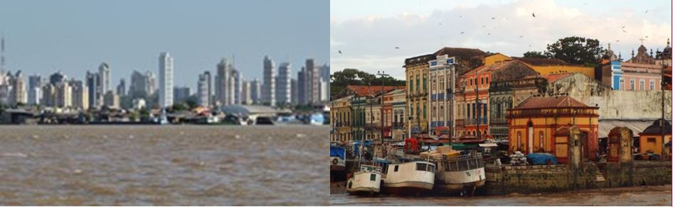
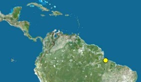
ISPRS Commission III, "Remote Sensing", jointly hosted by France and Brazil for the 2022-26 term, will hold its mid-term symposium in Belém (northern Brazil) on 4-8 November 2024. Following the election of Brazil to the rotating presidency of the Latin American remote sensing society SELPER, the next biennial SELPER symposium will be held at the same time as the mid-term symposium in Belém. It is therefore a double international event that will be held in the "city of mango trees", at the gateway of the Amazon, where, after an overview of the latest developments in remote sensing and its applications, tours will be offered to those who wish to discover the Amazonian environment. Note that Belém is a candidate to host the COP - the world's largest climate-related event - in 2025. "Belém keeps its doors open to discuss the Amazon, to discuss climate around the world and to find solutions", said Helder Barbalho, the governor of the state of Pará, of which Belém is the capital. Thus, the ISPRS-SELPER double event on remote sensing, which will take place at the end of 2024, will be more than a scientific conference: participants from all over the world will contribute to raising awareness among political stakeholders of the need to use science, and in particular Earth observation data, for the benefit of the Amazon and the planet.

Event Reports


IGSM 2022 IGSM 2022

IGSM 2022

Hannover/Hamburg
6-12 June 2022

Read the report here…


8.2. The International Conference on Geospatial Information Science: Education, Innovation and Applications 8.2. The International Conference on Geospatial Information Science: Education, Innovation and Applications

The International Conference on Geospatial Information Science: Education, Innovation and Applications

November 10-11, 2022
Wuhan University, China

Read the report here…


8.3. Remote Sensing Awareness Program 8.3. Remote Sensing Awareness Program

SUNRISE ISPRS SC Summer School in Marina di Ragusa

4th February 2023
Roorkee, India

Read the report here…


8.4. ASPRS & ISPRS Session: What’s Now & and What’s Next in Photogrammetry and Remote Sensing 8.4. ASPRS & ISPRS Session: What’s Now & and What’s Next in Photogrammetry and Remote Sensing

ASPRS & ISPRS Session: What’s Now & and What’s Next in Photogrammetry and Remote Sensing

ASPRS Annual Conference during Geo Week
13-15 February 2023
Denver, USA

Read the report here…

Obituary


Prof. József Ádám Prof. József Ádám

Prof. József Ádám

† 29 December 2022

Read the obituary here…

ISPRS International Journal of Geo-Information — Open Access Journal


ISPRS International Journal of Geo-Information — Open Access Journal ISPRS International Journal of Geo-Information — Open Access Journal

New publications
Volume 11, Issue 12 (December 2022)

Classification of Floods in Europe and North America with Focus on Compound Events
Brazda, Steven, Šraj, Mojca, Bezak, Nejc
No: 580

Different Ways Ambient and Immobile Population Distributions Influence Urban Crime Patterns
Sypion-Dutkowska, Natalia, Lan, Minxuan, Dutkowski, Marek, Williams, Victoria
No: 581

Georeferencing Accuracy Assessment of Historical Aerial Photos Using a Custom-Built Online Georeferencing Tool
Zhang, Su, Barrett, Hays A., Baros, Shirley V., Neville, Paul R. H., Talasila, Sandeep, Sinclair, Lisa L.
No: 582

Robust Watermarking Scheme for Vector Geographic Data Based on the Ratio Invariance of DWT–CSVD Coefficients
Qu, Chengyi, Xi, Xu, Du, Jinglong, Wu, Tong
No: 583

Effects of Atmospheric Correction and Image Enhancement on Effective Plastic Greenhouse Segments Based on a Semi-Automatic Extraction Method
Yao, Yao, Wang, Shixin
No: 585

Regional Small Towns Classification Assessment and Spatial Pattern Integration: A Case Study of the Yunnan Section of the China–Laos Economic Corridor
Han, Jing, Wang, Yue, Wang, Xingping
No: 586

Ship Target Recognition Based on Context-Enhanced Trajectory
Kong, Zhan, Cui, Yaqi, Xiong, Wei, Xiong, Zhenyu, Xu, Pingliang
No: 584

Mitigating Imbalance of Land Cover Change Data for Deep Learning Models with Temporal and Spatiotemporal Sample Weighting Schemes
van Duynhoven, Alysha, Dragićević, Suzana
No: 587

Land Use Changes and Ecosystem Services: The Case Study of the Abruzzo Region Coastal Strip
Zullo, Francesco, Montaldi, Cristina, Di Pietro, Gianni, Cattani, Chiara
No: 588

Correlation between Land Use Pattern and Urban Rail Ridership Based on Bicycle-Sharing Trajectory
Li, Xiangyu, Sinniah, Gobi Krishna, Li, Ruiwei, Li, Xiaoqing
No: 589

Interday Stability of Taxi Travel Flow in Urban Areas
Tu, Ping, Yao, Wei, Zhao, Zhiyuan, Wang, Pengzhou, Wu, Sheng, Fang, Zhixiang
No: 590

Point Cloud Convolution Network Based on Spatial Location Correspondence
Xv, Jiabin, Deng, Fei, Liu, Haibing
No: 591

The Limits of GIS Implementation in Education: A Systematic Review
Bernhäuserová, Veronika, Havelková, Lenka, Hátlová, Kateřina, Hanus, Martin
No: 592

A Study on the Emergency Shelter Spatial Accessibility Based on the Adaptive Catchment Size 2SFCA Method
Ding, Zilin, Dong, Hongjun, Yang, Liang, Xue, Na, He, Lanping, Yao, Xinqiang
No: 593

Landscape Visual Impact Evaluation for Onshore Wind Farm: A Case Study
Guan, Jinjin
No: 594

A GtoG Direct Coding Mapping Method for Multi-Type Global Discrete Grids Based on Space Filling Curves
Li, Yalu, Zhao, Xuesheng, Sun, Wenbin, Wang, Guangsong, Luo, Fuli, Wang, Zheng, Duan, Yuanzheng
No: 595

Geocomputational Approach to Simulate and Understand the Spatial Dynamics of COVID-19 Spread in the City of Montreal, QC, Canada
Mahdizadeh Gharakhanlou, Navid, Perez, Liliana
No: 596

Low-Cost System for Automatic Recognition of Driving Pattern in Assessing Interurban Mobility using Geo-Information
Romero, Oscar, Miura, Aika Silveira, Parra, Lorena, Lloret, Jaime
No: 597

Geographic Named Entity Recognition by Employing Natural Language Processing and an Improved BERT Model
Tao, Liufeng, Xie, Zhong, Xu, Dexin, Ma, Kai, Qiu, Qinjun, Pan, Shengyong, Huang, Bo
No: 598

An Automatic Generalization Method for a Dense Road Network Area Considering Spatial Structural Features as Constraints
Wu, Pengda, Yin, Yong, Wu, Chuangqi, Bai, Xiaofei, Zhang, Chunxiao, Dai, Zhaoxin
No: 599

Spatiotemporal Changes and Driving Factors of Ecosystem Health in the Qinling-Daba Mountains
Xiang, Ting, Meng, Xiaoliang, Wang, Xinshuang, Xiong, Jing, Xu, Zelin
No: 600

Characteristics of False-Positive Active Fires for Biomass Burning Monitoring in Indonesia from VIIRS Data and Local Geo-Features
Sofan, Parwati, Yulianto, Fajar, Sakti, Anjar Dimara
No: 601

A Comparison Study of Landslide Susceptibility Spatial Modeling Using Machine Learning
Nurwatik, Nurwatik, Ummah, Muhammad Hidayatul, Cahyono, Agung Budi, Darminto, Mohammad Rohmaneo, Hong, Jung-Hong
No: 602

Groundwater Potential Zone Mapping: Integration of Multi-Criteria Decision Analysis (MCDA) and GIS Techniques for the Al-Qalamoun Region in Syria
Alrawi, Imad, Chen, Jianping, Othman, Arsalan Ahmed
No: 603

A Spatio-Temporal Cognitive Framework for Individual Route Choice in Outdoor Evacuation Scenarios
Gao, Fei, Du, Zhiqiang, Fang, Chenyu, Zhou, Lin, Werner, Martin
No: 605

Identification and Mapping of High Nature Value Farmland in the Yellow River Delta Using Landsat-8 Multispectral Data
Li, Cailin, Lin, Fan, Aizezi, Aziguli, Zhang, Zeao, Song, Yingqiang, Sun, Na
No: 604

A Novel Approach Based on Machine Learning and Public Engagement to Predict Water-Scarcity Risk in Urban Areas
Hanoon, Sadeq Khaleefah, Abdullah, Ahmad Fikri, Shafri, Helmi Z. M., Wayayok, Aimrun
No: 606

DP-CSM: Efficient Differentially Private Synthesis for Human Mobility Trajectory with Coresets and Staircase Mechanism
Yao, Xin, Yu, Juan, Han, Jianmin, Lu, Jianfeng, Peng, Hao, Wu, Yijia, Cao, Xiaoqian
No: 607

A Map Tile Data Access Model Based on the Jump Consistent Hash Algorithm
Wang, Wei, Yao, Xiaojing, Chen, Jing
No: 608

Progressive Collapse of Dual-Line Rivers Based on River Segmentation Considering Cartographic Generalization Rules
Zhang, Fubing, Sun, Qun, Ma, Jingzhen, Lyu, Zheng, Wen, Bowei
No: 609

Interpretation of Spatial-Temporal Patterns of Community Green Spaces Based on Service Efficiency and Distribution Characteristics: A Case Study of the Main Urban Area of Beijing, China
Zu, Xiaoyi, Li, Zhixian, Gao, Chen, Wang, Yi
No: 610

VGI and Satellite Imagery Integration for Crisis Mapping of Flood Events
Vavassori, Alberto, Carrion, Daniela, Zaragozi, Benito, Migliaccio, Federica
No: 611

Evaluation Method of Equalization of Basic Medical Services from the Spatial Perspective: The Case of Xinjiang, China
Zhan, Liang, Li, Nana, Li, Chune, Sang, Xuejia, Ma, Jun
No: 612

Correction: Yang et al. A Study on the Spatio-Temporal Land-Use Changes and Ecological Response of the Dongting Lake Catchment. ISPRS Int. J. Geo-Inf. 2021, 10, 716
Yang, Nan, Mo, Wenbo, Li, Maohuang, Zhang, Xian, Chen, Min, Li, Feng, Gao, Wanchao
No: 613

Job Accessibility as a Lens for Understanding the Urban Structure of Colonial Cities: A Digital Humanities Study of the Colonial Seoul in the 1930s Using GIS
Kim, Youngjoon, Kim, Junghwan, Ha, Hui Jeong, Nakajima, Naoto, Lee, Jinhyung
No: 614

Influence of Varied Ambient Population Distribution on Spatial Pattern of Theft from the Person: The Perspective from Activity Space
Song, Guangwen, Zhang, Chunxia, Xiao, Luzi, Wang, Zhuoting, Chen, Jianguo, Zhang, Xu
No: 615

Spatial Distribution of Urban Parks’ Effect on Air Pollution-Related Health and the Associated Factors in Beijing City
Ji, Huimin, Wang, Juan, Zhu, Yanrong, Shi, Changsheng, Wang, Shaohua, Zhi, Guoqing, Meng, Bin
No: 616

A GIS-Based Spatiotemporal Analysis of the Relationship between the Outbreak of COVID-19, Delta Variant and Construction in Sydney and Melbourne
Smith, Kai Ilie, Shirowzhan, Sara
No: 617

Parametric Modeling Method for 3D Symbols of Fold Structures
Li, An-Bo, Chen, Hao, Du, Xiao-Feng, Sun, Guo-Kai, Liu, Xian-Yu
No: 618

Attention-Based Multiscale Spatiotemporal Network for Traffic Forecast with Fusion of External Factors
Nadarajan, Jeba, Sivanraj, Rathi
No: 619

Spatial and Attribute Neural Network Weighted Regression for the Accurate Estimation of Spatial Non-Stationarity
Ni, Sihan, Wang, Zhongyi, Wang, Yuanyuan, Wang, Minghao, Li, Shuqi, Wang, Nan
No: 620

A Trajectory Big Data Storage Model Incorporating Partitioning and Spatio-Temporal Multidimensional Hierarchical Organization
Yao, Zhixin, Zhang, Jianqin, Li, Taizeng, Ding, Ying
No: 621

Research on Gridding of Urban Spatial Form Based on Fractal Theory
Fan, Qindong, Mei, Xuejian, Zhang, Chenming, Yang, Xiaoyu
No: 622

Interactive Impacts of Built Environment Factors on Metro Ridership Using GeoDetector: From the Perspective of TOD
Deng, Xingdong, Zhang, Ji, Liao, Shunyi, Zhong, Chujie, Gao, Feng, Teng, Li
No: 623

Analysis of Urban Vitality in Nanjing Based on a Plot Boundary-Based Neural Network Weighted Regression Model
Yang, Yi, Wang, Hong, Qin, Shuhong, Li, Xiuneng, Zhu, Yunfeng, Wang, Yicong
No: 624

A Knowledge Graph Convolutional Networks Method for Countryside Ecological Patterns Recommendation by Mining Geographical Features
Zeng, Xuhui, Wang, Shu, Zhu, Yunqiang, Xu, Mengfei, Zou, Zhiqiang
No: 625

Testing Small-Scale Vitality Measurement Based on 5D Model Assessment with Multi-Source Data: A Resettlement Community Case in Suzhou
Chen, Jinliu, Tian, Wenkang, Xu, Kexin, Pellegrini, Paola
No: 626

Multi-Scale Flood Mapping under Climate Change Scenarios in Hexagonal Discrete Global Grids
Li, Mingke, McGrath, Heather, Stefanakis, Emmanuel
No: 627

Information in Streetscapes—Research on Visual Perception Information Quantity of Street Space Based on Information Entropy and Machine Learning
Liu, Ziyi, Ma, Xinyao, Hu, Lihui, Lu, Shan, Ye, Xiaomin, You, Shuhang, Tan, Zhe, Li, Xin
No: 628

Domain Constraints-Driven Automatic Service Composition for Online Land Cover Geoprocessing
Xing, Huaqiao, Liu, Chang, Li, Rui, Wang, Haihang, Zhang, Jinhua, Wu, Huayi
No: 629

The Effects of Colour Content and Cumulative Area of Outdoor Advertisement Billboards on the Visual Quality of Urban Streets
Adam, Mastura, Al-Sharaa, Ammar, Ab Ghafar, Norafida, Mundher, Riyadh, Abu Bakar, Shamsul, Alhasan, Ameer
No: 630

Integrating Remote Sensing and Street View Imagery for Mapping Slums
Najmi, Abbas, Gevaert, Caroline M., Kohli, Divyani, Kuffer, Monika, Pratomo, Jati
No: 631


Volume 12, Issue 1 (January 2023)

Directional and Weighted Urban Network Analysis in the Chengdu-Chongqing Economic Circle from the Perspective of New Media Information Flow
Xiao, Changwei, Liu, Chunxia, Li, Yuechen
No: 1

Toward 3D Property Valuation—A Review of Urban 3D Modelling Methods for Digital Twin Creation
Ying, Yue, Koeva, Mila, Kuffer, Monika, Zevenbergen, Jaap
No: 2

High-Speed Railway Access Pattern and Spatial Overlap Characteristics of the Yellow River Basin Urban Agglomeration
Xiong, Yajun, Tang, Hui, Xu, Tao
No: 3

Recognition of Intersection Traffic Regulations from Crowdsourced Data
Zourlidou, Stefania, Sester, Monika, Hu, Shaohan
No: 4

Characterizing Intercity Mobility Patterns for the Greater Bay Area in China
Yin, Yanzhong, Wu, Qunyong, Li, Mengmeng
No: 5

Canopy Assessment of Cycling Routes: Comparison of Videos from a Bicycle-Mounted Camera and GPS and Satellite Imagery
Bourassa, Albert, Apparicio, Philippe, Gelb, Jérémy, Boisjoly, Geneviève
No: 6

Correlation of Road Network Structure and Urban Mobility Intensity: An Exploratory Study Using Geo-Tagged Tweets
Geng, Li, Zhang, Ke
No: 7

Dynamic Analysis of School Mobility Using Geolocation Web Technologies
Fernández-Arango, David, Varela-García, Francisco-Alberto, López-Fernández, Jorge
No: 8

Billion Tree Tsunami Forests Classification Using Image Fusion Technique and Random Forest Classifier Applied to Sentinel-2 and Landsat-8 Images: A Case Study of Garhi Chandan Pakistan
Mateen, Shabnam, Nuthammachot, Narissara, Techato, Kuaanan, Ullah, Nasim
No: 9

Artificial Intelligence for Multisource Geospatial Information
Bordogna, Gloria, Fugazza, Cristiano
No: 10

Spatial Decision Support Systems with Automated Machine Learning: A Review
Wen, Richard, Li, Songnian
No: 12

A Sensor Placement Strategy for Comprehensive Urban Heat Island Monitoring
Pathak, Prasad, Pandya, Pranav, Shukla, Sharvari, Sane, Aamod, Sengupta, Raja
No: 11

Spatial–Temporal Data Imputation Model of Traffic Passenger Flow Based on Grid Division
Cai, Li, Sha, Cong, He, Jing, Yao, Shaowen
No: 13

Deep Learning Semantic Segmentation for Land Use and Land Cover Types Using Landsat 8 Imagery
Boonpook, Wuttichai, Tan, Yumin, Nardkulpat, Attawut, Torsri, Kritanai, Torteeka, Peerapong, Kamsing, Patcharin, Sawangwit, Utane, Pena, Jose, Jainaen, Montri
No: 14

Diagnosis and Planning Strategies for Quality of Urban Street Space Based on Street View Images
Wang, Jiwu, Hu, Yali, Duolihong, Wuxihong
No: 15

Explanatory Factors of Daily Mobility Patterns in Suburban Areas: Applications and Taxonomy of Two Metropolitan Corridors in Madrid Region
Alonso, Andrea, Monzón, Andrés, Aguiar, Iago, Ramírez-Saiz, Alba
No: 16

Evaluation of Geological Hazard Susceptibility Based on the Regional Division Information Value Method
Ma, Jingru, Wang, Xiaodong, Yuan, Guangxiang
No: 17

Measuring Metro Accessibility: An Exploratory Study of Wuhan Based on Multi-Source Urban Data
Wu, Tao, Li, Mingjing, Zhou, Ye
No: 18

Automatic Clustering of Indoor Area Features in Shopping Malls
Gao, Ziren, Shen, Yi, Ma, Jingsong, Shen, Jie, Zheng, Jing
No: 19

Modeling Land Administration Data Dissemination Processes: A Case Study in Croatia
Križanović, Josip, Roić, Miodrag
No: 20

Visual Attention and Recognition Differences Based on Expertise in a Map Reading and Memorability Study
Keskin, Merve, Krassanakis, Vassilios, Çöltekin, Arzu
No: 21

Modeling the Impact of Investment and National Planning Policies on Future Land Use Development: A Case Study for Myanmar
Jin, Yuan, Li, Ainong, Bian, Jinhu, Nan, Xi, Lei, Guangbin
No: 22

Geospatial Network Analysis and Origin-Destination Clustering of Bike-Sharing Activities during the COVID-19 Pandemic
Xin, Rui, Ding, Linfang, Ai, Bo, Yang, Min, Zhu, Ruoxin, Cao, Bin, Meng, Liqiu
No: 23

Multi-Scale Massive Points Fast Clustering Based on Hierarchical Density Spanning Tree
Chen, Song, Zhang, Fuhao, Zhang, Zhiran, Yu, Siyi, Qiu, Agen, Liu, Shangqin, Zhao, Xizhi
No: 24

Forecasting Short-Term Passenger Flow of Subway Stations Based on the Temporal Pattern Attention Mechanism and the Long Short-Term Memory Network
Wei, Lingxiang, Guo, Dongjun, Chen, Zhilong, Yang, Jincheng, Feng, Tianliu
No: 25


Volume 12, Issue 2 (February 2023)

The Concept of a Georeferential Spatial Database of Topographic–Historical Objects (GSDoT-HO): A Case Study of the Cadastral Map of Toruń (Poland)
Golba, Radosław, Pilarska, Agnieszka, Czaja, Roman
No: 26

Free Choice Navigation in the Real World: Giving Back Freedom to Wayfinders
Mazurkiewicz, Bartosz, Kattenbeck, Markus, Giannopoulos, Ioannis
No: 27

Interactive and Immersive Digital Representation for Virtual Museum: VR and AR for Semantic Enrichment of Museo Nazionale Romano, Antiquarium di Lucrezia Romana and Antiquarium di Villa Dei Quintili
Banfi, Fabrizio, Pontisso, Mara, Paolillo, Francesca Romana, Roascio, Stefano, Spallino, Clara, Stanga, Chiara
No: 28

Acknowledgment to the Reviewers of IJGI in 2022
IJGI Editorial Office
No: 29

User Evaluation of Thematic Maps on Operational Areas of Rescue Helicopters
Wielebski, Łukasz, Medyńska-Gulij, Beata
No: 30

Multi-GPU-Parallel and Tile-Based Kernel Density Estimation for Large-Scale Spatial Point Pattern Analysis
Zhang, Guiming, Xu, Jin
No: 31

Probing Regional Disparities and Their Characteristics in a Suburb of a Global South Megacity: The Case of Bekasi Regency, Jakarta Metropolitan Region
Kurnia, Adib Ahmad, Rustiadi, Ernan, Fauzi, Akhmad, Pravitasari, Andrea Emma, Ženka, Jan
No: 32

Automatic Production of Deep Learning Benchmark Dataset for Affine-Invariant Feature Matching
Yao, Guobiao, Zhang, Jin, Gong, Jianya, Jin, Fengxiang
No: 33

Spatial Application of Southern U.S. Pine Water Yield for Prioritizing Forest Management Activities
Vernon, Jordan, St. Peter, Joseph, Crandall, Christy, Awowale, Olufunke E., Medley, Paul, Drake, Jason, Ibeanusi, Victor
No: 34

Big Data Management Algorithms, Deep Learning-Based Object Detection Technologies, and Geospatial Simulation and Sensor Fusion Tools in the Internet of Robotic Things
Andronie, Mihai, Lăzăroiu, George, Iatagan, Mariana, Hurloiu, Iulian, Ștefănescu, Roxana, Dijmărescu, Adrian, Dijmărescu, Irina
No: 35

A Comparison of Several UAV-Based Multispectral Imageries in Monitoring Rice Paddy (A Case Study in Paddy Fields in Tottori Prefecture, Japan)
Dimyati, Muhammad, Supriatna, Supriatna, Nagasawa, Ryota, Pamungkas, Fajar Dwi, Pramayuda, Rizki
No: 36

Landslide Susceptibility Assessment in the Japanese Archipelago Based on a Landslide Distribution Map
Kohno, Masanori, Higuchi, Yuki
No: 37

Usefulness of Plane-Based Augmented Geovisualization—Case of “The Crown of Polish Mountains 3D”
Halik, Łukasz, Wielebski, Łukasz
No: 38

Effectiveness of Rectangular Cartogram for Conveying Quantitative Information: An Eye Tracking-Based Evaluation
Jia, Fenli, Wang, Weiming, Yang, Jian, Li, Tingting, Song, Guomin, Xu, Yeqiu
No: 39

Abnormal-Trajectory Detection Method Based on Variable Grid Partitioning
Chen, Chuanming, Xu, Dongsheng, Yu, Qingying, Gong, Shan, Shi, Gege, Liu, Haoming, Chen, Wen
No: 40

Imputation of Missing Parts in UAV Orthomosaics Using PlanetScope and Sentinel-2 Data: A Case Study in a Grass-Dominated Area
Pereira, Francisco R. da S., Dos Reis, Aliny A., Freitas, Rodrigo G., Oliveira, Stanley R. de M., Amaral, Lucas R. do, Figueiredo, Gleyce K. D. A., Antunes, João F. G., Lamparelli, Rubens A. C., Moro, Edemar, Magalhães, Paulo S. G.
No: 41

Sustainability Indicators and GIS as Land-Use Planning Instrument Tools for Urban Model Assessment
Jiménez-Espada, Montaña, Martínez García, Francisco Manuel, González-Escobar, Rafael
No: 42

Implementation of GIS Tools in the Quality of Life Assessment of Czech Municipalities
Macků, Karel, Burian, Jaroslav, Vodička, Hynek
No: 43

Latent Semantic Sequence Coding Applied to Taxi Travel Time Estimation
Zhao, Zilin, Chi, Yuanying, Ding, Zhiming, Chang, Mengmeng, Cai, Zhi
No: 44

Geospatial Modeling of Health, Socioeconomic, Demographic, and Environmental Factors with COVID-19 Incidence Rate in Arkansas, US
He, Yaqian, Seminara, Paul J., Huang, Xiao, Yang, Di, Fang, Fang, Song, Chao
No: 45

Classification of Seismaesthesia Information and Seismic Intensity Assessment by Multi-Model Coupling
Lv, Qingzhou, Liu, Wanzeng, Li, Ran, Yang, Hui, Tao, Yuan, Wang, Mengjiao
No: 46

Future Swedish 3D City Models—Specifications, Test Data, and Evaluation
Uggla, Maria, Olsson, Perola, Abdi, Barzan, Axelsson, Björn, Calvert, Matthew, Christensen, Ulrika, Gardevärn, Daniel, Hirsch, Gabriel, Jeansson, Eric, Kadric, Zuhret, Lord, Jonas, Loreman, Axel, Persson, Andreas, Setterby, Ola, Sjöberger, Maria, Stewart, Paul, Rudenå, Andreas, Ahlström, Andreas, Bauner, Mikael, Hartman, Kendall, Pantazatou, Karolina, Liu, Wenjing, Fan, Hongchao, Kong, Gefei, Li, Hang, Harrie, Lars
No: 47

The Potential Impact of Cycling on Urban Transport Energy and Modal Share: A GIS-Based Methodology
Monteiro, João, Sousa, Nuno, Natividade-Jesus, Eduardo, Coutinho-Rodrigues, João
No: 48

Virtual Scene Construction of Wetlands: A Case Study of Poyang Lake, China
Lu, Sheng, Fang, Chaoyang, Xiao, Xin
No: 49

A Spatial and Temporal Evaluation of Broad-Scale Yield Predictions Created from Yield Mapping Technology and Landsat Satellite Imagery in the Australian Mediterranean Dryland Cropping Region
Lyle, Greg, Clarke, Kenneth, Kilpatrick, Adam, Summers, David McCulloch, Ostendorf, Bertram
No: 50

Central Locations across Spatial Scales: A Quantitative Evaluation for Italy Using Census Enumeration District Indicators
Salvucci, Gianluigi, Salvati, Luca, Arezzo, Maria Felice
No: 51

Analyzing Geographic Questions Using Embedding-based Topic Modeling
Yang, Jonghyeon, Jang, Hanme, Yu, Kiyun
No: 52

Multi-Temporal Sentinel-1 SAR and Sentinel-2 MSI Data for Flood Mapping and Damage Assessment in Mozambique
Nhangumbe, Manuel, Nascetti, Andrea, Ban, Yifang
No: 53

Interactive Web Mapping Applications for 2D and 3D Geo-Visualization of Persistent Scatterer Interferometry SAR Data
Kalaitzis, Panagiotis, Foumelis, Michael, Vasilakos, Christos, Mouratidis, Antonios, Soulakellis, Nikolaos
No: 54

Revealing the Impact of COVID-19 on Urban Residential Travel Structure Based on Floating Car Trajectory Data: A Case Study of Nantong, China
Tao, Fei, Wu, Junjie, Lin, Shuang, Lv, Yaqiao, Wang, Yu, Zhou, Tong
No: 55

Crowd Density Estimation and Mapping Method Based on Surveillance Video and GIS
Zhang, Xingguo, Sun, Yinping, Li, Qize, Li, Xiaodi, Shi, Xinyu
No: 56

Estimation of Travel Cost between Geographic Coordinates Using Artificial Neural Network: Potential Application in Vehicle Routing Problems
Lee, Keyju, Chae, Junjae
No: 57

Mini-Map Design Features as a Navigation Aid in the Virtual Geographical Space Based on Video Games
Zagata, Krzysztof, Medyńska-Gulij, Beata
No: 58

Examining the Nonlinear Impacts of Origin-Destination Built Environment on Metro Ridership at Station-to-Station Level
Liu, Ben, Xu, Yunfei, Guo, Sizhen, Yu, Mingming, Lin, Ziyue, Yang, Hong
No: 59

Using HyperLogLog to Prevent Data Retention in Social Media Streaming Data Analytics
Löchner, Marc, Burghardt, Dirk
No: 60

BiodivAR: A Cartographic Authoring Tool for the Visualization of Geolocated Media in Augmented Reality
Mercier, Julien, Chabloz, Nicolas, Dozot, Gregory, Ertz, Olivier, Bocher, Erwan, Rappo, Daniel
No: 61

Where Am I Now? Modelling Disorientation in Pan-Scalar Maps
Touya, Guillaume, Gruget, Maïeul, Muehlenhaus, Ian
No: 62

Matching Standard and Secant Parallels in Cylindrical Projections
Lapaine, Miljenko
No: 63

Influencing Pedestrians’ Route Choice Using Route Shape Simplification
Ti, Peng, Dai, Ruyu, Wan, Fangyi, Xiong, Tao, Wu, Hao, Li, Zhilin
No: 66

Co-Creating GIS-Based Dashboards to Democratize Knowledge on Urban Resilience Strategies: Experience with Camerino Municipality
Villani, Maria Luisa, Giovinazzi, Sonia, Costanzo, Antonio
No: 65

Self-Supervised Representation Learning for Geographical Data—A Systematic Literature Review
Corcoran, Padraig, Spasić, Irena
No: 64

Overview of Lightning Trend and Recent Lightning Variability over Sri Lanka
Kalapuge, Vindhya, Maduranga, Dilaj, Alahacoon, Niranga, Edirisinghe, Mahesh, Abeygunawardana, Rushan, Ranagalage, Manjula
No: 67

Climate Change Adaptation: The Role of Geospatial Data in Sustainable Infrastructures
Casiano Flores, Cesar, Crompvoets, Joep
No: 68

Multi-Source Data and Machine Learning-Based Refined Governance for Responding to Public Health Emergencies in Beijing: A Case Study of COVID-19
Yu, Demiao, Huang, Xiaoran, Zang, Hengyi, Li, Yuanwei, Qin, Yuchen, Li, Daoyong
No: 69

A Comparison of Cartographic and Toponymic Databases in a Multilingual Environment: A Methodology for Detecting Redundancies Using ETL and GIS Tools
Mitxelena-Hoyos, Oihana, Amaro-Mellado, José-Lázaro
No: 70

Making Transportation Systems in U.S. Cities Smarter and More Inclusive: A Synthesis of Challenges and Evaluation of Strategies
Wang, Chihuangji, Yin, Fuzhen, Zhao, Yixuan, Yin, Li
No: 72

A Contour Line Group Simplification Method Based on Classified Terrain Features
Li, Yuanfu, Sun, Qun, Guo, Wenyue, Xu, Qing, Zhu, Xinming
No: 71

Exploring Spatiotemporal Patterns of Expressway Traffic Accidents Based on Density Clustering and Bayesian Network
Zhang, Yunfei, Zhu, Fangqi, Li, Qiuping, Qiu, Zehang, Xie, Yajun
No: 73

Developing and Disseminating a New Historical Geospatial Database from Kitchener’s 19th Century Map of Cyprus
Chalkias, Christos, Papadias, Evangelos, Vradis, Christoforos, Polykretis, Christos, Kalogeropoulos, Kleomenis, Psarogiannis, Athanasios, Chalkias, Georgios
No: 74

Potential Loss of Ecosystem Service Value Due to Vessel Activity Expansion in Indonesian Marine Protected Areas
Fauzi, Adam Irwansyah, Azizah, Nur, Yati, Emi, Atmojo, Aulia Try, Rohman, Arif, Putra, Raden, Rahadianto, Muhammad Ario Eko, Ramadhanti, Desi, Ardani, Nesya Hafiza, Robbani, Balqis Falah, Nuha, Muhammad Ulin, Perdana, Agung Mahadi Putra, Sakti, Anjar Dimara, Aufaristama, Muhammad, Wikantika, Ketut
No: 75

Urban Growth Forecast Using Machine Learning Algorithms and GIS-Based Novel Techniques: A Case Study Focusing on Nasiriyah City, Southern Iraq
Hanoon, Sadeq Khaleefah, Abdullah, Ahmad Fikri, Shafri, Helmi Z. M., Wayayok, Aimrun
No: 76

Trajectory Forecasting Using Graph Convolutional Neural Networks Based on Prior Awareness and Information Fusion
Yang, Zhuangzhuang, Pang, Chengxin, Zeng, Xinhua
No: 77

Spatio-Temporal Transformer Recommender: Next Location Recommendation with Attention Mechanism by Mining the Spatio-Temporal Relationship between Visited Locations
Xu, Shuqiang, Huang, Qunying, Zou, Zhiqiang
No: 79

What Do We Know about Multidimensional Poverty in China: Its Dynamics, Causes, and Implications for Sustainability
He, Jing, Fu, Cheng, Li, Xiao, Ren, Fu, Dong, Jiaxin
No: 78

Land Use Change and Hotspot Identification in Harbin–Changchun Urban Agglomeration in China from 1990 to 2020
Chang, Shouzhi, Zhao, Jian, Jia, Mingming, Mao, Dehua, Wang, Zongming, Hou, Boyu
No: 80

Mapping Cropland Extent in Pakistan Using Machine Learning Algorithms on Google Earth Engine Cloud Computing Framework
Latif, Rana Muhammad Amir, He, Jinliao, Umer, Muhammad
No: 81

Energy-Efficient 3D Path Planning for Complex Field Scenes Using the Digital Model with Landcover and Terrain
Ma, Baodong, Liu, Quan, Jiang, Ziwei, Che, Defu, Qiu, Kehan, Shang, Xiangxiang
No: 82


ISPRS Journal of Photogrammetry and Remote Sensing


ISPRS Journal ISPRS Journal

New publications
Volume 195 (January 2023)

Editorial Board
Pages: ii

Progressive fusion learning: A multimodal joint segmentation framework for building extraction from optical and SAR images
Xue Li, Guo Zhang, Hao Cui, Shasha Hou, Yujia Chen, Zhijiang Li, Haifeng Li, Huabin Wang
Pages: 178-191

Geometric BIM verification of indoor construction sites by photogrammetric point clouds and evidence theory
Theresa Meyer, Ansgar Brunn, Uwe Stilla
Pages: 432-445

Estimation of vegetation traits with kernel NDVI
Qiang Wang, Álvaro Moreno-Martínez, Jordi Muñoz-Marí, Manuel Campos-Taberner, Gustau Camps-Valls
Pages: 408-417

Construction of indoor obstacle element map based on scene-aware priori obstacle rules
Jianwu Jiang, Fuda Li, Juntao Yang, Zhizhong Kang, Jingwen Li
Pages: 43-64

A hierarchical multiview registration framework of TLS point clouds based on loop constraint
Hao Wu, Li Yan, Hong Xie, Pengcheng Wei, Jicheng Dai
Pages: 65-76

In-season and dynamic crop mapping using 3D convolution neural networks and sentinel-2 time series
Ignazio Gallo, Luigi Ranghetti, Nicola Landro, Riccardo {La Grassa}, Mirco Boschetti
Pages: 335-352

Meta underwater camera: A smart protocol for underwater image enhancement
Hao Wang, Shixin Sun, Peng Ren
Pages: 462-481

InstantCITY: Synthesising morphologically accurate geospatial data for urban form analysis, transfer, and quality control
Abraham Noah Wu, Filip Biljecki
Pages: 90-104

Bridging optical and SAR satellite image time series via contrastive feature extraction for crop classification
Yuan Yuan, Lei Lin, Zeng-Guang Zhou, Houjun Jiang, Qingshan Liu
Pages: 222-232

Benchmarking and scaling of deep learning models for land cover image classification
Ioannis Papoutsis, Nikolaos Ioannis Bountos, Angelos Zavras, Dimitrios Michail, Christos Tryfonopoulos
Pages: 250-268

Nested spatial data structures for optimal indexing of LiDAR data
Carlos J. Ogayar-Anguita, Alfonso López-Ruiz, Antonio J. Rueda-Ruiz, Rafael J. Segura-Sánchez
Pages: 287-297

Rapid identification of damaged buildings using incremental learning with transferred data from historical natural disaster cases
Jiayi Ge, Hong Tang, Naisen Yang, Yijiang Hu
Pages: 105-128

Generalized few-shot object detection in remote sensing images
Tianyang Zhang, Xiangrong Zhang, Peng Zhu, Xiuping Jia, Xu Tang, Licheng Jiao
Pages: 353-364

Height aware understanding of remote sensing images based on cross-task interaction
Yingchao Feng, Xian Sun, Wenhui Diao, Jihao Li, Ruigang Niu, Xin Gao, Kun Fu
Pages: 233-249

HE2LM-AD: Hierarchical and efficient attitude determination framework with adaptive error compensation module based on ELM network
Kailang Cao, Jiaojiao Li, Rui Song, Yunsong Li
Pages: 418-431

A general deep learning based framework for 3D reconstruction from multi-view stereo satellite images
Jian Gao, Jin Liu, Shunping Ji
Pages: 446-461

Recent advances in using Chinese Earth observation satellites for remote sensing of vegetation
Zhengyang Zhang, Lei Lu, Yuhe Zhao, Yuanyuan Wang, Dandan Wei, Xiaodan Wu, Xuanlong Ma
Pages: 393-407

Multi-spectral multi-image super-resolution of Sentinel-2 with radiometric consistency losses and its effect on building delineation
Muhammed T. Razzak, Gonzalo Mateo-García, Gurvan Lecuyer, Luis Gómez-Chova, Yarin Gal, Freddie Kalaitzis
Pages: 1-13

Large-scale individual building extraction from open-source satellite imagery via super-resolution-based instance segmentation approach
Shenglong Chen, Yoshiki Ogawa, Chenbo Zhao, Yoshihide Sekimoto
Pages: 129-152

Joint learning of frequency and spatial domains for dense image prediction
Shaocheng Jia, Wei Yao
Pages: 14-28

Manipal-UAV person detection dataset: A step towards benchmarking dataset and algorithms for small object detection
Akshatha K.R., Karunakar A.K., Satish Shenoy B., Phani Pavan K., Chinmay V. Dhareshwar, Dennis George Johnson
Pages: 77-89

Target anisotropic scattering deduction model using multi-aspect SAR data
Xiaoyang Yue, Fei Teng, Yun Lin, Wen Hong
Pages: 153-168

Learn then match: A fast coarse-to-fine depth image-based indoor localization framework for dark environments via deep learning and keypoint-based geometry alignment
Qing Li, Rui Cao, Jiasong Zhu, Hao Fu, Baoding Zhou, Xu Fang, Sen Jia, Shenman Zhang, Kanglin Liu, Qingquan Li
Pages: 169-177

Strict rule-based automatic training data extraction using Mobile laser scanning in urban area
Zhenyu Ma, Sander {Oude Elberink}, Yaping Lin, Panpan Xu, Binbin Xiang, Barbara Koch, Holger Weinacker
Pages: 313-334

PST: Plant segmentation transformer for 3D point clouds of rapeseed plants at the podding stage
Ruiming Du, Zhihong Ma, Pengyao Xie, Yong He, Haiyan Cen
Pages: 380-392

Semi-supervised bidirectional alignment for Remote Sensing cross-domain scene classification
Wei Huang, Yilei Shi, Zhitong Xiong, Qi Wang, Xiao Xiang Zhu
Pages: 192-203

Editorial of theme issue “3D Modeling of Indoor Environments”
Zhizhong Kang, Cheng Wang, Kourosh Khoshelham, Ville Lehtol
Pages: 220-221

An ensemble method for monitoring land cover changes in urban areas using dense Landsat time series data
Baohui Chai, Peijun Li
Pages: 29-42

Country-wide retrieval of forest structure from optical and SAR satellite imagery with deep ensembles
Alexander Becker, Stefania Russo, Stefano Puliti, Nico Lang, Konrad Schindler, Jan Dirk Wegner
Pages: 269-286

CAOM: Change-aware online 3D mapping with heterogeneous multi-beam and push-broom LiDAR point clouds
Yangzi Cong, Chi Chen, Bisheng Yang, Fuxun Liang, Ruiqi Ma, Fei Zhang
Pages: 204-219

A saliency-guided street view image inpainting framework for efficient last-meters wayfinding
Chuanbo Hu, Shan Jia, Fan Zhang, Xin Li
Pages: 365-379

Advances in multi- and hyperspectral remote sensing of mangrove species: A synthesis and study case on airborne and multisource spaceborne imagery
Guillaume Lassalle, Matheus Pinheiro Ferreira, Laura Elena {Cué La Rosa}, Rebecca {Del'Papa Moreira Scafutto}, Carlos Roberto {de Souza Filho}
Pages: 298-312


New publications
Volume 196 (February 2023)

Editorial Board
Pages: ii

A review of non-rigid transformations and learning-based 3D point cloud registration methods
Sara Monji-Azad, Jürgen Hesser, Nikolas Löw
Pages: 58-72

Inferring 3D change detection from bitemporal optical images
Valerio Marsocci, Virginia Coletta, Roberta Ravanelli, Simone Scardapane, Mattia Crespi
Pages: 325-339

Enabling country-scale land cover mapping with meter-resolution satellite imagery
Xin-Yi Tong, Gui-Song Xia, Xiao Xiang Zhu
Pages: 178-196

Multiple View Stereo with quadtree-guided priors
Elisavet Konstantina Stathopoulou, Roberto Battisti, Dan Cernea, Andreas Georgopoulos, Fabio Remondino
Pages: 197-209

Improved cloudy-sky snow albedo estimates using passive microwave and VIIRS data
Aolin Jia, Dongdong Wang, Shunlin Liang, Jingjing Peng, Yunyue Yu
Pages: 340-355

Perception and sensing for autonomous vehicles under adverse weather conditions: A survey
Yuxiao Zhang, Alexander Carballo, Hanting Yang, Kazuya Takeda
Pages: 146-177

A novel weakly supervised semantic segmentation framework to improve the resolution of land cover product
Yujia Chen, Guo Zhang, Hao Cui, Xue Li, Shasha Hou, Jinhao Ma, Zhijiang Li, Haifeng Li, Huabin Wang
Pages: 73-92

A methodology to characterize 4D post-failure slope instability dynamics using remote sensing measurements: A case study of the Aniangzhai landslide in Sichuan, Southwest China
Zhuge Xia, Mahdi Motagh, Tao Li, Mimi Peng, Sigrid Roessner
Pages: 402-414

Tracking changes in coastal land cover in the Yellow Sea, East Asia, using Sentinel-1 and Sentinel-2 time-series images and Google Earth Engine
Yongchao Liu, Xiangming Xiao, Jialin Li, Xinxin Wang, Bangqian Chen, Chao Sun, Jie Wang, Peng Tian, Haitao Zhang
Pages: 429-444

Online fusion of multi-resolution multispectral images with weakly supervised temporal dynamics
Haoqing Li, Bhavya Duvvuri, Ricardo Borsoi, Tales Imbiriba, Edward Beighley, Deniz Erdoğmuş, Pau Closas
Pages: 471-489

A continual learning-guided training framework for pansharpening
Kangqing Shen, Xiaoyuan Yang, Simone Lolli, Gemine Vivone
Pages: 45-57

Unsupervised classification of polarimetric SAR images via SVGp0MM with extended variational inference
Ze-Chen Li, Heng-Chao Li, Gui Gao, Ze-Xi Hua, Fan Zhang, Wen Hong
Pages: 256-269

FloorUSG: Indoor floorplan reconstruction by unifying 2D semantics and 3D geometry
Jiali Han, Yuzhou Liu, Mengqi Rong, Xianwei Zheng, Shuhan Shen
Pages: 490-501

Near real-time detection and forecasting of within-field phenology of winter wheat and corn using Sentinel-2 time-series data
Chunhua Liao, Jinfei Wang, Bo Shan, Jiali Shang, Taifeng Dong, Yongjun He
Pages: 105-119

Robust feature matching via progressive smoothness consensus
Yifan Xia, Jie Jiang, Yifan Lu, Wei Liu, Jiayi Ma
Pages: 502-513

Amazon forest spectral seasonality is consistent across sensor resolutions and driven by leaf demography
Nathan B. Gonçalves, Ricardo Dalagnol, Jin Wu, Aline Pontes-Lopes, Scott C. Stark, Bruce W. Nelson
Pages: 93-104

Towards operational atmospheric correction of airborne hyperspectral imaging spectroscopy: Algorithm evaluation, key parameter analysis, and machine learning emulators
Qu Zhou, Sheng Wang, Nanfeng Liu, Philip A. Townsend, Chongya Jiang, Bin Peng, Wouter Verhoef, Kaiyu Guan
Pages: 386-401

Few-shot incremental learning with continual prototype calibration for remote sensing image fine-grained classification
Zining Zhu, Peijin Wang, Wenhui Diao, Jinze Yang, Hongqi Wang, Xian Sun
Pages: 210-227

Semantic-aware unsupervised domain adaptation for height estimation from single-view aerial images
Wufan Zhao, Claudio Persello, Alfred Stein
Pages: 372-385

Generating Sentinel-2 all-band 10-m data by sharpening 20/60-m bands: A hierarchical fusion network
Jingan Wu, Liupeng Lin, Chi Zhang, Tongwen Li, Xiao Cheng, Fang Nan
Pages: 16-31

PSSNet: Planarity-sensible Semantic Segmentation of large-scale urban meshes
Weixiao GAO, Liangliang Nan, Bas Boom, Hugo Ledoux
Pages: 32-44

Large-scale burn severity mapping in multispectral imagery using deep semantic segmentation models
Xikun Hu, Puzhao Zhang, Yifang Ban
Pages: 228-240

Mapping China’s planted forests using high resolution imagery and massive amounts of crowdsourced samples
Kai Cheng, Yanjun Su, Hongcan Guan, Shengli Tao, Yu Ren, Tianyu Hu, Keping Ma, Yanhong Tang, Qinghua Guo
Pages: 356-371

Integrated trajectory estimation for 3D kinematic mapping with GNSS, INS and imaging sensors: A framework and review
Florian Pöppl, Hans Neuner, Gottfried Mandlburger, Norbert Pfeifer
Pages: 287-305

Plant species richness prediction from DESIS hyperspectral data: A comparison study on feature extraction procedures and regression models
Yiqing Guo, Karel Mokany, Cindy Ong, Peyman Moghadam, Simon Ferrier, Shaun R. Levick
Pages: 120-133

UIDEF: A real-world underwater image dataset and a color-contrast complementary image enhancement framework
Laibin Chang, Huajun Song, Mingjie Li, Ming Xiang
Pages: 415-428

MOL: Towards accurate weakly supervised remote sensing object detection via Multi-view nOisy Learning
Guanchun Wang, Xiangrong Zhang, Zelin Peng, Xiuping Jia, Xu Tang, Licheng Jiao
Pages: 457-470

Comparison of detectability of ship wake components between C-Band and X-Band synthetic aperture radar sensors operating under different slant ranges
Björn Tings, Andrey Pleskachevsky, Stefan Wiehle
Pages: 306-324

Task interleaving and orientation estimation for high-precision oriented object detection in aerial images
Qi Ming, Lingjuan Miao, Zhiqiang Zhou, Junjie Song, Yunpeng Dong, Xue Yang
Pages: 241-255

End-to-end learned early classification of time series for in-season crop type mapping
Marc Rußwurm, Nicolas Courty, Rémi Emonet, Sébastien Lefèvre, Devis Tuia, Romain Tavenard
Pages: 445-456

Multi feature-rich synthetic colour to improve human visual perception of point clouds
Jesús Balado, Elena González, Juan L. Rodríguez-Somoza, Pedro Arias
Pages: 514-527

Histogram of the orientation of the weighted phase descriptor for multi-modal remote sensing image matching
Yongjun Zhang, Yongxiang Yao, Yi Wan, Weiyu Liu, Wupeng Yang, Zhi Zheng, Rang Xiao
Pages: 1-15

Learning urban region representations with POIs and hierarchical graph infomax
Weiming Huang, Daokun Zhang, Gengchen Mai, Xu Guo, Lizhen Cui
Pages: 134-145

Impact of sun-view geometry on canopy spectral reflectance variability
Hamid Jafarbiglu, Alireza Pourreza
Pages: 270-286


New publications
Volume 197 (March 2023)

Editorial Board
Pages: ii

Road object detection for HD map: Full-element survey, analysis and perspectives
Zhipeng Luo, Lipeng Gao, Haodong Xiang, Jonathan Li
Pages: 122-144

Change detection of urban objects using 3D point clouds: A review
Uwe Stilla, Yusheng Xu
Pages: 228-255

Siamese KPConv: 3D multiple change detection from raw point clouds using deep learning
Iris {de Gélis}, Sébastien Lefèvre, Thomas Corpetti
Pages: 274-291

Arctic sea ice melt pond fraction in 2000–2021 derived by dynamic pixel spectral unmixing of MODIS images
Chuan Xiong, Yan Ren
Pages: 181-198

Domain adaptation in segmenting historical maps: A weakly supervised approach through spatial co-occurrence
Sidi Wu, Konrad Schindler, Magnus Heitzler, Lorenz Hurni
Pages: 199-211

Investigating the dielectric properties of lunar surface regolith fines using Mini-RF SAR data
Yao Gao, Yanan Dang, Pingping Lu, Wentao Hou, Fei Zhao, Bingnan Wang, Weidong Yu, Robert Wang
Pages: 56-70

Continuous monitoring and sub-annual change detection in high-latitude forests using Harmonized Landsat Sentinel-2 data
Christopher Mulverhill, Nicholas C. Coops, Alexis Achim
Pages: 309-319

Snow depth estimation at country-scale with high spatial and temporal resolution
Rodrigo Caye Daudt, Hendrik Wulf, Elisabeth D. Hafner, Yves Bühler, Konrad Schindler, Jan Dirk Wegner
Pages: 105-121

Cross-domain landslide mapping from large-scale remote sensing images using prototype-guided domain-aware progressive representation learning
Xiaokang Zhang, Weikang Yu, Man-On Pun, Wenzhong Shi
Pages: 1-17

GlobalMatch: Registration of forest terrestrial point clouds by global matching of relative stem positions
Xufei Wang, Zexin Yang, Xiaojun Cheng, Jantien Stoter, Wenbing Xu, Zhenlun Wu, Liangliang Nan
Pages: 71-86

Self-calibration of terrestrial laser scanner using a M3C2-based planar patch algorithm
Jing Qiao, Jemil Avers Butt
Pages: 335-345

Multi-baseline SAR 3D reconstruction of vehicle from very sparse aspects: A generative adversarial network based approach
Shihong Wang, Jiayi Guo, Yueting Zhang, Yirong Wu
Pages: 36-55

HoMeNL: A Homogeneity Measure-Based NonLocal Filtering Framework for Detail-Enhanced (Pol)(In)SAR Image Denoising
Peng Shen, Changcheng Wang
Pages: 212-227

Two-step fusion method for generating 1 km seamless multi-layer soil moisture with high accuracy in the Qinghai-Tibet plateau
Shuzhe Huang, Xiang Zhang, Chao Wang, Nengcheng Chen
Pages: 346-363

From center to surrounding: An interactive learning framework for hyperspectral image classification
Jiaqi Yang, Bo Du, Liangpei Zhang
Pages: 145-166

Current trends in deep learning for Earth Observation: An open-source benchmark arena for image classification
Ivica Dimitrovski, Ivan Kitanovski, Dragi Kocev, Nikola Simidjievski
Pages: 18-35

Feasibility assessment of tree-level flower intensity quantification from UAV RGB imagery: A triennial study in an apple orchard
Chenglong Zhang, João Valente, Wensheng Wang, Leifeng Guo, Aina {Tubau Comas}, Pieter {van Dalfsen}, Bert Rijk, Lammert Kooistra
Pages: 256-273

Land use classification over smallholding areas in the European Common Agricultural Policy framework
Manuel Campos-Taberner, Francisco {Javier García-Haro}, Beatriz Martínez, Sergio Sánchez-Ruiz, Álvaro Moreno-Martínez, Gustau Camps-Valls, María {Amparo Gilabert}
Pages: 320-334

BuildMapper: A fully learnable framework for vectorized building contour extraction
Shiqing Wei, Tao Zhang, Shunping Ji, Muying Luo, Jianya Gong
Pages: 87-104

A stepwise framework for interpolating land surface temperature under cloudy conditions based on the solar-cloud-satellite geometry
Yuhong Chen, Zhuotong Nan, Zetao Cao, Minyue Ou, Keting Feng
Pages: 292-308

From crowd to herd counting: How to precisely detect and count African mammals using aerial imagery and deep learning?
Alexandre Delplanque, Samuel Foucher, Jérôme Théau, Elsa Bussière, Cédric Vermeulen, Philippe Lejeune
Pages: 167-180


ISPRS Open Journal of Photogrammetry and Remote Sensing


ISPRS Open Journal of Photogrammetry and Remote Sensing ISPRS Open Journal of Photogrammetry and Remote Sensing

New Events


23-29 Mar 2023
8th CIPA-HD Spring School
3D surveying and modelling of cultural heritage
https://www.cipa2023florence.org/cipa-spring-school
Montecatini Terme (Pistoia), Italy
 

03-05 Apr 2023
RSCy2023
Ninth International Conference on Remote Sensing and Geoinformation of Environment
https://rscy2023.cyprusremotesensing.com/
Ayia Napa, Cyprus
 

04 May 2023
New Space & Commercialization in EO
ISPRS Session at the Geospatial World Forum (GWF), 2-5 May 2023
https://geospatialworldforum.org/space.html
Rotterdam, The Netherlands
 

17-19 May 2023
JURSE 2023
Joint Urban Remote Sensing Event 2023
http://jurse2023.org
Heraklion, Crete, Greece
 

07-09 Jun 2023
RAST 2023
10th lntcmational Conference on Recent Advances in Air and Space Technologies
http://www.rast.org.tr
Istanbul, Turkiye
 

13-14 Jun 2023
The 6th Intercontinental Geoinformation Days (IGD)
https://igd.mersin.edu.tr/
Baku, Azerbaijan
 

19 Jun 2023
Image Matching: Local Features & Beyond
CVPR 2023 Workshop
https://image-matching-workshop.github.io/
Vancouver, Canada
 

03-06 Jul 2023
42nd EARSeL Symposium 2023
https://bucharest23.earsel.org/
Bucharest, Romania
 

11-14 Jul 2023
13th ISDE
13th International Symposium on Digital Earth
https://pcoconvin.eventsair.com/isde23
Athens, Greece
 

16-20 Jul 2023
SaGES
Surveying and Geomatics Educators Society 2023 Conference
https://wpsites.ucalgary.ca/sages2023/
Calgary, Canada
 

20-24 Aug 2023
SPIE Optics + Photonics 2023
https://spie.org/op_isprs
San Diego, California, USA
 

17-23 Sep 2023
International Summer School 2023
Modern Surveying Techniques for Cultural Heritage Documentation
https://www.phedcs.com/iss2023/
Telč, Czech Republic
 

23-24 Oct 2023
GEOBENCH
2nd Workshop on Evaluation and Benchmark of Sensors and Systems in Photogrammetry and Remote Sensing
https://geobench.fbk.eu/
Cracow, Poland
 

30 Oct - 03 Nov 2023
ACRS 2023
2023 Asian Conference on Remote Sensing
https://acrs2023.tw/
Taipei, Taiwan
 

14-18 Jan 2024
EOEC & GiT4NDM
The 8th International Conference on Earth Observation for Environmental Changes (EOEC) &
The 10th International Conference on Geoinformation Technologies for Natural Disaster Management (GiT4NDM)
website not yet available
Doha, Qatar
 

22-28 Sep 2024
Sensing Mountains 2024
Innsbruck Summer School of Alpine Research - Close Range Sensing Techniques in Alpine Terrain
https://www.uibk.ac.at/geographie/summerschool/
Obergurgl, Austria
 

» See more

Updated Events


19-23 Apr 2023
UAV-g 2023
Unmanned Aerial Vehicles in Geomatics 2023
https://isrs.or.kr
Jeju Island, Republic of Korea
 

18 Jun 2023
PCV23
Photogrammetric Computer Vision 2023 Workshop
49.289343101585224
-123.1167834589359
https://photogrammetric-cv-workshop.github.io/
Vancouver, Canada
 

16-20 Jul 2023
SaGES
Surveying and Geomatics Educators Society 2023 Conference
https://wpsites.ucalgary.ca/sages2023/
Calgary, Canada
 

» See more

Job Opportunities

 
13-Feb-2023
Postdoc that will engage in a thematic project financed by FAPESP, entitled "High Resolution Remote Sensing For Digital Agriculture"
Unesp – São Paulo State University, campus of Presidente Prudente-SP, Brazil
Deadline: 14-Apr-2023
 
24-Jan-2023
Assistant Teaching Professor in GIS & Remote Sensing
College of Forest Resources and Environmental Science, Michigan Technological University, Houghton, MI, USA
 
29-Dec-2022
PhD./Postdoc
The Ohio State University, Photogrammetry, Computer Vision, USA
 

» See more

 
© ISPRS, 2023.
Imprint