ISPRS e-Bulletin
Issue No 2 - 2024

Editorial


Lena Halounova Lena Halounova

ISPRS Student Consortium Chapters

by Lena Halounová


The Student Consortium has become an important institution in ISPRS, organising various activities, including webinars and other online events, to engage youth and students within the community of GIS, Photogrammetry and Remote Sensing, and help them network and exchange their research. Additionally, it offers an environment for meetings at ISPRS events, shares news on its website, via social media and through its newsletter SPECTRUM. The Consortium also offers support for organisers of the summer schools throughout the world that are financially supported by ISPRS.

In 2019, the Student Consortium Board members promoted the idea of young scientists cooperating under the umbrella of the consortium on a local basis. The proposal defined these local organisations as ISPRS SC Student Chapters.

An ISPRS SC Student Chapter is a local group of registered Student Consortium members who collaborate with ISPRS SC to support activities in the fields of photogrammetry, remote sensing, and spatial information science at the local level. The Student Chapters’ conceptualisation and realisation may come from universities or local scientific communities and are envisioned to strengthen local professional networks and connect these networks to the Student Consortium and ISPRS. These Student Chapters will also provide a platform for members from the same region or university to meet and share knowledge, as well as promote the activities of the ISPRS SC by organizing and leading events for students and young professionals. Student Chapters benefit from prioritized ISPRS SC funding for relevant events (e.g., summer schools), virtual meetups with ISPRS experts and a dedicated webpage within the ISPRS SC website.

Each chapter has a defined structure, for example, a minimum number of members, duties, and benefits. More details regarding a call for chapters will be posted in due time at ISPRS SC Student Chapters.


Lena Halounova Lena Halounova

President’s Message

Dear colleagues and friends,

2024 is the year of the ISPRS Symposia, with the Technical Commission I Symposium, the first of the edition, taking place in the beautiful city of Changsha, China, in May.

The Chinese Land Satellite Remote Sensing Application Centre (LASAC), organiser of the symposium, has offered ISPRS a very generous service. They are willing to share the sample data from China's natural resources satellites for scientific research and education. A wide selection of LASAC remote sensing data samples will soon be available via a web link on the ISPRS website. Data can be freely used for education and research by the whole society free of charge through ISPRS, promoting international cooperation in photogrammetry, remote sensing and their applications.

The sample data, which may be used for non-commercial testing purposes, includes images of China's natural resources land remote sensing satellites such as 5m Optical, ZY-3, 5m/8m Optical, L-band Differential Interferometric SAR, GF-1, GF-2 and GF-7, involving five types of loads, i.e. 1m resolution optics, 2m resolution optics, stereo mapping, hyperspectral imaging, and L-band SAR satellites.

The first batch of data has a volume of approximately 311 scenes of GF-1, ZY-3, 2m/8m optics, 5m optics and GF 2 satellites, from 18 countries including France, Germany, the Czech Republic, the United States, Canada, Brazil, Australia, Austria, Japan, Italy, Spain, Türkiye, Egypt, Poland, Finland, the Netherlands, South Korea, and Portugal. GF-7 and L-band SAR satellite data will be provided for ISPRS online sharing at a later stage.

This is the first time that ISPRS has been offered such a wide range of open access satellite imagery for the scientific and academic community.

ISPRS Council welcomed this offer and thank LASAC for their generosity. We believe that this opportunity can be very useful for many users all over the world and that the data can be applied in many projects and for educational activities.

The Ministry of Natural Resources and ISPRS signed a Memorandum of Understanding during the Opening Ceremony of the Symposium in Changsha.

Mr. Ni Qinghua, Director of LASAC, and Lena Halounovà sign the MoU in Changsha

Mr. Ni Qinghua, Director of LASAC, and Lena Halounovà sign the MoU in Changsha

The ISPRS Foundation (TIF) News


The ISPRS Foundation The ISPRS Foundation

The ISPRS Foundation

The ISPRS Foundation (TIF) is a non-profit entity established in 2003 and managed by a Board of Trustees. It responds to ISPRS travel grant needs that are identified by the ISPRS Council. Travel grant recipients are active participants in the ISPRS and ISPRS-sponsored events, presenting posters and oral presentations, publishing in the ISPRS Archives and Annals, and joining both technical discussions and cultural exchanges. While their experiences may sometimes lead to academic and professional opportunities, they always lead to new friendships and exposure to the latest research and advancements in geospatial sciences.

2024 is the year of Mid-term Symposia for the ISPRS Technical Commissions. TIF is fully geared up in supporting with its travel grants to selected authors especially from developing countries to attend these Symposia.

The ISPRS Foundation depends on individual donations and contributions from ISPRS. Donations may be mailed directly to the TIF Finance Officer, Jeff Yates: jyates@datem.com.


White White

TIF@ Technical Commission I Symposium

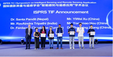
TIF provided 6 travel grants to students and young professionals to attend the ISPRS Technical Commission I Symposium on ‘Intelligent Sensing and Remote Sensing Application’ from 13-17 May 2024 in Changsha, China.  The awardees were Mr. Yongmao Hou (China), Mr. Ravindra Tripathi (India), Mr. YiWei Xu (China), Dr. Santa Pandit (Nepal), Dr. Zhaoning Zhang (China), and Dr. Ferdaous Chaabane (Tunisia). They were invited to the podium in the first Plenary Session of the Symposium and received certificates from ISPRS President, Lena Halounová, accompanied by TIF Grant Evaluation Committee Chair, Stewart Walker. The awardees have reported in their feedback on the benefits gained by attending this event, with special thanks to TIF for their financial assistance in attending this event.

  1. Enriching and Exceptional Experience, by Ferdaous Chaabane
  2. My Experience and Benefits from the ISPRS TC I Symposium, by Santa Pandit
  3. Experience Report, by Ravindra Nath Tripathi
  4. Insights and Experiences, by Yongmao Hou
  5. Reflections on the Mid Term Symposium, by Zhaoning Zhang
TIF awardees receiving certificates from ISPRS President at TC I Symposium.

TIF awardees receiving certificates from ISPRS President at TC I Symposium.


White White

TIF Grants for TC II Symposium in USA, 11-14 June 2024

The ISPRS Foundation (TIF) has announced the awardees of its travel grants to attend the ISPRS Technical Commission II on ‘“The Role of Photogrammetry for a Sustainable World’ from 11-14 June 2024 in Las Vegas, Nevada, USA.  The Grant Evaluation Committee reviewed all the applications submitted for the travel grant and declared the following applicants as awardees. Dr. Priyanka Singh (India), Dr. Francesca Condorelli (Italy), Ms. Pamela Pesántez (Ecuador), Dr. Abdelgwad Elashry (Egypt) and Mr. Youjeong Youn (Republic of Korea). The awardees will receive the sanctioned amount at the venue from one of the office bearers of the ISPRS Council. TIF thanks all the travel grant applicants and congratulates the awardees.

Student Consortium News


ISPRS SC ISPRS SC

ISPRS SC in Changsha: big success and new Chinese friends

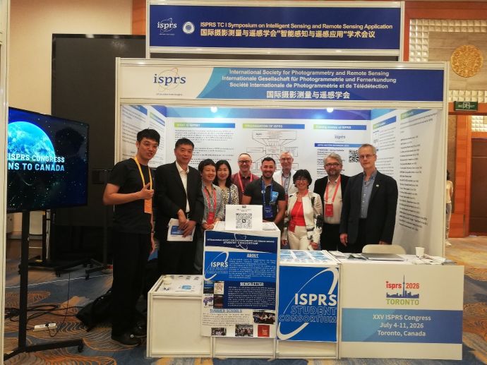
The ISPRS Student Consortium (ISPRS SC) attended ISPRS TC I Symposium on Intelligent Sensing and Remote Sensing Application in Changsha, China, from the 13th to 17th of May 2024, and it was a great success.

Our ISPRS SC Vice President Nicolas Pucino (aka Nick) shared the stall with Wuhan University PhD student Haonan Guo (aka Pole), who helped Nick throughout the whole conference and beyond, bonding not only academically but also on a personal level, surely creating a lasting good relationship between the SC and Wuhan University student community. Moreover, Ms. Liu Lu, (personal assistant of ISPRS Secretary General Jiang Jie) very kindly supported continuously Nick with his mission of onboarding new students and young researchers into the ISPRS SC as we shared the stall with ISPRS Toronto Congress:  thanks to hers and Pole’s help there was minimal language barriers, and many curious students joined the ISPRS SC without hesitations. Nick also took part of a segment of the Council meeting where ISPRS SC matters were discussed, focusing on the student chapters initiation. The experience was amazing, the ISPRS SC grew many new connections and Nick is extremely grateful to the ISPRS Foundation to have funded this trip and to the ISPRS Council for the good times spent together in the conference and during the dinner on the river organised by Wuhan University.

From left to right: Haonan Gao (Wuhan University PhD Student), Tang Xinming (ISPRS Commission I President), Jiang Jie (ISPRS Secretary General), Liu Lu (Jiang Jie Assistant), Derek Lichti (Congress Director), Nicolas Pucino (ISPRS SC Vice President), Stewart Walker (ISPRS Treasurer), Lena Halounová (ISPRS President), Nicolas Paparoditis (ISPRS Vice President) and Christian Heipke (ISPRS Past President).


ISPRS SC Representation at AI for GOOD Global Summit 2024

The ISPRS Student Consortium (ISPRS SC) participated in the AI for Good Summit 2024, organized by the International Telecommunication Union (ITU) on May 30-31 in Geneva, Switzerland.

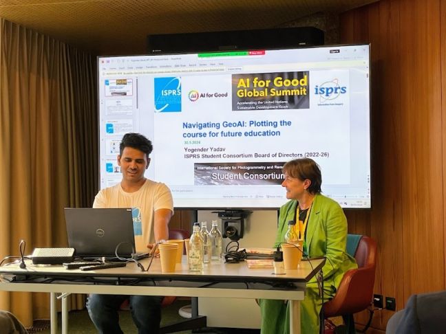
Our ISPRS SC Website Administrator, Yogender Yadav, represented the ISPRS SC on the first day of the conference by attending the workshop titled ‘Navigating GeoAI: Plotting the Course for Future Education.’ The workshop was organized to showcase the accomplishments of four working groups formed to address the need for educational frameworks in GeoAI. The ISPRS SC was invited to share the perceptions of youth regarding the use of AI in the geospatial domain. In this context, the ISPRS SC conducted a questionnaire survey among students and young professionals with backgrounds in GIS, Remote Sensing, and Photogrammetry, and Mr. Yadav shared the survey results during the workshop. Mr. Yadav also discussed the increasing demand for GeoAI expertise, mentioning that proficiency in this field can significantly boost young professionals' employability in various industries. The ISPRS SC's participation in the summit highlighted the expectations of youth in learning GeoAI and GeoAI's crucial role in developing future career and research opportunities for the youth.

Mr Yogender Yadav (on the left) during his presentation at the event. Dr Maria Antonia Brovelli, Professor at Politecnico di Milano and Vice President of the ISPRS TV IV (on the right) moderating the workshop.


ISPRS WG IV/2 Webinar on Remote Sensing based Pollution Identification

ISPRS SC technically supported the ISPRS WG IV/2 webinar organized on June 4, 2024. The webinar, titled ‘Pollution Identification Based on Remote Sensing from UAVs and Multispectral Image Processing,’ was presented by Dr. Konstantin Vytovtov, the lead researcher at the V.A. Trapeznikov Institute of Control Sciences of the Russian Academy of Sciences. Fifty-six people from all around the world attended the webinar, and the presentation was followed by an interactive Q&A session with many questions from the participants.


White White

Upcoming events

ISPRS SC Summer Schools

Title of the event: BUCEA International Summer School on Smart Cities
Date: 14-22 July 2024
Venue: Beijing University of Civil Engineering and Architecture (BUCEA), Beijing, China.
Registration Deadline: 10th June

Theme of the event: AI for Geospatial Applications
Date: 9-13 August 2024
Venue: University of the Philippines, Diliman, Quezon City
This summer school is going to be organized as the post event of the ISPRS Mid-Term Symposium V.

Society News


GSW 2025 GSW 2025

Call for Papers: ISPRS Geospatial Week 2025  

Dubai, United Arab Emirates (UAE)
6th - 11th April 2025

Photogrammetry and Remote Sensing for a Better Tomorrow

Topics

  • Smart Forests and Agriculture 
  • 3D Sensing for Smart Cities
  • Intelligent Uncrewed Vehicles mapping Systems
  • Remote sensing monitoring for urban environment
  • AI for Spatial Data Quality and Uncertainty Modeling in Spatial Analyses
  • Digital Twins and Open Source Empowered HD Maps for Smart Mobility and Autonomy
  • Earth Observation and Geospatial Artificial Intelligence for Disaster Risk Management
  • Resilient High-Precision Positioning, Navigation and Guidance of Autonomous Vehicles
  • Vision Metrology and Uncertainty Assessment
  • Planetary Remote Sensing and Mapping
  • Climate Change and Geospatial research: advanced geospatial research for a sustainable development through International Cooperation
  • Applications of Open Standards, IoT, Crowdsourcing, & Intelligent Systems for Smart Cities Governance & Digital Twin Implementation
  • Semantic Scene Analysis & 3D Reconstruction from Images & Image Sequences
  • Data Management and Data Quality for Remote Sensing Scenarios
  • Digital Construction
  • Laser Scanning 


Important Dates

  1. Annals (Fully Reviewed Papers):
    • Full paper submission (Annals): October 18, 2024
    • Full paper Author notification: January 10, 2025
    • Camera ready paper submission: February 10, 2025
  2. Archives (Abstract Reviewed Papers):
    • Abstracts submission (Archives): December 2, 2024
    • Abstracts Author notification: January 10, 2025
    • Camera ready paper submission: February 10, 2025


ISPRS ISPRS

ISPRS calls for an Organiser of the 2027 Geospatial Week

The ISPRS Geospatial Week (GSW) is a combination of workshops organised by various ISPRS Working Groups and possibly other parties active in the areas of interest of ISPRS and is convened by a local organiser, led by the GSW Director, at a common location. The GSW is held biennially in odd years, preferably in the September/October timeframe. The first one was organised in Antalya in 2013; the next one will take place in Dubai from April 6 to 11, 2025.

Any individual or group of individuals interested in organising GSW 2027 can submit a written bid to ISPRS Council no later than four weeks prior to the opening of GSW 2025, i.e. on 7 March 2025 at the latest. The bid is to be presented in a special session during GSW 2025 and should comprise:

  • a list of tentative workshops to be organised within the GSW, including names of potential workshop organisers (note: a call for workshops can be launched at a later stage)
  • a tentative location and date
  • the name(s) of the prospective GSW 2027 Director, the local organiser(s) and the members of the local organising committee
  • an estimate of the budget and a schedule of proposed registration fees

During GSW 2025, the Geospatial Week Selection Committee selects the site for GSW 2027 from proposals submitted by interested parties.

Voting will take place immediately after a presentation of the bids. The result will be announced in the Closing Session of GSW 2025.

Additional details can be found in the Orange Book including a sample of the GSW contract to be signed. If you have any questions, do not hesitate to contact the ISPRS Secretary General (isprs-sg@isprs.org).

ISPRS Council
2 June 2024


Fritz Ackermann Award Fritz Ackermann Award

The Fritz Ackermann Award – Best Paper 2023

The Fritz Ackermann Award Jury, appointed by the ISPRS Council, evaluated the papers published in the ISPRS Open Journal of Photogrammetry and Remote Sensing in 2023, and announced its decision for the Best Paper. The winner of the 2023 Best Paper Award is:

"Model-based constraints for trajectory determination of quad-copters: Design, calibration & merits for direct orientation”

by Kenneth Joseph Paul, Davide Antonio Cucci, and Jan Skaloud, published in volume 7, January 2023, https://doi.org/10.1016/j.ophoto.2023.100030

Read the announcement here…


Shailesh Nayak Shailesh Nayak

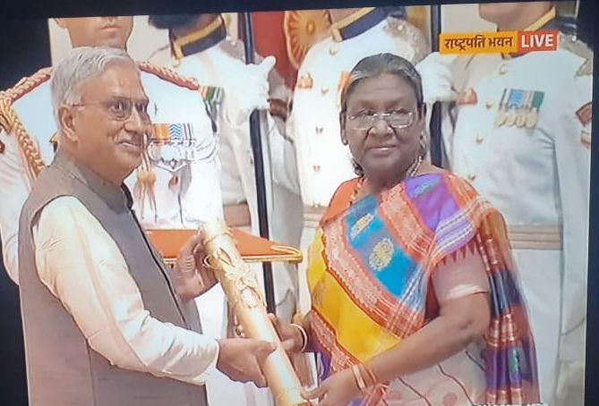
ISPRS Fellow Dr. Shailesh Nayak honoured with 'Padma Shri' in 2024

ISPRS Fellow Dr. Shailesh Nayak, currently Director of the National Institute of Advanced Studies (NIAS), India, was recently honoured with the highest civilian honour of India 'Padma Shri' by the Government of India, in recognition of his outstanding contributions to the field of Science and Engineering. This prestigious award is presented to him by the President of India for distinguished service.

Dr Nayak has showed exemplary leadership in setting up of state-of-art and innovative Centers as well as pioneered techniques and algorithms for the use of space and geospatial technologies for the nation-wide societal benefits. He has provided a new vision and dynamism to the Indian Earth Sciences.


IJGI IJGI

2023 CiteScore of IJGI released

https://www.scopus.com/sourceid/21100427639

The IJGI CiteScore has been increased from 6.2 to 6.9, indicating the continuous progress.

  • CiteScore (2023): 6.9;
  • Ranking in Q1 (92/821) in the category 'Geography, Planning and Development', Scopus;
  • Ranking in Q1 (20/159) in the category 'Earth and Planetary Sciences (miscellaneous)', Scopus;
  • Ranking in Q1 (16/73) in the category 'Computers in Earth Sciences’, Scopus;

Thank you very much for all the effort and time authors and editors have spent on the journal.


IJGI IJGI

Discover the Latest at ISPRS International Journal of Geo-Information (April 2024)

Find the news here»


IJGI IJGI

ISPRS International Journal of Geoinformation Feature Papers from Q1 2024

  1. 3D Cadastral Database Systems—A Systematic Literature Review
    https://www.mdpi.com/2220-9964/13/1/30
  2. Extension of RCC*-9 to Complex and Three-Dimensional Features and Its Reasoning System
    https://www.mdpi.com/2220-9964/13/1/25
  3. Improving Three-Dimensional Building Segmentation on Three-Dimensional City Models through Simulated Data and Contextual Analysis for Building Extraction
    https://www.mdpi.com/2220-9964/13/1/20
  4. Secant Cylinders Are Evil—A Case Study on the Standard Lines of the Universal Transverse Mercator and Universal Polar Stereographic Projections
    https://www.mdpi.com/2220-9964/13/2/56
  5. Cultural Itineraries Generated by Smart Data on the Web
    https://www.mdpi.com/2220-9964/13/2/47
  6. Measuring the Potential and Realized (or Revealed) Spatial Access from Places of Residence and Work to Food Outlets in Rural Communities of Québec, Canada
    https://www.mdpi.com/2220-9964/13/2/43
  7. Conceptualizing and Validating the Trustworthiness of Maps through an Empirical Study on the Influence of Cultural Background on Map Design Perception
    https://www.mdpi.com/2220-9964/13/2/39
  8. Temporal Paths in Real-World Sensor Networks
    https://www.mdpi.com/2220-9964/13/2/36
  9. Evaluation of Qualitative Colour Palettes for Tactile Maps
    https://www.mdpi.com/2220-9964/13/3/94
  10. Sustainable and Resilient Land Use Planning: A Multi-Objective Optimization Approach
    https://www.mdpi.com/2220-9964/13/3/99
  11. Framing VRRSability Relationships among Vulnerability, Risk, Resilience, and Sustainability for Improving Geo-Information Evaluations within Geodesign Decision Support
    https://www.mdpi.com/2220-9964/13/3/67
  12. Superblock Design and Evaluation by a Microscopic Door-to-Door Simulation Approach
    https://www.mdpi.com/2220-9964/13/3/77
  13. Knowledge Graph Representation of Multi-Source Urban Storm Surge Hazard Information Based on Spatio-Temporal Coding and the Hazard Events Ontology Model
    https://www.mdpi.com/2220-9964/13/3/88


General Announcements


HKIS HKIS

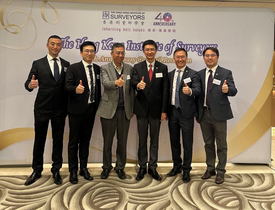
ISPRS representative attended the HKIS 40th Anniversary Cocktail Reception

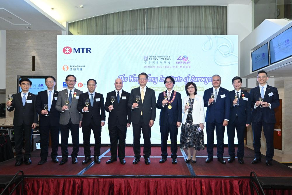
As one of the events celebrating the 40th anniversary of the Hong Kong Institute of Surveyors (HKIS), the HKIS 40th Anniversary Cocktail Reception was successfully held at Hong Kong on 22 March 2024.

Mr. Paul Chan, Financial Secretary of the Hong Kong Special Administrative Region Government, attended the celebration and delivered a speech, saying that the surveying profession has made remarkable contributions to Hong Kong's development and the HKIS has been a driving force in this continuing process with a membership more than 11 000 professionals and students today.

Photo show Mr Paul Chan (centre); the Secretary for Development, Ms Bernadette Linn (fourth right); the President of the HKIS, Mr Francis Lam (fifth right); and other guests giving a toast.

As a representative of the ISPRS, Prof. Bo Wu of the Hong Kong Polytechnic University and Chairman of the ISPRS Working Group III/II “Planetary Remote Sensing and Mapping” attended the event and conveyed ISPRS’s congratulations to HKIS.

Photo show Prof. Bo Wu (third from right) and other guests celebrating.


Raphaële Héno Raphaële Héno

French Ordinary Member, SFPT elects new President, Raphaële Héno

Raphaële Héno, engineer at IGN, is an expert in photogrammetry. She worked between 2006 and 2015 as head of a teaching department at the ENSG geomatique. At that time, she co-wrote a book called “3D modeling of buildings ; outstanding sites”. She worked then for European and international partnerships at IGN. Between 2019 and 2023, she was responsible for the IGN innovation program. Since January 2024, she is deputy manager of the ENSG geomatique.  She has been involved in SFPT for more than 25 years.  She notably organized summer schools in terrestrial photogrammetry under the aegis of the SFPT, and contributed to the setting up of several national symposium.


QR code QR code

Survey on Researchers’ Expectations of Conferences

Are you a researcher planning to attend scientific conferences? 

Please consider participating in and distributing this survey on researchers’ expectations of conferences that Ariane Wenger – a doctoral student at the Transdisciplinarity Lab (TdLab), ETH Zurich – is conducting as part of her dissertation on changing research exchange practices. The short (10 minutes) online survey is aimed at researchers of all scientific disciplines and career stages who are planning to attend scientific conferences. In particular, opinions and views of researchers from all around the world are appreciated. Participation in the survey will not only enrich this study, but will also help to identify avenues for enhancing current conference practices, benefiting the wider academic community. The survey can be accessed here: https://ww3.unipark.de/uc/cexp1/. Thank you very much for your contribution!

Announcements of Scientific Meetings                (see also ISPRS Calendar)


ISPRS SC ISPRScSC

ISPRS SC Summer Schools

BUCEA International Summer School on Smart Cities

14-22 July 2024
Beijing University of Civil Engineering and Architecture (BUCEA), Beijing, China.

Registration Deadline: 10th June
Please see the ISPRS calendar for coming details https://www.isprs.org/calendar/2024.aspx
 

AI for Geospatial Applications

9-13 August 2024
University of the Philippines, Diliman, Quezon City

This summer school will be organized as the post event of the ISPRS Mid-Term Symposium V.
More information: https://www.isprs.org/tc5-symposium2024/page12.html


ACRS 2024 ACRS 2024

45th Asian Conference on Remote Sensing (ACRS 2024)

17 - 21 November 2024
Sri Jayewardenepura Kotte, Sri Lanka

Invitation
1st Announcement

Event Reports


9th GeoLeague Contest 9th GeoLeague Contest

9th GeoLeague Contest Report

9 May 2024
K. N. Toosi University of Technology, Iran

Read the report here…


TC I Symposium TC I Symposium

Report of ISPRS Technical Commission I Symposium

13 - 17 May 2024
Changsha, China

Read the report here…

Obituary


Cemal Özgür Kivilcim Cemal Özgür Kivilcim

Obituary: Cemal Özgür Kivilcim

† 12 May 2024

It is with great sadness that we announce the passing of Dr. Cemal Özgür Kivilcim at the age of 41 on May 12, 2024. Dr. Kivilcim was a distinguished chief engineer at the Istanbul Metropolitan Municipality for over a decade, where he made significant contributions to the field of Geomatics Engineering in his home country, Türkiye, and abroad.

Dr. Kivilcim began his career in Geomatics Engineering at Yildiz Technical University in 2002, and quickly rose through the ranks to become a respected leader in his field. He furthered his education by obtaining both his M.Sc. and Ph.D. degrees from the Department of Geomatics Engineering at Istanbul Technical University in 2009 and 2021, respectively.

Throughout his career, Dr. Kivilcim was actively involved in professional organizations such as the International Federation of Surveyors (FIG) and the International Society for Photogrammetry and Remote Sensing (ISPRS). He held leadership positions within these organizations, including serving as Chair of FIG Working Group 3.6 “Geospatial Next” from 2018 to 2022, and as Co-chair and Secretary of FIG Young Surveyors Network.

Dr. Kivilcim was also a founding member and the chair of the ISPRS Student Consortium from 2007 to 2012. He played a key role in promoting the profession to young people as Co-chair of ISPRS WG V/5 “Promotion of the Profession to Young People”. His dedication and commitment to the field were recognized with prestigious awards, including the ISPRS Willem Schermerhorn Award in 2008 and the FIG Working Week - Future Emerging Issue Award.

Dr. Kivilcim's legacy as a brilliant engineer, dedicated leader, and passionate advocate for the profession will continue to inspire future generations in the field of Geomatics Engineering. He will be deeply missed by all who had the privilege of knowing him.  

Orhan Altan and Devrim Akca
May 2024

ISPRS International Journal of Geo-Information — Open Access Journal


ISPRS International Journal of Geo-Information — Open Access Journal ISPRS International Journal of Geo-Information — Open Access Journal

New publications
Volume 13, Issue 3 (March 2024)

Reconstruction of 3D Information of Buildings from Single-View Images Based on Shadow Information
Li, Zhixin, Ji, Song, Fan, Dazhao, Yan, Zhen, Wang, Fengyi, Wang, Ren
No: 62

A Spatial Regression Model for Predicting Prices of Short-Term Rentals in Athens, Greece
Iliopoulou, Polixeni, Krassanakis, Vassilios, Misthos, Loukas-Moysis, Theodoridi, Christina
No: 63

Learning Universal Trajectory Representation via a Siamese Geography-Aware Transformer
Wu, Chenhao, Xiang, Longgang, Chen, Libiao, Zhong, Qingcen, Wu, Xiongwei
No: 64

Supporting Asset Management with GIS and Business Intelligence Technologies: The Case Study of the University of Turin
Gasbarri, Paola, Accardo, Daniele, Cacciaguerra, Elisa, Meschini, Silvia, Tagliabue, Lavinia Chiara
No: 65

Spatial and Temporal Changes in Social Vulnerability to Natural Hazards in Mexico
León-Cruz, José Francisco, Romero, David, Rodríguez-García, Hugo Ignacio
No: 66

Framing VRRSability Relationships among Vulnerability, Risk, Resilience, and Sustainability for Improving Geo-Information Evaluations within Geodesign Decision Support
Nyerges, Timothy, Gallo, John A., Reynolds, Keith M., Prager, Steven D., Murphy, Philip J., Li, Wenwen
No: 67

Spatial Correlation between the Changes in Supply and Demand for Water-Related Ecosystem Services
Jiang, Yuncheng, Ouyang, Bin, Yan, Zhigang
No: 68

Cartographic Metadata for Improving Accessibility and Facilitating Knowledge Extraction and Validation in Planetary Mapping Based on Remote-Sensing Observations
van Gasselt, Stephan, Naß, Andrea
No: 69

Functional Method for Analyzing Open-Space Ratios around Individual Buildings and Its Implementation with GIS
Okabe, Kayo, Okabe, Atsuyuki
No: 70

Multi-Scale Non-Local Spatio-Temporal Information Fusion Networks for Multi-Step Traffic Flow Forecasting
Lu, Shuai, Chen, Haibo, Teng, Yilong
No: 71

Enhanced Seamless Indoor–Outdoor Tracking Using Time Series of GNSS Positioning Errors
Angelats, Eduard, Gorreja, Alban, Espín-López, Pedro F., Parés, M. Eulàlia, Malinverni, Eva Savina, Pierdicca, Roberto
No: 72

Method for the Identification and Classification of Zones with Vehicular Congestion
Reyes, Gary, Tolozano-Benites, Roberto, Lanzarini, Laura, Estrebou, César, Bariviera, Aurelio F., Barzola-Monteses, Julio
No: 73

Exploring Forest Fire Dynamics: Fire Danger Mapping in Antalya Region, Türkiye
Atalay, Hatice, Dervisoglu, Adalet, Sunar, Ayse Filiz
No: 74

Bayesian Shared Component Spatial Modeling for Assessing the Shared and Age Group-Specific Mental Health Disorder Risk of Young and Old Age Groups: A Case Study of Toronto Neighborhoods, Canada
Abdullah, Abu Yousuf Md, Law, Jane
No: 75

Identifying Spatial Determinants of Rice Yields in Main Producing Areas of China Using Geospatial Machine Learning
Wang, Qingyan, Sun, Longzhi, Yang, Xuan
No: 76

Superblock Design and Evaluation by a Microscopic Door-to-Door Simulation Approach
Nguyen, Ngoc An, Schweizer, Joerg, Rupi, Federico, Palese, Sofia, Posati, Leonardo
No: 77

A Knowledge-Guided Intelligent Analysis Method of Geographic Digital Twin Models: A Case Study on the Diagnosis of Geometric Deformation in Tunnel Excavation Profiles
Liang, Ce, Zhu, Jun, Zhang, Jinbin, Zhu, Qing, Lu, Jingyi, Lai, Jianbo, Wu, Jianlin
No: 78

Hourly PM2.5 Concentration Prediction Based on Empirical Mode Decomposition and Geographically Weighted Neural Network
Chen, Yan, Hu, Chunchun
No: 79

Smart Urban Cadastral Map Enrichment—A Machine Learning Method
Hajiheidari, Alireza, Delavar, Mahmoud Reza, Rajabifard, Abbas
No: 80

What Local Environments Drive Opportunities for Social Events? A New Approach Based on Bayesian Modeling in Dallas, Texas, USA
Yang, Yalin, Wu, Yanan, Yuan, May
No: 81

Spatial Patterns and the Evolution of Logistics Service Node Facilities in Large Cities—A Case from Wuhan
Lu, Jie, Luo, Jing, Tian, Lingling, Tian, Ye
No: 82

A Novel and Extensible Remote Sensing Collaboration Platform: Architecture Design and Prototype Implementation
Gao, Wenqi, Chen, Ninghua, Chen, Jianyu, Gao, Bowen, Xu, Yaochen, Weng, Xuhua, Jiang, Xinhao
No: 83

Modeling Shallow Landslide Runout Distance in Eocene Flysch Facies Using Empirical–Statistical Models (Western Black Sea Region of Türkiye)
Komu, Muge Pinar, Nefeslioglu, Hakan Ahmet, Gokceoglu, Candan
No: 84

Enhancing Maritime Navigational Safety: Ship Trajectory Prediction Using ACoAtt–LSTM and AIS Data
Li, Mingze, Li, Bing, Qi, Zhigang, Li, Jiashuai, Wu, Jiawei
No: 85

Distinguishing the Intervalley Plain from the Intermountain Flat for Landform Mapping Using the Sightline Algorithm
Yan, Ge, Tang, Guoan, Lu, Dingyang, Ma, Junfei, Yang, Xin, Li, Fayuan
No: 86

Crossing Boundaries: The Ethics of AI and Geographic Information Technologies
Oluoch, Isaac
No: 87

Knowledge Graph Representation of Multi-Source Urban Storm Surge Hazard Information Based on Spatio-Temporal Coding and the Hazard Events Ontology Model
Lei, Xinya, Wang, Yuewei, Han, Wei, Song, Weijing
No: 88

Similarity Measurement and Retrieval of Three-Dimensional Voxel Model Based on Symbolic Operator
He, Zhenwen, Liu, Xianzhen, Zhang, Chunfeng
No: 89

ConvTEBiLSTM: A Neural Network Fusing Local and Global Trajectory Features for Field-Road Mode Classification
Bian, Cunxiang, Bai, Jinqiang, Cheng, Guanghe, Hao, Fengqi, Zhao, Xiyuan
No: 90

Simulating Urban Expansion from the Perspective of Spatial Anisotropy and Expansion Neighborhood
Liu, Minghao, Wang, Jianxiang, Luo, Qingxi, Sun, Lingbo, Wang, Enming
No: 91

Quantifying Urban Linguistic Diversity Related to Rainfall and Flood across China with Social Media Data
Qian, Jiale, Du, Yunyan, Liang, Fuyuan, Yi, Jiawei, Wang, Nan, Tu, Wenna, Huang, Sheng, Pei, Tao, Ma, Ting
No: 92

Study on Spatio-Temporal Indexing Model of Geohazard Monitoring Data Based on Data Stream Clustering Algorithm
Li, Jiahao, Song, Weiwei, Chen, Jianglong, Wei, Qunlan, Wang, Jinxia
No: 93

Evaluation of Qualitative Colour Palettes for Tactile Maps
Wabiński, Jakub, Śmiechowska-Petrovskij, Emilia
No: 94

Multiscale Urban Functional Zone Recognition Based on Landmark Semantic Constraints
Xie, Xuejing, Xu, Yongyang, Feng, Bin, Wu, Wenjun
No: 95

Best BiCubic Method to Compute the Planimetric Misregistration between Images with Sub-Pixel Accuracy: Application to Digital Elevation Models
Riazanoff, Serge, Corseaux, Axel, Albinet, Clément, Strobl, Peter A., López-Vázquez, Carlos, Guth, Peter L., Tadono, Takeo
No: 96

A Review of Bayesian Spatiotemporal Models in Spatial Epidemiology
Wang, Yufeng, Chen, Xue, Xue, Feng
No: 97

Spatial Process Analysis of the Evolution of Farmland Landscape in China
Fu, Yan, Qi, Qingwen, Jiang, Lili, Zhao, Yapeng
No: 98

Sustainable and Resilient Land Use Planning: A Multi-Objective Optimization Approach
Sicuaio, Tomé, Zhao, Pengxiang, Pilesjo, Petter, Shindyapin, Andrey, Mansourian, Ali
No: 99

VST-PCA: A Land Use Change Simulation Model Based on Spatiotemporal Feature Extraction and Pre-Allocation Strategy
Liu, Minghao, Luo, Qingxi, Wang, Jianxiang, Sun, Lingbo, Xu, Tingting, Wang, Enming
No: 100

Accuracy Evaluation for Plan-Reliefs and Historical Maps Created during WWI in Northern Italy
Bozzano, Matteo, Sguerso, Domenico, Zatelli, Paolo, Zendri, Davide, Besana, Angelo
No: 101

Dynamics and Predictions of Urban Expansion in Java, Indonesia: Continuity and Change in Mega-Urbanization
Pravitasari, Andrea Emma, Indraprahasta, Galuh Syahbana, Rustiadi, Ernan, Rosandi, Vely Brian, Stanny, Yuri Ardhya, Wulandari, Siti, Priatama, Rista Ardy, Murtadho, Alfin
No: 102

Wetland Classification, Attribute Accuracy, and Scale
Carlson, Kate, Buttenfield, Barbara P., Qiang, Yi
No: 103

A Review of Crowdsourcing Update Methods for High-Definition Maps
Guo, Yuan, Zhou, Jian, Li, Xicheng, Tang, Youchen, Lv, Zhicheng
No: 104

Exploring the Spatiotemporal Effects of the Built Environment on the Nonlinear Impacts of Metro Ridership: Evidence from Xi’an, China
Xi, Yafei, Hou, Quanhua, Duan, Yaqiong, Lei, Kexin, Wu, Yan, Cheng, Qianyu
No: 105


Volume 13, Issue 4 (April 2024)

A Semantic-Spatial Aware Data Conflation Approach for Place Knowledge Graphs
He, Lianlian, Li, Hao, Zhang, Rui
No: 106

Road Accessibility during Natural Hazards Based on Volunteered Geographic Information Data and Network Analysis
Florath, Janine, Chanussot, Jocelyn, Keller, Sina
No: 107

Exploring Travel Mobility in Integrated Usage of Dockless Bike-Sharing and the Metro Based on Multisource Data
Zhang, Hui, Cui, Yu, Liu, Yanjun, Jia, Jianmin, Shi, Baiying, Yu, Xiaohua
No: 108

Spatio-Temporal Evolution Characteristics and Influencing Factors of INGO Activities in Myanmar
Liu, Sicong, Zhang, Yinbao, Liu, Jianzhong, Zhang, Xinjia, Huang, Xiaoshuang
No: 109

Meeting the Challenges of the UN Sustainable Development Goals through Holistic Systems Thinking and Applied Geospatial Ethics
Caudill, Christy M., Pulsifer, Peter L., Thumbadoo, Romola V., Taylor, D. R. Fraser
No: 110

Spatial Analysis of Exposure of Roads to Flooding and Its Implications for Mobility in Urban/Peri-Urban Accra
Yiran, Gerald Albert Baeribameng, Oteng Ababio, Martin, Allotey, Albert Nii Moe, Kofie, Richard Yao, Møller-Jensen, Lasse
No: 111

Measuring the Spatial-Temporal Heterogeneity of Helplessness Sentiment and Its Built Environment Determinants during the COVID-19 Quarantines: A Case Study in Shanghai
He, Yuhao, Zhao, Qianlong, Sun, Shanqi, Li, Wenjing, Qiu, Waishan
No: 112

Connection of Conic and Cylindrical Map Projections
Lapaine, Miljenko
No: 113

Mapping Street Patterns with Network Science and Supervised Machine Learning
Wu, Cai, Wang, Yanwen, Wang, Jiong, Kraak, Menno-Jan, Wang, Mingshu
No: 114

Analyzing the Influence of Visitor Types on Location Choices and Revisit Intentions in Urban Heritage Destinations
Karayazi, Sevim Sezi, Dane, Gamze, Arentze, Theo
No: 115

An Integrated Duranton and Overman Index and Local Duranton and Overman Index Framework for Industrial Spatial Agglomeration Pattern Analysis
Huang, Yupu, Zhuo, Li, Cao, Jingjing
No: 116

Analysis of Spatiotemporal Dynamics of Land Desertification in Qilian Mountain National Park Based on Google Earth Engine
Chen, Xiaowen, Wang, Naiang, Peng, Simin, Meng, Nan, Lv, Haoyun
No: 117

Animating Cartographic Meaning: Unveiling the Impact of Pictorial Symbol Motion Speed in Preattentive Processing
Cybulski, Paweł
No: 118

Low-Cost Data, High-Quality Models: A Semi-Automated Approach to LOD3 Creation
Harshit, Chaurasia, Pallavi, Zlatanova, Sisi, Jain, Kamal
No: 119

How Does the 2D/3D Urban Morphology Affect the Urban Heat Island across Urban Functional Zones? A Case Study of Beijing, China
Du, Shouhang, Wu, Yuhui, Guo, Liyuan, Fan, Deqin, Sun, Wenbin
No: 120

Mapping the CityGML Energy ADE to CityGML 3.0 Using a Model-Driven Approach
Bachert, Carolin, León-Sánchez, Camilo, Kutzner, Tatjana, Agugiaro, Giorgio
No: 121

Balancing Flood Control and Economic Development in Flood Detention Areas of the Yangtze River Basin
Liao, Siyuan, Wang, Chao, Ji, Renke, Zhang, Xiang, Wang, Zhifei, Wang, Wei, Chen, Nengcheng
No: 122

Variability of Extreme Climate Events and Prediction of Land Cover Change and Future Climate Change Effects on the Streamflow in Southeast Queensland, Australia
Pakdel, Hadis, Chadalavada, Sreeni, Alam, Md Jahangir, Paudyal, Dev Raj, Vazifedoust, Majid
No: 123

Mapmaking Process Reading from Local Distortions in Historical Maps: A Geographically Weighted Bidimensional Regression Analysis of a Japanese Castle Map
Yabe, Naoto
No: 124

Enhancing Adversarial Learning-Based Change Detection in Imbalanced Datasets Using Artificial Image Generation and Attention Mechanism
Oubara, Amel, Wu, Falin, Maleki, Reza, Ma, Boyi, Amamra, Abdenour, Yang, Gongliu
No: 125

Comparison of Different Green Space Measures and Their Impact on Dementia Cases in South Korea: A Spatial Panel Analysis
Karurung, Wulan Salle, Lee, Kangjae, Lee, Wonhee
No: 126

Map Reading and Analysis with GPT-4V(ision)
Xu, Jinwen, Tao, Ran
No: 127

Search Engine for Open Geospatial Consortium Web Services Improving Discoverability through Natural Language Processing-Based Processing and Ranking
Ferrari, Elia, Striewski, Friedrich, Tiefenbacher, Fiona, Bereuter, Pia, Oesch, David, Di Donato, Pasquale
No: 128

Spatial Relationship of Inter-City Population Movement and Socio-Economic Determinants: A Case Study in China Using Multiscale Geographically Weighted Regression
Liu, Sihan, Niu, Xinyi
No: 129

Multi-Criteria Framework for Routing on Access Land: A Case Study on Dartmoor National Park
Sprent, Rafael Felipe, Haworth, James, Cavazzi, Stefano, Ilyankou, Ilya
No: 130

Unveiling the Non-Linear Influence of Eye-Level Streetscape Factors on Walking Preference: Evidence from Tokyo
Huang, Lu, Oki, Takuya, Muto, Sachio, Ogawa, Yoshiki
No: 131

Evaluating the Impact of Human Activities on Vegetation Restoration in Mining Areas Based on the GTWR
Guo, Li, Li, Jun, Zhang, Chengye, Xu, Yaling, Xing, Jianghe, Hu, Jingyu
No: 132

An LLM-Based Inventory Construction Framework of Urban Ground Collapse Events with Spatiotemporal Locations
Hao, Yanan, Qi, Jin, Ma, Xiaowen, Wu, Sensen, Liu, Renyi, Zhang, Xiaoyi
No: 133

Spatiotemporal Analysis of Water Body in the Chongming Island Region over the Past Decade Based on the ISUNet Model
Miao, Lizhi, Feng, Xinkai, Yang, Lijun, Ren, Yanhui, Deng, Yamei, Hang, Tian
No: 134

A Hierarchy-Aware Geocoding Model Based on Cross-Attention within the Seq2Seq Framework
Liang, Linlin, Chang, Yuanfei, Quan, Yizhuo, Wang, Chengbo
No: 135

Comprehension of City Map Pictograms Designed for Specific Tourists’ Needs
Kovačević, Dorotea, Brozović, Maja, Možina, Klementina
No: 137

Scale Distribution of Retail Formats in the Central Districts of Chinese Cities: A Study Analysis of Ten Cities
Shi, Yi, Wang, Yidian, Ren, Yifan, Zhou, Chunyu, Hu, Xinyu
No: 136

A Novel Address-Matching Framework Based on Region Proposal
Quan, Yizhuo, Chang, Yuanfei, Liang, Linlin, Qiao, Yanyou, Wang, Chengbo
No: 138

Research on the Spatial Network Structure of Tourist Flows in Hangzhou Based on BERT-BiLSTM-CRF
Qi, Danfeng, Wang, Bingbing, Zhao, Qiuhao, Jin, Pingbin
No: 139

AED Inequity among Social Groups in Guangzhou
Gao, Feng, Lu, Siyi, Liao, Shunyi, Chen, Wangyang, Chen, Xin, Wu, Jiemin, Wu, Yunjing, Li, Guanyao, Han, Xu
No: 140


Volume 13, Issue 5 (May 2024)

A Sensor-Based Simulation Method for Spatiotemporal Event Detection
Jiang, Yuqin, Popov, Andrey A., Li, Zhenlong, Hodgson, Michael E., Huang, Binghu
No: 141

Integrating Spatial and Non-Spatial Dimensions to Evaluate Access to Rural Primary Healthcare Service: A Case Study of Songzi, China
Yang, Taohua, Luo, Weicong, Tian, Lingling, Li, Jinpeng
No: 142

Discovering Links between Geospatial Data Sources in the Web of Data: The Open Geospatial Engine Approach
He, Lianlian, Liu, Ruixiang
No: 143

Spatiotemporal Evolution and Influencing Factors of Urban Industry in Modern China (1840–1949): A Case Study of Nanjing
Wang, Chun, Chen, Gang, Liang, Yixin
No: 144

Evolution Characteristics and Influencing Factors of City Networks in China: A Case Study of Cross-Regional Automobile Enterprises
Xu, Daming, Shen, Weiliang
No: 145

Exploring the Pedestrian Route Choice Behaviors by Machine Learning Models
Jin, Cheng-Jie, Luo, Yuanwei, Wu, Chenyang, Song, Yuchen, Li, Dawei
No: 146

Optimization of Shared Electric Scooter Deployment Stations Based on Distance Tolerance
Yue, Jianwei, Long, Yingqiu, Wang, Shaohua, Liang, Haojian
No: 147

A Methodology for Designing One-Way Station-Based Carsharing Services in a GIS Environment: A Case Study in Palermo
D’Orso, Gabriele, Migliore, Marco
No: 148

Comparing Machine Learning and Time Series Approaches in Predictive Modeling of Urban Fire Incidents: A Case Study of Austin, Texas
Yuan, Yihong, Wylie, Andrew Grayson
No: 149

Delineating Source and Sink Zones of Trip Journeys in the Road Network Space
Shi, Yan, Chen, Bingrong, Huang, Jincai, Wang, Da, Liu, Huimin, Deng, Min
No: 150

Prediction of Parking Space Availability Using Improved MAT-LSTM Network
Zhang, Feizhou, Shang, Ke, Yan, Lei, Nan, Haijing, Miao, Zicong
No: 151

A Quantitative and Qualitative Experimental Framework for the Evaluation of Urban Soundscapes: Application to the City of Sidi Bou Saïd
Hammami, Mohamed Amin, Claramunt, Christophe
No: 152

Exploration of an Open Vocabulary Model on Semantic Segmentation for Street Scene Imagery
Zeng, Zichao, Boehm, Jan
No: 153

Collaborative Methods of Resolving Road Graphic Conflicts Based on Cartographic Rules and Generalization Operations
Zheng, Chuanbang, Guo, Qingsheng, Wang, Lin, Liu, Yuangang, Jiang, Jianfeng
No: 154

An Adaptive Simplification Method for Coastlines Using a Skeleton Line “Bridge” Double Direction Buffering Algorithm
Tang, Lulu, Zhang, Lihua, Dong, Jian, Wei, Hongcheng, Wei, Shuai
No: 155

A Multi-Feature Fusion Method for Urban Functional Regions Identification: A Case Study of Xi’an, China
Wang, Zhuo, Bai, Jianjun, Feng, Ruitao
No: 156

Spatial and Temporal Analysis of Road Traffic Accidents in Major Californian Cities Using a Geographic Information System
Alsahfi, Tariq
No: 157

Oil Palm Bunch Ripeness Classification and Plantation Verification Platform: Leveraging Deep Learning and Geospatial Analysis and Visualization
Puttinaovarat, Supattra, Chai-Arayalert, Supaporn, Saetang, Wanida
No: 158

Total Least Squares Estimation in Hedonic House Price Models
Zhan, Wenxi, Hu, Yu, Zeng, Wenxian, Fang, Xing, Kang, Xionghua, Li, Dawei
No: 159

Towards Quality Management Procedures in 3D Cadastre
Višnjevac, Nenad, Šoškić, Mladen, Mihajlović, Rajica
No: 160

Land Subsidence Susceptibility Mapping in Ca Mau Province, Vietnam, Using Boosting Models
Tran, Anh Van, Brovelli, Maria Antonia, Ha, Khien Trung, Khuc, Dong Thanh, Tran, Duong Nhat, Tran, Hanh Hong, Le, Nghi Thanh
No: 161

Leveraging Transfer Learning and U-Nets Method for Improved Gap Filling in Himawari Sea Surface Temperature Data Adjacent to Taiwan
Putra, Dimas Pradana, Hsu, Po-Chun
No: 162

VIS-SLAM: A Real-Time Dynamic SLAM Algorithm Based on the Fusion of Visual, Inertial, and Semantic Information
Wang, Yinglong, Liu, Xiaoxiong, Zhao, Minkun, Xu, Xinlong
No: 163

Changes in the 19th Century Cultural Landscape with Regard to City Rights in Western Poland
Lorek, Dariusz, Horbiński, Tymoteusz
No: 164

A Question and Answering Service of Typhoon Disasters Based on the T5 Large Language Model
Xia, Yongqi, Huang, Yi, Qiu, Qianqian, Zhang, Xueying, Miao, Lizhi, Chen, Yixiang
No: 165

Improved A* Navigation Path-Planning Algorithm Based on Hexagonal Grid
An, Zehua, Rui, Xiaoping, Gao, Chaojie
No: 166

Community Quality Evaluation for Socially Sustainable Regeneration: A Study Using Multi-Sourced Geospatial Data and AI-Based Image Semantic Segmentation
Chen, Jinliu, Gan, Wenquan, Liu, Ning, Li, Pengcheng, Wang, Haoqi, Zhao, Xiaoxin, Yang, Di
No: 167


ISPRS Journal of Photogrammetry and Remote Sensing


ISPRS Journal ISPRS Journal

New publications
Volume 210 (April 2024)

Editorial Board
Pages: ii

PROSAIL-Net: A transfer learning-based dual stream neural network to estimate leaf chlorophyll and leaf angle of crops from UAV hyperspectral images
Sourav Bhadra, Vasit Sagan, Supria Sarkar, Maxwell Braud, Todd C. Mockler, Andrea L. Eveland
Pages: 1-24

Quantifying the impact of urban trees on land surface temperature in global cities
Tingting He, Yihua Hu, Andong Guo, Yuwei Chen, Jun Yang, Mengmeng Li, Maoxin Zhang
Pages: 69-79

The One-Point-One-Line geometry for robust and efficient line segment correspondence
Haoyu Guo, Dong Wei, Yongjun Zhang, Yi Wan, Zhi Zheng, Yongxiang Yao, Xinyi Liu, Zhuofan Li
Pages: 80-96

Semantics-enhanced discriminative descriptor learning for LiDAR-based place recognition
Yiwen Chen, Yuan Zhuang, Jianzhu Huai, Qipeng Li, Binliang Wang, Nashwa El-Bendary, Alper Yilmaz
Pages: 97-109

Low-altitude remote sensing-based global 3D path planning for precision navigation of agriculture vehicles - beyond crop row detection
Dongfang Li, Boliao Li, Huaiqu Feng, Shuo Kang, Jun Wang, Zhenbo Wei
Pages: 25-38

Evaluation of Landsat-9 interoperability with Sentinel-2 and Landsat-8 over Europe and local comparison with field surveys
F. Trevisiol, E. Mandanici, A. Pagliarani, G. Bitelli
Pages: 55-68

Evaluation of PlanetScope-detected plant-specific phenology using infrared-enabled PhenoCam observations in semi-arid ecosystems
Yuxia Liu, Xiaoyang Zhang, Yu Shen, Yongchang Ye, Shuai Gao, Khuong H. Tran
Pages: 242-259

Recognition for SAR deformation military target from a new MiniSAR dataset using multi-view joint transformer approach
Jiming Lv, Daiyin Zhu, Zhe Geng, Shengliang Han, Yu Wang, Zheng Ye, Tao Zhou, Hongren Chen, Jiawei Huang
Pages: 180-197

A robust data-model dual-driven fusion with uncertainty estimation for LiDAR–IMU localization system
Qipeng Li, Yuan Zhuang, Jianzhu Huai, Xuan Wang, Binliang Wang, Yue Cao
Pages: 128-140

Detecting Marine pollutants and Sea Surface features with Deep learning in Sentinel-2 imagery
Katerina Kikaki, Ioannis Kakogeorgiou, Ibrahim Hoteit, Konstantinos Karantzalos
Pages: 39-54

Satellite video single object tracking: A systematic review and an oriented object tracking benchmark
Yuzeng Chen, Yuqi Tang, Yi Xiao, Qiangqiang Yuan, Yuwei Zhang, Fengqing Liu, Jiang He, Liangpei Zhang
Pages: 212-240

Bridging the gap between crop breeding and GeoAI: Soybean yield prediction from multispectral UAV images with transfer learning
Juan Skobalski, Vasit Sagan, Haireti Alifu, Omar {Al Akkad}, Felipe A. Lopes, Fernando Grignola
Pages: 260-281

Changes in the Team of Associate Editors
Qihao Weng, Clément Malle
Pages: 241

WPS:A whole phenology-based spectral feature selection method for mapping winter crop from time-series images
Man Liu, Wei He, Hongyan Zhang
Pages: 141-159

An enhanced large-scale benthic reflectance retrieval model for the remote sensing of submerged ecosystems in optically shallow waters
Yuxin Wang, Xianqiang He, Palanisamy Shanmugam, Yan Bai, Teng Li, Difeng Wang, Qiankun Zhu, Fang Gong
Pages: 160-179

Enhancing deforestation monitoring in the Brazilian Amazon: A semi-automatic approach leveraging uncertainty estimation
Jorge Andres Chamorro Martinez, Gilson A. Ostwald Pedro {da Costa}, Cassiano Gustavo Messias, Luciana de Souza Soler, Claudio A. {de Almeida}, Raul Queiroz Feitosa
Pages: 110-127

Plant-Denoising-Net (PDN): A plant point cloud denoising network based on density gradient field learning
Jianeng Wu, Lirong Xiang, Hui You, Lie Tang, Jingyao Gai
Pages: 282-299

A novel algorithm for ocean chlorophyll-a concentration using MODIS Aqua data
Julian Merder, Gang Zhao, Nima Pahlevan, Robert A. Rigby, Dimitrios M. Stasinopoulos, Anna M. Michalak
Pages: 198-211


New publications
Volume 211 (May 2024)

Editorial Board
Pages: ii

Integrating physical model and image simulations to correct topographic effects on surface reflectance
Wentao Yu, Huabing Huang, Qiang Liu, Jie Wang
Pages: 356-371

Corrigendum to “ReCuSum: A polyvalent method to monitor tropical forest disturbances” [ISPRS J. Photogramm. Rem. Sens. 203 (2023) 358–372]
Bertrand Ygorra, Frédéric Frappart, Jean-Pierre Wigneron, Christophe Moisy, Thibault Catry, Benjamin Pillot, Jonas Courtalon, Anna Kharlanova, Serge Riazanof
Pages: 298

Maize stem–leaf segmentation framework based on deformable point clouds
Xin Yang, Teng Miao, Xueying Tian, Dabao Wang, Jianxiang Zhao, Lili Lin, Chao Zhu, Tao Yang, Tongyu Xu
Pages: 49-66

A satellite-field phenological bridging framework for characterizing community-level spring forest phenology using multi-scale satellite imagery
Chunyuan Diao, Carol K. Augspurger, Yilun Zhao, Carl F. Salk
Pages: 83-103

Semantic change detection using a hierarchical semantic graph interaction network from high-resolution remote sensing images
Jiang Long, Mengmeng Li, Xiaoqin Wang, Alfred Stein
Pages: 318-335

Global mapping of fractional tree cover for forest cover change analysis
Yang Liu, Ronggao Liu, Lin Qi, Jilong Chen, Jinwei Dong, Xuexin Wei
Pages: 67-82

Making satellite-derived empirical bathymetry independent of high-quality in-situ depth data: An assessment of four possible model calibration data
Bin Cao, Hui Liu, Bincai Cao
Pages: 336-355

First retrieval of daily 160 m aerosol optical depth over urban areas using Gaofen-1/6 synergistic observations: Algorithm development and validation
Jiadan Dong, Tianhao Zhang, Lunche Wang, Zhengqiang Li, Man {Sing Wong}, Muhammad Bilal, Zhongmin Zhu, Feiyue Mao, Xinghui Xia, Ge Han, Qiangqiang Xu, Yu Gu, Yun Lin, Bin Zhao, Zhiwei Li, Kai Xu, Xiaoling Chen, Wei Gong
Pages: 372-391

Forecasting corn NDVI through AI-based approaches using sentinel 2 image time series
A. Farbo, F. Sarvia, S. {De Petris}, V. Basile, E. Borgogno-Mondino
Pages: 244-261

The SAR2Height framework for urban height map reconstruction from single SAR intensity images
Michael Recla, Michael Schmitt
Pages: 104-120

On the reachability and genesis of water ice on the Moon
Tathagata Chakraborty, Tajdarul Hassan Syed, Essam Heggy, Deepak Putrevu, Upama Dutta
Pages: 392-405

Bundle adjustment with motion constraints for uncalibrated multi-camera systems at the ground level
Debao Huang, Rongjun Qin, Mostafa Elhashash
Pages: 452-464

PAL-SLAM2: Visual and visual–inertial monocular SLAM for panoramic annular lens
Ding Wang, Junhua Wang, Yuhan Tian, Yi Fang, Zheng Yuan, Min Xu
Pages: 35-48

TemPanSharpening: A multi-temporal Pansharpening solution based on deep learning and edge extraction
Yifei Han, Hong Chi, Jinliang Huang, Xinyi Gao, Zhiyu Zhang, Feng Ling
Pages: 406-424

APC2Mesh: Bridging the gap from occluded building façades to full 3D models
Perpetual {Hope Akwensi}, Akshay Bharadwaj, Ruisheng Wang
Pages: 438-451

Corrigendum to “Ground subsidence in Tucson, Arizona, monitored by time-series analysis using multi-sensor InSAR datasets from 1993 to 2011” [ISPRS J. Photogramm. Remote Sens. 107 (2015) 126–141]
Jin-Woo Kim, Zhong Lu, Yuanyuan Jia, C.K. Shu
Pages: 171

Unsupervised shape-aware SOM down-sampling for plant point clouds
Dawei Li, Zhaoyi Zhou, Yongchang Wei
Pages: 172-207

A Variance-Covariance method to estimating the errors of 3-D ground displacement time-series using small baseline InSAR algorithms and multi-platform SAR data
Francesco Falabella, Antonio Pepe, Angela Perrone, Tony Alfredo Stabile
Pages: 208-227

PLANES4LOD2: Reconstruction of LoD-2 building models using a depth attention-based fully convolutional neural network
Philipp Schuegraf, Jie Shan, Ksenia Bittner
Pages: 425-437

Methods and datasets on semantic segmentation for Unmanned Aerial Vehicle remote sensing images: A review
Jian Cheng, Changjian Deng, Yanzhou Su, Zeyu An, Qi Wang
Pages: 1-34

Enhanced wavelet based spatiotemporal fusion networks using cross-paired remote sensing images
Xingjian Zhang, Shuang Li, Zhenyu Tan, Xinghua Li
Pages: 281-297

Robust remote sensing retrieval of key eutrophication indicators in coastal waters based on explainable machine learning
Liudi Zhu, Tingwei Cui, A Runa, Xinliang Pan, Wenjing Zhao, Jinzhao Xiang, Mengmeng Cao
Pages: 262-280

The ClearSCD model: Comprehensively leveraging semantics and change relationships for semantic change detection in high spatial resolution remote sensing imagery
Kai Tang, Fei Xu, Xuehong Chen, Qi Dong, Yuheng Yuan, Jin Chen
Pages: 299-317

Joint target and background temporal propagation for aerial tracking
Xu Lei, Wensheng Cheng, Chang Xu, Wen Yang
Pages: 121-134

Efficient structure from motion for UAV images via anchor-free parallel merging
San Jiang, Yichen Ma, Wanshou Jiang, Qingquan Li
Pages: 156-170

HCTO: Optimality-aware LiDAR inertial odometry with hybrid continuous time optimization for compact wearable mapping system
Jianping Li, Shenghai Yuan, Muqing Cao, Thien-Minh Nguyen, Kun Cao, Lihua Xie
Pages: 228-243

AiTARs-Net: A novel network for detecting arbitrary-oriented transverse aeolian ridges from Tianwen-1 HiRIC images
Zhen Cao, Zhizhong Kang, Teng Hu, Ze Yang, Dong Chen, Xiaolan Ren, Qingyu Meng, Dong Wang
Pages: 135-155

GlobalMind: Global multi-head interactive self-attention network for hyperspectral change detection
Meiqi Hu, Chen Wu, Liangpei Zhang
Pages: 465-483


New publications
Volume 212 (June 2024)

Editorial Board

Pages: ii

Towards multi-views cloud retrieval accounting for the 3-D structure collected by directional polarization camera
Haixiao Yu, Xiaobing Sun, Bihai Tu, Rufang Ti, Jinji Ma, Jin Hong, Cheng Chen, Xiao Liu, Honglian Huang, Zeling Wang, Safura Ahmad, Yi Wang, Yizhe Fan, Yiqi Li, Yichen Wei, Yuxuan Wang, Yuyao Wang
Pages: 146-163

Low-severity spruce beetle infestation mapped from high-resolution satellite imagery with a convolutional network
S. Zwieback, J. Young-Robertson, M. Robertson, Y. Tian, Q. Chang, M. Morris, J. White, J. Moan
Pages: 412-421

Forest feature LiDAR SLAM (F2-LSLAM) for backpack systems
Tian Zhou, Chunxi Zhao, Cameron Patrick Wingren, Songlin Fei, Ayman Habib
Pages: 96-121

Continent-wide urban tree canopy fine-scale mapping and coverage assessment in South America with high-resolution satellite images
Jianhua Guo, Danfeng Hong, Zhiheng Liu, Xiao Xiang Zhu
Pages: 251-273

Towards real-time processing for UAV-mounted GPR-SAR imaging systems
María García-Fernández, Guillermo Álvarez-Narciandi, Jaime Laviada, Yuri Álvarez López, Fernando Las-Heras
Pages: 1-12

Combining deep learning with physical parameters in POC and PIC inversion from spaceborne lidar CALIOP
Zhenhua Zhang, Siqi Zhang, Michael J. Behrenfeld, Peng Chen, Cédric Jamet, Paolo {Di Girolamo}, Davide Dionisi, Yongxiang Hu, Xiaomei Lu, Yuliang Pan, Minzhe Luo, Haiqing Huang, Delu Pan
Pages: 193-211

Chat3D: Interactive understanding 3D scene-level point clouds by chatting with foundation model for urban ecological construction
Yiping Chen, Shuai Zhang, Ting Han, Yumeng Du, Wuming Zhang, Jonathan Li
Pages: 181-192

Lightweight and rotation-invariant place recognition network for large-scale raw point clouds
Zhenghua Zhang, Hu Liu, Xuan Wang, Mingcong Shu, Guoliang Chen, Qiuzhao Zhang
Pages: 58-72

EarthVQANet: Multi-task visual question answering for remote sensing image understanding
Junjue Wang, Ailong Ma, Zihang Chen, Zhuo Zheng, Yuting Wan, Liangpei Zhang, Yanfei Zhong
Pages: 422-439

Scattering power components from dual-pol Sentinel-1 SLC and GRD SAR data
Abhinav Verma, Avik Bhattacharya, Subhadip Dey, Carlos López-Martínez, Paolo Gamba
Pages: 289-305

Decouple and weight semi-supervised semantic segmentation of remote sensing images
Wei Huang, Yilei Shi, Zhitong Xiong, Xiao Xiang Zhu
Pages: 13-26

Effect of intra-year Landsat scene availability in land cover land use classification in the conterminous United States using deep neural networks
Giorgos Mountrakis, Shahriar S. Heydari
Pages: 164-180

National-scale nighttime high-temperature anomalies from Landsat-8 OLI images
Huansha Wu, Yongxue Liu, Yulin Pu, Peng Liu, Wanjing Zhao, Xiaoxiao Guo
Pages: 212-229

Unmixing-based radiometric and spectral harmonization for consistency of multi-sensor reflectance time-series data
Kenta Obata, Hiroki Yoshioka
Pages: 396-411

Meta-Calib: A generic, robust and accurate camera calibration framework with ArUco-encoded meta-board
Pengwei Zhou, Hongche Yin, Guozheng Xu, Li Li, Jian Yao, Jian Li, Changfeng Liu, Zuoqin Shi
Pages: 357-380

Adversarial learning-based camera pose-to-image mapping network for synthesizing new view in real indoor environments
Xujie Kang, Kangling Liu, Jiang Duan, Yuanhao Gong, Guoping Qiu
Pages: 27-41

Deep learning-based harmonization and super-resolution of Landsat-8 and Sentinel-2 images
Venkatesh Thirugnana Sambandham, Konstantin Kirchheim, Frank Ortmeier, Sayan Mukhopadhaya
Pages: 274-288

Toulouse Hyperspectral Data Set: A benchmark data set to assess semi-supervised spectral representation learning and pixel-wise classification techniques
Romain Thoreau, Laurent Risser, Véronique Achard, Béatrice Berthelot, Xavier Briottet
Pages: 323-337

DAM-Net: Flood detection from SAR imagery using differential attention metric-based vision transformers
Tamer Saleh, Xingxing Weng, Shimaa Holail, Chen Hao, Gui-Song Xia
Pages: 440-453

Characterizing foliar phenolic compounds and their absorption features in temperate forests using leaf spectroscopy
Rui Xie, Roshanak Darvishzadeh, Andrew Skidmore, Freek {van der Meer}
Pages: 338-356

Rapid in-flight image quality check for UAV-enabled bridge inspection
Feng Wang, Yang Zou, Xiaoyu Chen, Cheng Zhang, Lei Hou, Enrique {del Rey Castillo}, James B.P. Lim
Pages: 230-250

A coarse-to-fine visual geo-localization method for GNSS-denied UAV with oblique-view imagery
Qin Ye, Junqi Luo, Yi Lin
Pages: 306-322

Identifying cropland non-agriculturalization with high representational consistency from bi-temporal high-resolution remote sensing images: From benchmark datasets to real-world application
Zhendong Sun, Yanfei Zhong, Xinyu Wang, Liangpei Zhang
Pages: 454-474

Linearly interpolating missing values in time series helps little for land cover classification using recurrent or attention networks
Xianghong Che, Hankui K. Zhang, Zhongbin B. Li, Yong Wang, Qing Sun, Dong Luo, Hao Wang
Pages: 73-95

Neural implicit shape modeling for small planetary bodies from multi-view images using a mask-based classification sampling strategy
Hao Chen, Xuanyu Hu, Konrad Willner, Zhen Ye, Friedrich Damme, Philipp Gläser, Yongjie Zheng, Xiaohua Tong, Hauke Hußmann, Jürgen Oberst
Pages: 122-145

SC-CNN: LiDAR point cloud filtering CNN under slope and copula correlation constraint
Ruixing Chen, Jun Wu, Xuemei Zhao, Ying Luo, Gang X
Pages: 381-395

A feature selection method for multimodal multispectral LiDAR sensing
Yu Han, David Salido-Monzú, Jemil Avers Butt, Sebastian Schweizer, Andreas Wieser
Pages: 42-57


New publications
Volume 213 (July 2024)

Editorial Board
Pages: ii

Regression model for speckled data with extreme variability
Abraão D.C. Nascimento, Josimar M. Vasconcelos, Renato J. Cintra, Alejandro C. Frery
Pages: 1-13

Incremental registration towards large-scale heterogeneous point clouds by hierarchical graph matching
Shoujun Jia, Chun Liu, Hangbin Wu, Weihua Huan, Shufan Wang
Pages: 87-106

A novel and robust method for large-scale single-season rice mapping based on phenology and statistical data
Maolin Yang, Bin Guo, Jianlin Wang
Pages: 14-32

TSI-Siamnet: A Siamese network for cloud and shadow detection based on time-series cloudy images
Qunming Wang, Jiayi Li, Xiaohua Tong, Peter M. Atkinson
Pages: 107-123

Vectorized building extraction from high-resolution remote sensing images using spatial cognitive graph convolution model
Zhuotong Du, Haigang Sui, Qiming Zhou, Mingting Zhou, Weiyue Shi, Jianxun Wang, Junyi Liu
Pages: 53-71

Evaluating the spatial–temporal transferability of models for agricultural land cover mapping using Landsat archive
Jayan Wijesingha, Ilze Dzene, Michael Wachendorf
Pages: 72-86

Detection and attribution of cereal yield losses using Sentinel-2 and weather data: A case study in South Australia
Keke Duan, Anton Vrieling, Michael Schlund, Uday {Bhaskar Nidumolu}, Christina Ratcliff, Simon Collings, Andrew Nelson
Pages: 33-52


ISPRS Open Journal of Photogrammetry and Remote Sensing


ISPRS Open Journal of Photogrammetry and Remote Sensing ISPRS Open Journal of Photogrammetry and Remote Sensing

New publications
Volume 12 (April 2024)

Natural color dispersion of corbicular pollen limits color-based classification
Parzival Borlinghaus, Frederic Tausch, Richard Odemer
Pages: 100063

Improving spatial transferability of deep learning models for small-field crop yield prediction
Stefan Stiller, Kathrin Grahmann, Gohar Ghazaryan, Masahiro Ryo
Pages: 100064

Photogrammetric rockfall monitoring in Alpine environments using M3C2 and tracked motion vectors
Lukas Lucks, Uwe Stilla, Ludwig Hoegner, Christoph Holst
Pages: 100058

Integrating multi-user digitising actions for mapping gully outlines using a combined approach of Kalman filtering and machine learning
Miguel {Vallejo Orti}, Katharina Anders, Oluibukun Ajayi, Olaf Bubenzer, Bernhard Höfle
Pages: 100059

End-to-end simulations to optimize imaging spectroscopy mission requirements for seven scientific applications
X. Briottet, K. Adeline, T. Bajjouk, V. Carrère, M. Chami, Y. Constans, Y. Derimian, A. Dupiau, M. Dumont, S. Doz, S. Fabre, P.Y. Foucher, H. Herbin, S. Jacquemoud, M. Lang, A. {Le Bris}, P. Litvinov, S. Loyer, R. Marion, A. Minghelli, T. Miraglio, D. Sheeren, B. Szymanski, F. Romand, C. Desjardins, D. Rodat, B. Cheul
Pages: 100060

Deep learning techniques for hyperspectral image analysis in agriculture: A review
Mohamed Fadhlallah Guerri, Cosimo Distante, Paolo Spagnolo, Fares Bougourzi, Abdelmalik Taleb-Ahmed
Pages: 100062

Semantic segmentation of raw multispectral laser scanning data from urban environments with deep neural networks
Mikael Reichler, Josef Taher, Petri Manninen, Harri Kaartinen, Juha Hyyppä, Antero Kukko
Pages: 100061

Airborne sensor fusion: Expected accuracy and behavior of a concurrent adjustment
Kyriaki Mouzakidou, Aurélien Brun, Davide A. Cucci, Jan Skaloud
Pages: 100057


New Events


01 Mar - 30 Nov 2024
The 2024 International Student Competition on Digital Architectural Design
https://brauic.bucea.edu.cn/english/Events/09e9a115a7f642a78544d99f6dd5dab3.htm
Beijing, China
 

11-12 Jul 2024
ICERS
International Conference of Environmental Remote Sensing and GIS
https://alcar.geof.hr/icers/
Zagreb, Croatia
 

14-22 Jul 2024
2024 Summer School on Smart Cities
website not yet available
Beijing, China
 

16-19 Sep 2024
SPIE Sensors + Imaging 2024
https://spie.org/esi_isprs
Edinburgh, UK
 

24-26 Sep 2024
FIG LADM & 3D LA 2024
12th International FIG Workshop on the Land Administration Domain Model & 3D Land Administration
https://gdmc.nl/3DCadastres/workshop2024/
Kuching, Malaysia
 

25-27 Sep 2024
TriPolarRS
International Symposium on Geomatics, Remote Sensing, and Climate Change in the Arctic, Antarctica, and High Mountain Asia
https://tripolar-rs.tongji.edu.cn/
Shanghai, China
 

27 Oct 2024
3DCVP 2024
ICIP 2024 2nd Workshop on 3D Computer Vision and Photogrammetry
https://3dcvp.uniwa.gr/
Abu Dhabi, UAE
 

28-29 Oct 2024
GEM24
Geomatics in Environmental Monitoring
website not yet available
Mendoza, Argentina (online event)
 

17-21 Nov 2024
ACRS 2024
https://www.survey.gov.lk/acrs2024/
Colombo, Sri Lanka
 

12-13 Dec 2024
Optical 3D Metrology
https://o3dm.fbk.eu/
Brescia, Italy
 

12-13 Dec 2024
LowCost 3D Workshop
https://lc3d.fbk.eu/
Brescia, Italy
 

28-31 Jan 2025
RIMMA2025
International Conference on Forecasting, Preparedness, Warning, and Response
– Visualization, Communication, and Information Management –
https://RIMMA2025.org
Bern, Switzerland
 

01-04 Apr 2025
59th Photogrammetric Week
Advancement in Photogrammetry, Remote Sensing and Geoinformatics
https://phowo.ifp.uni-stuttgart.de/
Stuttgart, Germany
 

07-09 Apr 2025
6th JISDM 2025
6th Joint International Symposium on Deformation Monitoring
https://jisdm2025.gik.kit.edu/
Karlsruhe, Germany
 

10-12 Sep 2025
UAV-g Uncrewed Aerial Vehicles in Geomatics 2025
website not yet available
Helsinki/Espoo, Finland
 

» See more

Updated Events

07-11 Apr 2024
ISPRS SC Summer School
CLIGEOS
CLImbing for CLImate GEOspatial School
https://cligeos2024.conscor.com/
Pokhara, Nepal
 

06-11 Apr 2025
ISPRS Geospatial Week 2025
Photogrammetry & Remote Sensing for a Better Tomorrow...
https://gsw2025.ae/
Dubai, UAE
 

» See more

Job Opportunities

 
7-May-2024
Tenure-Track Faculty Position in Spatial Cognition and Interactional Modeling
Faculty of Forestry, Geography and Geomatics, Department of Geomatics Sciences, Laval University, Quebec City, Canada
Deadline: 7-Jun-2024
 
30-May-2024
PhD Vacancy in Photogrammetry and Computer Vision (m,f,d)
The Faculty of Science, Technology and Medicine (FSTM), University of Luxembourg
Deadline: 30-Jun-2024
 

» See more

 
© ISPRS, 2024.
Imprint