ISPRS e-Bulletin: September 2019


ISPRS e-Bulletin
Issue No 4 - 2019


Quick Links

•  ISPRS Homepage
•  Editorial
•  General Announcements
•  New Events
•  The ISPRS Foundation
•  TIF News
•  Scientific Meetings
•  Journal of Geo-Information
•  ISPRS Calendar
•  Society News
•  Event Reports
•  ISPRS Journal


Editorial

Lena Halounová      

Call for Nominations for Council Positions and Bids to Host Technical Commissions 2020-24

by Lena Halounová
Secretary General

bar

Dear colleagues and friends,

The XXIVth ISPRS Congress will take place in Nice next June. The Congress is not only a scientific meeting, but also where decisions on the future of the Society will be made. The General Assembly will elect new members for Council, and Ordinary members to host the Technical Commissions for the coming ISPRS term.

I ask you to consider whether your society is in a position to host a Technical Commission or to propose a Council Member for the 2020 – 2024 period.

You can find information in the ISPRS Statutes at: https://www.isprs.org/documents/statutes16.aspx

  • about Individual Council Members and their duties in the ISPRS STATUTE XI - Council
  • about hosting Technical Commissions in the ISPRS STATUTE XIII - Technical Commissions.

More details can be found in the ISPRS Bylaws at: https://www.isprs.org/documents/bylaws16.aspx

  • about the Council Members in ISPRS BYLAW VII - Organization and Administration
  • about hosting Technical Commissions in the ISPRS BYLAW XIII - Technical Commissions.

Ordinary Members may submit nominations for members of Council, and applications to host a Technical Commission, to the Secretary General by 13th February, 2020.

(Please take into account that a ballot on changes to the Statutes and Bylaws is running at the present time and, should they be approved, the updated versions will be available online in the second half of October.)

Council hopes that many of you are keen to address the challenges facing ISPRS in the future and are willing to be a part of the continuing evolution of the Society.

I am looking forward to receiving your applications.


The ISPRS Foundation (TIF) News

The ISPRS Foundation


Help TIF prepare for the Nice Congress!

Grants from The ISPRS Foundation (TIF) benefit the international community by enabling improved education, training and tools to be shared with the less privileged, especially those in emerging markets and regions. Attending an ISPRS meeting has time and time again proved to be a valuable experience for the recipients, as can be read in the reports that are regularly published in this eBulletin.

For the ISPRS Congress, in less than 10 months’ time, TIF is hoping to support a large contingent of students from developing countries to attend, and welcomes donations from individuals and companies. Please consider giving generously to the activities of the ISPRS Foundation: https://www.isprs.org/foundation/donations/default.aspx.


Michael Gruber


Michael Gruber becomes TIF Trustee

TIF is pleased to report that we have a new trustee, Dr. Michael Gruber, Chief Photogrammetry Scientist, Vexcel Imaging Austria GmbH, Graz, Austria. Michael’s term began on 6 May 2019. He is well known throughout the mapping world for his many presentations on behalf of the Vexcel UltraCam series of airborne sensors.  

Michael Gruber studied surveying and photogrammetry at Graz University of Technology (Technische Universität Graz). From 1990-1992 he was on the staff of the Department of Remote Sensing, Image Processing and Cartography of the University. After a short period in a private mapping company he joined the University’s Institute for Computer Graphics to lead the working group for 3D Object Reconstruction and in 1997 received his PhD from the University. Since October 1999 he has been a full-time staff member of Vexcel Imaging Austria GmbH and is now Chief Scientist Photogrammetry. From May 2006 until March 2016 Vexcel Imaging Austria operated under the ownership of Microsoft Corporation, Redmond, Washington, USA. Michael Gruber holds several US patents for developments in digital photogrammetry, among them the basic concept of the digital aerial camera family UltraCam.


During the recent 57th Photogrammetric Week, in Stuttgart, Germany, Michael agreed to accept the role of chair of TIF’s Fund-Raising Committee, which will try to approach the raising of donations in a more systematic way. In particular, we will try to attract firms willing to provide quite modest donations, because an exciting characteristic of TIF awards is that even moderate increases in TIF’s income result in many more awards. We welcome Michael. If you would like to contact him about donating, or about serving on the Fund-Raising Committee, please e-mail him on michael.gruber@vexcel-imaging.com.


The ISPRS Foundation


The ISPRS Foundation Travel Grants to participate in LAGIRS 2020 - the Latin America GRSS and ISPRS Remote Sensing Conference, March 22-27, 2020, Santiago de Chile

The ISPRS Foundation provides travel grants to enable young authors, distinguished speakers, and officially designated Delegates, especially from developing countries, to participate in ISPRS sponsored events and in forums promoting international cooperation, advancements and benefits of the P&RS&SI sciences. Click here to complete your travel grant application online.

Deadline for applications is December 1, 2019.

Information on LAGIRS 2020 can be found here https://2020.lagirs.org/en/default.asp


GSW 2019 Travel Grants

The ISPRS Foundation was able to support 26 young researchers to attend the Geospatial Week 2019, held in Enschede in June.

Here, some of the reports from awardees:

  1. The ISPRS Foundation Travel Grant Report for Attending Geospatial Week 2019
    by Alfiah R. D. Putri
  2. My Experience at the ISPRS Geospatial Week 2019
    by Alžbeta Grznárová
  3. ISPRS Travel Grant Receiver Report Geospatial Week 2019
    by Alessio Calantropio
  4. Experience at GSW 2019
    by Jesús Balado
  5. TIF Travel Grant Report – ISPRS Geospatial Week 2019
    by Marcela do Valle Machado
  6. ISPRS GSW 2019 Travel Grant Receiver Report
    by Shishuo Xu
  7. ISPRS Geospatial Week 2019 Report
    by Ashutosh Kumar
  8. ISPRS Geospatial Week 2019 Report
    by Prasad Deshpande
  9. ISPRS Travel Grant Receiver Report
    by Nagwa El-Ashmawy
     

↑ Up


Society News

ISPRS Awards


ISPRS Awards
bar

We are seeking nominations for the ISPRS awards to be presented during the upcoming Congress in Nice in June 2020.

Full rules and regulations are available at https://www.isprs.org/society/awards.aspx For online nominations please visit: https://www.isprs.org/society/awards/nominations/default.aspx

Deadlines for Submission Awards not listed in the table do not require a formal submission.

Award Deadline
Fellows 1st February 2020
Brock Gold Medal Award 1st October 2019
Eduard Doležal Award 1st January 2020
Otto von Gruber Award 1st February 2020
Samuel Gamble Award 1st February 2020
Willem Schermerhorn Award      1st February 2020
Schwidefsky Medal 1st February 2020
Wang Zhizhuo Award 1st February 2020
Karl Kraus Medal 1st February 2020
Frederick J. Doyle Award 1st February 2020
Giuseppe Inghilleri Award 1st February 2020


CRSS-SCT


Canadian Bid for Congress 2024
bar

With the 2020 Congress closing in and the beginning of the bidding for the various future ISPRS positions, Council is very pleased to announce that a bid has been received from ISPRS Canadian Ordinary member, Canadian Remote Sensing Society, to host the 2024 Congress in Toronto.

Information on CRSS can be found at https://crss-sct.ca/


ISPRS


Keynote Speaker Programme
bar

To improve the benefits ISPRS provides to its Ordinary, Associate and Regional Members, Council has now finalized the ISPRS Keynote Speaker Programme.

The programme enables Ordinary, Associate and Regional Members to ask for support when wanting to invite keynote speakers to their scientific meetings.

Expenses will be split between ISPRS, providing the travel expenses, and the organizing Member, covering the local costs.

Please see here for more information....

Find the application form for a Keynote Speaker here...


ISPRS Journal


Seeking an Editor-in-Chief for the ISPRS Journal of Photogrammetry and Remote Sensing
bar

The flagship journal of the International Society for Photogrammetry and Remote Sensing (ISPRS), the ISPRS Journal of Photogrammetry and Remote Sensing (P&RS), is seeking a new Editor-in-Chief, responsible primarily for photogrammetry and laser scanning. Published by Elsevier B.V., its aim is to be a channel of communication for scientists and professionals in all countries working in the many disciplines of photogrammetry, remote sensing, computer vision and other related fields. The scope of the journal is extensive and covers sensors, theory and algorithms, systems, experiments, developments and applications. A list of topic areas can be found at http://www.journals.elsevier.com/isprs-journal-of-photogrammetry-and-remote-sensing. It is one of the top ranked remote sensing journals with an impact factor of 6.942 and a 5-year impact factor of 7.856.

Due to the retirement of one of the Editors-in-Chief, Derek Lichti, a new replacement is needed to work alongside Editor-in-Chief Qihao Weng, who handles remote sensing manuscripts, to maintain and further the journal’s aim.

Duties:

  • Manage the editorial process for papers submitted to the Journal in the areas of photogrammetry, laser scanning, radar, spatial information systems and computer vision.
  • Ensure high quality scientific content for the Journal, taking into account of the Aims and Scope and the Elsevier's editorial policies.
  • Work closely with the Associate Editors and Guest Editors who will report to the successful candidate.
  • Work closely with the incumbent Editor-in-Chief and the Publisher on matters of the Journal's strategic directions and manuscript decisions (general philosophy, editorial speed, ethics and difficult cases).

Experience and required qualities:

  • The successful candidate should have a demonstrated record of accomplishment of publishing high-quality papers in peer-reviewed journals.
  • The successful candidate should have strong editorial experience.
  • This position demands a great deal of time, so the successful candidate must not only possess strong time management skills, but must also have the capacity to devote the necessary time to the job.
  • Strong written English communication skills.

Candidates with demonstrated commitment to ISPRS J. P&RS (as author, reviewer, Associate Editor or Guest Editor) are highly encouraged to apply. Interested individuals should submit a cover letter including a statement of motivation and previous experience, their vision for the journal, together with a CV to Lena Halounová, ISPRS Secretary General, by December 15, 2019 (isprs-sg@isprs.org).


ISPRS


Amendments to Volume A from Prague
bar

Various amendments have been made to the Prague Congress Volume A. The revised version can be found at https://www.isprs.org/documents/archive/Volume-A/2016-Prague/

A list of amendments can be found here…


ISPRS


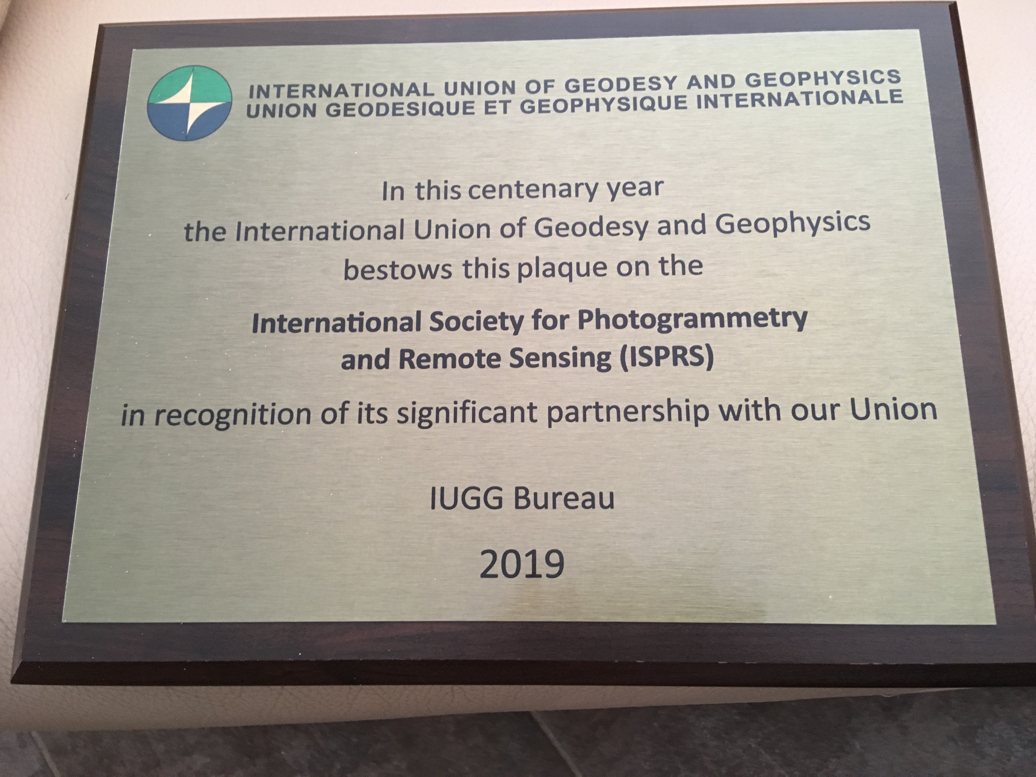
ISPRS awarded at the International Union of Geodesy and Geophysics Centenary
bar

Many of the societies ISPRS works with have a long history. One of them, the International Union of Geodesy and Geophysics (IUGG), celebrated its centenary in Paris on July 28, 2019.

IUGG awarded several societies in recognition of long and efficient co-operation. ISPRS was one of awardees and the Secretary General, Lena Halounová received a plaque, on behalf of ISPRS.

Read more here…


↑ Up


General Announcements

Carl Pulfrich Award 2019      

Carl Pulfrich Award 2019
bar

Although the Carl Pulfrich Award is not an ISPRS award – it is sponsored by Leica Geosystems, part of Hexagon - it is renowned in the geospatial world. During the 57th Photogrammetric Week in Stuttgart, Dr. Hartmut Rosengarten of Leica Geosystems, deputizing for division president Jürgen Dold, presented the Carl Pulfrich Award to Professor Bisheng Yang of Wuhan University for outstanding contribution in the field of point cloud processing. This is reported in full at https://lidarmag.com/2019/09/11/carl-pulfrich-award-2019-presented-to-prof-dr-bisheng-yang/.


↑ Up


Announcements of Scientific Meetings                (see also ISPRS Calendar)

12th AOGEO Symposium      

12th AOGEO Symposium

bar

Scaling up successful Earth observation activities for all of Asia-Oceania:
Share the results and design the future steps for three priority engagement areas
Canberra, Australia
2 - 4 November 2019

http://www.earthobservations.org/geoweekl9.php?t=aogeo

Please feel free to contact the Symposium Secretariat with any questions:
E-mail: aogeo-symposium@,geosec.org


BIM Technologies in Urban Land Management and Development using Remote Sensing, Photogrammetry and Laser Scanning Data: Managerial, Engineering and Educational Aspects

Dhulikhel, Nepal
10-11 Dec 2019

https://www.lmtc.gov.np/workshop/


Geomakani      

4th Geospatial Technologies Conference - Essential Standards for Spatial Data Infrastructure

Cairo, Egypt
17-18 Dec 2019
bar

https://www.geomakani.com/


COSPAR 2020      

COSPAR 2020
43rd Scientific Assembly of the Committee on Space Research (COSPAR) and Associated Events

Sydney, Australia
15 – 22 August 2020
bar

Contact:
COSPAR Secretariat
Tel: +33 1 44 76 75 10
cospar@cosparhq.cnes.fr
http://www.cospar-assembly.org or http://www.cospar2020.org/

Abstract Deadline: 14 February 2020


EuroSDR      

PCP 2019
2nd International Workshop Point Cloud Processing

Stuttgart, Germany
4 – 5 December 2019
bar

Focus is on the automatic interpretation of area covering point clouds including tasks like object detection and classification or object-dependent filtering and smoothing. Topics further include the collection and analysis of area covering 3D point clouds from aerial and mobile mapping platforms. The EuroSDR meeting will bring together experts from industry, academia and national mapping agencies to present and discuss the processing and evaluation of point clouds focusing on mapping purposes especially in view of the recent developments in the field of pattern recognition and machine learning.

The program will provide a mix of invited speakers from industry, academia and governmental organizations as well as presentations selected on an abstract based review process. Prospective presenters may send a 1000 word abstract to pcp2019@ifp.uni-stuttgart.de before October 7th

Further information on the workshop including registration, venue and program updates is available at http://pcp2019.ifp.uni-stuttgart.de/


Event Reports

PSBB19      

Report on ISPRS International workshop
Photogrammetric techniques for video surveillance, biometrics and biomedicine - PSBB19

Moscow, Russia
13-15 May, 2019
bar

Read the report here… 


Report on the ISPRS Geospatial Week 2019

by Sheryl Rose Reyes and Charmaine Cruz
bar

Read the report here… 


The ISPRS Geospatial Week 2019 Students and Young Professionals Night

by Charmaine Cruz and Sheryl Rose Reyes
bar

Read the report here… 


Gi4DM Conference 2019 Report

Prague, Czech Republic
4-6 September, 2019
bar

Read the report here… 


ISPRS International Journal of Geo-Information — Open Access Journal

ISPRS International Journal of Geo-Information — Open Access Journal      

New publications in the ISPRS International Journal of Geo-Information
Open Access Journal
Volume 8, Issue 7 (July 2019)

High-Performance Overlay Analysis of Massive Geographic Polygons That Considers Shape Complexity in a Cloud Environment
Zhao, Kang, Jin, Baoxuan, Fan, Hong, Song, Weiwei, Zhou, Sunyu, Jiang, Yuanyi
No: 290

Evaluating the Suitability of Urban Expansion Based on the Logic Minimum Cumulative Resistance Model: A Case Study from Leshan, China
Wang, Haijun, Peng, Peihao, Kong, Xiangdong, Zhang, Tingbin, Yi, Guihua
No: 291

The Role of African Emerging Space Agencies in Earth Observation Capacity Building for Facilitating the Implementation and Monitoring of the African Development Agenda: The Case of African Earth Observation Program
Kganyago, Mahlatse, Mhangara, Paidamwoyo
No: 292

Automatic Discovery of Railway Train Driving Modes Using Unsupervised Deep Learning
Zheng, Han, Cui, Zanyang, Zhang, Xingchen
No: 294

Automatic (Tactile) Map Generation—A Systematic Literature Review
Wabiński, Jakub, Mościcka, Albina
No: 293

Predicting the Upcoming Services of Vacant Taxis near Fixed Locations Using Taxi Trajectories
Hu, Chunchun, Thill, Jean-Claude
No: 295

Application of Remote Sensing to the Investigation of Rock Slopes: Experience Gained and Lessons Learned
Stead, Doug, Donati, Davide, Wolter, Andrea, Sturzenegger, Matthieu
No: 296

A GIS-Based Support Vector Machine Model for Flash Flood Vulnerability Assessment and Mapping in China
Xiong, Junnan, Li, Jin, Cheng, Weiming, Wang, Nan, Guo, Liang
No: 297

City Maker: Reconstruction of Cities from OpenStreetMap Data for Environmental Visualization and Simulations
Hadimlioglu, I. Alihan, King, Scott A.
No: 298

Collision Detection for UAVs Based on GeoSOT-3D Grids
Zhai, Weixin, Tong, Xiaochong, Miao, Shuangxi, Cheng, Chengqi, Ren, Fuhu
No: 299

A Convolutional Neural Network Architecture for Auto-Detection of Landslide Photographs to Assess Citizen Science and Volunteered Geographic Information Data Quality
Can, Recep, Kocaman, Sultan, Gokceoglu, Candan
No: 300

HBIM Modeling from the Surface Mesh and Its Extended Capability of Knowledge Representation
Yang, Xiucheng, Lu, Yi-Chou, Murtiyoso, Arnadi, Koehl, Mathieu, Grussenmeyer, Pierre
No: 301

Areal Interpolation Using Parcel and Census Data in Highly Developed Urban Environments
Liu, XiaoHang, Martinez, Alexis
No: 302

Skeleton Line Extraction Method in Areas with Dense Junctions Considering Stroke Features
Li, Chengming, Yin, Yong, Wu, Pengda, Wu, Wei
No: 303

A New Algorithms of Stroke Generation Considering Geometric and Structural Properties of Road Network
Liu, Yi, Li, Wenjing
No: 304

Assessing Spatial Information Themes in the Spatial Information Infrastructure for Participatory Urban Planning Monitoring: Indonesian Cities
Indrajit, Agung, Van Loenen, Bastiaan, Van Oosterom, Peter
No: 305

Modeling the Vagueness of Areal Geographic Objects: A Categorization System
Liu, Yu, Yuan, Yihong, Gao, Song
No: 306

Monitoring Ground Instabilities Using SAR Satellite Data: A Practical Approach
Del Soldato, Matteo, Solari, Lorenzo, Raspini, Federico, Bianchini, Silvia, Ciampalini, Andrea, Montalti, Roberto, Ferretti, Alessandro, Pellegrineschi, Vania, Casagli, Nicola
No: 307

Anomalous Urban Mobility Pattern Detection Based on GPS Trajectories and POI Data
Xu, Zhenzhou, Cui, Ge, Zhong, Ming, Wang, Xin
No: 308

VS30 Seismic Microzoning Based on a Geomorphology Map: Experimental Case Study of Chiang Mai, Chiang Rai, and Lamphun, Thailand
Thamarux, Patcharavadee, Matsuoka, Masashi, Poovarodom, Nakhorn, Iwahashi, Junko
No: 309

Assessment and Benchmarking of Spatially Enabled RDF Stores for the Next Generation of Spatial Data Infrastructure
Huang, Weiming, Raza, Syed Amir, Mirzov, Oleg, Harrie, Lars
No: 310

COMET’s Education and Training for the Worldwide Meteorological Satellite User Community: Meeting Evolving Needs with Innovative Instruction
Dills, Patrick, Stevermer, Amy, Mancus, Tony, Guarente, Bryan, Alberta, Tim, Page, Elizabeth
No: 311

Identifying Alternative Wetting and Drying (AWD) Adoption in the Vietnamese Mekong River Delta: A Change Detection Approach
Lovell, Robin J.
No: 312

An Agent-based Model Simulation of Human Mobility Based on Mobile Phone Data: How Commuting Relates to Congestion
Wu, Hao, Liu, Lingbo, Yu, Yang, Peng, Zhenghong, Jiao, Hongzan, Niu, Qiang
No: 313

Regionalization Analysis and Mapping for the Source and Sink of Tourist Flows
Gu, Qiushi, Zhang, Haiping, Chen, Min, Chen, Chongcheng
No: 314

Efficiency of Extreme Gradient Boosting for Imbalanced Land Cover Classification Using an Extended Margin and Disagreement Performance
Sun, Fei, Wang, Run, Wan, Bo, Su, Yanjun, Guo, Qinghua, Huang, Youxin, Wu, Xincai
No: 315

↑ Up

bar

New publications in the ISPRS International Journal of Geo-Information
Open Access Journal
Volume 8, Issue 8 (August 2019)

Multi-Criteria High Voltage Power Line Routing—An Open Source GIS-Based Approach
Zipf, Michael, Kumar, Samarth, Scharf, Hendrik, Zöphel, Christoph, Dierstein, Constantin, Möst, Dominik
No: 316

Visualizations Out of Context: Addressing Pitfalls of Real-Time Realistic Hazard Visualizations
Stempel, Peter, Becker, Austin
No: 318

The Suitability of UAS for Mass Movement Monitoring Caused by Torrential Rainfall—A Study on the Talus Cones in the Alpine Terrain in High Tatras, Slovakia
Urban, Rudolf, Štroner, Martin, Blistan, Peter, Kovanič, Ľudovít, Patera, Matej, Jacko, Stanislav, Ďuriška, Igor, Kelemen, Miroslav, Szabo, Stanislav
No: 317

Internet GIS-Based Multimodal Public Transport Trip Planning Information System for Travelers in Lithuania
Jakimavičius, Marius, Palevičius, Vytautas, Antuchevičiene, Jurgita, Karpavičius, Tomas
No: 319

Geo-Referencing and Mapping 1901 Census Addresses for England and Wales
Lan, Tian, Longley, Paul
No: 320

Multi-Aspect Analysis of Object-Oriented Landslide Detection Based on an Extended Set of LiDAR-Derived Terrain Features
Pawłuszek, Kamila, Marczak, Sylwia, Borkowski, Andrzej, Tarolli, Paolo
No: 321

Data-driven Bicycle Network Analysis Based on Traditional Counting Methods and GPS Traces from Smartphone
Rupi, Federico, Poliziani, Cristian, Schweizer, Joerg
No: 322

Research on the Spatial Features of the E-RetailingEconomic Linkages at County Level: A Case Study for Zhejiang Province, China
Shen, Wei, Qin, Yaochen, Xie, Zhixiang
No: 324

SfM-MVS Photogrammetry for Rockfall Analysis and Hazard Assessment Along the Ancient Roman Via Flaminia Road at the Furlo Gorge (Italy)
Vanneschi, Claudio, Di Camillo, Marco, Aiello, Eros, Bonciani, Filippo, Salvini, Riccardo
No: 325

Effects of Free-Floating Shared Bicycles on Urban Public Transportation
Cao, Min, Ma, Shangjing, Huang, Mengxue, Lü, Guonian, Chen, Min
No: 323

Decomposition of Repulsive Clusters in Complex Point Processes with Heterogeneous Components
Song, Ci, Pei, Tao
No: 326

Spatial Disaggregation of Historical Census Data Leveraging Multiple Sources of Ancillary Information
Monteiro, João, Martins, Bruno, Murrieta-Flores, Patricia, Pires, João M.
No: 327

Effects of Seismogenic Faults on the Predictive Mapping of Probability to Earthquake-Triggered Landslides
Shao, Xiaoyi, Xu, Chong, Ma, Siyuan, Zhou, Qing
No: 328

Querying 3D Cadastral Information from BIM Models
Atazadeh, Behnam, Rajabifard, Abbas, Zhang, Yibo, Barzegar, Maryam
No: 329

Multi-Source Geo-Information Fusion in Transition: A Summer 2019 Snapshot
Jeansoulin, Robert
No: 330

An Integrated BIM–GIS Method for Planning of Water Distribution System
Zhao, Linlin, Liu, Zhansheng, Mbachu, Jasper
No: 331

Eigenvector Spatial Filtering-Based Logistic Regression for Landslide Susceptibility Assessment
Li, Huifang, Chen, Yumin, Deng, Susu, Chen, Meijie, Fang, Tao, Tan, Huangyuan
No: 332

Development of an Indoor Space Semantic Model and Its Implementation as an IndoorGML Extension
Maheshwari, Nishith, Srivastava, Srishti, Rajan, Krishnan Sundara
No: 333

Fleet Size and Rebalancing Analysis of Dockless Bike-Sharing Stations Based on Markov Chain
Zhai, Yong, Liu, Jin, Du, Juan, Wu, Hao
No: 334

Multi-Scale Flow Field Mapping Method Based on Real-Time Feature Streamlines
Fang, Yu, Ai, Bo, Fang, Jing, Xin, Wenpeng, Zhao, Xiangwei, Lv, Guannan
No: 335

The Distribution Pattern of the Railway Network in China at the County Level
Li, Minmin, Guo, Renzhong, Li, You, He, Biao, Fan, Yong
No: 336

Guest Editor’s Editorial “Cognitive Aspects of Human-Computer Interaction for GIS”
Fritsch, Dieter
No: 337

Improving the Positional Accuracy of Traditional Cadastral Index Maps with Membrane Adjustment in Slovenia
Čeh, Marjan, Gielsdorf, Frank, Trobec, Barbara, Krivic, Mateja, Lisec, Anka
No: 338

Remote Diagnosis of Architectural Heritage Based on 5W1H Model-Based Metadata in Virtual Reality
Lee, Jongwook, Kim, Junki, Ahn, Jaehong, Woo, Woontack
No: 339

Semantic Profiles for Easing SensorML Description: Review and Proposal
Paolo, Tagliolato, Cristiano, Fugazza, Alessandro, Oggioni, Paola, Carrara
No: 340

An Improved Global Analysis of Population Distribution in Proximity to Active Volcanoes, 1975–2015
Freire, Sergio, Florczyk, Aneta J., Pesaresi, Martino, Sliuzas, Richard
No: 341

Research on Urban Ecological Network Under the Threat of Road Networks—A Case Study of Wuhan
Miao, Zuohua, Pan, Lei, Wang, Qiaozhi, Chen, Pei, Yan, Cheng, Liu, Likun
No: 342

Fused Transparent Visualization of Point Cloud Data and Background Photographic Image for Tangible Cultural Heritage Assets
Li, Liang, Hasegawa, Kyoko, Nii, Itaru, Tanaka, Satoshi
No: 343

Identify and Delimitate Urban Hotspot Areas Using a Network-Based Spatiotemporal Field Clustering Method
Xia, Zelong, Li, Hao, Chen, Yuehong, Liao, Weisheng
No: 344

A Spatio-Temporal Flow Model of Urban Dockless Shared Bikes Based on Points of Interest Clustering
Dong, Jian, Chen, Bin, He, Lingnan, Ai, Chuan, Zhang, Fang, Guo, Danhuai, Qiu, Xiaogang
No: 345

Investigating the Spatiotemporally Varying Correlation between Urban Spatial Patterns and Ecosystem Services: A Case Study of Nansihu Lake Basin, China
Li, Cheng, Zhao, Jie
No: 346

Incorporating Topological Representation in 3D City Models
Vitalis, Stelios, Arroyo Ohori, Ken, Stoter, Jantien
No: 347

Performance Testing on Marker Clustering and Heatmap Visualization Techniques: A Comparative Study on JavaScript Mapping Libraries
Netek, Rostislav, Brus, Jan, Tomecka, Ondrej
No: 348

Modeling Housing Rent in the Atlanta Metropolitan Area Using Textual Information and Deep Learning
Zhou, Xiaolu, Tong, Weitian, Li, Dongying
No: 349

Education and Training in Applied Remote Sensing in Africa: The ARCSSTE-E Experience
Agbaje, Ganiyu, Alabi, Omowumi, Offiong, Etim
No: 350

Comparison of FOSS4G Supported Equal-Area Projections Using Discrete Distortion Indicatrices
Moreira de Sousa, Luís, Poggio, Laura, Kempen, Bas
No: 351

A Study on a Matching Algorithm for Urban Underground Pipelines
Wang, Shuai, Guo, Qingsheng, Xu, Xinglin, Xie, Yuwu
No: 352

Mapping Spatiotemporal Data to RDF: A SPARQL Endpoint for Brussels
Vaisman, Alejandro, Chentout, Kevin
No: 353

Lessons Learned from the NOAA CoastWatch Ocean Satellite Course Developed for Integrating Oceanographic Satellite Data into Operational Use
Wilson, Cara, Robinson, Dale H.
No: 354

An Attention-Based Spatiotemporal Gated Recurrent Unit Network for Point-of-Interest Recommendation
Liu, Chunyang, Liu, Jiping, Wang, Jian, Xu, Shenghua, Han, Houzeng, Chen, Yang
No: 355

Geospatial Disaggregation of Population Data in Supporting SDG Assessments: A Case Study from Deqing County, China
Qiu, Yue, Zhao, Xuesheng, Fan, Deqin, Li, Songnian
No: 356

Planning Sustainable Economic Development in the Russian Arctic
Evseev, Alexander, Krasovskaya, Tatiana, Tikunov, Vladimir, Tikunova, Irina
No: 357

Assessing the Intensity of the Population Affected by a Complex Natural Disaster Using Social Media Data
Cheng, Changxiu, Zhang, Ting, Su, Kai, Gao, Peichao, Shen, Shi
No: 358

Spatiotemporal Change Analysis of Earthquake Emergency Information Based on Microblog Data: A Case Study of the “8.8” Jiuzhaigou Earthquake
Xing, Ziyao, Su, Xiaohui, Liu, Junming, Su, Wei, Zhang, Xiaodong
No: 359

Multifaceted Geometric Assessment towards Simplified Urban Surfaces Built by 3D Reconstruction
Liu, Sheng’en, Yi, Hui, Chen, Xiangning, Wang, Decheng, Jin, Wei
No: 360

Utilizing A Game Engine for Interactive 3D Topographic Data Visualization
Laksono, Dany, Aditya, Trias
No: 361

Expressing History through a Geo-Spatial Ontology
Southall, Humphrey, Aucott, Paula
No: 362

User Evaluation of Map-Based Visual Analytic Tools
Popelka, Stanislav, Herman, Lukáš, Řezník, Tomas, Pařilová, Michaela, Jedlička, Karel, Bouchal, Jiří, Kepka, Michal, Charvát, Karel
No: 363

↑ Up


ISPRS Journal of Photogrammetry and Remote Sensing

ISPRS Journal of Photogrammetry and Remote Sensing      

New publications in the ISPRS Journal of Photogrammetry and Remote Sensing Volume 155 (September 2019)

Lever-arm and boresight correction, and field of view determination of a spectroradiometer mounted on an unmanned aircraft system
Deepak Gautam, Arko Lucieer, Christopher Watson, Colin McCoull
Pages: 25-36

Unmanned Aerial System multispectral mapping for low and variable solar irradiance conditions: Potential of tensor decomposition
Sheng Wang, Andreas Baum, Pablo J. Zarco-Tejada, Carsten Dam-Hansen, Anders Thorseth, Peter Bauer-Gottwein, Filippo Bandini, Monica Garcia
Pages: 58-71

Water productivity assessments for dwarf coconut by using Landsat 8 images and agrometeorological data
A.H. de C. Teixeira, F.R. de Miranda, J.F. Leivas, E.P. Pacheco, E.A.M. Garçon
Pages: 150-158

Modelling discontinuous terrain from DSMs using segment labelling, outlier removal and thin-plate splines
Kassel Liam Hingee, Peter Caccetta, Louis Caccetta
Pages: 159-171

Mapping irrigated cropland extent across the conterminous United States at 30 m resolution using a semi-automatic training approach on Google Earth Engine
Yanhua Xie, Tyler J. Lark, Jesslyn F. Brown, Holly K. Gibbs
Pages: 136-149

Editorial Board

Pages: ii

Per-point processing for detailed urban solar estimation with aerial laser scanning and distributed computing
Anh Vu Vo, Debra F. Laefer, Aljosa Smolic, S.M. Iman Zolanvari
Pages: 119-135

Nomination-favoured opinion pool for optical-SAR-synergistic rice mapping in face of weakened flooding signals
Yiqing Guo, Xiuping Jia, David Paull, Jón Atli Benediktsson
Pages: 187-205

Development and evaluation of a deep learning model for real-time ground vehicle semantic segmentation from UAV-based thermal infrared imagery
Mehdi Khoshboresh Masouleh, Reza Shah-Hosseini
Pages: 172-186

A tentative test for measuring the sub-millimeter settlement and uplift of a high-speed railway bridge using COSMO-SkyMed images
Peifeng Ma, Tao Li, Chaoyang Fang, Hui Lin
Pages: 1-12

A robust method for reconstructing global MODIS EVI time series on the Google Earth Engine
Dongdong Kong, Yongqiang Zhang, Xihui Gu, Dagang Wang
Pages: 13-24

Semi-supervised center-based discriminative adversarial learning for cross-domain scene-level land-cover classification of aerial images
Ruixi Zhu, Li Yan, Nan Mo, Yi Liu
Pages: 72-89

HPM-TDP: An efficient hierarchical PatchMatch depth estimation approach using tree dynamic programming
Mao Tian, Bisheng Yang, Chi Chen, Ronggang Huang, Liang Huo
Pages: 37-57

Addressing overfitting on point cloud classification using Atrous XCRF
Hasan Asy’ari Arief, Ulf Geir Indahl, Geir-Harald Strand, Håvard Tveite
Pages: 90-101

Burn severity analysis in Mediterranean forests using maximum entropy model trained with EO-1 Hyperion and LiDAR data
Alfonso Fernandez-Manso, Carmen Quintano, Dar A. Roberts
Pages: 102-118

bar

New publications in the ISPRS Journal of Photogrammetry and Remote Sensing Volume 152 (June 2019)

Estimating forest stand density and structure using Bayesian individual tree detection, stochastic geometry, and distribution matching
Kasper Kansanen, Jari Vauhkonen, Timo Lähivaara, Aku Seppänen, Matti Maltamo, Lauri Mehtätalo
Pages: 66-78

Normalization of the temporal effect on the MODIS land surface temperature product using random forest regression
Wei Zhao, Hua Wu, Gaofei Yin, Si-Bo Duan
Pages: 109-118

Data extraction from digital repeat photography using xROI: An interactive framework to facilitate the process
Bijan Seyednasrollah, Thomas Milliman, Andrew D. Richardson
Pages: 132-144

Investigating the effects of 3D urban morphology on the surface urban heat island effect in urban functional zones by using high-resolution remote sensing data: A case study of Wuhan, Central China
Xin Huang, Ying Wang
Pages: 119-131

Meta-analysis of deep neural networks in remote sensing: A comparative study of mono-temporal classification to support vector machines
Shahriar S. Heydari, Giorgos Mountrakis
Pages: 192-210

A new stochastic simulation algorithm for image-based classification: Feature-space indicator simulation
Qing Wang, Hua Sun, Ruopu Li, Guangxing Wang
Pages: 145-165

Editorial Board

Pages: ii

Spatial, temporal, and spectral variations in albedo due to vegetation changes in China’s grasslands
Lei Zheng, Guosong Zhao, Jinwei Dong, Quansheng Ge, Jian Tao, Xuezhen Zhang, Youcun Qi, Russell B. Doughty, Xiangming Xiao
Pages: 1-12

Scale invariant line-based co-registration of multimodal aerial data using L1 minimization of spatial and angular deviations
Przemyslaw Polewski, Wei Yao
Pages: 79-93

An improved algorithm for estimating the Secchi disk depth from remote sensing data based on the new underwater visibility theory
Dalin Jiang, Bunkei Matsushita, Fajar Setiawan, Augusto Vundo
Pages: 13-23

The U. V. Helava Award – Best Paper Volumes 135-146 (2018)

Pages: 65

A novel framework to detect conventional tillage and no-tillage cropping system effect on cotton growth and development using multi-temporal UAS data
Akash Ashapure, Jinha Jung, Junho Yeom, Anjin Chang, Murilo Maeda, Andrea Maeda, Juan Landivar
Pages: 49-64

Automatic land-water classification using multispectral airborne LiDAR data for near-shore and river environments
Ahmed Shaker, Wai Yeung Yan, Paul E. LaRocque
Pages: 94-108

Remote sensing image fusion via compressive sensing
Morteza Ghahremani, Yonghuai Liu, Peter Yuen, Ardhendu Behera
Pages: 34-48

Characterization and modeling of power line corridor elements from LiDAR point clouds
Sebastián Ortega, Agustín Trujillo, José Miguel Santana, José Pablo Suárez, Jaisiel Santana
Pages: 24-33

Urban flood mapping with an active self-learning convolutional neural network based on TerraSAR-X intensity and interferometric coherence
Yu Li, Sandro Martinis, Marc Wieland
Pages: 178-191

Deep learning in remote sensing applications: A meta-analysis and review
Lei Ma, Yu Liu, Xueliang Zhang, Yuanxin Ye, Gaofei Yin, Brian Alan Johnson
Pages: 166-177

bar

New publications in the ISPRS Journal of Photogrammetry and Remote Sensing Volume 156 (October 2019)

Spatial-spectral local discriminant projection for dimensionality reduction of hyperspectral image
Hong Huang, Yule Duan, Haibo He, Guangyao Shi, Fulin Luo
Pages: 77-93

Landslides detection through optimized hot spot analysis on persistent scatterers and distributed scatterers
Ping Lu, Shibiao Bai, Veronica Tofani, Nicola Casagli
Pages: 147-159

Efficient and robust large-scale structure-from-motion via track selection and camera prioritization
Hainan Cui, Shuhan Shen, Wei Gao, Hongmin Liu, Zhiheng Wang
Pages: 202-214

Comparison of surface and canopy urban heat islands within megacities of eastern China
Yonghong Hu, Meiting Hou, Gensuo Jia, Chunlei Zhao, Xiaoju Zhen, Yanhua Xu
Pages: 160-168

Editorial Board

Pages: ii

Recovery of urban 3D road boundary via multi-source data
Chenglu Wen, Changbin You, Hai Wu, Cheng Wang, Xiaoliang Fan, Jonathan Li
Pages: 184-201

Bundle adjustment of satellite images based on an equivalent geometric sensor model with digital elevation model
Hui Cao, Pengjie Tao, Haihong Li, Jun Shi
Pages: 169-183

An enhanced bloom index for quantifying floral phenology using multi-scale remote sensing observations
Bin Chen, Yufang Jin, Patrick Brown
Pages: 108-120

TreeUNet: Adaptive Tree convolutional neural networks for subdecimeter aerial image segmentation
Kai Yue, Lei Yang, Ruirui Li, Wei Hu, Fan Zhang, Wei Li
Pages: 1-13

Random cross-observation intensity consistency method for large-scale SAR images mosaics: An example of Gaofen-3 SAR images covering China
Guo Zhang, Hao Cui, Taoyang Wang, Zhijiang Li, Boyang Jiang, Xin Li, Huabin Wang, Yu Zhu
Pages: 215-234

An adaptive machine learning approach to improve automatic iceberg detection from SAR images
Mauro M. Barbat, Christine Wesche, Adriano V. Werhli, Mauricio M. Mata
Pages: 247-259

Mapping dead forest cover using a deep convolutional neural network and digital aerial photography
Jean-Daniel Sylvain, Guillaume Drolet, Nicolas Brown
Pages: 14-26

Multiple-view geospatial comparison using web-based virtual globes
Liangfeng Zhu, Xinlan Chen, Zhiwen Li
Pages: 235-246

Evaluation of the MODIS collections 5 and 6 for change analysis of vegetation and land surface temperature dynamics in North and South America
Ethan Heck, Kirsten M. de Beurs, Braden C. Owsley, Geoffrey M. Henebry
Pages: 121-134

Parameters determination and sensor correction method based on virtual CMOS with distortion for the GaoFen6 WFV camera
Mi Wang, Yufeng Cheng, Beibei Guo, Shuying Jin
Pages: 51-62

Automatic canola mapping using time series of sentinel 2 images
Davoud Ashourloo, Hamid Salehi Shahrabi, Mohsen Azadbakht, Hossein Aghighi, Hamed Nematollahi, Abbas Alimohammadi, Ali Akbar Matkan
Pages: 63-76

Multi-sensor prediction of Eucalyptus stand volume: A support vector approach
Guilherme Silverio Aquino de Souza, Vicente Paulo Soares, Helio Garcia Leite, José Marinaldo Gleriani, Cibele Hummel do Amaral, Antônio Santana Ferraz, Marcus Vinicius de Freitas Silveira, Flávio Costa dos Santos, Sidney Geraldo Silveira Velloso, Getulio Fonseca Domingues, Simone Silva
Pages: 135-146

A bridge-tailored multi-temporal DInSAR approach for remote exploration of deformation characteristics and mechanisms of complexly structured bridges
Xiaoqiong Qin, Xiaoli Ding, Mingsheng Liao, Lu Zhang, Chisheng Wang
Pages: 27-50

Automated fusion of forest airborne and terrestrial point clouds through canopy density analysis
Wenxia Dai, Bisheng Yang, Xinlian Liang, Zhen Dong, Ronggang Huang, Yunsheng Wang, Wuyan Li
Pages: 94-107

bar

↑ Up


New Events

02-03 Oct 2019
Fourth International Conference on Smart Data and Smart Cities
https://www.geoinfo.utm.my/sdsc2019/
Kuala Lumpur, Malaysia
 

03-05 Oct 2019
International Conference on Smart Data, Smart Cities, Smart Governance
http://smartcities-cept.in/
Ahmedabad, India
 

10-11 Oct 2019
Workshop on Researches, Results and Reviews in Geomatics
http://www.r3geomatics.uniparthenope.it/
Naples, Italy
 

02-04 Nov 2019
12th AOGEO Symposium
http://www.earthobservations.org/geoweekl9.php?t=aogeo
Canberra, Australia
 

13-14 Nov 2019
UPINLBS
The Sixth International Ubiquitous Positioning, Indoor Navigation and Location-Based Services conference, 2019
http://kmap.ckcest.cn/upinlbs2019/index.html
Beijing, China
 

20 Nov 2019
PSIVT2019
Workshop on Passive and Active Electro-Optical Sensors for Aerial & Space Imaging
http://www2.informatik.hu-berlin.de/cv/psivt2019/
Sydney, Australia
 

20-22 Nov 2019
Capacity Building and Education in Geospatial Technology
https://cept.ac.in/CAG
Meghalaya, India
 

26 Nov 2019
ACPR2019
Towards an Automatic Data Processing Chain for Airborne and Spaceborne Sensors
http://www2.informatik.hu-berlin.de/cv/acpr2019/
Auckland, New Zealand
 

04-05 Dec 2019
PCP 2019
2nd International Workshop Point Cloud Processing
http://pcp2019.ifp.uni-stuttgart.de
Stuttgart, Germany
 

04-06 Dec 2019
5th International Conference MetroArcheo 2018
Metrology for Archaeology and Cultural Heritage
http://www.metroarcheo.com/home
Florence, Italy
 

10-11 Dec 2019
International Workshop on
Capacity Building and Education Outreach in Advance Geospatial Technologies and Land Management
Special Session on
BIM Technologies in Urban Land Management and Development using Remote Sensing, Photogrammetry and Laser Scanning Data: Managerial, Engineering and Educational Aspects
https://www.lmtc.gov.np/workshop/
Dhulikhel, Nepal
 

13-14 Dec 2019
National Symposium on Industry Academia Collaboration fpr Geospatial Technology - 2019
https://cept.ac.in/CAG
Ahmedabad, India
 

17-18 Dec 2019
ISEDH-2019
International Symposium on Environmental, Disaster and Health
http://idmvs.edu.bd/symposium/index.html
Dhaka, Bangladesch
 

17-18 Dec 2019
4th Geospatial Technologies Conference
Essential Standards for Spatial Data Infrastructure
http://www.geomakani.com
Cairo, Egypt
 

18-20 Mar 2020
GIS Ostrava 2020
UAV in Smart City and Smart Region
http://gis.vsb.cz/gisostrava/
Ostrava, Czech Republic
 

20-22 Apr 2020
SpaceTimeAI 2020
First International Symposium on Spatio-Temporal Artificial Intelligence
https://www.ucl.ac.uk/civil-environmental-geomatic-engineering/
London, UK
 

03-05 Jun 2020
27th International Conference on Systems, Signals and Image Processing IWSSIP 2020
http://iwssip2020.ic.uff.br/
Niteroi – Rio de Janeiro, Brasil
 

07-10 Jul 2020
GI_Forum Symposium | Exhibit
connecting spatially
http://www.gi-forum.org/
Salzburg, Austria
 

15-22 Aug 2020
COSPAR 2020
43rd Scientific Assembly of the Committee on Space Research (COSPAR) and Associated Events
http://www.cospar2020.org/
Sydney, Australia
 

26-28 May 2021
The 12th International Conference on Mobile Mapping Technology
website not yet available
Padua, Italy
 

» See more


Job Opportunities

3-Sep-2019 Photogrammetrist (GS-11/12 Physical Scientist)
Astrogeology Science Center, U. S. Geological Survey, Flagstaff, Arizona, USA
Deadline: 23-Sep-2019
11-Sep-2019 PhD Candidate “Fusion of Earth Observation Data with Geo-Information for Water Sensitive Cities in India”
Department Earth Observation Science (EOS), Faculty ITC, University of Twente
Deadline: 7-Oct-2019

» See more


You got this email as you subscribed to the ISPRS mailing list.
Officers, members and contact persons of members get it by default.
 
To unsubscribe from the ISPRS mailing list, click here.
© ISPRS, 2019.
Imprint