
ISPRS announces Awards to be presented at the XXV ISPRS Congress in Toronto
Wholehearted congratulations to all awardees on their outstanding success!
ISPRS Council thanks all nominators, jury members and others involved in selecting the awardees. More information on ISPRS awards can be found at https://www.isprs.org/society/awards.aspx.
» Read more details

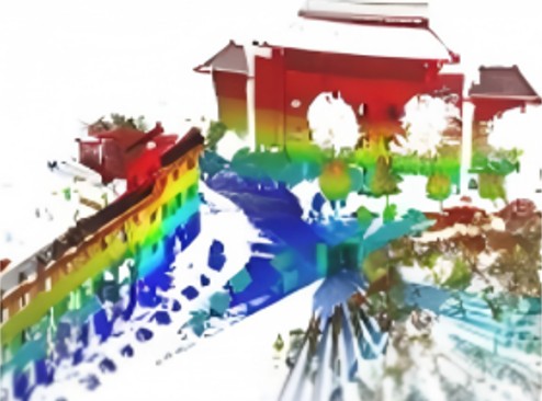
A New Benchmark for Large-Scale Aerial-Ground Image-to-Point cloud localization: AGI2P
Accurate visual localization in dense urban environments constitutes a fundamental task in photogrammetry, geospatial information science, and robotics. While imagery is a low-cost and widely accessible sensing modality, its effectiveness on visual odometry is often limited by textureless surfaces, severe viewpoint changes, and long-term drift. The growing public availability of airborne laser scanning (ALS) data opens new avenues for scalable and precise visual localization by leveraging ALS as a prior map.
Read more »

Announcement on CATCON 9: Call for Initial Evaluation Submissions
Computer Assisted Teaching Contest (CATCON)
What is CATCON?
CATCON is the name of a software contest organized by ISPRS. The main objective of the contest is to promote the development and dissemination of effective and user-friendly, open-source and preferably non-commercial software.
When is CATCON?
The competition will take place during the ISPRS Congress in Toronto. Day and time to be determined and communicated later with the final program of the congress.
Who can participate?
Any participant registered and admitted for an ISPRS Congress can submit a proposal and preliminary work for CATCON. The contest is open to individuals and teams. Each group can only submit one proposal. Software, which was presented at one Congress, can only be presented again at another Congress after having undergone substantial changes.
What is the prize?
There are three prizes: Gold award (3.000,- SFr.), a Silver Award (2.500,- SFr.) and a Bronze Award (1.500,- SFr.) and a certificate. Sponsored by The ISPRS Foundation.
» Read more details

The U. V. Helava Award – Best Paper 2025 announced
Congratulations go to Tao Sunb, Yan Hao, Shengyu Huang, Silvio Savarese, Konrad Schindler, Marc Pollefeys and Iro Armeni for their paper Nothing Stands Still: A spatiotemporal benchmark on 3D point cloud registration under large geometric and temporal change which was chosen as the 2025 Best Paper for the current evaluation period. The paper was published ISPRS Journal of Photogrammetry and Remote Sensing, Volume 220, February 2025, Pages 799-823. https://doi.org/10.1016/j.isprsjprs.2025.01.010
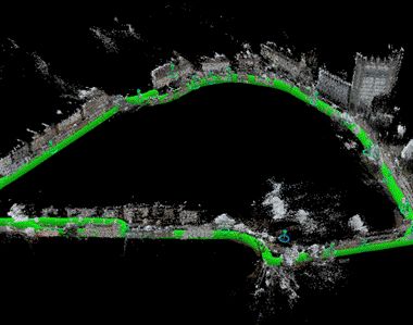
A New Benchmark for Large-Scale Point Cloud Registration: WHU-TLS
Registering large-scale point clouds is fundamental for applications ranging from 3D modeling and robotics to forestry and heritage conservation. Yet, existing datasets often face key issues: they either lack the scale and environmental diversity needed for real-world scenarios, or they do not provide sufficient variations in overlap, point density, and clutter. WHU-TLS overcomes these limitations by providing a massive, highly diverse collection of Terrestrial Laser Scanning (TLS) point clouds across varied environments, paired with reliable ground-truth transformations for precise algorithm evaluation.
Read more »

Jack Dangermond Award - Best Paper 2025
The winners of Jack Dangermond Best Paper Award 2025 are Mañago, C.A.R.; Nasalita, M.G.; Saveron, C.V.; Sunga, Y.A.D.; Claridades, A.R.C. for their paper:
Development of a Fifteen-Minute City Index Using Walkability Scores and Age-Classified Population: The Case of Pasig City, Metro Manila, Philippines. ISPRS Int. J. Geo-Inf. 2025, 14, 78.
https://doi.org/10.3390/ijgi14020078

Webinar Series by ISPRS WG III/9
Environmental & Health Concerns: Geospatial Technology
ISPRS WG III/9 (Geospatial Environment and Health Analytics) Webinar
Speaker: Dr. Pinliang Dong
Topic: LiDAR Applications in Urban Environmental Studies
Date/Time: February 25, 2026, 2 PM, GMT (Greenwich Mean Time)
» Read more details

Early Registration Discount– Only 2 Weeks Left!
Join the global geospatial community at the XXV ISPRS Congress 2026
📍 Toronto, Canada | 🗓 4–11 July 2026
Register now and enjoy early registration discounted fees!
Why register early?
• Save with special early registration pricing
• Plan ahead, get your visa, and book your conference travel
• Access a world-class program: plenaries, technical sessions, workshops & industry talks
• Expand your international network of researchers, professionals & decision-makers
📌 Two weeks. One decision. Countless opportunities.
👉 Register now and save: https://isprs2026.org/puzf

The 2026 International Student Competition on Digital Architectural Design
Klang, Malaysia| Final Presentation & Award Ceremony: July 2026| Work Exhibition: November 2026
The 2026 International Student Competition on Digital Architectural Design invites undergraduate and graduate students worldwide to explore innovative digital and architectural solutions for urban regeneration in Bandar Baru Klang.
Theme: Think Beyond the City — Reimagine Klang’s Future
• Open to undergraduate and graduate students worldwide
• Teams of up to 6 students with up to 2 supervisors
• Awards up to USD 8,000
• Top 10 teams will be invited to on-site final presentations in Malaysia
• Registration deadline: 15 March 2026
» Read more details
A New Dataset for Geospatial Visual Localisation: egenioussBench
Determining a camera’s pose from images – known as visual localisation- is fundamental to applications from autonomous driving and robotics to augmented reality, yet existing datasets face two key issues. They either lack the scale needed for large-scale scenes, limiting progress towards truly scalable methods. Second, when they do cover large scenes, they often provide imprecise ground truth poses for the query image data. egenioussBench overcomes these limitations by pairing a high-resolution aerial 3D mesh and a CityGML LoD2 model as geospatial referee data and a map-independent ground-level smartphone imagery with centimetre-accurate poses obtained via PPK and GCP/CP-aided adjustment as query data.
Read more »