
XXIV ISPRS Congress
Virtual Event of the 2020 Presentations
Nice, France, 31.08.2020 - 02.09.2020
Organizer: Société Française de Photogrammétrie et de Télédétection / Nicolas Paparoditis
Type of Event: Congress
Multi Media Type: Remote
Session: Catalogue
Catalogue
Single Presentations
Noise-tolerant hyperspectral image classification using Discrete Cosine Transform and Convolutional Neural Networks
Corresponding paper: NOISE-TOLERANT HYPERSPECTRAL IMAGE CLASSIFICATION USING DISCRETE COSINE TRANSFORM AND CONVOLUTIONAL NEURAL NETWORKS
Auhor(s): A. Voulodimos, K. Fokeas, N. Doulamis, A. Doulamis, and K. Makantasis
Volume: Archives XLIII-B2-2020 / 2020
https://doi.org/10.5194/isprs-archives-XLIII-B2-2020-1281-2020
3D Models of the QH31, QH32 and QH33 tombs in Qubbet el Hawa (Aswan, Egypt)
Corresponding paper: 3D MODELS OF THE QH31, QH32 AND QH33 TOMBS IN QUBBET EL HAWA (ASWAN, EGYPT)
Auhor(s): A. T. Mozas-Calvache, J. L. Pérez-García, J. M. Gómez-López, J. L. Martínez de Dios, and A. Jiménez-Serrano
Volume: Archives XLIII-B2-2020 / 2020
https://doi.org/10.5194/isprs-archives-XLIII-B2-2020-1427-2020
APPLICATION OF REMOTE SENSING AND GOOGLE EARTH ENGINE FOR MONITORING ENVIRONMENTAL DEGRADATION IN THE NILIGIR BIOSPHERE RESERVE AND ITS ECOSYSTEM OF W
Corresponding paper: APPLICATION OF REMOTE SENSING AND GOOGLE EARTH ENGINE FOR MONITORING ENVIRONMENTAL DEGRADATION IN THE NILGIRI BIOSPHERE RESERVE AND ITS ECOSYSTEM OF WESTERN GHATS, INDIA
Auhor(s): S. Abdul Rahaman and R. Venkatesh
Volume: Archives XLIII-B3-2020 / 2020
https://doi.org/10.5194/isprs-archives-XLIII-B3-2020-933-2020

From archive documentation to online 3D model visualization of no longer existing structures: the Turin 1911 project
Corresponding paper: FROM ARCHIVE DOCUMENTATION TO ONLINE 3D MODEL VISUALIZATION OF NO LONGER EXISTING STRUCTURES: THE TURIN 1911 PROJECT
Auhor(s): D. Einaudi, A. Spreafico, F. Chiabrando, and C. Della Coletta
Volume: Archives XLIII-B2-2020 / 2020
https://doi.org/10.5194/isprs-archives-XLIII-B2-2020-837-2020
Circular-shaped object detection in low resolution satellite images
Corresponding paper: CIRCULAR-SHAPED OBJECT DETECTION IN LOW RESOLUTION SATELLITE IMAGES
Auhor(s): A. Tadros, S. Drouyer, R. Grompone von Gioi, G. Facciolo, and L. Carvalho
Volume: Annals V-2-2020 / 2020
https://doi.org/10.5194/isprs-annals-V-2-2020-901-2020

Study on the application of airborne LiDAR in seismic active faults in the northern rim of Qinling Mountains and the Piedmont of Huashan in China
Corresponding paper: STUDY ON THE APPLICATION OF AIRBORNE LIDAR IN SEISMIC ACTIVE FAULTS IN THE NORTHERN RIM OF QINLING MOUNTAIN AND THE PIEDMONT OF HUASHAN IN CHINA
Auhor(s): G. He and A. Wang
Volume: Archives XLIII-B2-2020 / 2020
https://doi.org/10.5194/isprs-archives-XLIII-B2-2020-241-2020
Object based image analysis and texture features for pasture classification in Brazilian savannah
Corresponding paper: OBJECT BASED IMAGE ANALYSIS AND TEXTURE FEATURES FOR PASTURE CLASSIFICATION IN BRAZILIAN SAVANNAH
Auhor(s): C. D. Girolamo-Neto, L. Y. Sato, I. D. Sanches, I. C. O. Silva, J. C. S. Rocha, and C. A. Almeida
Volume: Annals V-3-2020 / 2020
https://doi.org/10.5194/isprs-annals-V-3-2020-453-2020
Relative radiometric normalization using several automatically chosen reference images for multi-sensor, multi-temporal series
Corresponding paper: RELATIVE RADIOMETRIC NORMALIZATION USING SEVERAL AUTOMATICALLY CHOSEN REFERENCE IMAGES FOR MULTI-SENSOR, MULTI-TEMPORAL SERIES
Auhor(s): C. Hessel, R. Grompone von Gioi, J. M. Morel, G. Facciolo, P. Arias, and C. de Franchis
Volume: Annals V-2-2020 / 2020
https://doi.org/10.5194/isprs-annals-V-2-2020-845-2020

An approach for standardization of semantic models for building renovation processes
Corresponding paper: AN APPROACH FOR STANDARDIZATION OF SEMANTIC MODELS FOR BUILDING RENOVATION PROCESSES
Auhor(s): C. Mirarchi, M. N. Lucky, S. Ciuffreda, M. Signorini, S. Lupica Spagnolo, C. Bolognesi, B. Daniotti, and A. Pavan
Volume: Archives XLIII-B4-2020 / 2020
https://doi.org/10.5194/isprs-archives-XLIII-B4-2020-69-2020

Geomatics technologies in the framework of multidisciplinary project for integrated management of cultural heritage sites
Corresponding paper: GEOMATICS TECHNOLOGIES IN THE FRAMEWORK OF MULTIDISCIPLINARY PROJECT FOR INTEGRATED MANAGEMENT OF CULTURAL HERITAGE SITES
Auhor(s): C. Moise, A.-M. Lazar, C. E. Mihalache, L. A. Dedulescu, I. F. Dana Negula, A. Badea, V. D. Poenaru, R. Moise, and A. R. Ortan
Volume: Archives XLIII-B2-2020 / 2020
https://doi.org/10.5194/isprs-archives-XLIII-B2-2020-1477-2020
SPATIO-TEMPORAL OBJECT STABILITY FOR MONITORING EVOLVING AREAS IN SATELLITE IMAGE TIME SERIES
Corresponding paper: SPATIO-TEMPORAL OBJECT STABILITY FOR MONITORING EVOLVING AREAS IN SATELLITE IMAGE TIME SERIES
Auhor(s): C. Tuna, F. Merciol, and S. Lefèvre
Volume: Archives XLIII-B2-2020 / 2020
https://doi.org/10.5194/isprs-archives-XLIII-B2-2020-1273-2020

Exploration of Municipal Mobility Using Smartphone GPS Data
Corresponding paper: EXPLORATION OF MUNICIPAL MOBILITY USING SMARTPHONE GPS DATA
Auhor(s): X. Peng, C. Wang, K. Liu, A. Quinones, S. Li, and J. Shan
Volume: Annals V-4-2020 / 2020
https://doi.org/10.5194/isprs-annals-V-4-2020-209-2020

DEFINITION OF A METHODOLOGY TO DERIVE ROAD NETWORK FUNCTIONAL HIERARCHY CLASSES USING CAR TRACKING DATA
Corresponding paper: DEFINITION OF A METHODOLOGY TO DERIVE ROAD NETWORK FUNCTIONAL HIERARCHY CLASSES USING CAR TRACKING DATA
Auhor(s): A. Ajmar, E. Arco, and P. Boccardo
Volume: Archives XLIII-B4-2020 / 2020
https://doi.org/10.5194/isprs-archives-XLIII-B4-2020-307-2020

A GIS-based multi-criteria analysis on cropland suitability in Bornuur soum, Mongolia
Corresponding paper: A GIS-BASED MULTI-CRITERIA ANALYSIS ON CROPLAND SUITABILITY IN BORNUUR SOUM, MONGOLIA
Auhor(s): E. Natsagdorj, T. Renchin, P. De Maeyer, R. Goossens, T. Van de Voorde, and B. Darkhijav
Volume: Archives XLIII-B4-2020 / 2020
https://doi.org/10.5194/isprs-archives-XLIII-B4-2020-149-2020

BUILDING ARCHAEOLOGY DOCUMENTATION AND ANALYSIS THROUGH OPEN SOURCE HBIM SOLUTIONS VIA NURBS MODELLING
Corresponding paper: BUILDING ARCHAEOLOGY DOCUMENTATION AND ANALYSIS THROUGH OPEN SOURCE HBIM SOLUTIONS VIA NURBS MODELLING
Auhor(s): F. Diara and F. Rinaudo
Volume: Archives XLIII-B2-2020 / 2020
https://doi.org/10.5194/isprs-archives-XLIII-B2-2020-1381-2020

DISIR: deep image segmentation with interactive refinement
Corresponding paper: DISIR: DEEP IMAGE SEGMENTATION WITH INTERACTIVE REFINEMENT
Auhor(s): G. Lenczner, B. Le Saux, N. Luminari, A. Chan-Hon-Tong, and G. Le Besnerais
Volume: Annals V-2-2020 / 2020
https://doi.org/10.5194/isprs-annals-V-2-2020-877-2020

Geomatic contribution for the restoration project of the Valentino Castle Green Room. From data acquisition to integrated documentation
Corresponding paper: GEOMATIC CONTRIBUTION FOR THE RESTORATION PROJECT OF THE VALENTINO CASTLE GREEN ROOM. FROM DATA ACQUISITION TO INTEGRATED DOCUMENTATION
Auhor(s): G. Patrucco, F. Chiabrando, A. Dameri, and L. Teppati Losè
Volume: Archives XLIII-B2-2020 / 2020
https://doi.org/10.5194/isprs-archives-XLIII-B2-2020-885-2020

Automation of thermal point clouds analysis for the extraction of windows and thermal bridges of building facades
Corresponding paper: AUTOMATION OF THERMAL POINT CLOUDS ANALYSIS FOR THE EXTRACTION OF WINDOWS AND THERMAL BRIDGES OF BUILDING FACADES
Auhor(s): H. Macher, T. Landes, and P. Grussenmeyer
Volume: Archives XLIII-B2-2020 / 2020
https://doi.org/10.5194/isprs-archives-XLIII-B2-2020-287-2020

Classification of UAV-based photogrammetric point clouds of riverine species using machine learning algorithms: a case study in the Palancia river, Sp
Corresponding paper: CLASSIFICATION OF UAV-BASED PHOTOGRAMMETRIC POINT CLOUDS OF RIVERINE SPECIES USING MACHINE LEARNING ALGORITHMS: A CASE STUDY IN THE PALANCIA RIVER, SPAIN
Auhor(s): J. P. Carbonell-Rivera, J. Estornell, L. A. Ruiz, J. Torralba, and P. Crespo-Peremarch
Volume: Archives XLIII-B2-2020 / 2020
https://doi.org/10.5194/isprs-archives-XLIII-B2-2020-659-2020
An automatic cloud detection method based on generative adversarial networks in remote sensing images
Corresponding paper: AUTOMATIC CLOUD DETECTION METHOD BASED ON GENERATIVE ADVERSARIAL NETWORKS IN REMOTE SENSING IMAGES
Auhor(s): J. Li, Z. Wu, Z. Hu, Y. Zhang, and M. Molinier
Volume: Annals V-2-2020 / 2020
https://doi.org/10.5194/isprs-annals-V-2-2020-885-2020
3D photogrammetric inspection of risers using RPAs and deep learning in oil and gas offshore platforms
Corresponding paper: 3D PHOTOGRAMMETRIC INSPECTION OF RISERS USING RPAS AND DEEP LEARNING IN OIL AND GAS OFFSHORE PLATFORMS
Auhor(s): J. D. Salazar, P. Buschinelli, G. Marcellino, M. Machado, H. Rodrigues, D. Regner, D. Oliveira, J. M. Santos, C. A. Marinho, M. R. Stemmer, and T. C. Pinto
Volume: Archives XLIII-B2-2020 / 2020
https://doi.org/10.5194/isprs-archives-XLIII-B2-2020-1265-2020

Updates of 'AW3D30' ALOS global digital surface model with other open access datasets
Corresponding paper: UPDATES OF ‘AW3D30’ ALOS GLOBAL DIGITAL SURFACE MODEL WITH OTHER OPEN ACCESS DATASETS
Auhor(s): J. Takaku, T. Tadono, M. Doutsu, F. Ohgushi, and H. Kai
Volume: Archives XLIII-B4-2020 / 2020
https://doi.org/10.5194/isprs-archives-XLIII-B4-2020-183-2020
City-scale taxi demand prediction using multisource urban geospatial data
Corresponding paper: CITY-SCALE TAXI DEMAND PREDICTION USING MULTISOURCE URBAN GEOSPATIAL DATA
Auhor(s): J. Yan, L. Xiang, C. Wu, and H. Wu
Volume: Archives XLIII-B4-2020 / 2020
https://doi.org/10.5194/isprs-archives-XLIII-B4-2020-213-2020
Multi-Modal Deep Learning with Sentinel-3 Observations for the Detection of Oceanic Internal Waves
Corresponding paper: MULTI-MODAL DEEP LEARNING WITH SENTINEL-3 OBSERVATIONS FOR THE DETECTION OF OCEANIC INTERNAL WAVES
Auhor(s): L. Drees, J. Kusche, and R. Roscher
Volume: Annals V-2-2020 / 2020
https://doi.org/10.5194/isprs-annals-V-2-2020-813-2020
Simulation-based data augmentation using physical priors for noise filtering deep neural network
Corresponding paper: SIMULATION-BASED DATA AUGMENTATION USING PHYSICAL PRIORS FOR NOISE FILTERING DEEP NEURAL NETWORK
Auhor(s): M. Jameela, L. Chen, A. Sit, J. Yoo, C. Verheggen, and G. Sohn
Volume: Archives XLIII-B2-2020 / 2020
https://doi.org/10.5194/isprs-archives-XLIII-B2-2020-247-2020

Superpixel segmentation for PolSAR images based on hexagon initialization and edge refinement
Corresponding paper: SUPERPIXEL SEGMENTATION FOR POLSAR IMAGES BASED ON HEXAGON INITIALIZATION AND EDGE REFINEMENT
Auhor(s): M. Li, H. Zou, Q. Ma, J. Sun, X. Cao, and X. Qin
Volume: Archives XLIII-B2-2020 / 2020
https://doi.org/10.5194/isprs-archives-XLIII-B2-2020-1225-2020
UAV IMAGES AND DEEP-LEARNING ALGORITHMS FOR DETECTING FLAVESCENCE DOREE DISEASE IN GRAPEVINE ORCHARDS
Corresponding paper: UAV IMAGES AND DEEP-LEARNING ALGORITHMS FOR DETECTING FLAVESCENCE DOREE DISEASE IN GRAPEVINE ORCHARDS
Auhor(s): M. A. Musci, C. Persello, and A. M. Lingua
Volume: Archives XLIII-B3-2020 / 2020
https://doi.org/10.5194/isprs-archives-XLIII-B3-2020-1483-2020

MOVING OBJECT CLASSIFICATION USING MULTILAYER LASER SCANNING WITH SPACE SUBDIVISION FRAMEWORK
Corresponding paper: MOVING OBJECT CLASSIFICATION USING MULTILAYER LASER SCANNING WITH SPACE SUBDIVISION FRAMEWORK
Auhor(s): M. Nakagawa and M. Taguchi
Volume: Annals V-4-2020 / 2020
https://doi.org/10.5194/isprs-annals-V-4-2020-103-2020

Policy Driven Application of Remote Sensing in Mitigating Urban Sprawl: A Case Study of Developing Nation
Corresponding paper: POLICY DRIVEN APPLICATION OF REMOTE SENSING IN MITIGATING URBAN SPRAWL: A CASE STUDY OF DEVELOPING NATION
Auhor(s): P. B. Shah and C. R. Patel
Volume: Archives XLIII-B3-2020 / 2020
https://doi.org/10.5194/isprs-archives-XLIII-B3-2020-751-2020
Remote sensing and multivariate logistic regression model for the estimation of urban expansion (case of Darkhan city, Mongolia)
Corresponding paper: REMOTE SENSING AND MULTIVARIATE LOGISTIC REGRESSION MODEL FOR THE ESTIMATION OF URBAN EXPANSION (CASE OF DARKHAN CITY, MONGOLIA)
Auhor(s): P. Myagmartseren, D. Ganpurev, I. Myagmarjav, G. Byambakhuu, and G. Dabuxile
Volume: Archives XLIII-B3-2020 / 2020
https://doi.org/10.5194/isprs-archives-XLIII-B3-2020-721-2020

Estimating built-up area change in Ulaanbaatar city, Mongolia
Corresponding paper: ESTIMATING BUILT-UP AREA CHANGE IN ULAANBAATAR CITY, MONGOLIA
Auhor(s): P. Myagmartseren, I. Myagmarjav, N. Enkhtuya, G. Byambakhuu, and T. Bazarkhand
Volume: Archives XLIII-B4-2020 / 2020
https://doi.org/10.5194/isprs-archives-XLIII-B4-2020-143-2020
A method for estimating the number of households in a region from the number of buildings estimated by deep learning with the adjustment of its number
Corresponding paper: A METHOD FOR ESTIMATING THE NUMBER OF HOUSEHOLDS IN A REGION FROM THE NUMBER OF BUILDINGS ESTIMATED BY DEEP LEARNING WITH THE ADJUSTMENT OF ITS NUMBER USING ANCILLARY DATASETS: CASE STUDY IN DJAKARTA
Auhor(s): R. Ito, K. Hara, Y. Shimazaki, N. Mori, Y. Kani, and A. Okabe
Volume: Archives XLIII-B4-2020 / 2020
https://doi.org/10.5194/isprs-archives-XLIII-B4-2020-673-2020

Plausible reconstruction of an approximated mesh model for next-best view planning of SfM-MVS
Corresponding paper: PLAUSIBLE RECONSTRUCTION OF AN APPROXIMATED MESH MODEL FOR NEXT-BEST VIEW PLANNING OF SFM-MVS
Auhor(s): R. Moritani, S. Kanai, H. Date, Y. Niina, and R. Honma
Volume: Archives XLIII-B2-2020 / 2020
https://doi.org/10.5194/isprs-archives-XLIII-B2-2020-465-2020

Using scene geometry to resect sensor models for photogrammetric analysis

Baroque banded vaults: surveying and modeling. The case study of a noble palace in Turin
Corresponding paper: BAROQUE BANDED VAULTS: SURVEYING AND MODELING. THE CASE STUDY OF A NOBLE PALACE IN TURIN
Auhor(s): M. C. López González, R. Spallone, M. Vitali, and F. Natta
Volume: Archives XLIII-B2-2020 / 2020
https://doi.org/10.5194/isprs-archives-XLIII-B2-2020-871-2020

Earth observation applications for Goal 14: Improving maritime domain awareness using synthetic aperture radar imaging with automatic identification s
Corresponding paper: EARTH OBSERVATION APPLICATIONS FOR GOAL 14: IMPROVING MARITIME DOMAIN AWARENESS USING SYNTHETIC APERTURE RADAR IMAGING WITH AUTOMATIC IDENTIFICATION SYSTEM IN THE PHILIPPINES
Auhor(s): R. Vicente, L. Tabanggay, J. Rayo, K. Mina, and A. Retamar
Volume: Archives XLIII-B3-2020 / 2020
https://doi.org/10.5194/isprs-archives-XLIII-B3-2020-215-2020
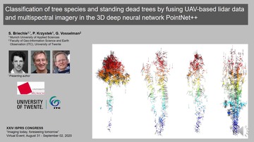
Classification of tree species and standing dead trees by fusing UAV-based lidar data and multispectral imagery in the 3D deep neural network PointNet
Corresponding paper: CLASSIFICATION OF TREE SPECIES AND STANDING DEAD TREES BY FUSING UAV-BASED LIDAR DATA AND MULTISPECTRAL IMAGERY IN THE 3D DEEP NEURAL NETWORK POINTNET++
Auhor(s): S. Briechle, P. Krzystek, and G. Vosselman
Volume: Annals V-2-2020 / 2020
https://doi.org/10.5194/isprs-annals-V-2-2020-203-2020

City-scale human mobility prediction model by integrating GNSS trajectories and SNS data using Long short-term memory
Corresponding paper: CITY-SCALE HUMAN MOBILITY PREDICTION MODEL BY INTEGRATING GNSS TRAJECTORIES AND SNS DATA USING LONG SHORT-TERM MEMORY
Auhor(s): S. Miyazawa, X. Song, R. Jiang, Z. Fan, R. Shibasaki, and T. Sato
Volume: Annals V-4-2020 / 2020
https://doi.org/10.5194/isprs-annals-V-4-2020-87-2020
Assessment of gully erosion in a catchment area in olive groves using UAS photogrammetry techniques
Corresponding paper: ANALYSIS OF GULLY EROSION IN A CATCHMENT AREA IN OLIVE GROVES USING UAS PHOTOGRAMMETRY TECHNIQUES
Auhor(s): T. Fernández, J. M. Gómez-Lopez, J. L. Pérez-García, J. Cardenal, J. Delgado, E. Mata, M. Sánchez-Gómez, J. Calero, J. Tovar-Pescador, and F. Moya
Volume: Archives XLIII-B2-2020 / 2020
https://doi.org/10.5194/isprs-archives-XLIII-B2-2020-1057-2020
Moving Objects Aware Sensor Mesh Fusion for Indoor Reconstruction from a Couple of 2D LiDAR Scans
Corresponding paper: MOVING OBJECTS AWARE SENSOR MESH FUSION FOR INDOOR RECONSTRUCTION FROM A COUPLE OF 2D LIDAR SCANS
Auhor(s): T. Wu, B. Vallet, C. Demonceaux, and J. Liu
Volume: Archives XLIII-B2-2020 / 2020
https://doi.org/10.5194/isprs-archives-XLIII-B2-2020-507-2020

Building outline delineation: from very high resolution remote sensing imagery to polygons with an improved end-to-end learning framework
Corresponding paper: BUILDING OUTLINE DELINEATION: FROM VERY HIGH RESOLUTION REMOTE SENSING IMAGERY TO POLYGONS WITH AN IMPROVED END-TO-END LEARNING FRAMEWORK
Auhor(s): W. Zhao, I. Ivanov, C. Persello, and A. Stein
Volume: Archives XLIII-B2-2020 / 2020
https://doi.org/10.5194/isprs-archives-XLIII-B2-2020-731-2020
Moving ship detection and movement prediction in remote sensing videos
Corresponding paper: MOVING SHIP DETECTION AND MOVEMENT PREDICTION IN REMOTE SENSING VIDEOS
Auhor(s): Y. Wang, H. Cheng, X. Zhou, W. Luo, and H. Zhang
Volume: Archives XLIII-B2-2020 / 2020
https://doi.org/10.5194/isprs-archives-XLIII-B2-2020-1303-2020

Binocular visual environment perception technology for unmanned surface vehicle
Corresponding paper: BINOCULAR VISUAL ENVIRONMENT PERCEPTION TECHNOLOGY FOR UNMANNED SURFACE VEHICLE
Auhor(s): Y. Wang, M. Peng, Z. Liu, W. Wan, K. Di, C. Hu, L. Liu, T. Lv, and C. Yang
Volume: Archives XLIII-B2-2020 / 2020
https://doi.org/10.5194/isprs-archives-XLIII-B2-2020-1297-2020

Completion of sparse and partial point clouds of vehicles using a novel end-to-end network
Corresponding paper: COMPLETION OF SPARSE AND PARTIAL POINT CLOUDS OF VEHICLES USING A NOVEL END-TO-END NETWORK
Auhor(s): Y. Xia, W. Liu, Z. Luo, Y. Xu, and U. Stilla
Volume: Annals V-2-2020 / 2020
https://doi.org/10.5194/isprs-annals-V-2-2020-933-2020