
XXIV ISPRS Congress
2021 Digital Edition
Nice, France, 05.07.2021 - 09.07.2021
Organizer: Société Française de Photogrammétrie et de Télédétection / Nicolas Paparoditis
Type of Event: Congress
Multi Media Type: Remote
Session: IPS.TU.2.III
Interactive Poster Session - 6th July
Single Presentations
A NOVEL PROCEDURE FOR GENERATION OF SAR-DERIVED ZTD MAPS FOR WEATHER PREDICTION: APPLICATION TO SOUTH AFRICA USE CASE
Corresponding paper: A NOVEL PROCEDURE FOR GENERATION OF SAR-DERIVED ZTD MAPS FOR WEATHER PREDICTION: APPLICATION TO SOUTH AFRICA USE CASE
Auhor(s): M. E. Molinari, M. Manzoni, N. Petrushevsky, A. M. Guarnieri, G. Venuti, A. N. Meroni, A. Mascitelli, and A. Parodi
Volume: XLIII-B3-2021 / 2021
https://doi.org/10.5194/isprs-archives-XLIII-B3-2021-405-2021
AUTOMATED STRUCTURAL FOREST CHANGES USING LiDAR POINT CLOUDS AND GIS ANALYSES.
Corresponding paper: AUTOMATED STRUCTURAL FOREST CHANGES USING LIDAR POINT CLOUDS AND GIS ANALYSES
Auhor(s): A. Novo, H. González-Jorge, J. Martínez-Sánchez, J. M. Fernández-Alonso, and H. Lorenzo
Volume: XLIII-B3-2021 / 2021
https://doi.org/10.5194/isprs-archives-XLIII-B3-2021-603-2021
Application of UAV surveys for evaluating the Productivity Levels of Traditional and Mechanized Farmers in a Customary Land Tenure System
Corresponding paper: APPLICATION OF UAV SURVEYS FOR EVALUATING THE PRODUCTIVITY LEVELS OF TRADITIONAL AND MECHANISED FARMERS IN A CUSTOMARY LAND TENURE SYSTEM
Auhor(s): D. N. Olayinka, K. L. Omolaye, A. J. Ilesanmi, C. J. Okolie, and I. D. Arungwa
Volume: XLIII-B3-2021 / 2021
https://doi.org/10.5194/isprs-archives-XLIII-B3-2021-617-2021

Comparison of classification algorithms of images for the mapping of the land covering in Tasso Fragoso municipality, Brazil
Corresponding paper: COMPARISON OF CLASSIFICATION ALGORITHMS OF IMAGES FOR THE MAPPING OF THE LAND COVERING IN TASSO FRAGOSO MUNICIPALITY, BRAZIL
Auhor(s): P. R. M. Pereira, F. W. D. Costa, E. L. Bolfe, L. Macarringe, and A. C. Botelho
Volume: V-3-2021 / 2021
https://doi.org/10.5194/isprs-annals-V-3-2021-167-2021
Using tailored graphical tools to improve the quality of displacement maps at CTTC: the VETools
Corresponding paper: USING TAILORED GRAPHICAL TOOLS TO IMPROVE THE QUALITY OF DISPLACEMENT MAPS AT CTTC: THE VETOOLS
Auhor(s): J. A. Navarro, A. Barra, O. Monserrat, and M. Crosetto
Volume: XLIII-B3-2021 / 2021
https://doi.org/10.5194/isprs-archives-XLIII-B3-2021-163-2021
Positive and negative roughness according to local differences between DEM surface and 3D reference planes
Corresponding paper: POSITIVE AND NEGATIVE ROUGHNESS ACCORDING TO LOCAL DIFFERENCES BETWEEN DEM SURFACE AND 3D REFERENCE PLANES
Auhor(s): J.-F. Parrot and C. Ramírez-Núñez
Volume: V-3-2021 / 2021
https://doi.org/10.5194/isprs-annals-V-3-2021-159-2021

Mapping Land Cover Change and Modelling Its Impacts on the Inundation Responses of the Agusan Marsh, Mindanao, Philippines
Corresponding paper: MAPPING LAND COVER CHANGE AND MODELLING ITS IMPACTS ON THE INUNDATION RESPONSES OF THE AGUSAN MARSH, MINDANAO, PHILIPPINES
Auhor(s): M. M. Makinano-Santillan and J. R. Santillan
Volume: XLIII-B3-2021 / 2021
https://doi.org/10.5194/isprs-archives-XLIII-B3-2021-595-2021
Multi-sensor Approach to Leaf Area Index Estimation Using Statistical Machine Learning Models: A Case on Mangrove Forests
Corresponding paper: MULTI-SENSOR APPROACH TO LEAF AREA INDEX ESTIMATION USING STATISTICAL MACHINE LEARNING MODELS: A CASE ON MANGROVE FORESTS
Auhor(s): K. P. Martinez, D. F. M. Burgos, A. C. Blanco, and S. G. Salmo III
Volume: V-3-2021 / 2021
https://doi.org/10.5194/isprs-annals-V-3-2021-109-2021
Exploring the use of classification uncertainty to improve classification accuracy
Corresponding paper: EXPLORING THE USE OF CLASSIFICATION UNCERTAINTY TO IMPROVE CLASSIFICATION ACCURACY
Auhor(s): D. Moraes, P. Benevides, F. D. Moreira, H. Costa, and M. Caetano
Volume: XLIII-B3-2021 / 2021
https://doi.org/10.5194/isprs-archives-XLIII-B3-2021-81-2021
Comparison of estimation methods to quantify methane plume concentration at high spatial resolution from hyperspectral images
Corresponding paper: COMPARISON OF ESTIMATION METHODS TO QUANTIFY METHANE PLUME CONCENTRATION AT HIGH SPATIAL RESOLUTION FROM HYPERSPECTRAL IMAGES
Auhor(s): N. Nesme, P-Y. Foucher, S. Doz, O. Lezeaux, and C. Camy-Peyret
Volume: XLIII-B3-2021 / 2021
https://doi.org/10.5194/isprs-archives-XLIII-B3-2021-411-2021
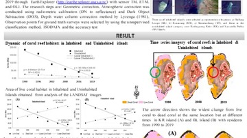
Coral reefs on inhabited and uninhabited small islands, Spermonde archipelago, Indonesia
Corresponding paper: CORAL REEFS ON INHABITED AND UNINHABITED SMALL ISLANDS, SPERMONDE ARCHIPELAGO, INDONESIA
Auhor(s): N. Nurdin, K. Amri, A. R. Rasyid, D. A. T. Pulubuhu, N. Nurdin, and T. Komatsu
Volume: XLIII-B3-2021 / 2021
https://doi.org/10.5194/isprs-archives-XLIII-B3-2021-609-2021
Invasion of Savannas by Prosopis Trees in Eastern Africa: Exploring their Impacts on LULC Dynamics, Livelihoods and Implications on Soil Organic Carbon Stocks
Corresponding paper: INVASION OF SAVANNAS BY PROSOPIS TREES IN EASTERN AFRICA: EXPLORING THEIR IMPACTS ON LULC DYNAMICS, LIVELIHOODS AND IMPLICATIONS ON SOIL ORGANIC CARBON STOCKS
Auhor(s): P. R. Mbaabu, U. Schaffner, and S. Eckert
Volume: XLIII-B3-2021 / 2021
https://doi.org/10.5194/isprs-archives-XLIII-B3-2021-335-2021
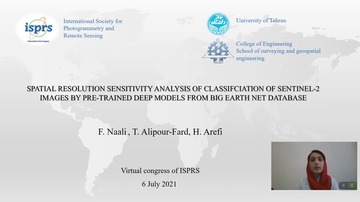
SPATIAL RESLUTION SENSITIVITY ANALYSIS OF CLASSIFCIATION OF SENTINEL-2 IMAGES BY PRE-TRAINED DEEP MODELS FROM BIG EARTH NET DATABASE
Corresponding paper: SPATIAL RESLUTION SENSITIVITY ANALYSIS OF CLASSIFCIATION OF SENTINEL-2 IMAGES BY PRE-TRAINED DEEP MODELS FROM BIG EARTH NET DATABASE
Auhor(s): F. Naali, T. Alipour-Fard, and H. Arefi
Volume: XLIII-B3-2021 / 2021
https://doi.org/10.5194/isprs-archives-XLIII-B3-2021-87-2021
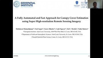
A FULLY AUTOMATED AND FAST APPROACH FOR CANOPY COVER ESTIMATION USING HIGH-RESOLUTION REMOTE SENSING IMAGERY
Corresponding paper: A FULLY AUTOMATED AND FAST APPROACH FOR CANOPY COVER ESTIMATION USING SUPER HIGH-RESOLUTION REMOTE SENSING IMAGERY
Auhor(s): M. Maimaitijiang, V. Sagan, S. Bhadra, C. Nguyen, T. C. Mockler, and N. Shakoor
Volume: V-3-2021 / 2021
https://doi.org/10.5194/isprs-annals-V-3-2021-219-2021