
XXIV ISPRS Congress
2021 Digital Edition
Nice, France, 05.07.2021 - 09.07.2021
Organizer: Société Française de Photogrammétrie et de Télédétection / Nicolas Paparoditis
Type of Event: Congress
Multi Media Type: Remote
Session: IPS.WE.1.III
Interactive Poster Session - 7th July
Single Presentations
Deep Bayesian active learning in high-resolution satellite images for change detection in urban and suburban areas
Corresponding paper: DEEP BAYESIAN ACTIVE LEARNING IN HIGH-RESOLUTION SATELLITE IMAGES FOR CHANGE DETECTION IN URBAN AND SUBURBAN AREAS
Auhor(s): L. Ragia and A. Panagiotopoulou
Volume: V-3-2021 / 2021
https://doi.org/10.5194/isprs-annals-V-3-2021-175-2021

Time series analysis for monitoring seagrass habitat and environment in Busuanga, Philippines using Google Earth Engine
Corresponding paper: TIME SERIES ANALYSIS FOR MONITORING SEAGRASS HABITAT AND ENVIRONMENT IN BUSUANGA, PHILIPPINES USING GOOGLE EARTH ENGINE
Auhor(s): A. Tamondong, T. Nakamura, T. E. A. Quiros, and K. Nadaoka
Volume: XLIII-B3-2021 / 2021
https://doi.org/10.5194/isprs-archives-XLIII-B3-2021-109-2021
The use of spectral and textural features in crop type mapping using Sentinel-2A images: A case study, Çukurova Region, Turkey
Corresponding paper: THE USE OF SPECTRAL AND TEXTURAL FEATURES IN CROP TYPE MAPPING USING SENTINEL-2A IMAGES: A CASE STUDY, ÇUKUROVA REGION, TURKEY
Auhor(s): A. Tuzcu Kokal, A. F. Sunar, A. Dervisoglu, and S. Berberoglu
Volume: XLIII-B3-2021 / 2021
https://doi.org/10.5194/isprs-archives-XLIII-B3-2021-117-2021
Assessment of flooded areas caused by a dam break (sardoba dam, uzbekistan)
Corresponding paper: ASSESSMENT OF FLOODED AREAS CAUSED BY A DAM BREAK (SARDOBA DAM, UZBEKISTAN)
Auhor(s): B. Tavus, S. Kocaman, and C. Gokceoglu
Volume: XLIII-B3-2021 / 2021
https://doi.org/10.5194/isprs-archives-XLIII-B3-2021-291-2021
DROACOR Reflectance Retrieval for Hyperspectral Mineral Exploration Using a Ground-Based Rotating Platform
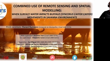
The combined use of remote sensing and spatial modelling: when surface water impacts african buffalo (syncerus caffer caffer) movements in savanna environments
Corresponding paper: COMBINED USE OF REMOTE SENSING AND SPATIAL MODELLING: WHEN SURFACE WATER IMPACTS BUFFALO (SYNCERUS CAFFER CAFFER) MOVEMENTS IN SAVANNA ENVIRONMENTS
Auhor(s): F. Rumiano, C. Gaucherel, P. Degenne, E. Miguel, S. Chamaillé-Jammes, H. Valls-Fox, D. Cornélis, M. de Garine-Wichatitsky, H. Fritz, A. Caron, and A. Tran
Volume: XLIII-B3-2021 / 2021
https://doi.org/10.5194/isprs-archives-XLIII-B3-2021-631-2021
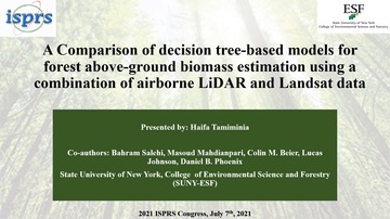
A comparison of decision tree-based models for forest above-ground biomass estimation using a combination of airborne lidar and landsat data
Corresponding paper: A COMPARISON OF DECISION TREE-BASED MODELS FOR FOREST ABOVE-GROUND BIOMASS ESTIMATION USING A COMBINATION OF AIRBORNE LIDAR AND LANDSAT DATA
Auhor(s): H. Tamiminia, B. Salehi, M. Mahdianpari, C. M. Beier, L. Johnson, and D. B. Phoenix
Volume: V-3-2021 / 2021
https://doi.org/10.5194/isprs-annals-V-3-2021-235-2021

Evaluation of Machine Learning Classifiers for Mapping Falcata Plantations in Sentinel-2 Image
Corresponding paper: EVALUATION OF MACHINE LEARNING CLASSIFIERS FOR MAPPING FALCATA PLANTATIONS IN SENTINEL-2 IMAGE
Auhor(s): J. R. Santillan and J. L. E. Gesta
Volume: XLIII-B3-2021 / 2021
https://doi.org/10.5194/isprs-archives-XLIII-B3-2021-103-2021
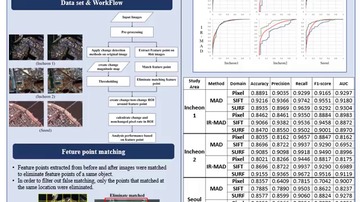
Comparison of pixel-based and feature-based approach for small object change detection
Corresponding paper: COMPARISON OF PIXEL-BASED AND FEATURE-BASED APPROACH FOR SMALL OBJECT CHANGE DETECTION
Auhor(s): J. Seo and T. Kim
Volume: XLIII-B3-2021 / 2021
https://doi.org/10.5194/isprs-archives-XLIII-B3-2021-353-2021
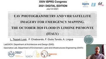
UAV photogrammetry and VHR satellite imagery for emergency mapping. The October 2020 flood in Limone Piemonte (Italy)

MULTISPECTRAL AND MOBILE MAPPING ISPRS WG III/5 DATA SET: FIRST ANALYSIS OF THE DATASET IMPACT
Corresponding paper: MULTISPECTRAL AND MOBILE MAPPING ISPRS WG III/5 DATA SET: FIRST ANALYSIS OF THE DATASET IMPACT
Auhor(s): M. Previtali, M. Garramone, and M. Scaioni
Volume: XLIII-B3-2021 / 2021
https://doi.org/10.5194/isprs-archives-XLIII-B3-2021-229-2021
Tls and short-range photogrammetric data fusion for buildings 3D modeling
Corresponding paper: TLS AND SHORT-RANGE PHOTOGRAMMETRIC DATA FUSION FOR BUILDINGS 3D MODELING
Auhor(s): P. R. S. Ruiz, C. M. Almeida, M. B. Schimalski, V. Liesenberg, and E. A. Mitishita
Volume: XLIII-B3-2021 / 2021
https://doi.org/10.5194/isprs-archives-XLIII-B3-2021-279-2021
Determination of regions suitable for agriculture in the gordon cosens forest of ontario by means of analytical hierarchy process with fuzzy logic inference
Corresponding paper: DETERMINATION OF REGIONS SUITABLE FOR AGRICULTURE IN THE GORDON COSENS FOREST OF ONTARIO BY MEANS OF ANALYTICAL HIERARCHY PROCESS WITH FUZZY LOGIC INFERENCE
Auhor(s): R. Pittman, B. Hu, and G. Sohn
Volume: XLIII-B3-2021 / 2021
https://doi.org/10.5194/isprs-archives-XLIII-B3-2021-623-2021
Spatio-temporal analysis of land use dynamics and its potential implications on land surface temperature in lahore district, punjab, pakistan
Corresponding paper: SPATIO-TEMPORAL ANALYSIS OF LAND USE DYNAMICS AND ITS POTENTIAL IMPLICATIONS ON LAND SURFACE TEMPERATURE IN LAHORE DISTRICT, PUNJAB, PAKISTAN
Auhor(s): M. Sohail, S. S. F. Ali, E. Fatima, and D. A. Nawaz
Volume: XLIII-B3-2021 / 2021
https://doi.org/10.5194/isprs-archives-XLIII-B3-2021-359-2021

Detecting the sources of ice block falls at the martian north polar scarps by analysis of multi-temporal HiRISE imagery
Corresponding paper: DETECTING THE SOURCES OF ICE BLOCK FALLS AT THE MARTIAN NORTH POLAR SCARPS BY ANALYSIS OF MULTI-TEMPORAL HIRISE IMAGERY
Auhor(s): S. Su, L. Fanara, X. Zhang, K. Gwinner, E. Hauber, and J. Oberst
Volume: XLIII-B3-2021 / 2021
https://doi.org/10.5194/isprs-archives-XLIII-B3-2021-673-2021
comparison of multi-image deep-learning super-resolution for passive microwave images of arctic sea ice
Corresponding paper: COMPARISON OF MULTI-IMAGES DEEP LEARNING SUPER RESOLUTION FOR PASSIVE MICROWAVE IMAGES OF ARCTIC SEA ICE
Auhor(s): X. Shen, X. Liu, Y. Yao, and T. Feng
Volume: XLIII-B3-2021 / 2021
https://doi.org/10.5194/isprs-archives-XLIII-B3-2021-497-2021