
XXIV ISPRS Congress
Nice, France, 06.06.2022 - 11.06.2022
Organizer: Société Française de Photogrammétrie et de Télédétection / Nicolas Paparoditis
Type of Event: Congress
Multi Media Type: Hybrid
Session: P_20
Poster Session 20 - 10th June - Poster 2020/2021
Single Presentations
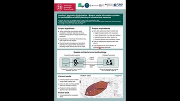
TOWARDS INNOVATIVE PARTICIPATION-ORIENTED PLANNING OF INFRASTRUCTURE MEASURES
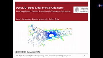
DeepLIO - Deep LiDAR Inertial Sensor Fusion For Odometry Estimation

Visualizing Life In An Informal Settlement Of South Africa Using Web Maps And Story Maps

Monitoring Terrain Deformations Caused By Underground Mining Using UAV Data
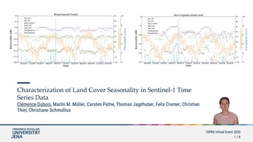
Characterization Of Land Cover Seasonality In Sentinel-1 Time Series Data
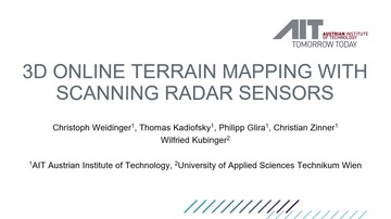
3D Online Terrain Mapping With Scanning Radar Sensors
Integration Of Multitemporal Sentinel-1 And Sentinel-2 Imagery For Land-Cover Classification Using Machine Learning Methods

Identification Of Misclassified Pixels In Semantic Segmentation With Uncertainty Evaluation
3D Reconstruction Of On-/Offshore Wind Turbines For Manual And Computational Visual Inspection

Application Of UAV Surveys For Evaluating The Productivity Levels Of Traditional And Mechanised Farmers In A Customary Land Tenure System In Nigeria

Marrying Deep Learning And Data Fusion For Accurate Semantic Labeling Of Sentinel-2 Images

Detection And Modelling Of Submersed Vegetation And Deadwood From Topo-Bathymetric UAV-LiDAR

RPAS Based Tracking Of Machinery Used In Asphalt Paving Process

Combining Environmental And Landsat Analysis Ready Data For Vegetation Mapping: A Case Study In The Brazilian Savanna Biome

Evaluation Of Interior Orientation Modelling For Cameras With Aspheric Lenses And Image Pre-Processing With Special Emphasis To SFM Reconstruction

Accurate Calculation Of Tree Stem Traits In Forest By Local Correction Of Point Cloud Registration
Corresponding paper: ACCURATE CALCULATION OF TREE STEM TRAITS IN FORESTS BY LOCAL CORRECTION OF POINT CLOUD REGISTRATION
Auhor(s): H. Kawasaki and H. Masuda
Volume: XLIII-B2-2022 / 2022
https://doi.org/10.5194/isprs-archives-XLIII-B2-2022-209-2022
Photogrammetry And Computed Tomography Point Cloud Registration Using Virtual Control Points
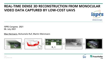
Real-Time Dense 3D Reconstruction From Monocular Video Data Captured by Low-cost UAVs

Investigating Standardized 3D Input Data For Solar Photovoltaic Potentials In The Netherlands

A Case Study Of Monitoring Maize Dynamics In Serbia By Utilizing Sentinel-1 Data And Growing Degree Days
Lake Ice Detection From Sentinel-1 SAR With Deep Learning
Lake Ice Monitoring With Webcams And Crowd-Sourced Images
Plastic Surgery For 3D City Models: A Pipeline For Automatic Geometry Refinement And Semantic Enrichment

An Accurate Real-Time UAV Mapping Solution For The Generation Of Orthomosaics And Surface Models

A Concept For The Segmentation Of Individual Urban Trees From Dense Mls Point Clouds
Remote Sensing And Multivariate Logistic Regression Model For The Estimation Of Urban Expansion (Case Of Darkhan City, Mongolia)

Estimating Built-Up Area Change In Ulaanbaatar City, Mongolia

AI4GEO : a Data Intelligence Platform for 3D Geospatial Mapping
UHI Estimation Based On Aster And MODIS Satellite Imagery: First Results On Strasbourg City, France

Evaluation Of The Seasonal Lst-Air Temperature Discrepancies And Their Relation To Local Climate Zones (Lcz) In Strasbourg
Infrastructure Degradation And Post-Disaster Damage Detection Using Anomaly Detecting Generative Adversarial Networks
Evaluating Surface Mesh Reconstruction Of Open Scenes
Image blur detection method based on gradient information in directional statistics