2022 Virtual Keynote Speaker Series
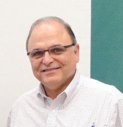
Costas Armenakis
Geospatial information extraction from EO images using deep learning approaches
Friday, 25.02.2022 at 15:00 CET
ABSTRACT
Aerial, satellite and low altitude images are the main sources for extracting geometric, thematic, and physical information about the Earth and its landscapes. The challenge is on how to develop automated algorithms to extract accurate geospatial information from the image data. In the recent years we have observed a paradigm shift in the processing and analysis of image scenes by using of deep learning methods. Deep learning methods are based on representation learning for feature, pattern and object recognition or grouping from the data. In this presentation examples of change detection, tree species classification, autonomous UAV navigation, and image semantic segmentation using supervised, semi-supervised, learning transfer, and reinforcement learning methods will be discussed.
BIOGRAPHY
Costas Armenakis is a Professor of Geomatics Engineering, Department of Earth & Space Science & Engineering at the Lassonde School of Engineering, York University in Toronto Canada. He is working in the areas of photogrammetric engineering and remote sensing mapping focusing on unmanned mobile sensing and mapping systems and the use of unmanned aerial vehicle systems for geomatics. His research interests are on sensor localization and navigation, generation of 3D high-definition mapping products, AI and intelligent systems, collaborative platform mapping, and rapid computational methods. He is a Fellow of the International Society for Photogrammetry and Remote Sensing (ISPRS) and has served as President of the ISPRS Technical Commission IV on Digital Mapping and GeoDatabases and as Co-Chair of the ISPRS ICWG I/VB Unmanned Vehicles Systems (UVS): Sensors and Applications. Currently he is Co-Chair the ISPRS ICWG I/II UAS & Small Multi-Sensor Platforms: Concepts & Applications.