High Precision Photogrammetric Data Set for Building Reconstruction and Terrain Modelling with Ground Truth
This test data set was prepared for use in the project AMOBE (Automation of Digital Terrain Model Generation and
Man-Made Object Extraction from Aerial Images) being conducted at ETH Zurich between the photogrammetric and vision
groups and in cooperation with SRI. We are distributing this data with the purpose of providing a basis for comparison
and evaluation of image understanding techniques, in particular those dealing with the reconstruction of man-made
objects. Features of this data set include provision of the full photogrammetric information, four-way image overlap
and ground truth.
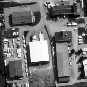 |
| The Avenches area |
The set includes the following data:
- High resolution, large-scale colour aerial images RGB images, image scale 1:5,000, images scanned with a geometrically
precise photogrammetric scanner with 15 microns pixel size. Four images, forming a 2 x 2 block, with 60% forward and
sidewards overlap were used. To reduce the amount of data only two image subsets (an industrial and a residential area)
will be distributed. These areas are 1800 x 1800 pixels and are imaged in all 4 aerial images.
Grey level images can be derived from the RGB images by making an RGB to HSV transformation and using the V channel
as a grey level image. These images have not been included in this data set to reduce data size.
- Full photogrammetric and other information on the images.
- Transformation parameters from scanner (pixel) to photo (photogrammetric) coordinate system.
- Interior orientation parameters (camera constant, coordinates of principal point).
- Exterior orientation parameters They were determined by a bundle adjustment and include the position of
perspective centers, rotation matrices and variance-covariance matrices (i.e. precision estimates) for the
parameters of each image.
- Time information, latitude and longitude This information can be used for shape-from-shadow computations.
- Digital Terrain Models (DTMs) Data measured manually with a high accuracy photogrammetric instrument (expected
accuracy = 0.1 m). The DTM is in ASCII format with a 10 m grid spacing. Contour information is contained in DXF- and
IGES-format CAD models.
- Buildings Separate DXF and IGES files for the residential and industrial area contain building roof models.
These models are represented in terms of line entities manually measured by an operator to an expected accuracy of 0.1 m.
- Orthophotos The residential and industrial areas in all 4 images were orthorectified (terrain-corrected) by using the
DTMs. The ground resolution is approx. equal to the resolution of the original images. The map coordinates of the orthophotos
and the grid spacing are given. These images are not included in this data set to reduce data size. They can be made available
upon request from {mason,manos}@p.igp.ethz.ch
- Digital Surface Model (DSM) (only for residential area) The difference to DTM is that DSM contains the visible
surface, i.e. also 3-D objects not included in the DTM like buildings, trees etc. The DSM was generated with a commercial
photogrammetric system (the Helava DPW 770) and has a grid spacing of 0.25 m. The DSM is distributed both in numeric form
and as a grey level image.
All images are in Sun Raster format.
Description file
dataset_descr.pdf
The files contain all the description of the data set and the images. Thus, the images can be viewed first before
deciding to transfer the data.
Get the data
You can download the data here: dataset.tar.gz
The size of the uncompressed data is 85 Mbytes. The top directory of the uncompressed data contains a description of the
data set in the file dataset_descr.ps. NOTE that this file includes the description of all data, although some of them (grey
level images and orthophotos) have not been included in dataset.tar
©Institute of Geodesy and Photogrammetry, ETH Zurich