Data description
The data set contains 38 patches (of the same size), each consisting of a true orthophoto (TOP) extracted from a larger TOP mosaic, see Figure below and a DSM.
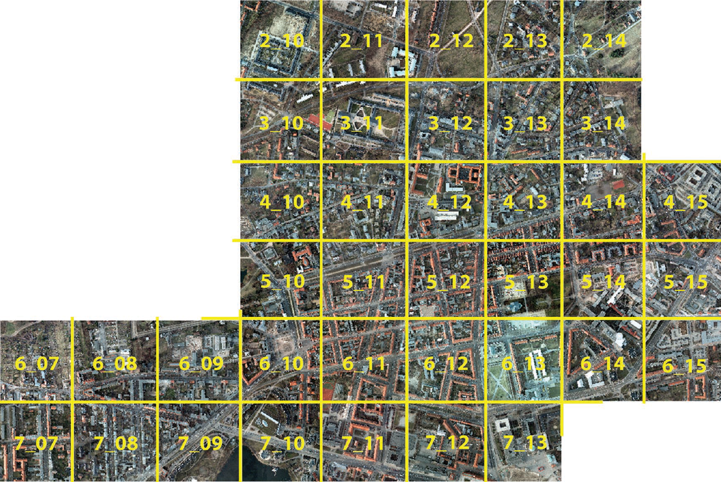
Outlines of all patches given in Tab.1 overlaid with the true orthophoto mosaic. Numbers refer to the individual patch numbers, encoded in the filenames as well
The ground sampling distance of both, the TOP and the DSM, is 5 cm. The DSM was generated via dense image matching with Trimble INPHO 5.6 software and Trimble INPHO OrthoVista was used to generate the TOP mosaic. In order to avoid areas without data (“holes”) in the TOP and the DSM, the patches were selected from the central part of the TOP mosaic and none at the boundaries. Remaining (very small) holes in the TOP and the DSM were interpolated.
The TOP come as TIFF files in different channel composistions, where each channel has a spectral resolution of 8bit:
- IRRG: 3 channels (IR-R-G)
- RGB: 3 channels (R-G-B)
- RGBIR: 4 channels (R-G-B-IR)
In this way participants can pick the data needed conveniently.
The DSM are TIFF files with one band; the grey levels (corresponding to the DSM heights) are encoded as 32 bit float values. The TOP and the DSM are defined on the same grid (UTM WGS84). Each tile comes with an affine transformation file (tiff world file) in order to enable a re-composition of images to larger mosaics if desired.
In addition to the DSMs we provide so-called normalised DSMs, that is, after ground filtering the ground height is removed for each pixel, leading to an representation of heights above the terrain. This data was produced using some fully automatic filtering workflow, without manual quality control. Hence, we do not guarantee error free data here, this is just for researchers to help using height data, other than the absolute DSM. In the download folder you find the corresponding zip-file. If you unpack you find a readme.txt which you should read before using the data. The scripts based on lastools are also contained, so participants might want to tune them. We however do not provide support.
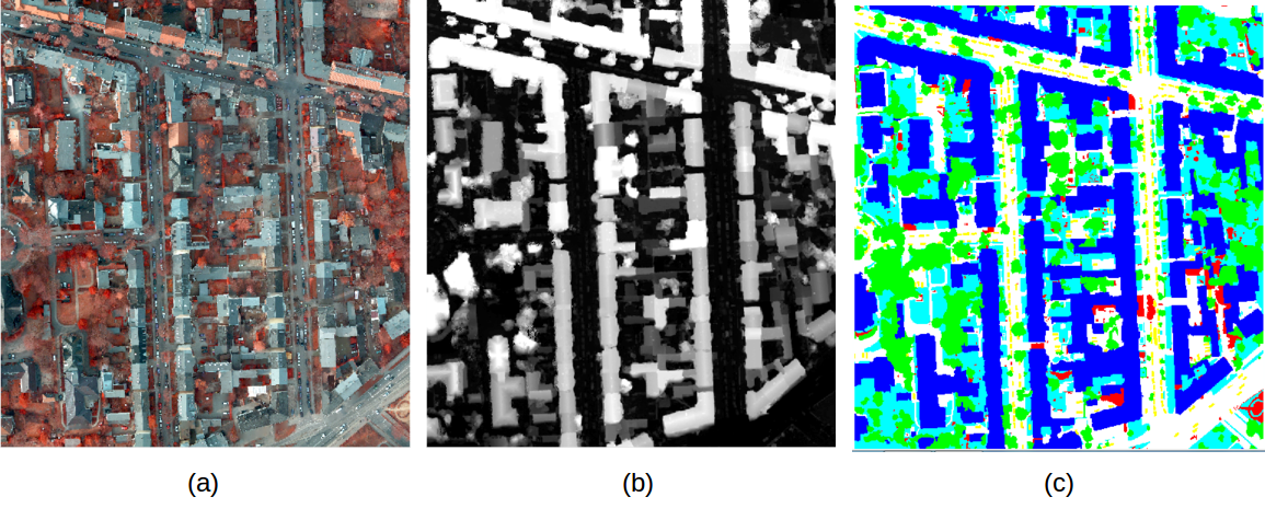
Example patches of the semantic object classification contest with (a) true orthophoto, (b) DSM, and (c) ground truth
Labelled ground truth is provided for only one part of the data. The ground truth of the remaining scenes will remain unreleased and stays with the benchmark test organizers to be used for evaluation of submitted results. Participants shall use all data with ground truth for training (see Table) or internal evaluation of their method.
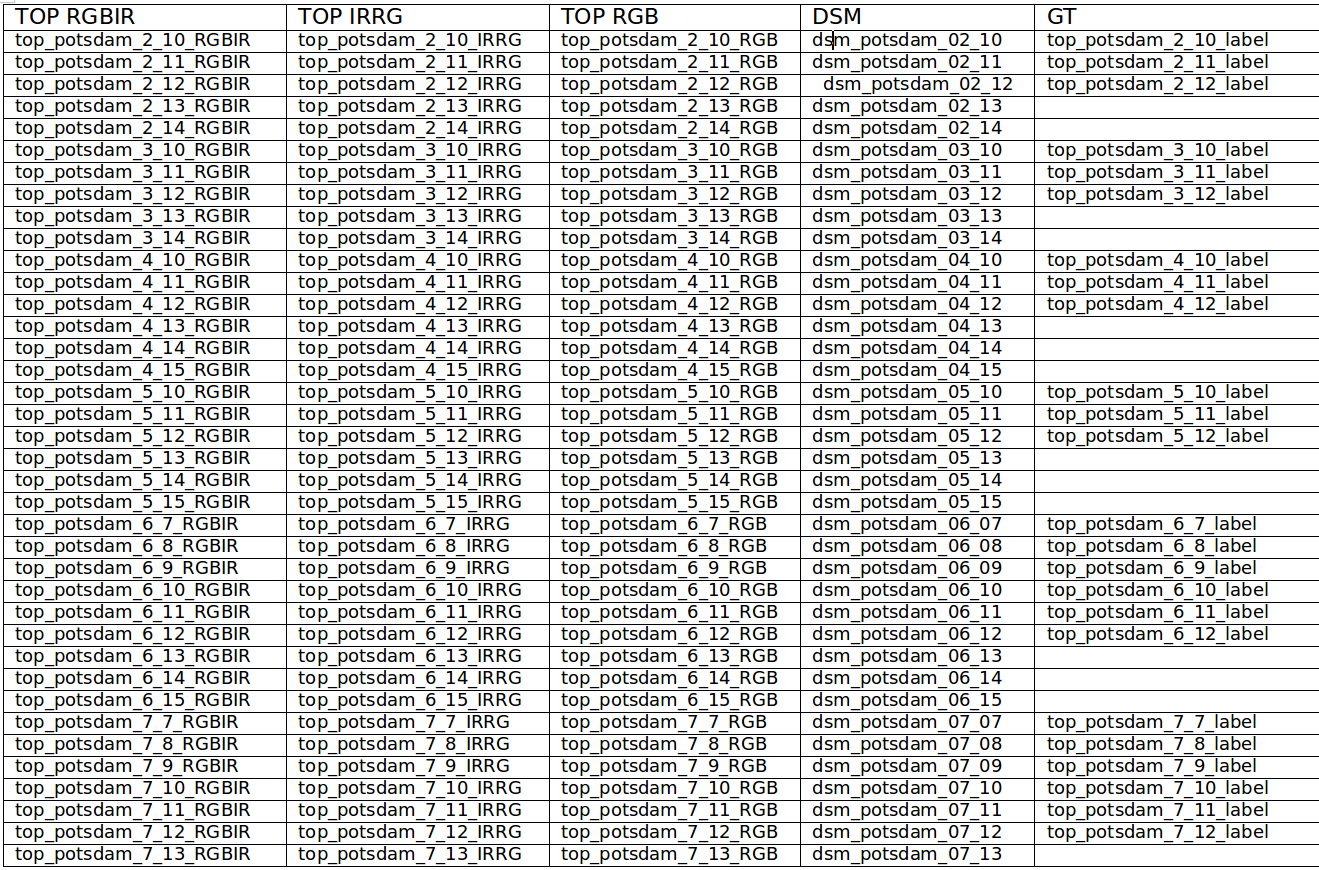
Overview of the individual patches (with .tif extensions, all images have dimension 6000 x 6000 pixels). Filenames of TOP RGBIR: true orthophoto with four channels red, green, blue, infrared; TOP IRRG: true orthophoto with three channels infrared, red, green; TOP RGB: true orthophoto with three channels red, green, blue; DSM: digital surface model; GT: ground truth labels (empty if not made available to participants and used by the benchmark organizers for evaluation of the results). Note that no gaps exist between neighbouring image tiles to enable models with context, better computation of normalized DSMs etc. The first number always indicates the row (top to bottom, i.e. north to south) and the second number the column (left to right, i.e. west to east). For example, direct neighbours of 5_12 are 4_12 (above), 6_12 (below), 5_11 (left), and 5_13 (right). All images come with corresponding .tfw-files that provide geo-reference in UTM WGS84 coordinates.
Acknowledgement
We thank BSF Swissphoto for providing us the data free of charge.