Introduction
NEW - As of Summer 2018 the reference data is available to everyone and we stopped evaluating the submissions by participants. You will find the the download links to all the data, includig reference 2D oulines and 3D planes here ».
The automated extraction of urban objects from data acquired by airborne sensors has been an important topic of research in photogrammetry for at least two decades. One observation that can be made is that most of the papers dealing with urban object extraction focus on a single object class, e.g. buildings, roads or, less frequently, trees. Typically, results are published for a few test sites available to the authors.
The aim of this project is to provide state-of-the-art data sets which can be used by interested researchers in order to test own methods and algorithms on urban object classification and building reconstruction.
Evaluation results are made available online.
The evaluation results may be used by the participants for any scientific publication, however, note that we do not perform the evaluation anymore.
Detailled information about the test and the datasets is available from a pdf file which can be downloaded here. In the following a brief overview is provided.
Object classes
Two test sites, each containing several test areas for which reference data are available, are provided for the participants in this project in order to evaluate techniques for the extraction of various urban object classes:
- Urban object detection: The participants may choose to detect single object classes, or they can try to extract several object classes simultaneously, for instance to benefit from context information, i.e. the information contained in the mutual arrangement of objects in complex urban scenes such as those distributed in this project. Reference data are available for a variety of object classes. The object classes typically discerned in urban classification are building, road, tree, low vegetation/grass, and artificial ground. This list is sometimes augmented by car if very high-resolution data (such as those in this project) are used. Since such a definition is not useful for evaluating the results of road extraction, in this project, the class artificial ground was split into road and artificial ground other than road.
- 3D Building Reconstruction: The participants shall reconstruct detailed 3D roof structures in the test areas. Detailed 3D models of roofs are available as reference data. They will be used to evaluate the quality of the roof plane segmentation process as well as the geometrical accuracy of the outline polygons of the roof planes.
Dataset 1: Vaihingen/Enz, Germany
This test data set was captured over Vaihingen in Germany. The data set is a subset of the data used for the test of digital aerial cameras carried out by the German Association of Photogrammetry and Remote Sensing (DGPF). It consists of three test areas for which reference data for various object classes are available (yellow areas in the figure below) and a larger test site “Roads” for road extraction (blue area in the same figure):
- Area 1: “Inner City”: This test area is situated in the centre of the city of Vaihingen. It is characterized by dense development consisting of historic buildings having rather complex shapes, but also has some trees.
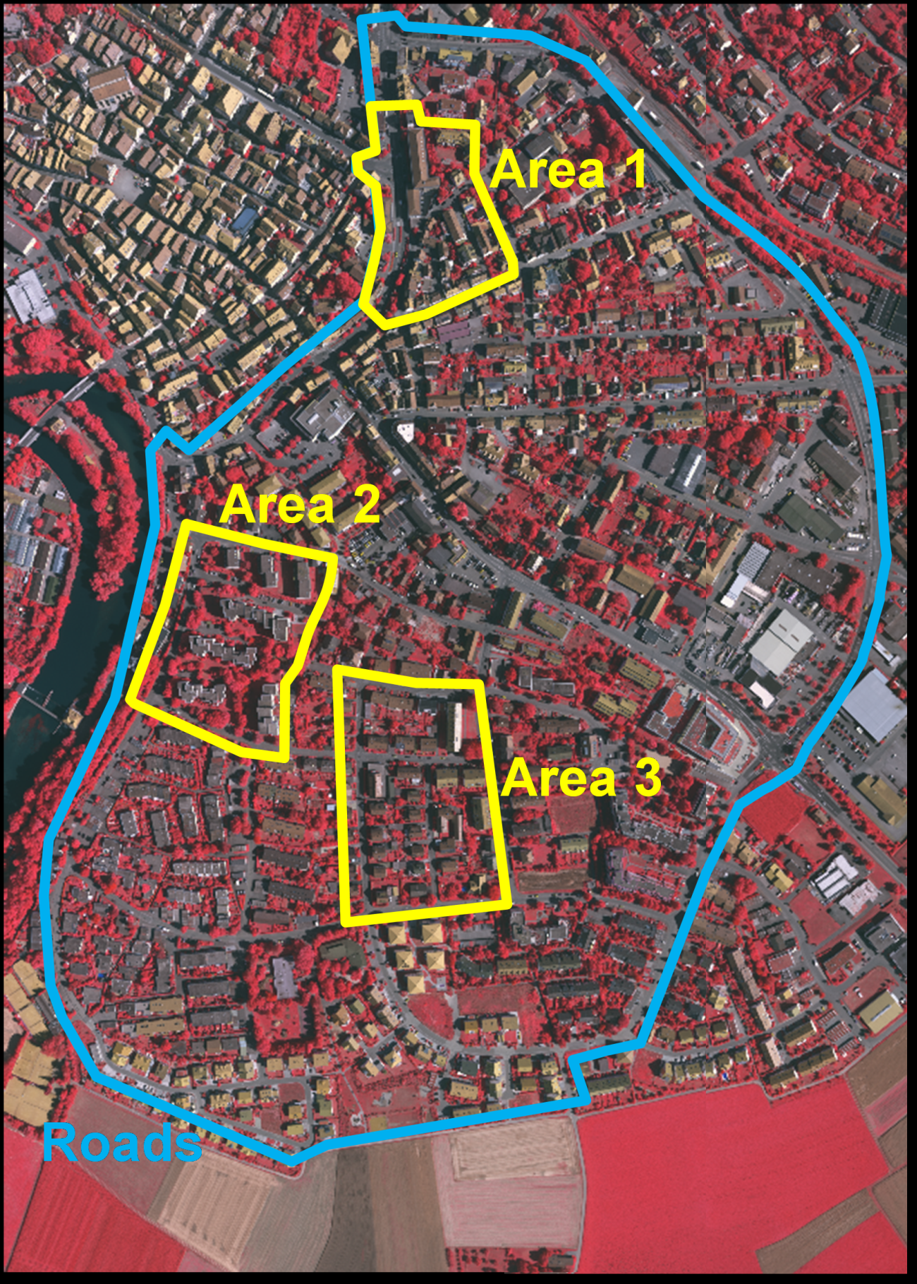
- Area 2: “High Riser”: This area is characterized by a few high-rising residential buildings that are surrounded by trees.
- Area 3: “Residential Area”: This is a purely residential area with small detached houses.
- “Roads”: This area encloses all the other test sites and can be used for testing urban road extraction techniques.
For each of these test areas, the following data are distributed:
- Digital Aerial Images and Orientation Parameters: The images are a part of the Intergraph/ZI DMC block with 8 cm ground resolution. Each area is visible in multiple images from several strips. The orientation parameters are distributed together with the images.
- Airborne Laserscanner Data: The test area was covered by altogether 10 strips captured with a Leica ALS50 system. Inside an individual strip the average point density is 4 points/m2. Apart from the original point clouds, digital surface model (DSM) is also made available.
- NEW since January 2013: we now provide a DSM from image matching as well as a TrueOrtho photo.
Dataset 2: Toronto, Canada
This data set covers an area of about 1.45 km2 in the central area of the City of Toronto in Canada which was captured by the Microsoft Vexcel’s UltraCam-D (UCD) camera and the Optech’s airborne laserscanner (ALTM-ORION M). The images have a ground resolution of 15 cm, while the laserscanner provided 6 points/m2. The “Downtown Toronto” data contains representative scene characteristics of modern mega city in the North America including a mixture of low- and high-story buildings with a wide variety of rooftop structures and street and road features. The test data can be divided into three test sites, 'Area 4’, ‘Area 5’, and ‘Entire Area’. The areas ‘Area 4’ and ‘Area 5’ should be used for testing object extraction and building reconstruction techniques, while the entire test area can be used for road detection.
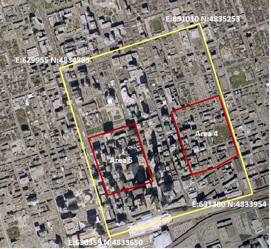
- Area 4: This area contains a mixture of low and high story buildings, showing various degrees of shape complexity in rooftop structure and rooftop furniture. The scene also contains different urban objects including cars, trees, street furniture, roads and parking lots.
- Area 5: This area represents a typical example of a cluster of high-rise buildings in a modern mega city in North America. The scene contains shadows casted by high buildings, under which various types of urban objects (e.g., cars, street furniture, and roads) can be found.
Conditions of use
Both datasets are subject to different conditions of use which are detailed in the document. You will need to agree to those conditions.